
Berehivskyi Raion
Encyclopedia
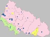
The Berehove Raion is a district (raion) in the Zakarpattia oblast
in the westernmost corner of Ukraine
. The main city and administrative center is Berehove
. For over half of millennium the territory of the district was part of Bereg County.
. The district also borders with such districts of the region as Mukachevo, Uzhhorod, Irshava, and Vynohradove.
Through the district flow three rivers Tisza
, Borzhava, and Salva
. Most of the territory is an open plain with some elevation at its north-eastern portion, closer to the Carpathian
ridges.
, the population of Berehivskyi Raion is 54,614, which is about 4% of the Zakarpattia region
population. About 50,000 reside in a rural area.
Although ethnic Hungarians in Ukraine are in majority here (76.1%), ethnic group
s are relatively numerous in Berehove Raion. The largest of these are Ukrainians
(18.8%), Russians
(0.7%), Roma (4.1%).
Note that most of the settlements adopted Hungarian-like names since the Ukrainian independence. Some settlements' names end with o, unlike within the Ukrainian grammar which requires ending e. Those names are traditional and in the local Ukrainian dialect.
Administrative center: Berehovo (Beregszász)
Town municipality: Batyovo (Batyu)
Rural municipalities:
Note: Hungarian name of places are given in parenthesis.
Through the district runs one of the European route which in fact consists of two different ones and
and  . The highway runs from the north from Mukacheve
straight to Berehove after which it continues on south-east along the Hungarian border towards Romania
. A regional highway of a state importance branches away from E58/81 in Berehove towards the Hungarian border and in the Astei municipality is going through a border checkpoint
traveling towards Jand
(Hungary
). From Berehove also originates a national highway that traveling through Vynohradiv
heads towards Khust
, connecting to H09.
Beside the Astei checkpoint there two others of local importance located in the western portion of the district, one in the Koson municipality, another one in the Batrad.
Out of local highways through the district run such highways as T0714, T0707, T0715, T0731, T0717. The biggest local highway is which runs through most of the district.
Railroads
There are six railroad stations out of which the stations in Batyovo and Berehove are the biggest. The station Batyovo, in fact, is situated at the intersection connecting such important cities of the region as Chop
, Mukacheve
, and Berehove
.
Zakarpattia Oblast
The Zakarpattia Oblast is an administrative oblast located in southwestern Ukraine. Its administrative center is the city of Uzhhorod...
in the westernmost corner of Ukraine
Ukraine
Ukraine is a country in Eastern Europe. It has an area of 603,628 km², making it the second largest contiguous country on the European continent, after Russia...
. The main city and administrative center is Berehove
Berehove
Berehove is a city located in the Zakarpattia Oblast in western Ukraine, near the border with Hungary.Serving as the administrative center of the Berehove Raion , the city itself is also designated as a separate raion within the oblast...
. For over half of millennium the territory of the district was part of Bereg County.
Location
The district covers 635 km² (245.2 sq mi) and composes about 5.5% territory of the region. It is located at the south-western portion of the region on the border with HungaryHungary
Hungary , officially the Republic of Hungary , is a landlocked country in Central Europe. It is situated in the Carpathian Basin and is bordered by Slovakia to the north, Ukraine and Romania to the east, Serbia and Croatia to the south, Slovenia to the southwest and Austria to the west. The...
. The district also borders with such districts of the region as Mukachevo, Uzhhorod, Irshava, and Vynohradove.
Through the district flow three rivers Tisza
Tisza
The Tisza or Tisa is one of the main rivers of Central Europe. It rises in Ukraine, and is formed near Rakhiv by the junction of headwaters White Tisa, whose source is in the Chornohora mountains and Black Tisa, which springs in the Gorgany range...
, Borzhava, and Salva
Salva
Salva may refer to:*Common sage*Salva , from Italy*Salva, Bistriţa-Năsăud, a commune in Romania*Şəlvə, Khojali, Azerbaijan*Şəlvə, Lachin, Azerbaijan*Bartolomé Salvá-Vidal, Spanish tennis player...
. Most of the territory is an open plain with some elevation at its north-eastern portion, closer to the Carpathian
Carpathian
Carpathian may refer to:*Carpathian Mountains of Central and Eastern Europe*Carpathian Convention on sustainable development in that region*Carpathian Shepherd Dog, a Romanian sheep dog*Subcarpathian Voivodeship, an administrative division of Poland...
ridges.
Demographics
According to the 2001 Ukrainian CensusUkrainian Census (2001)
The first Ukrainian Census was carried out by State Statistics Committee of Ukraine on 5 December 2001, twelve years after the last Soviet Union census in 1989....
, the population of Berehivskyi Raion is 54,614, which is about 4% of the Zakarpattia region
Zakarpattia Oblast
The Zakarpattia Oblast is an administrative oblast located in southwestern Ukraine. Its administrative center is the city of Uzhhorod...
population. About 50,000 reside in a rural area.
Although ethnic Hungarians in Ukraine are in majority here (76.1%), ethnic group
Ethnic group
An ethnic group is a group of people whose members identify with each other, through a common heritage, often consisting of a common language, a common culture and/or an ideology that stresses common ancestry or endogamy...
s are relatively numerous in Berehove Raion. The largest of these are Ukrainians
Ukrainians
Ukrainians are an East Slavic ethnic group native to Ukraine, which is the sixth-largest nation in Europe. The Constitution of Ukraine applies the term 'Ukrainians' to all its citizens...
(18.8%), Russians
Russians
The Russian people are an East Slavic ethnic group native to Russia, speaking the Russian language and primarily living in Russia and neighboring countries....
(0.7%), Roma (4.1%).
Administrative division
The Berehove district (raion) consists of one town municipality and 30 rural municipalities, all of which also have their respective administrative councils (rada). The administrative center of the district is situated in the city of Berehovo which is not part of the district administration. The city of Berehovo was designated into a special city municipality of regional significance in 2001. Some of the municipalities of the district consist of several settlements, mostly rural.Note that most of the settlements adopted Hungarian-like names since the Ukrainian independence. Some settlements' names end with o, unlike within the Ukrainian grammar which requires ending e. Those names are traditional and in the local Ukrainian dialect.
Administrative center: Berehovo (Beregszász)
Town municipality: Batyovo (Batyu)
Rural municipalities:
- Astei (Luzhenka between 1945-1991, Asztély)
- Badalovo (Badaló)
- Batrad (Bótrágy), combines two villages Betrad and Horonhlab (Dzvinkoje between 1920-1938, Kisharangláb)
- Bene (Dobrosillya between 1945-1991, Bene)
- Berehuifalu (Nove Selo between 1920-1938 and 1944-1991, Beregújfalu)
- Borzhava (Velka Borshava between 1920-1938, Nagyborzsova)
- Vary (Variova between 1920-1938, Mezővári)
- Velyka Bakta (Nagybakta)
- Velyki Berehy (Brehy between 1920-1938, Nagybereg)
- Velyka Biyhan (Nagybégány), combines villages of Velyka Biyhan and Mala Biyhan (Kisbégány)
- Halabor (Bodoliv, between 1945-1991, Halábor)
- Hat (Gát), combines villages of Hat and Chikosh-Horonda (Čikosgorondov Dvor between 1920-1938 and 1944-1945, Csikósgorond)
- Hecha (Mezőgecse)
- Hut (Harazdivka Between 1945-1991, Gút)
- Dyida (Beregdéda)
- Zapson (Zastavnoje 1945-1991, Zápszony)
- Kvasovo (Kovászó)
- Kidyosh (Zmiyivka between 1945-1991, Kigyós)
- Koson (Kosyno between 1945-1995, Mezőkaszony)
- Mochola (Macsola), combines villages of Mochola and Hunyadi (Hunyadi)
- Muzhiyevo (Nagymuzsaly)
- Nyzhni Remety (Alsóremete), combines villages of Nyzhni Remety and Verkni Remety (Felsőremete)
- Orosiyevo (Sárosoroszi)
- Popovo (Csonkapapi), combines villages of Popovo, Male Popovo (Gašparov Dvor between 1920-1938 and 1944-1945, Sonyachne between 1945-1991, Tiszatanya or Papitanya), and Heten (Hetin between 1920-1938 and 1944-1945, Lypove between 1945-1991, Hetyen)
- Rafainovo (Rafajna Nové Selo between 1920-1938 and 1944-1945, Rafajnaújfalu)
- Svoboda (Vel'ky Bakos between 1920-1938 and 1944-1945, Nagybakos), combines villages of Svoboda, Badiv (Badótanya), Bakosh (Kisbakos), and Danylivka (Danilovka)
- Chetfalva (Chetovo between 1945-1991, Csetfalva)
- Choma (Tiszacsoma)
- Shom (Derenkovets between 1945-1991, Beregsom), combines villages of Shom and Kashtanovo (Vel'ky Dvor between 1920-1938 and 1944-1945, Vadastanya)
- Yanoshi (Janosovo between 1920-1938, Ivanivka between 1945-1991, Makkosjánosi), combines villages of Yanoshi and Balazher (Blazhejovo between 1920-1938 and 1944-1945, Dzvinkoye between 1945-1991, Balazsér)
Note: Hungarian name of places are given in parenthesis.
Transportation
HighwaysThrough the district runs one of the European route which in fact consists of two different ones
Mukacheve
Mukachevo or Mukacheve is a city located in the valley of the Latorica river in the Zakarpattia Oblast , in southwestern Ukraine. Serving as the administrative center of the Mukachivskyi Raion , the city itself is also designated as a separate raion within the oblast...
straight to Berehove after which it continues on south-east along the Hungarian border towards Romania
Romania
Romania is a country located at the crossroads of Central and Southeastern Europe, on the Lower Danube, within and outside the Carpathian arch, bordering on the Black Sea...
. A regional highway of a state importance branches away from E58/81 in Berehove towards the Hungarian border and in the Astei municipality is going through a border checkpoint
Border checkpoint
A border checkpoint is a place, generally between two countries, where travellers and/or goods are inspected. Authorization often is required to enter a country through its borders. Access-controlled borders often have a limited number of checkpoints where they can be crossed without legal...
traveling towards Jand
Jand
Jand may refer to:Settlements*Jand, Attock, town of Attock District*Jand, Chakwal, Union Council of Chakwal District*Jánd, village in the eastern HungaryOthers*Jand, Pidgin, a Nigerian slang word which refers to the United Kingdom...
(Hungary
Hungary
Hungary , officially the Republic of Hungary , is a landlocked country in Central Europe. It is situated in the Carpathian Basin and is bordered by Slovakia to the north, Ukraine and Romania to the east, Serbia and Croatia to the south, Slovenia to the southwest and Austria to the west. The...
). From Berehove also originates a national highway
Vynohradiv
Vynohradiv , , Yiddish: סעליש ) is a city in western Ukraine, Zakarpattia Oblast. It has 27,600 inhabitants . It is center of Vynohradiv Raion.-Location:The city lies near the river Tisza and the border with Romania...
heads towards Khust
Khust
Khust is a city located on the Khustets River in the Zakarpattia oblast in western Ukraine. It is near the confluence of the Tisza and Rika Rivers...
, connecting to H09.
Beside the Astei checkpoint there two others of local importance located in the western portion of the district, one in the Koson municipality, another one in the Batrad.
Out of local highways through the district run such highways as T0714, T0707, T0715, T0731, T0717. The biggest local highway is which runs through most of the district.
Railroads
There are six railroad stations out of which the stations in Batyovo and Berehove are the biggest. The station Batyovo, in fact, is situated at the intersection connecting such important cities of the region as Chop
Chop
Chop, CHOP, Chops, or CHOPS may refer to:-Music:*Embouchure, in music, a synonym for chops*CHOPS, Asian-American hip-hop producer, rapper and member of rap group Mountain Brothers*Chops , 2006...
, Mukacheve
Mukacheve
Mukachevo or Mukacheve is a city located in the valley of the Latorica river in the Zakarpattia Oblast , in southwestern Ukraine. Serving as the administrative center of the Mukachivskyi Raion , the city itself is also designated as a separate raion within the oblast...
, and Berehove
Berehove
Berehove is a city located in the Zakarpattia Oblast in western Ukraine, near the border with Hungary.Serving as the administrative center of the Berehove Raion , the city itself is also designated as a separate raion within the oblast...
.
External links
- http://www.ukrcensus.gov.ua/eng/results/general/nationality/Zakarpattia/
- Administrative division of Berehovo Raion (at Verkhovna Rada website)