

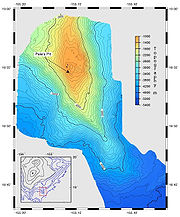
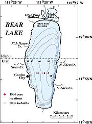
Bathymetric charts
Encyclopedia
Topographic map
A topographic map is a type of map characterized by large-scale detail and quantitative representation of relief, usually using contour lines in modern mapping, but historically using a variety of methods. Traditional definitions require a topographic map to show both natural and man-made features...
. Bathymetric charts are designed to present accurate, measurable description and visual presentation of the submerged terrain.
In an ideal case, the joining of a bathymetric chart and topographic map of the same scale and projection
Map projection
A map projection is any method of representing the surface of a sphere or other three-dimensional body on a plane. Map projections are necessary for creating maps. All map projections distort the surface in some fashion...
of the same geographic area would be seamless. The only difference would be that the values begin increasing after crossing the zero at the designated sea level
Sea level
Mean sea level is a measure of the average height of the ocean's surface ; used as a standard in reckoning land elevation...
datum. Thus the topographic map's mountain
Mountain
Image:Himalaya_annotated.jpg|thumb|right|The Himalayan mountain range with Mount Everestrect 58 14 160 49 Chomo Lonzorect 200 28 335 52 Makalurect 378 24 566 45 Mount Everestrect 188 581 920 656 Tibetan Plateaurect 250 406 340 427 Rong River...
s have the greatest values while the bathymetric chart's greatest depths have the greatest values. Simply put, the bathymetric chart is intended to show the land if overlying waters were removed in exactly the same manner as the topographic map.
A bathymetric chart differs from a hydrographic
Hydrography
Hydrography is the measurement of the depths, the tides and currents of a body of water and establishment of the sea, river or lake bed topography and morphology. Normally and historically for the purpose of charting a body of water for the safe navigation of shipping...
chart in that accurate presentation of the underwater features is the goal while safe navigation
Navigation
Navigation is the process of monitoring and controlling the movement of a craft or vehicle from one place to another. It is also the term of art used for the specialized knowledge used by navigators to perform navigation tasks...
is the requirement for the hydrographic chart. A hydrographic chart will obscure the actual features to present a simplified version to aid mariners
Sailor
A sailor, mariner, or seaman is a person who navigates water-borne vessels or assists in their operation, maintenance, or service. The term can apply to professional mariners, military personnel, and recreational sailors as well as a plethora of other uses...
in avoiding underwater hazards.
Bathymetric surveys are a subset
Subset
In mathematics, especially in set theory, a set A is a subset of a set B if A is "contained" inside B. A and B may coincide. The relationship of one set being a subset of another is called inclusion or sometimes containment...
of the science of hydrography
Hydrography
Hydrography is the measurement of the depths, the tides and currents of a body of water and establishment of the sea, river or lake bed topography and morphology. Normally and historically for the purpose of charting a body of water for the safe navigation of shipping...
. They differ slightly from the survey
Hydrographic survey
Hydrographic survey is the science of measurement and description of features which affect maritime navigation, marine construction, dredging, offshore oil exploration/drilling and related disciplines. Strong emphasis is placed on soundings, shorelines, tides, currents, sea floor and submerged...
s required to produce the product of hydrography in its more limited application and as conducted by the national and international agencies tasked with producing chart
Chart
A chart is a graphical representation of data, in which "the data is represented by symbols, such as bars in a bar chart, lines in a line chart, or slices in a pie chart"...
s and publication
Publication
To publish is to make content available to the public. While specific use of the term may vary among countries, it is usually applied to text, images, or other audio-visual content on any medium, including paper or electronic publishing forms such as websites, e-books, Compact Discs and MP3s...
s for safe navigation. That chart product is more accurately termed a navigation or hydrographic chart with a strong bias toward the presentation of essential safety information.
Bathymetric surveys and charts are more closely tied to the science of oceanography
Oceanography
Oceanography , also called oceanology or marine science, is the branch of Earth science that studies the ocean...
, particularly marine geology
Marine geology
Marine geology or geological oceanography involves geophysical, geochemical, sedimentological and paleontological investigations of the ocean floor and coastal margins...
, and underwater engineering or other specialized purposes.
Bathymetric charts can also be converted to bathymetric profiles
Topographic profile
A topographic profile is a cross sectional view along a line drawn through a portion of a topographic map. In other words, if you could slice through a portion of the earth, pull away one half, and look at it from the side, the surface would be a topographic profile.Not only does constructing a...
.
Tools for generating bathymetric charts
Generic Mapping ToolsGeneric Mapping Tools
The Generic Mapping Tools are an open-source collection of computer software tools for processing and displaying xy and xyz datasets, including rasterisation, filtering and other image processing operations, and various kinds of map projections...
: A freely available set of tools for generating any type of map, but originally and most commonly used for generating bathymetric charts
External links
- 3-D Bathymetric Chart Activity: An introduction to the Nautical Chart
- "The very earliest rendition of a bathymetric map of an oceanic basin. Matthew Fontaine MauryMatthew Fontaine MauryMatthew Fontaine Maury , United States Navy was an American astronomer, historian, oceanographer, meteorologist, cartographer, author, geologist, and educator....
published this map in 1853 in his book "Explanations and Sailing Directions to Accompany the Wind and Current Charts ...." NOAA Photo Library. - General Bathymetric Chart of the Oceans (GEBCO)