

Avanos
Encyclopedia
Avanos is a town and district of Nevşehir Province
in the Central Anatolia region of Turkey
, located 18 km (11 mi) north of Nevşehir
, the capital city of the province. It is situated within the historic and touristic region of Cappadocia
. According to 2000 census, population of the district is 35,145 of which 12,288 live in the town of Avanos. The district covers an area of 994 km² (384 sq mi), and the average elevation is 920 m (3,018 ft), with the highest point being Mt. İsmail Sivrisi at 1756 m (5,761 ft).
The old city of Avanos, whose name in ancient times was Venessa overlooks the longest river of Turkey, the Kızılırmak
(Red River), which also separates Avanos from the rest of Cappadocia.
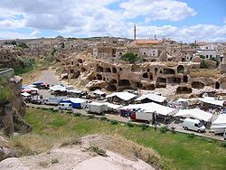
The most famous historical feature of Avanos, which is still relevant and very visible today, is its production of earthenware pottery, it is also the most economic activity in the town. The ceramic trade in this district and its countless pottery factories date right back to the Hittites
, and the ceramic clay from the red silt of the Kızılırmak has always been used. It is a popular destination because of its attractive old town with cobbled streets, and views over the river.
About 5 km (3 mi) from Avanos and 1 km (0.621372736649807 mi) from Paşabağları, the site of Zelve was founded on the steep northern slopes of Aktepe. Consisting of three separate valleys, the ruins of Zelve is the area in Cappadocia with the highest concentration of fairy chimneys. Here, they have particularly sharp points and thick trunks. It is not known exactly when people began living in the dwellings carved into the rock, a lifestyle also common to other places in the region such as Uçhisar, Göreme
, Cavuşin other than Zelve. What is known is that an important Christian
community lived in Zelve and it was the religious center of the area from the 9th to the 13th centuries, and the first religious seminars for priests were held in the vicinity.
This church is located alongside Göreme-Avanos road at a distance of 2.5 km (1.6 mi) leaving from Göreme
. The church's narthex
is missing. It has tunnel vaults, a high nave and 3 apses. It dates back to 964-965 AD.
It is located in the far left draw of the Güllüdere valley about 2 km (1 mi) from the village of Çavuşin. It was founded at the mouth of the draw on top of a steep slope.
The design of the nave is square with a flat ceiling and it has a single broad apse. The apse was added in the 9th or 10th century to the main structure dating back to the 6th - 7th century. There are 2 or 3 layers of frescoes in the apse which indicates that it was painted regularly. Symbols of Gospel authors are drawn symmetrically and are sitting on the right and left of an enthroned Jesus.
In the middle of the flat ceiling is the relief of a cross in the middle of a circle surrounded with palm leaves and garlands. This sort of relief most likely belongs to the Iconoclastic period. The people of the area had a great love for the cross and it continued to be used as a motif after the Iconoclastic era because it symbolized the "Holy Cross
" in Jerusalem.
 Located 14 km (9 mi) northeast of Avanos, this underground city
was built on the northern slopes of Mt. Idis in an area with lots of strata made up of volcanic granite. The extensive galleries of the city are spread out over a large area and connected to each another by tunnels. Unlike the underground cities in Kaymaklı
and Derinkuyu
, there are very narrow (5 cm) and long holes between the different levels of the city that used to provide communication between the different levels of the city. The ventilation of these neatly carved out rooms was provided by these holes when the city was sealed up against enemies.
The city was discovered in 1972 by the local muezzin and farmer Latif Acar, when trying to find out where the water disappeared to when tending to his crops. He first found an underground room which, when later excavated, revealed a whole city which housed an incredible 60,000 people for up to three months. A total of 10 floors were discovered, to a depth 40m, although now only four are open.
Unlike the other underground cities in this area, besides the rolling stone doors, there were holes above the tunnels used for dumping hot oil on the enemy. Similar to Kaymaklı
and Derinkuyu
, Özkonak has a ventilation system, a water well
, a winery and rolling stone doors.
Nevsehir Province
Nevşehir Province is a province in central Turkey with its capital in Nevşehir. It adjacent provinces are Kırşehir to the northwest, Aksaray to the southwest, Niğde to the south, Kayseri to the southeast, and Yozgat to the northeast. Nevşehir includes the area called Cappadocia - a very popular...
in the Central Anatolia region of Turkey
Turkey
Turkey , known officially as the Republic of Turkey , is a Eurasian country located in Western Asia and in East Thrace in Southeastern Europe...
, located 18 km (11 mi) north of Nevşehir
Nevsehir
Nevşehir, formerly Muşkara, , is a city and the capital district of Nevşehir Province in the Central Anatolia Region of Turkey. According to the 2010 census, population of the district is 117,890 of which 85,634 631 live in the city of Nevşehir...
, the capital city of the province. It is situated within the historic and touristic region of Cappadocia
Cappadocia
Cappadocia is a historical region in Central Anatolia, largely in Nevşehir Province.In the time of Herodotus, the Cappadocians were reported as occupying the whole region from Mount Taurus to the vicinity of the Euxine...
. According to 2000 census, population of the district is 35,145 of which 12,288 live in the town of Avanos. The district covers an area of 994 km² (384 sq mi), and the average elevation is 920 m (3,018 ft), with the highest point being Mt. İsmail Sivrisi at 1756 m (5,761 ft).
The old city of Avanos, whose name in ancient times was Venessa overlooks the longest river of Turkey, the Kızılırmak
Kizilirmak
-Geographical names in Turkey:* Kızılırmak River is the longest river of Anatolia* Kızılırmak, Çankırı, a district of Çankırı Province, Turkey...
(Red River), which also separates Avanos from the rest of Cappadocia.
The most famous historical feature of Avanos, which is still relevant and very visible today, is its production of earthenware pottery, it is also the most economic activity in the town. The ceramic trade in this district and its countless pottery factories date right back to the Hittites
Hittites
The Hittites were a Bronze Age people of Anatolia.They established a kingdom centered at Hattusa in north-central Anatolia c. the 18th century BC. The Hittite empire reached its height c...
, and the ceramic clay from the red silt of the Kızılırmak has always been used. It is a popular destination because of its attractive old town with cobbled streets, and views over the river.
Visitor's attractions
- Zelve
About 5 km (3 mi) from Avanos and 1 km (0.621372736649807 mi) from Paşabağları, the site of Zelve was founded on the steep northern slopes of Aktepe. Consisting of three separate valleys, the ruins of Zelve is the area in Cappadocia with the highest concentration of fairy chimneys. Here, they have particularly sharp points and thick trunks. It is not known exactly when people began living in the dwellings carved into the rock, a lifestyle also common to other places in the region such as Uçhisar, Göreme
Göreme
Göreme , located among the "fairy chimney" rock formations, is a town in Cappadocia, a historical region of Turkey. It is in the Nevşehir Province in Central Anatolia and has a population of around 2,500 people....
, Cavuşin other than Zelve. What is known is that an important Christian
Christianity
Christianity is a monotheistic religion based on the life and teachings of Jesus as presented in canonical gospels and other New Testament writings...
community lived in Zelve and it was the religious center of the area from the 9th to the 13th centuries, and the first religious seminars for priests were held in the vicinity.
- Çavuşin (Nicephorus Phocas) Church
This church is located alongside Göreme-Avanos road at a distance of 2.5 km (1.6 mi) leaving from Göreme
Göreme
Göreme , located among the "fairy chimney" rock formations, is a town in Cappadocia, a historical region of Turkey. It is in the Nevşehir Province in Central Anatolia and has a population of around 2,500 people....
. The church's narthex
Narthex
The narthex of a church is the entrance or lobby area, located at the end of the nave, at the far end from the church's main altar. Traditionally the narthex was a part of the church building, but was not considered part of the church proper...
is missing. It has tunnel vaults, a high nave and 3 apses. It dates back to 964-965 AD.
- Güllüdere (St. Agathangelus) Church
It is located in the far left draw of the Güllüdere valley about 2 km (1 mi) from the village of Çavuşin. It was founded at the mouth of the draw on top of a steep slope.
The design of the nave is square with a flat ceiling and it has a single broad apse. The apse was added in the 9th or 10th century to the main structure dating back to the 6th - 7th century. There are 2 or 3 layers of frescoes in the apse which indicates that it was painted regularly. Symbols of Gospel authors are drawn symmetrically and are sitting on the right and left of an enthroned Jesus.
In the middle of the flat ceiling is the relief of a cross in the middle of a circle surrounded with palm leaves and garlands. This sort of relief most likely belongs to the Iconoclastic period. The people of the area had a great love for the cross and it continued to be used as a motif after the Iconoclastic era because it symbolized the "Holy Cross
True Cross
The True Cross is the name for physical remnants which, by a Christian tradition, are believed to be from the cross upon which Jesus was crucified.According to post-Nicene historians, Socrates Scholasticus and others, the Empress Helena The True Cross is the name for physical remnants which, by a...
" in Jerusalem.
- Özkonak Underground CityÖzkonak Underground CityÖzkonak Underground City is an ancient city built on the northern slopes of Mt. Idis about 14 km northeast of Avanos in Turkey. The city has many strata made up of volcanic granite its larger areas are connected to each other by tunnels. Özkonak had a built in communication system of pipes to...
Underground city
An Underground city is a series of linked subterranean spaces that may provide a defensive refuge; a place for living, working or shopping; a transit system; mausolea; wine or storage cellars; cisterns or drainage channels; or several of these. The term may also refer to a network of tunnels that...
was built on the northern slopes of Mt. Idis in an area with lots of strata made up of volcanic granite. The extensive galleries of the city are spread out over a large area and connected to each another by tunnels. Unlike the underground cities in Kaymaklı
Kaymakli Underground City
Kaymaklı Underground City is contained within the citadel of Kaymaklı in the Central Anatolia Region of Turkey. First opened to tourists in 1964, the village is about 19 km from Nevşehir, on the Nevşehir-Niğde road. The ancient name was Enegup. The houses in the village are constructed around...
and Derinkuyu
Derinkuyu Underground City
Derinkuyu Underground City is an ancient multi-level underground city in the Derinkuyu district in Nevşehir Province, Turkey.With its eleven floors extending to a depth of approximately 85 m, it was large enough to shelter tens of thousands of people together with their livestock and food stores...
, there are very narrow (5 cm) and long holes between the different levels of the city that used to provide communication between the different levels of the city. The ventilation of these neatly carved out rooms was provided by these holes when the city was sealed up against enemies.
The city was discovered in 1972 by the local muezzin and farmer Latif Acar, when trying to find out where the water disappeared to when tending to his crops. He first found an underground room which, when later excavated, revealed a whole city which housed an incredible 60,000 people for up to three months. A total of 10 floors were discovered, to a depth 40m, although now only four are open.
Unlike the other underground cities in this area, besides the rolling stone doors, there were holes above the tunnels used for dumping hot oil on the enemy. Similar to Kaymaklı
Kaymakli Underground City
Kaymaklı Underground City is contained within the citadel of Kaymaklı in the Central Anatolia Region of Turkey. First opened to tourists in 1964, the village is about 19 km from Nevşehir, on the Nevşehir-Niğde road. The ancient name was Enegup. The houses in the village are constructed around...
and Derinkuyu
Derinkuyu Underground City
Derinkuyu Underground City is an ancient multi-level underground city in the Derinkuyu district in Nevşehir Province, Turkey.With its eleven floors extending to a depth of approximately 85 m, it was large enough to shelter tens of thousands of people together with their livestock and food stores...
, Özkonak has a ventilation system, a water well
Water well
A water well is an excavation or structure created in the ground by digging, driving, boring or drilling to access groundwater in underground aquifers. The well water is drawn by an electric submersible pump, a trash pump, a vertical turbine pump, a handpump or a mechanical pump...
, a winery and rolling stone doors.
See also
- Churches of Göreme, TurkeyChurches of Göreme, TurkeyGöreme is a district of the Nevşehir Province in Turkey. After the eruption of Mount Erciyes about 2,000 years ago, ash and lava formed soft rocks in the Cappadocia Region, covering a region of about 20,000 km2. The softer rock was eroded by wind and water, leaving the hard cap rock on top...
- Derinkuyu Underground CityDerinkuyu Underground CityDerinkuyu Underground City is an ancient multi-level underground city in the Derinkuyu district in Nevşehir Province, Turkey.With its eleven floors extending to a depth of approximately 85 m, it was large enough to shelter tens of thousands of people together with their livestock and food stores...
- Kaymaklı Underground CityKaymakli Underground CityKaymaklı Underground City is contained within the citadel of Kaymaklı in the Central Anatolia Region of Turkey. First opened to tourists in 1964, the village is about 19 km from Nevşehir, on the Nevşehir-Niğde road. The ancient name was Enegup. The houses in the village are constructed around...
- MokissosMokissosMokissos is the formal name for a now inactive Diocese of the Greek Orthodox Church.Mokissos was an ancient Byzantine city , located in western Cappadocia at the foot of what is now known as the Hasan Dag, southeast of Koloneia...