
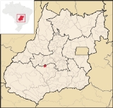
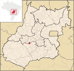
São João da Paraúna
Encyclopedia
| São João da Paraúna | |
|---|---|
| State | Goiás Goiás Goiás is a state of Brazil, located in the central part of the country. The name Goiás comes from the name of an indigenous community... |
| Area: | 305.3 km² |
| Population: | 1,699 (IBGE 2007) |
| Elevation: | 640 m above sea level |
| Postcode (CEP): | 75985-000 |
| IBGE statistical microregion: | 014 Vale do Rio dos Bois |
| Became a city: | 1989 |
| Distance to Goiânia Goiânia -Climate:The city has a tropical wet and dry climate with an average temperature of . There's a wet season, from October to April, and a dry one, from May to September. Annual rainfall is around 1,520 mm.... : |
143 km. |
| Website: | none |
Town
A town is a human settlement larger than a village but smaller than a city. The size a settlement must be in order to be called a "town" varies considerably in different parts of the world, so that, for example, many American "small towns" seem to British people to be no more than villages, while...
and municipality
Municipality
A municipality is essentially an urban administrative division having corporate status and usually powers of self-government. It can also be used to mean the governing body of a municipality. A municipality is a general-purpose administrative subdivision, as opposed to a special-purpose district...
in western Goiás
Goiás
Goiás is a state of Brazil, located in the central part of the country. The name Goiás comes from the name of an indigenous community...
state, Brazil
Brazil
Brazil , officially the Federative Republic of Brazil , is the largest country in South America. It is the world's fifth largest country, both by geographical area and by population with over 192 million people...
.
Location
São João is located west of GoiâniaGoiânia
-Climate:The city has a tropical wet and dry climate with an average temperature of . There's a wet season, from October to April, and a dry one, from May to September. Annual rainfall is around 1,520 mm....
, 36 km. north of Paraúna
Paraúna
Paraúna is a small town and municipality in southwestern Goiás state, Brazil. It has strange rock formations and is a large producer of cotton and soybeans.-Location:...
.
- Highway connections from GoiâniaGoiânia-Climate:The city has a tropical wet and dry climate with an average temperature of . There's a wet season, from October to April, and a dry one, from May to September. Annual rainfall is around 1,520 mm....
: state highway BR-069 west from GoiâniaGoiânia-Climate:The city has a tropical wet and dry climate with an average temperature of . There's a wet season, from October to April, and a dry one, from May to September. Annual rainfall is around 1,520 mm....
, through TrindadeTrindade-Transportation:Trindade are linked with São Tomé and Príncipe's only highways linking to the capital city of São Tomé, another linking Neves and Santana and another linking to Guadalupe as well....
, Santa Bárbara de GoiásSanta Bárbara de GoiásSanta Bárbara de Goiás is a small town and municipality in eastern Goiás state, Brazil.-Location:Santa Bárbara is located due west of Goiânia. Nearby towns are Trindade , and Nazário is 25 km...
, FirminópolisFirminópolisFirminópolis is a small town and municipality in eastern Goiás state, Brazil.-Location and connections:*Distance to São Luís de Montes Belos: 9 km....
, and then GO-164 for 32 kilometers south.
Neighboring municipalities: Aurilândia
Aurilândia
Aurilândia is a small town and municipality in eastern Goiás state, Brazil.-Location:The distance to the state capital is 146 km. while the distance to the main regional center São Luís de Montes Belos is 23 km....
, Paraúna
Paraúna
Paraúna is a small town and municipality in southwestern Goiás state, Brazil. It has strange rock formations and is a large producer of cotton and soybeans.-Location:...
, Palminópolis
Palminópolis
Palminópolis is a municipality in eastern Goiás state, Brazil.-Location:Nearby towns are Palmeiras de Goiás, 28 km. to the east, and Turvânia, 22 km. to the north...
, Jandaia
Jandaia
Jandaia is a small town and municipality in the eastern portion of the Brazilian state of Goiás.-Location and connections:Jandaia has municipal boundaries with:*Northwest: Palmeiras de Goiás*Northeast: Palminópolis...
, Acreúna
Acreúna
Acreúna is a small city and municipality in western Goiás state, Brazil.-Location:Acreúna is located in the statistical micro-region of Vale do Rio dos Bois, southwest of the state capital, Goiânia, on BR-060, which links Goiânia with Rio Verde...
.(Firminopolis),(São Luis dos Montes Belos)
Political information
- Mayor: Claudivino Ferreira da Silva (January 2005)
- City council: 09 members
- Eligible voters: 1,687 (December/2007)
Demographic information
- Population density: 5.56 inhab/km² (2007)
- Urban population: 1,212 (2007)
- Rural population: 487 (2007)
- Population growth: a gain of about 300 people since 1980
Economic information
The economy is based on subsistence agriculture, cattle raising, services, public administration, and small transformation industries.- Industrial units: 1 (2007)
- Commercial units: 17 (2007)
- Dairy: Laticínios MB Ltda (22/05/2006)
- Motor vehicles: 200 (2007), which gave a ratio of 8.5 inhabitants for each motor vehicle. (motorcycles and motorbikes not counted)
- Cattle herd: 30,500 head (5,190 milk cows) (2006)
- Main crops (2006): cotton), rice, beans, manioc, corn (1,340 hectares), and soybeans (2,900 hectares).
Data are from Sepin
Education (2006)
- Schools: 2
- Students: 453
- Higher education: none
- Adult literacy rate: 87.1% (2000) (national average was 86.4%)
Health (2003)
- Hospitals: 0
- Hospital beds: 0
- Ambulatory clinics: 2
- Infant mortality rate: 13.70 (2000) (national average was 33.0)
Municipal Human Development Index
Human Development Index
The Human Development Index is a composite statistic used to rank countries by level of "human development" and separate "very high human development", "high human development", "medium human development", and "low human development" countries...
- Life expectancy: 73.5
- School attendance rate: 0.837
- MHDI: 0.779
- State ranking: 34 (out of 242 municipalities in 2000)
- National ranking: 1,093 (out of 5,507 municipalities in 2000)
Data are from 2000
For the complete list see Frigoletto.com