
Au Sable Light
Encyclopedia
Au Sable Light is an active lighthouse
in the Pictured Rocks National Lakeshore
west of Grand Marais
, Michigan
off H-58
. Until 1910, this aid to navigation was called "Big Sable Light" (not to be confused with Big Sable Point Light
near Ludington, Michigan
on Lake Michigan
or Little Sable Point Light
south of Pentwater, Michigan
).
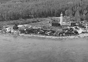
"shipwreck coast". The Au Sable Point reef
is a shallow ridge of sandstone that in places is only 6 feet (1.8 m) below the surface and extends nearly 1 miles (1.6 km) into Lake Superior. The Au Sable Point reef was one the greatest dangers facing ships coasting along the south shore of Lake Superior during the early shipping days when keeping land in sight was the main navigational method. The Au Sable Point reef was known as a "ship trap" that ensnared many ships, including the passenger ship Lady Elgin which was stranded there in 1859.
The shoreline in this area is considered one of North America's most beautiful, "but in the 1800s it was considered one of the most deadly because of unpredictable features below the surface and violent storms and blinding fogs above." The reef extends nearly a mile out as a ridge of sandstone a few feet below the surface. The shallow water caught many a vessel following the shore. Turbulence was common when the lake was "pushed in by violent storms out of the north and northwest." Thick fogs resulted form the mix of frigid lake air and warmth from the sand dunes. "As early as 1622, French explorers called the region 'most dangerous when there is any storms'."
Additionally, the location was chosen to eliminate a "dark spot" in the 80 mile stretch between Granite Island Light
and Whitefish Point Light.
The lighthouse tower and attached keepers' quarters were designed by Colonel Orlando Metcalfe Poe. In this capacity he designed eight "Poe style lighthouses" and oversaw construction of several. Poe was named District Engineer for the Eleventh Lighthouse District, Those lights are New Presque Isle Light (1870) on Lake Huron
, Lake Michigan
's South Manitou Island Light
(1872), Grosse Point Light
(1873) in Evanston, Illinois
, Lake Superior
's Au Sable Light (1874), Racine, Wisconsin
's Wind Point Light
(1880); Outer Island Light (1874) in the Apostle Islands
, Little Sable Point Light
(1874) on Lake Michigan, Manistique, Michigan
's Seul Choix Light
(1895) and Spectacle Reef Light
.
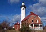
The tower is a white brick conical tower with a black lantern. A red brick lightkeeper's house stands next to the lighthouse. It originally had a third-order Fresnel lens
, which is now on display at the light station. The lighthouse was automated in 1958 and is currently equipped with a 300 mm solar-powered light.
A wooden boathouse was added in 1875; the fog signal building was added in 1897; the keepers' quarters were converted to a duplex in 1909; and the steel oil house was raised in 1915. There is also a second brick Keepers house (1909), a kerosene storage shed (1895), two brick outhouse
s (1874/1909), a wooden woodshed and boathouse
(1875), a brick cistern, and a two vehicle wood frame garage (1954). Most of these buildings are still extant; only one outhouse remains standing.
The keeper
's house was renovated. A visitor center is on the lower floor and an apartment for volunteer caretakers on the upper floor.
In 1996, the original Third Order Fresnel lens was returned to the tower after 39 years on display at the Pictured Rocks Nautical and Maritime Museum, also known as the Grand Marais Maritime Museum in Grand Marais. However, it is an external 300 mm lens that is operative.
The steam whistle
and airhorn have been removed. Nevertheless, the "boarded lantern area is an impressive sight."
The lighthouse tower is open to the public in summer. The complex was maintained by the National Park Service
, and the automated light continues to be operated by the United States Coast Guard
. The National Park Service's stated goal is to continue to maintain the lighthouse complex to its 1909-10 appearance, during its first year of operation as a two-person Lighthouse keeper
station.
The Light Station is part of the National Park Service's Pictured Rocks National Lakeshore. The Au Sable Light Station is on the National Register of Historic Places
, #78000374.
To visit this light, take H-58
H-58
from the Hurricane River Campground, which is 12 miles (19.3 km) west of Grand Marais, Michigan
. From the Campground the lighthouse is a 1.5 miles (2.4 km) walk on a sand trail.
Lighthouse
A lighthouse is a tower, building, or other type of structure designed to emit light from a system of lamps and lenses or, in older times, from a fire, and used as an aid to navigation for maritime pilots at sea or on inland waterways....
in the Pictured Rocks National Lakeshore
Pictured Rocks National Lakeshore
Pictured Rocks National Lakeshore is a U.S. National Lakeshore on the shore of Lake Superior in the Upper Peninsula of Michigan, United States. It extends for 42 miles along the shore and covers...
west of Grand Marais
Grand Marais, Michigan
Grand Marais is an unincorporated community in Burt Township, Alger County in the U.S. state of Michigan. It is located on Lake Superior at and is the eastern gateway to the Pictured Rocks National Lakeshore via H-58....
, Michigan
Michigan
Michigan is a U.S. state located in the Great Lakes Region of the United States of America. The name Michigan is the French form of the Ojibwa word mishigamaa, meaning "large water" or "large lake"....
off H-58
H-58 (Michigan county highway)
County Designated Highway H-58 is a road that runs east–west in the Upper Peninsula of Michigan. H-58 is routed through Pictured Rocks National Lakeshore. Along H-58, there are the towns of Melstrand, Van Meer, and Myren. The length is .The western terminus is at M-28 in downtown Munising,...
. Until 1910, this aid to navigation was called "Big Sable Light" (not to be confused with Big Sable Point Light
Big Sable Point Light
The Big Sable Point Light is a lighthouse on the eastern shore of Lake Michigan near Ludington in Mason County, Michigan, at the Ludington State Park. It is an active aid to navigation.-History:...
near Ludington, Michigan
Ludington, Michigan
Ludington is a city in the U.S. state of Michigan. As of the 2000 census, the city population was 8,357. It is the county seat of Mason County.Ludington is a harbor town located on Lake Michigan at the mouth of the Pere Marquette River...
on Lake Michigan
Lake Michigan
Lake Michigan is one of the five Great Lakes of North America and the only one located entirely within the United States. It is the second largest of the Great Lakes by volume and the third largest by surface area, after Lake Superior and Lake Huron...
or Little Sable Point Light
Little Sable Point Light
The Little Sable Point Light is a lighthouse located south of Pentwater in the lower peninsula of the U.S. state of Michigan. It is in the southwest corner of Golden Township, just south of Silver Lake State Park.The lighthouse was designed by Col. Orlando M...
south of Pentwater, Michigan
Pentwater, Michigan
Pentwater is a village in Oceana County in the U.S. state of Michigan. The population was 958 at the 2000 census. The village is located within Pentwater Township. Pentwater is home to Mears State Park. The name Pentwater comes from Pent or Penned up waters...
).
History
The Au Sable Light Station was built in 1874 on Au Sable Point, a well known hazard on Lake Superior'sLake Superior
Lake Superior is the largest of the five traditionally-demarcated Great Lakes of North America. It is bounded to the north by the Canadian province of Ontario and the U.S. state of Minnesota, and to the south by the U.S. states of Wisconsin and Michigan. It is the largest freshwater lake in the...
"shipwreck coast". The Au Sable Point reef
Reef
In nautical terminology, a reef is a rock, sandbar, or other feature lying beneath the surface of the water ....
is a shallow ridge of sandstone that in places is only 6 feet (1.8 m) below the surface and extends nearly 1 miles (1.6 km) into Lake Superior. The Au Sable Point reef was one the greatest dangers facing ships coasting along the south shore of Lake Superior during the early shipping days when keeping land in sight was the main navigational method. The Au Sable Point reef was known as a "ship trap" that ensnared many ships, including the passenger ship Lady Elgin which was stranded there in 1859.
The shoreline in this area is considered one of North America's most beautiful, "but in the 1800s it was considered one of the most deadly because of unpredictable features below the surface and violent storms and blinding fogs above." The reef extends nearly a mile out as a ridge of sandstone a few feet below the surface. The shallow water caught many a vessel following the shore. Turbulence was common when the lake was "pushed in by violent storms out of the north and northwest." Thick fogs resulted form the mix of frigid lake air and warmth from the sand dunes. "As early as 1622, French explorers called the region 'most dangerous when there is any storms'."
Additionally, the location was chosen to eliminate a "dark spot" in the 80 mile stretch between Granite Island Light
Granite Island (Michigan)
Granite Island is a 2½ acre island in Lake Superior located about northwest of Marquette in the Upper Peninsula of the U.S. state of Michigan. Posted upon it is the Granite Island Lighthouse, also known as Granite Island Light Station, and is "one of the oldest surviving lighthouses on Lake...
and Whitefish Point Light.
The lighthouse tower and attached keepers' quarters were designed by Colonel Orlando Metcalfe Poe. In this capacity he designed eight "Poe style lighthouses" and oversaw construction of several. Poe was named District Engineer for the Eleventh Lighthouse District, Those lights are New Presque Isle Light (1870) on Lake Huron
Lake Huron
Lake Huron is one of the five Great Lakes of North America. Hydrologically, it comprises the larger portion of Lake Michigan-Huron. It is bounded on the east by the Canadian province of Ontario and on the west by the state of Michigan in the United States...
, Lake Michigan
Lake Michigan
Lake Michigan is one of the five Great Lakes of North America and the only one located entirely within the United States. It is the second largest of the Great Lakes by volume and the third largest by surface area, after Lake Superior and Lake Huron...
's South Manitou Island Light
South Manitou Island Light
South Manitou Island Lighthouse is located on South Manitou Island in Lake Michigan, west of Leland, Michigan. It is in Leelanau County in western Northern Michigan.-History:This is the third lighthouse built on the island...
(1872), Grosse Point Light
Grosse Point Light
The historic Grosse Point Light is located in Evanston, Illinois. Following several shipping disasters near Evanston, residents successfully lobbied the federal government for a lighthouse. Construction was completed in 1873. The lighthouse was added to the National Register of Historic Places on...
(1873) in Evanston, Illinois
Evanston, Illinois
Evanston is a suburban municipality in Cook County, Illinois 12 miles north of downtown Chicago, bordering Chicago to the south, Skokie to the west, and Wilmette to the north, with an estimated population of 74,360 as of 2003. It is one of the North Shore communities that adjoin Lake Michigan...
, Lake Superior
Lake Superior
Lake Superior is the largest of the five traditionally-demarcated Great Lakes of North America. It is bounded to the north by the Canadian province of Ontario and the U.S. state of Minnesota, and to the south by the U.S. states of Wisconsin and Michigan. It is the largest freshwater lake in the...
's Au Sable Light (1874), Racine, Wisconsin
Racine, Wisconsin
Racine is a city in and the county seat of Racine County, Wisconsin, United States. According to 2008 U.S. Census Bureau estimates, the city had a population of 82,196...
's Wind Point Light
Wind Point Light
Wind Point Lighthouse is a lighthouse located at the north end of Racine Harbor in the U.S. state of Wisconsin. It is in the village of Wind Point, Wisconsin, on Lighthouse Road, next to the Shoop Park golf course. The lighthouse stands tall...
(1880); Outer Island Light (1874) in the Apostle Islands
Apostle Islands
The Apostle Islands are a group of 22 islands in Lake Superior, off the Bayfield Peninsula in northern Wisconsin. The majority of the islands are located in Ashland County—only Sand, York, Eagle, and Raspberry Islands are located in Bayfield County...
, Little Sable Point Light
Little Sable Point Light
The Little Sable Point Light is a lighthouse located south of Pentwater in the lower peninsula of the U.S. state of Michigan. It is in the southwest corner of Golden Township, just south of Silver Lake State Park.The lighthouse was designed by Col. Orlando M...
(1874) on Lake Michigan, Manistique, Michigan
Manistique, Michigan
Manistique is a city in the Upper Peninsula of the U.S. state of Michigan. As of the 2000 census, the city population was 3,583. It is the county seat of Schoolcraft County and the only incorporated community in the county. The city lies on the north shore of Lake Michigan, at the southwest corner...
's Seul Choix Light
Seul Choix Light
The Seul Choix Light is a lighthouse located in the northwest corner of Lake Michigan in Schoolcraft County, Michigan. The station was established in 1892 with a temporary light, and this light started service in 1895, and was fully automated in 1972. It is an active aid to navigation...
(1895) and Spectacle Reef Light
Spectacle Reef Light
Spectacle Reef Light is a lighthouse eleven miles east of the Straits of Mackinac and is located at the northern end of Lake Huron, Michigan. It was designed and built by Colonel Orlando Metcalfe Poe and Major Godfrey Weitzel, and was the most expensive lighthouse ever built on the Great Lakes...
.
The tower is a white brick conical tower with a black lantern. A red brick lightkeeper's house stands next to the lighthouse. It originally had a third-order Fresnel lens
Fresnel lens
A Fresnel lens is a type of lens originally developed by French physicist Augustin-Jean Fresnel for lighthouses.The design allows the construction of lenses of large aperture and short focal length without the mass and volume of material that would be required by a lens of conventional design...
, which is now on display at the light station. The lighthouse was automated in 1958 and is currently equipped with a 300 mm solar-powered light.
A wooden boathouse was added in 1875; the fog signal building was added in 1897; the keepers' quarters were converted to a duplex in 1909; and the steel oil house was raised in 1915. There is also a second brick Keepers house (1909), a kerosene storage shed (1895), two brick outhouse
Outhouse
An outhouse is a small structure separate from a main building which often contained a simple toilet and may possibly also be used for housing animals and storage.- Terminology :...
s (1874/1909), a wooden woodshed and boathouse
Boathouse
A boathouse is a building especially designed for the storage of boats, normally smaller craft for sports or leisure use. These are typically located on open water, such as on a river. Often the boats stored are rowing boats...
(1875), a brick cistern, and a two vehicle wood frame garage (1954). Most of these buildings are still extant; only one outhouse remains standing.
The keeper
Lighthouse keeper
A lighthouse keeper is the person responsible for tending and caring for a lighthouse, particularly the light and lens in the days when oil lamps and clockwork mechanisms were used. Keepers were needed to trim the wicks, replenish fuel, wind clockworks and perform maintenance tasks such as cleaning...
's house was renovated. A visitor center is on the lower floor and an apartment for volunteer caretakers on the upper floor.
In 1996, the original Third Order Fresnel lens was returned to the tower after 39 years on display at the Pictured Rocks Nautical and Maritime Museum, also known as the Grand Marais Maritime Museum in Grand Marais. However, it is an external 300 mm lens that is operative.
The steam whistle
Steam whistle
A steam whistle is a device used to produce sound with the aid of live steam, which acts as a vibrating system .- Operation :...
and airhorn have been removed. Nevertheless, the "boarded lantern area is an impressive sight."
The lighthouse tower is open to the public in summer. The complex was maintained by the National Park Service
National Park Service
The National Park Service is the U.S. federal agency that manages all national parks, many national monuments, and other conservation and historical properties with various title designations...
, and the automated light continues to be operated by the United States Coast Guard
United States Coast Guard
The United States Coast Guard is a branch of the United States Armed Forces and one of the seven U.S. uniformed services. The Coast Guard is a maritime, military, multi-mission service unique among the military branches for having a maritime law enforcement mission and a federal regulatory agency...
. The National Park Service's stated goal is to continue to maintain the lighthouse complex to its 1909-10 appearance, during its first year of operation as a two-person Lighthouse keeper
Lighthouse keeper
A lighthouse keeper is the person responsible for tending and caring for a lighthouse, particularly the light and lens in the days when oil lamps and clockwork mechanisms were used. Keepers were needed to trim the wicks, replenish fuel, wind clockworks and perform maintenance tasks such as cleaning...
station.
The Light Station is part of the National Park Service's Pictured Rocks National Lakeshore. The Au Sable Light Station is on the National Register of Historic Places
National Register of Historic Places
The National Register of Historic Places is the United States government's official list of districts, sites, buildings, structures, and objects deemed worthy of preservation...
, #78000374.
To visit this light, take
H-58H-58 (Michigan county highway)
County Designated Highway H-58 is a road that runs east–west in the Upper Peninsula of Michigan. H-58 is routed through Pictured Rocks National Lakeshore. Along H-58, there are the towns of Melstrand, Van Meer, and Myren. The length is .The western terminus is at M-28 in downtown Munising,...
from the Hurricane River Campground, which is 12 miles (19.3 km) west of Grand Marais, Michigan
Grand Marais, Michigan
Grand Marais is an unincorporated community in Burt Township, Alger County in the U.S. state of Michigan. It is located on Lake Superior at and is the eastern gateway to the Pictured Rocks National Lakeshore via H-58....
. From the Campground the lighthouse is a 1.5 miles (2.4 km) walk on a sand trail.
Specialized Further reading
- Terry Pepper, Seeing the Light, Au Sable Point Light at terrypepper.com.
- Taylor, Paul (October 2009) Orlando M. Poe: Civil War General and Great Lakes Engineer (Kent State University Press) ISBN 1606350404; ISBN 978-1606350409.
- Torres, Louis, Historic Structure Report, Pictured Rocks Au Sable Light Station (November, 1978).
External links
- Aerial photos, Au Sable Light, marinas.com.
- Exploring the North, Au Sable Point Light.
- Interactive map of lighthouses in eastern Lake Superior, powered by Google.
- National Park ServiceNational Park ServiceThe National Park Service is the U.S. federal agency that manages all national parks, many national monuments, and other conservation and historical properties with various title designations...
, Au Sable Point Light Station web page. - Photograph of the Au Sable Point Lighthouse and Lifesaving Station (ca. 1920), Michigan History, Arts and Libraries archive.
- Satellite view, Au Sable Point Light by Google mapsGoogle MapsGoogle Maps is a web mapping service application and technology provided by Google, free , that powers many map-based services, including the Google Maps website, Google Ride Finder, Google Transit, and maps embedded on third-party websites via the Google Maps API...
.