
Seul Choix Light
Encyclopedia
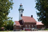
The Seul Choix Light is a lighthouse
located in the northwest corner of Lake Michigan
in Schoolcraft County, Michigan
. The station was established in 1892 with a temporary light, and this light started service in 1895, and was fully automated in 1972. It is an active aid to navigation. There is now a museum at the light and both the building and the grounds are open for visitors from Memorial Day until mid-October.
name is "only choice" so it is clear that it was used as a refuge by the early French traders in this area. Local references state that the correct pronunciation is "Sis-shwa", assumed to be the common name used by both the French Voyageurs and the Native Americans
with whom they traded furs.
In the 1880s, there was increased maritime traffic between the harbors on Lake Michigan's western shore and Green Bay on the one hand, and the Straits of Mackinac
on the other. Although the St. Helena Island Light marked the western entry into the Straits, and Poverty Island Light lighted the entrance to the Bays de Noc
, there were no lighthouses to aid mariners navigating a dark 100 miles (160.9 km) stretch of coastline on the southern shore of Michigan's Upper Peninsula. The navigation season along this shoreline often began and ended with treacherous storms. Waves would build as they traversed the lake, making shelter a matter of life and death. Thus, mariners would seek shelter on the leeward
side of points protruding into the lake along this stretch of unlighted shore.
The United States Lighthouse Board
sought to mark the sheltering harbor, and provide a visual waypoint
between the two existing lights. After considerable investigation and delay, the result was the building of this lighthouse . It also included a separate fog horn building, and a life saving station. Although it was built two decades later, the design of this light is similar to the Au Sable Light
which was designed by Orlando M. Poe, which also resembles the Grosse Point Light
The building is designed in Italianate architecture
.
During ten years of service as engineer for the Eleventh Lighthouse District, Colonel Poe designed eight lighthouses, namely: Presque Isle Light
(1870) on Lake Huron; Lake Michigan
’s South Manitou Island Light
(1872); Grosse Point Lighthouse (1873) in Evanston, Illinois
; Au Sable Light
(1874) on Lake Superior
; Wind Point Light
(1880) near Racine, Wisconsin
; Outer Island Light (1874) in the Apostle Islands
; Little Sable Point Light
(1874) on Lake Michigan, and Seul Choix Light near Manistique, Michigan
which completed in 1895; and his crowning achievement, Spectacle Reef Light
(1874). Others consider his "crowning achievement" to be the Poe Lock in Sault Ste. Marie, Michigan
.
The original optic was a fixed third-order Henry-LePaute Fresnel lens
. After its removal in 1973, it was housed in the Steamship Valley Camp
Museum in Sault Ste. Marie
, but is now in a private collection according to a sign in the keeper's dwelling.
When the light was automated,the original lens was removed and an aerobeacon was emplaced
The light was replaced with a DCB-224
aero beacon manufactured by the Carlisle & Finch
Company. In this configuration, its characteristic is a white flash every six seconds, which is visible for a distance of 17 nautical miles (31.5 km) in clear weather conditions, like the original lens. In 1973, the Coast Guard closed the station, and left the automated light unmanned. Putting aside questions of nostalgia, aesthetics, or appreciation for the engineering of a bygone era (as exemplified by the Fresnel lens), this iteration of lighthouse illumination is itself incredibly effective, and an endangered remnant of another bygone era.
The site includes two brick oil houses, a workshop, barn
, cistern
in lighthouse keeper
's house, converted boathouse
(now a garage), a second keepers house, two outhouse
s, and a dock.
On July 19, 1984, the site was listed in the National Register of Historic Places
, Reference #84001846 as Seul Choix Pointe Light Station (U.S. Coast Guard/Great
Lakes TR). In 1987 it was also listed on the state registry.
illustrations.
Folk singer
Carl Behrend recorded an album entitled "The Ballad of Seul Choix Lighthouse
.
It is open to the public and tours are available (including climbing the tower), which is "relatively rare for an active aid to navigation." On display are the fog signal and a very old dugout canoe which was found on site. There are also "unique copper moldings around some of the interior door frames .. . a [rare] decorative touch . . . in lighthouse dwellings."
The lighthouse is in the end stage its historical restoration, being performed by National Restoration, Inc.
Grounds are open year round, and the light and museum is open from Memorial Day
until October 15.
. From U.S. Route 2
in Gulliver, follow County Road 432 south about 4 miles (6.4 km) to County Road 431. Turn right (west) on CR-431 another 4 miles (6.4 km) to the park.
Lighthouse
A lighthouse is a tower, building, or other type of structure designed to emit light from a system of lamps and lenses or, in older times, from a fire, and used as an aid to navigation for maritime pilots at sea or on inland waterways....
located in the northwest corner of Lake Michigan
Lake Michigan
Lake Michigan is one of the five Great Lakes of North America and the only one located entirely within the United States. It is the second largest of the Great Lakes by volume and the third largest by surface area, after Lake Superior and Lake Huron...
in Schoolcraft County, Michigan
Schoolcraft County, Michigan
-National protected areas:* Hiawatha National Forest * Seney National Wildlife Refuge-Demographics:As of the census of 2000, there were 8,903 people, 3,606 households, and 2,498 families residing in the county. The population density was 8 people per square mile . There were 5,700 housing units...
. The station was established in 1892 with a temporary light, and this light started service in 1895, and was fully automated in 1972. It is an active aid to navigation. There is now a museum at the light and both the building and the grounds are open for visitors from Memorial Day until mid-October.
History
This location is the only harbor of refuge in a long and dangerous stretch of coast; the translation of the FrenchFrench language
French is a Romance language spoken as a first language in France, the Romandy region in Switzerland, Wallonia and Brussels in Belgium, Monaco, the regions of Quebec and Acadia in Canada, and by various communities elsewhere. Second-language speakers of French are distributed throughout many parts...
name is "only choice" so it is clear that it was used as a refuge by the early French traders in this area. Local references state that the correct pronunciation is "Sis-shwa", assumed to be the common name used by both the French Voyageurs and the Native Americans
Indigenous peoples of the Americas
The indigenous peoples of the Americas are the pre-Columbian inhabitants of North and South America, their descendants and other ethnic groups who are identified with those peoples. Indigenous peoples are known in Canada as Aboriginal peoples, and in the United States as Native Americans...
with whom they traded furs.
In the 1880s, there was increased maritime traffic between the harbors on Lake Michigan's western shore and Green Bay on the one hand, and the Straits of Mackinac
Straits of Mackinac
The Straits of Mackinac is the strip of water that connects two of the Great Lakes, Lake Michigan and Lake Huron, and separates the Lower Peninsula of Michigan from the Upper Peninsula of Michigan. It is a shipping lane providing passage for raw materials and finished goods, connecting, for...
on the other. Although the St. Helena Island Light marked the western entry into the Straits, and Poverty Island Light lighted the entrance to the Bays de Noc
Big Bay de Noc
Big Bay de Noc is a bay in the Upper Peninsula of the U.S. state of Michigan. The bay, which opens into Lake Michigan's Green Bay, is enclosed by Delta County...
, there were no lighthouses to aid mariners navigating a dark 100 miles (160.9 km) stretch of coastline on the southern shore of Michigan's Upper Peninsula. The navigation season along this shoreline often began and ended with treacherous storms. Waves would build as they traversed the lake, making shelter a matter of life and death. Thus, mariners would seek shelter on the leeward
Windward and leeward
Windward is the direction upwind from the point of reference. Leeward is the direction downwind from the point of reference. The side of a ship that is towards the leeward is its lee side. If the vessel is heeling under the pressure of the wind, this will be the "lower side"...
side of points protruding into the lake along this stretch of unlighted shore.
The United States Lighthouse Board
United States Lighthouse Board
The United States Lighthouse Board was the agency of the US Federal Government that was responsible for the upkeep and maintenance of all lighthouses in the United States...
sought to mark the sheltering harbor, and provide a visual waypoint
Waypoint
A waypoint is a reference point in physical space used for purposes of navigation.-Concept:Waypoints are sets of coordinates that identify a point in physical space. Coordinates used can vary depending on the application. For terrestrial navigation these coordinates can include longitude and...
between the two existing lights. After considerable investigation and delay, the result was the building of this lighthouse . It also included a separate fog horn building, and a life saving station. Although it was built two decades later, the design of this light is similar to the Au Sable Light
Au Sable Light
Au Sable Light is an active lighthouse in the Pictured Rocks National Lakeshore west of Grand Marais, Michigan off H-58. Until 1910, this aid to navigation was called "Big Sable Light" .-History:The Au Sable Light Station was built in 1874...
which was designed by Orlando M. Poe, which also resembles the Grosse Point Light
Grosse Point Light
The historic Grosse Point Light is located in Evanston, Illinois. Following several shipping disasters near Evanston, residents successfully lobbied the federal government for a lighthouse. Construction was completed in 1873. The lighthouse was added to the National Register of Historic Places on...
The building is designed in Italianate architecture
Italianate architecture
The Italianate style of architecture was a distinct 19th-century phase in the history of Classical architecture. In the Italianate style, the models and architectural vocabulary of 16th-century Italian Renaissance architecture, which had served as inspiration for both Palladianism and...
.
During ten years of service as engineer for the Eleventh Lighthouse District, Colonel Poe designed eight lighthouses, namely: Presque Isle Light
Presque Isle Light
The Presque Isle Light is one of the three lighthouses in Erie, Pennsylvania. It was built in 1872 and was listed on the National Register of Historic Places on August 4, 1983.- History :...
(1870) on Lake Huron; Lake Michigan
Lake Michigan
Lake Michigan is one of the five Great Lakes of North America and the only one located entirely within the United States. It is the second largest of the Great Lakes by volume and the third largest by surface area, after Lake Superior and Lake Huron...
’s South Manitou Island Light
South Manitou Island Light
South Manitou Island Lighthouse is located on South Manitou Island in Lake Michigan, west of Leland, Michigan. It is in Leelanau County in western Northern Michigan.-History:This is the third lighthouse built on the island...
(1872); Grosse Point Lighthouse (1873) in Evanston, Illinois
Evanston, Illinois
Evanston is a suburban municipality in Cook County, Illinois 12 miles north of downtown Chicago, bordering Chicago to the south, Skokie to the west, and Wilmette to the north, with an estimated population of 74,360 as of 2003. It is one of the North Shore communities that adjoin Lake Michigan...
; Au Sable Light
Au Sable Light
Au Sable Light is an active lighthouse in the Pictured Rocks National Lakeshore west of Grand Marais, Michigan off H-58. Until 1910, this aid to navigation was called "Big Sable Light" .-History:The Au Sable Light Station was built in 1874...
(1874) on Lake Superior
Lake Superior
Lake Superior is the largest of the five traditionally-demarcated Great Lakes of North America. It is bounded to the north by the Canadian province of Ontario and the U.S. state of Minnesota, and to the south by the U.S. states of Wisconsin and Michigan. It is the largest freshwater lake in the...
; Wind Point Light
Wind Point Light
Wind Point Lighthouse is a lighthouse located at the north end of Racine Harbor in the U.S. state of Wisconsin. It is in the village of Wind Point, Wisconsin, on Lighthouse Road, next to the Shoop Park golf course. The lighthouse stands tall...
(1880) near Racine, Wisconsin
Racine, Wisconsin
Racine is a city in and the county seat of Racine County, Wisconsin, United States. According to 2008 U.S. Census Bureau estimates, the city had a population of 82,196...
; Outer Island Light (1874) in the Apostle Islands
Apostle Islands
The Apostle Islands are a group of 22 islands in Lake Superior, off the Bayfield Peninsula in northern Wisconsin. The majority of the islands are located in Ashland County—only Sand, York, Eagle, and Raspberry Islands are located in Bayfield County...
; Little Sable Point Light
Little Sable Point Light
The Little Sable Point Light is a lighthouse located south of Pentwater in the lower peninsula of the U.S. state of Michigan. It is in the southwest corner of Golden Township, just south of Silver Lake State Park.The lighthouse was designed by Col. Orlando M...
(1874) on Lake Michigan, and Seul Choix Light near Manistique, Michigan
Manistique, Michigan
Manistique is a city in the Upper Peninsula of the U.S. state of Michigan. As of the 2000 census, the city population was 3,583. It is the county seat of Schoolcraft County and the only incorporated community in the county. The city lies on the north shore of Lake Michigan, at the southwest corner...
which completed in 1895; and his crowning achievement, Spectacle Reef Light
Spectacle Reef Light
Spectacle Reef Light is a lighthouse eleven miles east of the Straits of Mackinac and is located at the northern end of Lake Huron, Michigan. It was designed and built by Colonel Orlando Metcalfe Poe and Major Godfrey Weitzel, and was the most expensive lighthouse ever built on the Great Lakes...
(1874). Others consider his "crowning achievement" to be the Poe Lock in Sault Ste. Marie, Michigan
Sault Ste. Marie, Michigan
Sault Ste. Marie is a city in and the county seat of Chippewa County in the U.S. state of Michigan. It is in the north-eastern end of Michigan's Upper Peninsula, on the Canadian border, separated from its twin city of Sault Ste. Marie, Ontario, by the St. Marys River...
.
The original optic was a fixed third-order Henry-LePaute Fresnel lens
Fresnel lens
A Fresnel lens is a type of lens originally developed by French physicist Augustin-Jean Fresnel for lighthouses.The design allows the construction of lenses of large aperture and short focal length without the mass and volume of material that would be required by a lens of conventional design...
. After its removal in 1973, it was housed in the Steamship Valley Camp
Steamship Valley Camp
The SS Valley Camp is a freighter boat that served on the Great Lakes for almost 50 years and is currently serving as a museum ship in Sault Ste. Marie, Michigan.- History :...
Museum in Sault Ste. Marie
Sault Ste. Marie, Michigan
Sault Ste. Marie is a city in and the county seat of Chippewa County in the U.S. state of Michigan. It is in the north-eastern end of Michigan's Upper Peninsula, on the Canadian border, separated from its twin city of Sault Ste. Marie, Ontario, by the St. Marys River...
, but is now in a private collection according to a sign in the keeper's dwelling.
When the light was automated,the original lens was removed and an aerobeacon was emplaced
The light was replaced with a DCB-224
DCB-224
The model DCB-224 is a high-power spotlight designed and built by Carlisle & Finch. Originally intended for use use as an aero beacon, it was also widely used in marine lighthouses....
aero beacon manufactured by the Carlisle & Finch
Carlisle & Finch
Carlisle & Finch is a producer of nautical equipment and searchlights, and the inventor of the electric toy train. It is headquartered in Cincinnati, Ohio.-History :...
Company. In this configuration, its characteristic is a white flash every six seconds, which is visible for a distance of 17 nautical miles (31.5 km) in clear weather conditions, like the original lens. In 1973, the Coast Guard closed the station, and left the automated light unmanned. Putting aside questions of nostalgia, aesthetics, or appreciation for the engineering of a bygone era (as exemplified by the Fresnel lens), this iteration of lighthouse illumination is itself incredibly effective, and an endangered remnant of another bygone era.
The site includes two brick oil houses, a workshop, barn
Barn
A barn is an agricultural building used for storage and as a covered workplace. It may sometimes be used to house livestock or to store farming vehicles and equipment...
, cistern
Cistern
A cistern is a waterproof receptacle for holding liquids, usually water. Cisterns are often built to catch and store rainwater. Cisterns are distinguished from wells by their waterproof linings...
in lighthouse keeper
Lighthouse keeper
A lighthouse keeper is the person responsible for tending and caring for a lighthouse, particularly the light and lens in the days when oil lamps and clockwork mechanisms were used. Keepers were needed to trim the wicks, replenish fuel, wind clockworks and perform maintenance tasks such as cleaning...
's house, converted boathouse
Boathouse
A boathouse is a building especially designed for the storage of boats, normally smaller craft for sports or leisure use. These are typically located on open water, such as on a river. Often the boats stored are rowing boats...
(now a garage), a second keepers house, two outhouse
Outhouse
An outhouse is a small structure separate from a main building which often contained a simple toilet and may possibly also be used for housing animals and storage.- Terminology :...
s, and a dock.
On July 19, 1984, the site was listed in the National Register of Historic Places
National Register of Historic Places
The National Register of Historic Places is the United States government's official list of districts, sites, buildings, structures, and objects deemed worthy of preservation...
, Reference #84001846 as Seul Choix Pointe Light Station (U.S. Coast Guard/Great
Lakes TR). In 1987 it was also listed on the state registry.
Lighthouse in popular culture
The light is the subject of drawings, and even needlepointNeedlepoint
Needlepoint is a form of counted thread embroidery in which yarn is stitched through a stiff open weave canvas. Most needlepoint designs completely cover the canvas...
illustrations.
Folk singer
Folk Singer
Folk Singer is a 1964 album by Muddy Waters. Waters plays acoustic guitar, backed by Willie Dixon on string bass, Clifton James on drums, and Buddy Guy on acoustic guitar...
Carl Behrend recorded an album entitled "The Ballad of Seul Choix Lighthouse
Current status
The lighthouse is operated by the Gulliver Historical Society, in cooperation with the Michigan Department of Natural ResourcesMichigan Department of Natural Resources
The Michigan Department of Natural Resources is the agency of the state of Michigan charged with maintaining natural resources such as state parks, state forests, and recreation areas. It is governed by a director appointed by the Governor and accepted by the Natural Resources Commission...
.
It is open to the public and tours are available (including climbing the tower), which is "relatively rare for an active aid to navigation." On display are the fog signal and a very old dugout canoe which was found on site. There are also "unique copper moldings around some of the interior door frames .. . a [rare] decorative touch . . . in lighthouse dwellings."
The lighthouse is in the end stage its historical restoration, being performed by National Restoration, Inc.
Grounds are open year round, and the light and museum is open from Memorial Day
Memorial Day
Memorial Day is a United States federal holiday observed on the last Monday of May. Formerly known as Decoration Day, it originated after the American Civil War to commemorate the fallen Union soldiers of the Civil War...
until October 15.
Getting there
The light, located in a Michigan State Park near Gulliver, Michigan is about eleven miles (18 km) east of ManistiqueManistique, Michigan
Manistique is a city in the Upper Peninsula of the U.S. state of Michigan. As of the 2000 census, the city population was 3,583. It is the county seat of Schoolcraft County and the only incorporated community in the county. The city lies on the north shore of Lake Michigan, at the southwest corner...
. From U.S. Route 2
U.S. Route 2
U.S. Route 2 is an east–west U.S. Highway spanning across the northern continental United States. US 2 consists of two segments connected by various roadways in southern Canada...
in Gulliver, follow County Road 432 south about 4 miles (6.4 km) to County Road 431. Turn right (west) on CR-431 another 4 miles (6.4 km) to the park.
Specialized further reading
- http://www.uslhs.org/assets/resources/articles/seul_choix.pdfFischer, Jenifer. "Seul Choix Pointe Light Station." The Keeper's Log (United States Lighthouse SocietyUnited States Lighthouse SocietyThe United States Lighthouse Society is a non-profit organization dedicated to aiding in the restoration of American lighthouses and educating the public about their history. There are currently five chapters of the Society around the United States. Among other activities, it publishes The...
, Spring 2004), pp. 2–7.] - Hermanson, Don, True Lighthouse Hauntings, Revisited including Seul Choix Light (cover art).
- Perry, Terry, Seeing the Light, a full history of Seul Choix light.
- Taylor, Paul (October 2009) Orlando M. Poe: Civil War General and Great Lakes Engineer (Kent State University Press) ISBN 1606350404; ISBN 978-1606350409.
- Wobser, David; Woodward, James; and Shook, Jeff, Seul Choix Light, Boatnerd.com.