
Arleta, Los Angeles, California
Encyclopedia
Arleta is a district in the San Fernando Valley
region of the City of Los Angeles, California
. It was considered part of Pacoima
until the late 1960s, when the areas of Pacoima west of the Golden State Freeway (I-5) "seceded" and formed a new community area.
and North Hills
on the west, Sun Valley
on the east, Pacoima
on the southeast, Panorama City
on the south, and the City of San Fernando
on the north. It lies within the 6th City Council district.
The ZIP code for Arleta is 91331, the same as neighboring district Pacoima.
Arleta is accessible from the Golden State Freeway (I-5) and the Hollywood Freeway (SR 170). Major thoroughfares include Van Nuys Boulevard
, Woodman Avenue, Arleta Avenue, as well as Sheldon, Branford, Osborne and Terra Bella Streets. Metro Rapid route 761 provides fast transit on Van Nuys Boulevard, and Metro
route 158, goes up Woodman Avenue, but turns on Arleta Avenue via Brandford Street, and continues along Devonshire St into Granada Hills, Northridge, and Chatsworth, respectively.
The boundaries of Arleta are roughly Paxton Avenue on the northwest, Laurel Canyon Boulevard on the northeast, Tonopah Avenue on the southeast, and Woodman Avenue on the southwest, making the square area about four (4) miles, according to Google Earth
.
In 2009, the Los Angeles Times
s "Mapping L.A." project supplied these Arleta neighborhood statistics: population: 31,068; median household income: $65,649.
Rockabilly
singer Johnny Burnette
lived on Nordhoff Street and Woodman Avenue in the 1960s
.
Arleta was also the filming location for the fictitious McFly family in Back to the Future series. Homes on Roslyndale were modified for the decrepit future as well as the new & improved future, thanks to the wonders of time travel.
Arleta Post Office is located at 9454 Arleta Avenue. This post office was opened shortly before Christmas 1954 and has consistently served the community since then. The original construction was performed by Ralph Benton of Van Nuys at a total cost of $21,500.
 Arleta is served by the Los Angeles Unified School District
.
Public elementary schools include:
Pacoima Middle School serves Arleta.
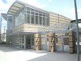
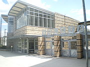
Arleta High School
opened in fall 2006.
Prior to the rezoning, the Arleta area was zoned to San Fernando High School
in the city of San Fernando
, and John H. Francis Polytechnic High School
in Sun Valley
.
San Fernando Valley
The San Fernando Valley is an urbanized valley located in the Los Angeles metropolitan area of southern California, United States, defined by the dramatic mountains of the Transverse Ranges circling it...
region of the City of Los Angeles, California
Los Angeles, California
Los Angeles , with a population at the 2010 United States Census of 3,792,621, is the most populous city in California, USA and the second most populous in the United States, after New York City. It has an area of , and is located in Southern California...
. It was considered part of Pacoima
Pacoima, Los Angeles, California
Pacoima is a district in the San Fernando Valley region of the city of Los Angeles, California.It is bordered by the Los Angeles districts of Mission Hills on the west, Arleta on the south, Sun Valley on the southeast, Lake View Terrace on the northeast, and by the city of San Fernando on the north...
until the late 1960s, when the areas of Pacoima west of the Golden State Freeway (I-5) "seceded" and formed a new community area.
Geography and transportation
Arleta is bordered by the Los Angeles districts of Mission HillsMission Hills, Los Angeles, California
Mission Hills is a suburban community in the San Fernando Valley region of the city of Los Angeles, California.It is located near the northern junction of the Golden State Freeway and the San Diego Freeway . The Ronald Reagan Freeway bisects the neighborhood. Mission Hills is the northern...
and North Hills
North Hills, Los Angeles, California
North Hills is a district in the San Fernando Valley region of the city of Los Angeles, California.North Hills is one of the oldest communities in the San Fernando Valley. Formerly known as Sepulveda, the community was renamed North Hills in 1992. Northridge is to the west, Panorama City is to the...
on the west, Sun Valley
Sun Valley, Los Angeles, California
Sun Valley is a district in the San Fernando Valley region of the city of Los Angeles, California, about 15 miles away from Downtown Los Angeles....
on the east, Pacoima
Pacoima, Los Angeles, California
Pacoima is a district in the San Fernando Valley region of the city of Los Angeles, California.It is bordered by the Los Angeles districts of Mission Hills on the west, Arleta on the south, Sun Valley on the southeast, Lake View Terrace on the northeast, and by the city of San Fernando on the north...
on the southeast, Panorama City
Panorama City, Los Angeles, California
Panorama City is a district in the San Fernando Valley region of the city of Los Angeles, California. It is known as the San Fernando Valley's first planned community.-Description:...
on the south, and the City of San Fernando
San Fernando, California
San Fernando is a city located in the San Fernando Valley, in northwestern region of Los Angeles, California, United States. The population was 23,645 at the 2010 census, up from 23,564 at the 2000 census.-History:...
on the north. It lies within the 6th City Council district.
The ZIP code for Arleta is 91331, the same as neighboring district Pacoima.
Arleta is accessible from the Golden State Freeway (I-5) and the Hollywood Freeway (SR 170). Major thoroughfares include Van Nuys Boulevard
Van Nuys Boulevard
Van Nuys Boulevard is a major north-south arterial road that runs through the central San Fernando Valley of Los Angeles County, California. The boulevard was notable for its cruising lifestyle that was prevalent in the 1960s and '70s, which was depicted in the 1979 film Van Nuys Blvd..-The...
, Woodman Avenue, Arleta Avenue, as well as Sheldon, Branford, Osborne and Terra Bella Streets. Metro Rapid route 761 provides fast transit on Van Nuys Boulevard, and Metro
Metro Local
Metro Local is a bus system in Los Angeles County operated by the Los Angeles County Metropolitan Transportation Authority . This retronym designation was placed to differentiate it from the Metro Rapid service...
route 158, goes up Woodman Avenue, but turns on Arleta Avenue via Brandford Street, and continues along Devonshire St into Granada Hills, Northridge, and Chatsworth, respectively.
The boundaries of Arleta are roughly Paxton Avenue on the northwest, Laurel Canyon Boulevard on the northeast, Tonopah Avenue on the southeast, and Woodman Avenue on the southwest, making the square area about four (4) miles, according to Google Earth
Google Earth
Google Earth is a virtual globe, map and geographical information program that was originally called EarthViewer 3D, and was created by Keyhole, Inc, a Central Intelligence Agency funded company acquired by Google in 2004 . It maps the Earth by the superimposition of images obtained from satellite...
.
Demographics
As of the census of 2000, there are 32,092 people in Arleta. The racial makeup of the district is 37.88% White (13.39% non-Latino white), 1.96% African American, 1.07% Native American, 11.72% Asian, 0.16% Pacific Islander, 42.41% from other races, and 4.80% from two or more races. 71.41% of the population are Hispanic or Latino of any race.In 2009, the Los Angeles Times
Los Angeles Times
The Los Angeles Times is a daily newspaper published in Los Angeles, California, since 1881. It was the second-largest metropolitan newspaper in circulation in the United States in 2008 and the fourth most widely distributed newspaper in the country....
s "Mapping L.A." project supplied these Arleta neighborhood statistics: population: 31,068; median household income: $65,649.
Famous residents
The Osmond Family maintained a home in the district in the early 1970s, for the family's use when it was working on projects in Hollywood. Their home, which still stands, is located on Nordhoff Street, right as that street begins at the intersection of Osborne Street.Rockabilly
Rockabilly
Rockabilly is one of the earliest styles of rock and roll music, dating to the early 1950s.The term rockabilly is a portmanteau of rock and hillbilly, the latter a reference to the country music that contributed strongly to the style's development...
singer Johnny Burnette
Johnny Burnette
John Joseph "Johnny" Burnette was an American rockabilly musician. Along with his older brother Dorsey Burnette, and also a friend named Paul Burlison, Burnette was a founding member of The Rock and Roll Trio. He was the father of 1980s rockabilly singer Rocky Burnette.-Early life:Johnny Burnette...
lived on Nordhoff Street and Woodman Avenue in the 1960s
1960s
The 1960s was the decade that started on January 1, 1960, and ended on December 31, 1969. It was the seventh decade of the 20th century.The 1960s term also refers to an era more often called The Sixties, denoting the complex of inter-related cultural and political trends across the globe...
.
Arleta was also the filming location for the fictitious McFly family in Back to the Future series. Homes on Roslyndale were modified for the decrepit future as well as the new & improved future, thanks to the wonders of time travel.
Government and infrastructure
The United States Postal ServiceUnited States Postal Service
The United States Postal Service is an independent agency of the United States government responsible for providing postal service in the United States...
Arleta Post Office is located at 9454 Arleta Avenue. This post office was opened shortly before Christmas 1954 and has consistently served the community since then. The original construction was performed by Ralph Benton of Van Nuys at a total cost of $21,500.
Parks and recreation
Branford Park is located in Arleta. The facility has an auditorium, a lighted baseball diamond, an unlighted baseball diamond, lighted outdoor basketball courts, a children's play area, a community room, an indoor gymnasium with weights, an indoor gymnasium without weights, an outdoor gymnasium without weights, a kitchen, a music room, picnic tables, a lighted soccer (football) field, a stage, lighted tennis courts, and lighted volleyball courts. In addition the Devonshire Arleta Park in Arleta.Public schools
Los Angeles Unified School District
Los Angeles Unified School District is the largest public school system in California. It is the 2nd largest public school district in the United States. Only the New York City Department of Education has a larger student population...
.
Public elementary schools include:
- Beachy Avenue Elementary School
- Canterbury Ave Elementary School
- Sharp Avenue Elementary School
- Vena Avenue Elementary School
Pacoima Middle School serves Arleta.
Arleta High School
Arleta High School
Arleta High School is a secondary school located on Van Nuys Boulevard in the Arleta section of Los Angeles, California in the San Fernando Valley....
opened in fall 2006.
Prior to the rezoning, the Arleta area was zoned to San Fernando High School
San Fernando High School
San Fernando High School, located in San Fernando, California, is a secondary school that is a part of the Los Angeles Unified School District....
in the city of San Fernando
San Fernando, California
San Fernando is a city located in the San Fernando Valley, in northwestern region of Los Angeles, California, United States. The population was 23,645 at the 2010 census, up from 23,564 at the 2000 census.-History:...
, and John H. Francis Polytechnic High School
John H. Francis Polytechnic High School
John H. Francis Polytechnic High School is a secondary school located in the Sun Valley area of Los Angeles, California. It serves grades 9 through 12 and is a part of the Los Angeles Unified School District...
in Sun Valley
Sun Valley, Los Angeles, California
Sun Valley is a district in the San Fernando Valley region of the city of Los Angeles, California, about 15 miles away from Downtown Los Angeles....
.
Private schools
Private schools include:- Osborne Christian School (K–12)
- Branford Grove (1-12)
- Arleta Christian School (K-8)