

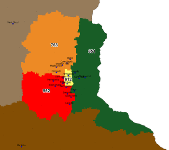
Area code 763
Encyclopedia
Telephone numbering plan
A telephone numbering plan is a type of numbering scheme used in telecommunications to allocate telephone numbers to subscribers and to route telephone calls in a telephone network. A closed numbering plan, such as found in North America, imposes a fixed total length to numbers...
code for the northwestern suburbs of Minneapolis-St. Paul, Minnesota
Minnesota
Minnesota is a U.S. state located in the Midwestern United States. The twelfth largest state of the U.S., it is the twenty-first most populous, with 5.3 million residents. Minnesota was carved out of the eastern half of the Minnesota Territory and admitted to the Union as the thirty-second state...
, including cities such as Plymouth
Plymouth, Minnesota
As of the census of 2000, there were 65,894 people, 24,820 households, and 17,647 families residing in the city. The population density was 2,002.0 persons per square mile . There were 25,258 housing units at an average density of 767.4 per square mile...
, Maple Grove
Maple Grove, Minnesota
As of the census of 2000, there were 50,365 people , 17,532 households, and 13,955 families residing in the city. The population density was 1,532.3 people per square mile . There were 17,745 housing units at an average density of 539.9 per square mile...
, and Brooklyn Park
Brooklyn Park, Minnesota
According to the 2010 census, there were 75,781 people residing in the city. The racial makeup of the city was 52% White, 24% African American, 1% Native American, 15% Asian, 42 residents identifying themselves as Pacific Islander, 4% from other races, and 4% from two or more races...
. It was created in 2000 along with area code 952
Area code 952
Area code 952 is the telephone numbering plan code in Minnesota for the southwestern suburbs of Minneapolis-St. Paul including cities such as Bloomington, Eden Prairie, Edina and Minnetonka...
(southwest suburbs) when they were carved out of area code 612
Area code 612
Area code 612 is the telephone numbering plan code for the city of Minneapolis, Minnesota and a few surrounding areas such as Fort Snelling, St. Anthony and Richfield. It is currently the smallest area code in the state by land area. However, the region used to be much larger, accounting for the...
, which now only contains the city of Minneapolis
Minneapolis, Minnesota
Minneapolis , nicknamed "City of Lakes" and the "Mill City," is the county seat of Hennepin County, the largest city in the U.S. state of Minnesota, and the 48th largest in the United States...
and a few inner-ring locales.
The area code splits in the Twin Cities are unusual - they split along municipal, rather than central office, boundaries. A sizeable number of exchanges are thus divided between two area codes, and a few are divided among three. http://areacode.ce-service.biz/ac763952C.htm
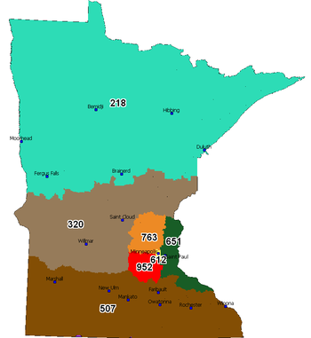
763 is bordered on the north and northwest by area code 320
Area code 320
Area code 320 is the telephone numbering plan code covering most of central Minnesota. It was the fourth Minnesota area code, created in 1996 when it was carved out of the former area code 612, which covered the state's midsection. The Twin Cities region retained 612, while the rest of the area...
, on the east by area code 651
Area code 651
Area code 651 is the telephone numbering plan code for Saint Paul, Minnesota, and the eastern suburbs of the Twin Cities. A dogleg portion also extends to the southeast along the Mississippi River to include cities such as Red Wing...
, and by area codes 952 and 612 to the south and southeast respectively.
Cities and Communities within Area code 763
|
Dayton, Minnesota Dayton is a city in Hennepin and Wright counties in the U.S. state of Minnesota. The population was 4,671 at the 2010 census. Dayton is mainly in Hennepin County, but a part of the city extends into Wright County as well. It is the northernmost city in Hennepin County.The city of Dayton, platted... Delano, Minnesota Delano is a city in Wright County, Minnesota, United States. The population was 5,464 at the 2010 census. It is part of the Twin Cities Metropolitan Statistical Area.-Geography:... East Bethel, Minnesota East Bethel is a city in Anoka County, Minnesota, United States. The population was 11,626 at the 2010 census.Minnesota State Highway 65 serves as a main arterial route in the city.-Geography:... Elk River, Minnesota As of the census of 2000, there were 16,447 people, 5,664 households, and 4,400 families residing in the city. Recent estimates show the population at 21,329 as of 2005. The population density was 385.5 people per square mile . There were 5,782 housing units at an average density of 135.5 per... Fridley, Minnesota As of the census of 2000, there were 27,449 people, 11,328 households, and 7,317 families residing in the city. The population density was 2,701.3 people per square mile . There were 11,504 housing units at an average density of 1,132.1 per square mile... Golden Valley, Minnesota As of the census of 2000, there were 20,281 people, 8,449 households, and 5,508 families residing in the city. The population density was 1,982.3 people per square mile . There were 8,589 housing units at an average density of 839.5 per square mile... Greenfield, Minnesota Greenfield is a city in Hennepin County, Minnesota, United States, along the Crow River. The population was 2,777 at the 2010 census.-Geography:... Ham Lake, Minnesota As of the census of 2000, there were 12,710 people, 4,139 households, and 3,472 families residing in the city. The population density was 368.9 people per square mile . There were 4,208 housing units at an average density of 122.1 per square mile... Hanover, Minnesota Hanover is a city in Hennepin and Wright counties in the U.S. state of Minnesota. The population was 2,938 at the 2010 census. Most of Hanover lies in Wright County; only a small part of the city extends into Hennepin County.... Independence, Minnesota Independence is a city in Hennepin County, Minnesota, United States. The population was 3,504 at the 2010 census. U.S. Route 12 serves as a main arterial route in the community.-Geography:... Isanti, Minnesota As of the census of 2000, there were 2,324 people, 816 households, and 576 families residing in the city. The population density was 1,095.3 people per square mile . There were 834 housing units at an average density of 393.1 per square mile... Lino Lakes, Minnesota As of the census of 2000, there were 16,791 people, 4,857 households, and 4,162 families residing in the city. The population density was 595.1 people per square mile . There were 4,921 housing units at an average density of 174.4 per square mile... Maple Grove, Minnesota As of the census of 2000, there were 50,365 people , 17,532 households, and 13,955 families residing in the city. The population density was 1,532.3 people per square mile . There were 17,745 housing units at an average density of 539.9 per square mile... Maple Plain, Minnesota As of the census of 2000, there were 2,088 people, 770 households, and 536 families residing in the city. The population density was 1,875.4 people per square mile . There were 786 housing units at an average density of 706.0 per square mile... Medicine Lake, Minnesota Medicine Lake is a city in Hennepin County, Minnesota, United States. The population was 371 at the 2010 census.-Geography:According to the United States Census Bureau, the city has a total area of —0.2 square miles of it is land and of it is water... Medina, Minnesota Medina is a city in Hennepin County, Minnesota, United States. The population was 4,892 at the 2010 census.-Geography:According to the United States Census Bureau, the city has a total area of , of which, of it is land and of it is water... |
Monticello, Minnesota Monticello is a city in Wright County, Minnesota, United States. Monticello was founded in 1856 and celebrated its 150th anniversary in 2006. The population was 12,759 at the 2010 census. The name Monticello is derived from the Italian word for "Little Mountain," it translates literally to... Montrose, Minnesota Montrose is a city in Wright County, Minnesota, United States. The population was 2,847 at the 2010 census.-Geography:According to the United States Census Bureau, the city has a total area of , of which, of it is land and 1.03% is water. U.S... Mounds View, Minnesota As of the census of 2000, there were 12,738 people, 5,018 households, and 3,387 families residing in the city. The population density was 3,096.6 people per square mile . There were 5,130 housing units at an average density of 1,247.1 per square mile... New Hope, Minnesota As of the census of 2000, there were 20,873 people, 8,665 households, and 5,268 families residing in the city. The population density was 4,098.6 people per square mile . There were 8,746 housing units at an average density of 1,717.4 per square mile... Oak Grove, Minnesota Oak Grove is a city in Anoka County, Minnesota, United States. It is north of Minneapolis. The population was 8,031 at the 2010 census. The city was formerly Oak Grove Township before it was incorporated on December 20, 1993.-History:... Osseo, Minnesota As of the census of 2000, there were 2,434 people, 1,035 households, and 606 families residing in the city. The population density was 3,179.7 people per square mile . There were 1,060 housing units at an average density of 1,384.7 per square mile... Plymouth, Minnesota As of the census of 2000, there were 65,894 people, 24,820 households, and 17,647 families residing in the city. The population density was 2,002.0 persons per square mile . There were 25,258 housing units at an average density of 767.4 per square mile... Princeton, Minnesota As of the census of 2000, there were 3,933 people, 1,624 households, and 998 families residing in the city. The population density was 887.7 people per square mile . There were 1,670 housing units at an average density of 376.9 per square mile... Ramsey, Minnesota As of the census of 2000, there were 18,510 people, 5,906 households, and 5,102 families residing in the city. The population density was 642.9 people per square mile . There were 5,946 housing units at an average density of 206.5 per square mile... Robbinsdale, Minnesota Robbinsdale is a city in Hennepin County, Minnesota, United States. The population was 13,953 at the 2010 census.-Geography:According to the United States Census Bureau, the city has a total area of , of which, of it is land and of it is water.... Rockford, Minnesota As of the census of 2000, there were 3,484 people, 1,296 households, and 929 families residing in the city. The population density was 2,021.2 people per square mile . There were 1,333 housing units at an average density of 773.3 per square mile... Rogers, Minnesota As of the census of 2000, there were 3,588 people, 1,195 households, and 982 families residing in the city. The population density was 715.1 people per square mile . There were 1,245 housing units at an average density of 248.1 per square mile... St. Francis, Minnesota As of the census of 2009, there were 7,298 people, 1,638 households, and 1,300 families residing in the city. The population density was 210.6 people per square mile . There were 1,686 housing units at an average density of 72.3 per square mile... St. Michael, Minnesota As of the census of 2000, there were 9,099 people, 2,926 households, and 2,437 families residing in the city. The population density was 279.4 people per square mile . There were 3,058 housing units at an average density of 93.9 per square mile... Spring Lake Park, Minnesota Spring Lake Park is a city in Anoka and Ramsey counties in the U.S. state of Minnesota. The population was 6,412 at the 2010 census. The city lies mainly in Anoka County.... Zimmerman, Minnesota Zimmerman is a rural community located about 45 miles northwest of St. Paul, in Sherburne County, Minnesota, United States. The population was 5,228 at the 2010 census.U.S. Route 169 serves as a main arterial route in the city.-History:... |