

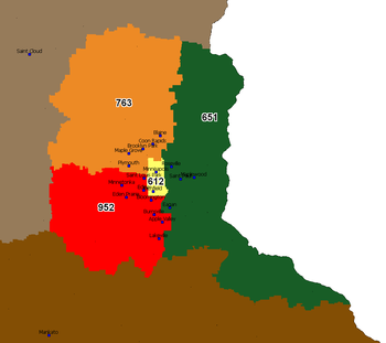
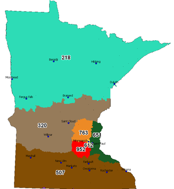
Area code 651
Encyclopedia
Telephone numbering plan
A telephone numbering plan is a type of numbering scheme used in telecommunications to allocate telephone numbers to subscribers and to route telephone calls in a telephone network. A closed numbering plan, such as found in North America, imposes a fixed total length to numbers...
code for Saint Paul, Minnesota
Saint Paul, Minnesota
Saint Paul is the capital and second-most populous city of the U.S. state of Minnesota. The city lies mostly on the east bank of the Mississippi River in the area surrounding its point of confluence with the Minnesota River, and adjoins Minneapolis, the state's largest city...
, and the eastern suburbs of the Twin Cities. A dogleg portion also extends to the southeast along the Mississippi River
Mississippi River
The Mississippi River is the largest river system in North America. Flowing entirely in the United States, this river rises in western Minnesota and meanders slowly southwards for to the Mississippi River Delta at the Gulf of Mexico. With its many tributaries, the Mississippi's watershed drains...
to include cities such as Red Wing
Red Wing, Minnesota
Red Wing is a city in Goodhue County, Minnesota, United States, on the Mississippi River. The population was 16,459 at the 2010 census. It is the county seat of Goodhue County....
. The region was the fifth area code created in the state in 1998, when it was carved out of area code 612
Area code 612
Area code 612 is the telephone numbering plan code for the city of Minneapolis, Minnesota and a few surrounding areas such as Fort Snelling, St. Anthony and Richfield. It is currently the smallest area code in the state by land area. However, the region used to be much larger, accounting for the...
.
The area code splits in the Twin Cities are unusual because they split along municipal, rather than central office, boundaries. This led to a sizeable number of exchanges being divided between two area codes, and a few being divided among three. http://areacode.ce-service.biz/ac763952C.htm http://www.lincmad.com/commentary.html
Cities and Communities within Area code 651
|
Lake City, Minnesota As of the census of 2000, there were 4,950 people, 2,131 households, and 1,402 families residing in the city. The population density was 1,166.9 people per square mile . There were 2,347 housing units at an average density of 553.3 per square mile... Lake Elmo, Minnesota As of the census of 2000, there were 6,863 people, 2,347 households, and 1,924 families residing in the city. The population density was 300.4 people per square mile . There were 2,389 housing units at an average density of 104.6 per square mile... Lakeland, Minnesota Lakeland is a city in Washington County, Minnesota, United States. The population was 1,796 at the 2010 census.-Geography:According to the United States Census Bureau, the city has a total area of , of which, of it is land and of it is water. Interstate 94 and Minnesota State Highway 95 are two... Lindstrom, Minnesota Lindström was settled predominantly by Swedish immigrants and their families. As of the census of 2000, there were 3,015 people, 1,225 households, and 855 families residing in the city. The population density was 1,332.1 people per square mile . There were 1,322 housing units at an average... Lino Lakes, Minnesota As of the census of 2000, there were 16,791 people, 4,857 households, and 4,162 families residing in the city. The population density was 595.1 people per square mile . There were 4,921 housing units at an average density of 174.4 per square mile... Little Canada, Minnesota As of the census of 2000, there were 9,771 people, 4,375 households, and 2,393 families residing in the city. The population density was 2,445.8 people per square mile . There were 4,471 housing units at an average density of 1,119.1 per square mile... Mahtomedi, Minnesota As of the census of 2000, there were 7,563 people, 2,503 households, and 2,027 families residing in the city. The population density was 2,095.4 people per square mile . There were 2,581 housing units at an average density of 715.1 per square mile... Maplewood, Minnesota As of the census of 2000, there were 34,947 people, 13,758 households, and 9,190 families residing in the city. The population density was 2,017.5 people per square mile . There were 14,004 housing units at an average density of 808.5 per square mile... Mendota Heights, Minnesota At the 2000 census, there were 11,434 people, 4,178 households and 3,237 families residing in the town. The population density was 1,222.2 per square mile . There were 4,252 housing units at an average density of 454.5 per square mile... Miesville, Minnesota Miesville is a city in Dakota County, Minnesota, United States. The population was 125 at the 2010 census.U.S. Highway 61 serves as a main route in the community... New Brighton, Minnesota As of the census of 2000, there were 22,206 people, 9,013 households, and 5,903 families residing in the city. The population density was 3,343.9 people per square mile . There were 9,121 housing units at an average density of 1,373.5 per square mile... New Trier, Minnesota New Trier is a city in Dakota County, Minnesota, United States. The population was 112 at the 2010 census. Minnesota Highway 50 serves as a main route in the community.-History:... Newport, Minnesota Newport is a city in Washington County, Minnesota, United States. The population was 3,435 at the 2010 census.-Geography:According to the United States Census Bureau, the city has a total area of , of which, of it is land and of it is water.... North Branch, Minnesota As of the census of 2000, there were 8,023 people, 2,815 households, and 2,147 families residing in the city. The population density was 224.9 people per square mile . There were 2,900 housing units at an average density of 81.3 per square mile... North Oaks, Minnesota North Oaks is a suburb north of Saint Paul in Ramsey County in the U.S. state of Minnesota. The population was 4,469 at the 2010 census.Formerly a gated community that now posts private access signage, all land is owned by homeowners with the North Oaks Home Owners Association maintaining all... North St. Paul, Minnesota North St. Paul is a city in Ramsey County, Minnesota, east of the city of Saint Paul. The population was 11,460 at the 2010 census.North St. Paul is a distinct city, and not a neighborhood of nearby St. Paul... Oak Park Heights, Minnesota Oak Park Heights is a city in Washington County, Minnesota, United States. The population was 4,339 at the 2010 census.-Geography:According to the United States Census Bureau, the city has a total area of , all land... Oakdale, Minnesota As of the census of 2000, there were 26,653 people, 10,243 households, and 7,129 families residing in the city. The population density was 2,408.4 people per square mile . There were 10,394 housing units at an average density of 939.2 per square mile... Saint Paul, Minnesota Saint Paul is the capital and second-most populous city of the U.S. state of Minnesota. The city lies mostly on the east bank of the Mississippi River in the area surrounding its point of confluence with the Minnesota River, and adjoins Minneapolis, the state's largest city... St. Paul Park, Minnesota St. Paul Park is a city in Washington County, Minnesota, United States. The population was 5,279 at the 2010 census. It is located on the Mississippi River five miles downstream from St... |
Shoreview, Minnesota As of the census of 2000, there are 25,377 people, Males: 12,303 , Females: 13,074 , 9,965 households, and 7,021 families residing in the city. The population density is 2,315.9 people per square mile . There are 10,127 housing units at an average density of 919.2 per square mile... South St. Paul, Minnesota South St. Paul is a city in Dakota County, Minnesota, immediately south and southeast of the city of Saint Paul, Minnesota. It is also southeast of West St. Paul, Minnesota. The population was 20,160 at the 2010 census. It is notable as one of the historic major meat packing cities in the United... Stacy, Minnesota Stacy is a city in Chisago County, Minnesota, United States, along the Sunrise River. The population was 1,456 at the 2010 census.Interstate 35 serves as a main arterial route for the community.-Geography:... Stillwater, Minnesota As of the census of 2000, there were 15,143 people, 5,797 households, and 4,115 families residing in the city. The population density was 2,340.0 people per square mile . There were 5,926 housing units at an average density of 915.7 per square mile... Taylors Falls, Minnesota As of the census of 2000, there were 951 people, 369 households, and 247 families residing in the city. The population density was 255.6 people per square mile . There were 386 housing units at an average density of 103.7 per square mile... Red Wing, Minnesota Red Wing is a city in Goodhue County, Minnesota, United States, on the Mississippi River. The population was 16,459 at the 2010 census. It is the county seat of Goodhue County.... Rosemount, Minnesota As of the census of 2000, there were 14,619 people, 4,742 households, and 3,931 families residing in the city. The population density was 434.2 people per square mile . There were 4,845 housing units at an average density of 143.9 per square mile... Roseville, Minnesota As of the census of 2000, there were 33,690 people, 14,598 households, and 8,598 families residing in the city. The population density was 2,543.9 people per square mile . There were 14,917 housing units at an average density of 1,126.4 per square mile... Vadnais Heights, Minnesota Vadnais Heights is a city in Ramsey County, Minnesota, United States. The population was 12,302 at the 2010 census.-Geography:According to the United States Census Bureau, the city has a total area of , of which, is land and is water. It borders the cities of Shoreview, Little Canada, White Bear... Vermillion, Minnesota Vermillion is a city in Dakota County, Minnesota, United States. The population was 419 at the 2010 census.-Geography:According to the United States Census Bureau, the city has a total area of , all of it land. County Roads 62, 66, and 85 are three of the main routes in the community. U.S... Wabasha, Minnesota As of the census of 2000, there were 2,599 people, 1,062 households, and 665 families residing in the city. The population density was 318.4 people per square mile . There were 1,166 housing units at an average density of 142.9 per square mile... West St. Paul, Minnesota As of the census of 2000, there were 19,405 people, 8,645 households, and 4,875 families residing in the city. The population density was 3,874.2 people per square mile . There were 8,779 housing units at an average density of 1,752.7 per square mile... White Bear Lake, Minnesota White Bear Lake is a city in Ramsey and Washington counties in the U.S. state of Minnesota. The population was 23,797 at the 2010 census. The city is located on White Bear Lake, one of the largest lakes in the Minneapolis-St... Withrow, Minnesota Withrow is an unincorporated village on the edge of the Minneapolis-St. Paul metropolitan area in the U.S. state of Minnesota. It was formally absorbed into the cities of Hugo, Grant and May Township in Washington County... Woodbury, Minnesota Woodbury is a city in Washington County, Minnesota, United States, and is a suburb of the Twin Cities metropolitan area. It is situated east of Saint Paul along Interstate 94... Wyoming, Minnesota As of the census of 2000, there were 3,048 people, 1,023 households, and 848 families residing in the city. The population density was 1,069.8 people per square mile . There were 1,055 housing units at an average density of 370.3 per square mile... |