
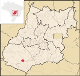
Aparecida do Rio Doce
Encyclopedia
| Aparecida do Rio Doce | |
|---|---|
| State | Goiás Goiás Goiás is a state of Brazil, located in the central part of the country. The name Goiás comes from the name of an indigenous community... |
| Coordinates: | 18°17′41"S 51°08′18"W |
| Area: | 290.0 km² |
| Population: | 2,702(IBGE 2007) |
| Elevation: | 549m |
| Postcode (CEP): | 75827-000 |
| IBGE statistical microregion: | 018 Sudoeste de Goiás |
| Became a city: | 1993 |
| Mayor: | Ilton Justino |
| Distance to Goiânia Goiânia -Climate:The city has a tropical wet and dry climate with an average temperature of . There's a wet season, from October to April, and a dry one, from May to September. Annual rainfall is around 1,520 mm.... : |
208 km. |
| Website: | n/a |
Town
A town is a human settlement larger than a village but smaller than a city. The size a settlement must be in order to be called a "town" varies considerably in different parts of the world, so that, for example, many American "small towns" seem to British people to be no more than villages, while...
and municipality
Municipality
A municipality is essentially an urban administrative division having corporate status and usually powers of self-government. It can also be used to mean the governing body of a municipality. A municipality is a general-purpose administrative subdivision, as opposed to a special-purpose district...
in southwest Goiás
Goiás
Goiás is a state of Brazil, located in the central part of the country. The name Goiás comes from the name of an indigenous community...
state, Brazil
Brazil
Brazil , officially the Federative Republic of Brazil , is the largest country in South America. It is the world's fifth largest country, both by geographical area and by population with over 192 million people...
.
Geography
The municipality of Aparecida do Rio Doce belongs to the Sudoeste de Goiás Microregion and is 208 km. from the state capital, GoiâniaGoiânia
-Climate:The city has a tropical wet and dry climate with an average temperature of . There's a wet season, from October to April, and a dry one, from May to September. Annual rainfall is around 1,520 mm....
. Connections are made by BR-060 / Guapó
Guapó
Guapó is a small town and municipality in central Goiás state, Brazil. The population was 13,586 and the total area of the municipality was 517.0 km² .Guapó is part of the Goiânia Microregion...
/ Indiara
Indiara
Indiara is a small city and municipality in central-south Goiás state, Brazil. Indiara is a large producer of soybeans and cotton.-Location:Indiara is located in the Vale do Rio dos Bois and has municipal boundaries with:*north: Palmeiras de Goiás...
/ Rio Verde
Rio Verde, Goiás
Rio Verde is a city and municipality in the Brazilian state of Goiás. It is a fast-growing center and is the largest producer of grains in the state.-Location:...
/ GO-174/ GO-422 / BR-364. The town lies at the junction of BR364 and GO174.
Belonging to the Paraná River
Paraná River
The Paraná River is a river in south Central South America, running through Brazil, Paraguay and Argentina for some . It is second in length only to the Amazon River among South American rivers. The name Paraná is an abbreviation of the phrase "para rehe onáva", which comes from the Tupi language...
basin, the river system is varied, with the most important rivers being the Rio Claro and its tributary, the Rio Doce. Along these rivers there are several small waterfalls, the most important being Salto do Rio Claro. The two rivers are used for recreational fishing and swimming by locals and tourists. Municipal boundaries are with Jataí
Jataí
Jataí is a municipality in southern Goiás state, Brazil. Its population was 88,048 in a total area of 7,174.2 km². Jataí is a major producer of agricultural products, including soybeans, rice, and corn. It has the largest herd of cattle in the state and is a large producer of poultry and...
, Rio Verde
Rio Verde, Goiás
Rio Verde is a city and municipality in the Brazilian state of Goiás. It is a fast-growing center and is the largest producer of grains in the state.-Location:...
, and Caçu
Caçu
Caçu is a small town and municipality in southwest Goiás state, Brazil.-Location:Caçu is part of the Quirinópolis Microregion. It is located 330 kilometers from the state capital, Goiânia and is crossed by highway GO-206, which links the city with Quirinópolis...
.
Demographics
- Population density: 4.49 inhab/km² (2007)
- Population in 1980: n/a
- Population in 2007: 2,702
- Urban population: 2,088 (2007)
- Rural population: 614. (2007)
- Population growth rate: 1.80% 1996/2007
The economy
The main economic activity is cattle raising for meat (59,000 head in 2006). Farming is secondary and is mainly subsistence, with farmers growing rice, corn, and soybeans. Another economic activity is production of poultry and pigs, due to the proximity of the important Perdigão Foods factory in Rio Verde, one of the largest agroindustrial complexes in the world.- Industrial units: 4
- Retail units: 52
- Dairies: AGROLUCAS Laticínios Ltda. (22/05/2006)
- GDP in 2005 (R$ 1,000.00): 25,312
- GDP per capita in 2005 (R$ 1.00): 9,282
Motor vehicles:
- Automobiles: 213
- Pickup trucks: 26
- Number of inhabitants per motor vehicle: 11
Main agricultural products in ha.(2006)
- rice: 300
- corn: 300
- soybeans: 600
Farm Data (2006)in ha.
- Number of farms: 146
- Total area: 63,807
- Area of permanent crops: 286
- Area of perennial crops: 968
- Area of natural pasture: 48,244
- Persons working in agriculture: 516 IBGE
Health and education
- Infant mortality rate: 1990—39.53; 2000—17.77
(IBGE 2002)
- Literacy rate: 1991—67.5%; 2000—84.2%
(IBGE 2004)
- MHDI: 0.754
- State ranking: 68 (out of 242 municipalities)
- National ranking: 1753 (out of 5507 municipalities)
History
The history of Aparecida do Rio Doce as a municipality is recent as it was elevated to city status in 1993. The name derives from the patron saint of Brazil, Our Lady Aparecida, and the most important river of the region, the Rio Doce, which limits the urban area on the south and flows north to south to eventually join the Rio Claro.See also
- List of municipalities in Goiás
- Microregions of Goiás