
Anzac Avenue
Encyclopedia
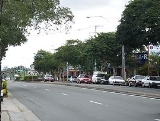
Anzac Avenue is a major arterial road north of Brisbane
, Queensland
. It runs 18 km from Petrie
to Redcliffe
, with most of the route signed as state route 71. The route was formerly the main route to the Redcliffe
peninsula, until the Houghton Highway
bridge was built.
The road provides the quickest access to the Peninsula Fair Shopping Centre, as well as being the main access road for the Redcliffe Hospital
.
intersection with state route 58 at Gympie Road and Dayboro Road. It proceeds north, then north-east, through Kallangur
, before crossing the Bruce Highway
near North Lakes
. After passing the Westfield North Lakes shopping centre, it proceeds north-east again through semi-rural areas near Mango Hill
, before crossing Hays Inlet
at Saltwater Creek, and intersecting with state route 26 at Deception Bay Road. Signed as both routes 71 and 26, it then turns eastward and proceeds through the suburbs of Rothwell
and Kippa-Ring
, reverting to route 71 only at an intersection with Elizabeth Avenue, before proceeding to Redcliffe, crossing state route 27 at Oxley Avenue, and terminating at a roundabout with Redcliffe Parade on the waterfront.
to Redcliffe, using part of the route of the current Anzac Avenue, but this road was poorly constructed and fell into disuse within a couple of years. Thomas Petrie
, in the 1870s, marked another track from Hays Inlet
to Redcliffe, this route was later surveyed and became known as "Brisbane Road", and became the primary way of accessing the Redcliffe Peninsula by road, although the trip was still difficult and all but impossible during inclement weather.
, memorials to fallen servicemen were erected across Queensland and often became prominent features in their communities. Utilitarian monuments, such as halls, hospitals, and roads became common, not just to commemorate war dead, but also to provide essential services to growing communities and provide work for returned soldiers. Anzac Avenue was one such project, built along a route first surveyed in the 1860s, designed to provide a reliable link to Redcliffe, which at the time was still largely isolated and could only be reached easily by boat, and not by car, which was rapidly becoming the transport method of choice for Queenslanders.
In 1922, Thomas Rothwell, a successful Brisbane businessman, and the RACQ, presented a plan to John Coyne, the Queensland Lands Minister, for the construction of a road between Petrie and Redcliffe. Coyne agreed to provide funding for the construction materials used on the road, provided that Rothwell and the RACQ could provide £20,000 for the payment of the returned soldiers who would build the road. To this end, Rothwell formed the Anzac Avenue Memorial Committee to secure the funds, and was elected as its chairman. Fundraising proceeded steadily, with a large billboard being erected on Queen Street in Brisbane, featuring a car that moved forward a step for every £1000 raised. The committee received a significant boost when a new federal government funding arrangement contributed £12,000 towards the effort. Within six months of beginning fundraising, the full amount had been raised and construction was ready to begin.
Construction activity proceeded rapidly; in December 1922 there were twenty-five returned servicemen employed constructing the road, by March of the following year, this number had increased to fifty. Work included not just sealing the road, using a mixture of tar and trachyte
sourced from a quarry at Beerburrum
, but also constructing culverts to cross over Hays Inlet
and Saltwater Creek, and associated earthworks to provide a stable base for the roadway in the often low-lying areas that the route passed through. The road was first opened to traffic in 1925 at a ceremony, at which Acting Premier William Forgan Smith
, Redcliffe mayor J. B. Dunn and Pine Rivers Shire Chairman W. Bradley spoke. The new road was the longest memorial avenue in Queensland.
Shortly after the road was opened, Rothwell wrote to local newspapers to draw attention to the tree planting work that would also be required before the plan came to fruition. As early as 1922, Rothwell and the assistant director of the Brisbane Botanic Gardens
, had been inspecting the route to come up with a suitable scheme for planting trees. The first planting, of two cocos palms
, took place in February 1925. By mid-1927, 1000 trees had been planted, and by November 1929 over 2000 trees had been established.
in 1935 providing an alternative route by car to the Redcliffe peninsula, traffic volumes along Anzac Avenue steadily increased as the years went by, necessitating duplication of some sections of the road in the 1980s and the 1990s. This widening, although required in order to manage traffic congestion, resulted in the need to remove or relocate some of the tree plantings along the route, a move that was not without controversy at the time.
Although originally primarily a rural route, increasing population growth in the area, most notably the development of entirely new suburbs such as Rothwell and North Lakes, has meant that much of the route has taken on a suburban character, providing everyday access to residents, rather than being a tourist drive, as originally planned. The road was inducted onto the Queensland Heritage Register in 2009.
- John Coyne,
Brisbane
Brisbane is the capital and most populous city in the Australian state of Queensland and the third most populous city in Australia. Brisbane's metropolitan area has a population of over 2 million, and the South East Queensland urban conurbation, centred around Brisbane, encompasses a population of...
, Queensland
Queensland
Queensland is a state of Australia, occupying the north-eastern section of the mainland continent. It is bordered by the Northern Territory, South Australia and New South Wales to the west, south-west and south respectively. To the east, Queensland is bordered by the Coral Sea and Pacific Ocean...
. It runs 18 km from Petrie
Petrie, Queensland
Petrie is a suburb north of Brisbane, Queensland, Australia. Its Local Government Area is the Moreton Bay Region. It is located in the North Pine River section of its local council 24 kilometres north of Brisbane City....
to Redcliffe
Redcliffe, Queensland
Redcliffe is a residential suburb of the Moreton Bay Region in the north-east of the Redcliffe peninsula, approximately north-northeast of Brisbane, the state capital of Queensland, Australia...
, with most of the route signed as state route 71. The route was formerly the main route to the Redcliffe
Redcliffe, Queensland
Redcliffe is a residential suburb of the Moreton Bay Region in the north-east of the Redcliffe peninsula, approximately north-northeast of Brisbane, the state capital of Queensland, Australia...
peninsula, until the Houghton Highway
Houghton Highway
The Houghton Highway is a reinforced concrete viaduct, shortening the road distance between the cities of Redcliffe and Brisbane in Queensland, Australia...
bridge was built.
The road provides the quickest access to the Peninsula Fair Shopping Centre, as well as being the main access road for the Redcliffe Hospital
Queensland Health
Queensland Health is the department of the Government of Queensland responsible for operating and administering the public health system of the Australian State of Queensland. It is responsible to the State's Health Minister Geoff Wilson and its Director-General is Tony O'Connell.Queensland Health...
.
Description
The current route begins in Petrie, at a roundaboutRoundabout
A roundabout is the name for a road junction in which traffic moves in one direction around a central island. The word dates from the early 20th century. Roundabouts are common in many countries around the world...
intersection with state route 58 at Gympie Road and Dayboro Road. It proceeds north, then north-east, through Kallangur
Kallangur, Queensland
Kallangur is a suburb north of Brisbane, the state capital of Queensland, Australia. Its Local Government Area is the Moreton Bay Region. The area once belonged to Mrs. Griffin of Whiteside located west of Petrie which was acquired by a Scottish migrant by the name of Thomas Petrie in 1855...
, before crossing the Bruce Highway
Bruce Highway
The Bruce Highway is a major highway in Queensland, Australia. Commencing in the state capital, Brisbane, it passes through areas close to the eastern coast to Cairns in Far North Queensland. The route is a part of the Australian National Highway and also part of Highway 1...
near North Lakes
North Lakes, Queensland
For North Lakes estate in New South Wales, see Cameron Park, New South Wales.North Lakes is a suburb north of Brisbane, Queensland, Australia. Its Local Government Area is the Moreton Bay Region. North Lakes is located approximately 25 km north of the Brisbane central business district...
. After passing the Westfield North Lakes shopping centre, it proceeds north-east again through semi-rural areas near Mango Hill
Mango Hill, Queensland
Mango Hill is a suburb north of Brisbane, Queensland, Australia. Its Local Government Area is the Moreton Bay Region.The area was named Mango Hill on 1 September 1980, after the mango trees lining Anzac Avenue as it passes through the area...
, before crossing Hays Inlet
Hays Inlet
Hays Inlet is a saltwater inlet off Bramble Bay in Queensland, Australia. The Brisway map reference is 420 L19. A mangrove forest is found in the inlet.-Geography:...
at Saltwater Creek, and intersecting with state route 26 at Deception Bay Road. Signed as both routes 71 and 26, it then turns eastward and proceeds through the suburbs of Rothwell
Rothwell, Queensland
Rothwell is a residential suburb of the Moreton Bay Region in the west of the Redcliffe peninsula, approximately north-northeast of Brisbane, the state capital of Queensland, Australia...
and Kippa-Ring
Kippa-Ring, Queensland
Kippa-Ring is a residential and light industrial suburb of the Moreton Bay Region at the center of the Redcliffe peninsula, approximately north-northeast of Brisbane, the state capital of Queensland, Australia.-History:...
, reverting to route 71 only at an intersection with Elizabeth Avenue, before proceeding to Redcliffe, crossing state route 27 at Oxley Avenue, and terminating at a roundabout with Redcliffe Parade on the waterfront.
Major intersections
Intersections are listed from west to east.| Location | Roads Intersected | Notes |
|---|---|---|
| Petrie | Gympie Road, Dayboro Road | , roundabout |
| Kallangur | Bruce Highway Bruce Highway The Bruce Highway is a major highway in Queensland, Australia. Commencing in the state capital, Brisbane, it passes through areas close to the eastern coast to Cairns in Far North Queensland. The route is a part of the Australian National Highway and also part of Highway 1... |
|
| Kippa-Ring | Deception Bay Road | , roundabout, route 26 continues east along Anzac Ave |
| Redcliffe | Elizabeth Avenue | , route 26 continues south along Elizabeth Ave |
| Redcliffe | Oxley Avenue | |
| Redcliffe | Redcliffe Parade, Marine Parade | Terminus |
Early history
The first road along the route was an Aboriginal track used to access Kippa Ring, then the site of a prominent bora ring. By the 1860s, a road had been constructed from Bald HillsBald Hills, Queensland
Bald Hills is the northernmost suburb of the Brisbane City Council in Queensland, Australia.Bald Hills is a largely residential suburb. It is mostly surrounded by bushland, but in the last few years some of the bush areas have been cleared to make way for new residential areas...
to Redcliffe, using part of the route of the current Anzac Avenue, but this road was poorly constructed and fell into disuse within a couple of years. Thomas Petrie
Thomas Petrie
Thomas Petrie was an Australian explorer, grazier and friend of Aboriginals.Petrie was born at Edinburgh, fourth son of Andrew Petrie and brother of John. His family travelled to Sydney, arriving in October 1831 and his father entered the government service as a supervisor of building...
, in the 1870s, marked another track from Hays Inlet
Hays Inlet
Hays Inlet is a saltwater inlet off Bramble Bay in Queensland, Australia. The Brisway map reference is 420 L19. A mangrove forest is found in the inlet.-Geography:...
to Redcliffe, this route was later surveyed and became known as "Brisbane Road", and became the primary way of accessing the Redcliffe Peninsula by road, although the trip was still difficult and all but impossible during inclement weather.
Memorial avenue
After the First World WarWorld War I
World War I , which was predominantly called the World War or the Great War from its occurrence until 1939, and the First World War or World War I thereafter, was a major war centred in Europe that began on 28 July 1914 and lasted until 11 November 1918...
, memorials to fallen servicemen were erected across Queensland and often became prominent features in their communities. Utilitarian monuments, such as halls, hospitals, and roads became common, not just to commemorate war dead, but also to provide essential services to growing communities and provide work for returned soldiers. Anzac Avenue was one such project, built along a route first surveyed in the 1860s, designed to provide a reliable link to Redcliffe, which at the time was still largely isolated and could only be reached easily by boat, and not by car, which was rapidly becoming the transport method of choice for Queenslanders.
In 1922, Thomas Rothwell, a successful Brisbane businessman, and the RACQ, presented a plan to John Coyne, the Queensland Lands Minister, for the construction of a road between Petrie and Redcliffe. Coyne agreed to provide funding for the construction materials used on the road, provided that Rothwell and the RACQ could provide £20,000 for the payment of the returned soldiers who would build the road. To this end, Rothwell formed the Anzac Avenue Memorial Committee to secure the funds, and was elected as its chairman. Fundraising proceeded steadily, with a large billboard being erected on Queen Street in Brisbane, featuring a car that moved forward a step for every £1000 raised. The committee received a significant boost when a new federal government funding arrangement contributed £12,000 towards the effort. Within six months of beginning fundraising, the full amount had been raised and construction was ready to begin.
Construction activity proceeded rapidly; in December 1922 there were twenty-five returned servicemen employed constructing the road, by March of the following year, this number had increased to fifty. Work included not just sealing the road, using a mixture of tar and trachyte
Trachyte
Trachyte is an igneous volcanic rock with an aphanitic to porphyritic texture. The mineral assemblage consists of essential alkali feldspar; relatively minor plagioclase and quartz or a feldspathoid such as nepheline may also be present....
sourced from a quarry at Beerburrum
Beerburrum, Queensland
Beerburrum is a small town in South-East Queensland, Australia. It is located close to the Glass House Mountains 60 km north of the state capital, Brisbane, in the Sunshine Coast local government area. The name is derived from that of a nearby mountain, Mount Beerburrum: in the language of the...
, but also constructing culverts to cross over Hays Inlet
Hays Inlet
Hays Inlet is a saltwater inlet off Bramble Bay in Queensland, Australia. The Brisway map reference is 420 L19. A mangrove forest is found in the inlet.-Geography:...
and Saltwater Creek, and associated earthworks to provide a stable base for the roadway in the often low-lying areas that the route passed through. The road was first opened to traffic in 1925 at a ceremony, at which Acting Premier William Forgan Smith
William Forgan Smith
William Forgan Smith , generally known as Forgan Smith, was Premier of the Australian state of Queensland from 1932 to 1942. He came to dominate politics in the state during the 1930s, and his populism, firm leadership, defence of states' rights and interest in state development make him something...
, Redcliffe mayor J. B. Dunn and Pine Rivers Shire Chairman W. Bradley spoke. The new road was the longest memorial avenue in Queensland.
Shortly after the road was opened, Rothwell wrote to local newspapers to draw attention to the tree planting work that would also be required before the plan came to fruition. As early as 1922, Rothwell and the assistant director of the Brisbane Botanic Gardens
Brisbane Botanic Gardens
There are two major botanic gardens in Brisbane, Australia:*The Brisbane City Botanic Gardens are located in the south-east of the peninsula of the Brisbane River that contains the central business district of the city...
, had been inspecting the route to come up with a suitable scheme for planting trees. The first planting, of two cocos palms
Syagrus romanzoffiana
Syagrus romanzoffiana is a palm native to South America, from northern Argentina north to eastern Brazil and west to eastern Bolivia. It is very similar to the coconut palm. It had been classified within the Cocos genus as Cocos plumosa, was assigned to Arecastrum, then moved to Syagrus...
, took place in February 1925. By mid-1927, 1000 trees had been planted, and by November 1929 over 2000 trees had been established.
Recent history
Despite the construction of the Hornibrook BridgeHornibrook Bridge
Hornibrook Bridge was one of three bridges that crossed Bramble Bay, Queensland, Australia. The second is the Houghton Highway, which was built to accommodate rising traffic levels on the two-lane Hornibrook Bridge in the 1970s to increase capacity and cope with future demand...
in 1935 providing an alternative route by car to the Redcliffe peninsula, traffic volumes along Anzac Avenue steadily increased as the years went by, necessitating duplication of some sections of the road in the 1980s and the 1990s. This widening, although required in order to manage traffic congestion, resulted in the need to remove or relocate some of the tree plantings along the route, a move that was not without controversy at the time.
Although originally primarily a rural route, increasing population growth in the area, most notably the development of entirely new suburbs such as Rothwell and North Lakes, has meant that much of the route has taken on a suburban character, providing everyday access to residents, rather than being a tourist drive, as originally planned. The road was inducted onto the Queensland Heritage Register in 2009.
Plantings
A number of different types of tree were selected by the Anzac Avenue Memorial Committee to be placed along the roadside. These included:- Slash Pines (Pinus elliottii)
- Norfolk Island Pines (Araucaria heterophyllaAraucaria heterophyllaAraucaria heterophylla is a distinctive conifer, a member of the ancient and now disjointly distributed family Araucariaceae. As its vernacular name Norfolk Island Pine implies, the tree is endemic to Norfolk Island, a small island in the Pacific Ocean between Australia, New Zealand and New...
) - Mango Trees (Mangifera indicaMangifera indicaMangifera indica is a species of mango in the Anacardiaceae family. It is found in the wild in India and cultivated varieties have been introduced to other warm regions of the world...
) - Firewheel Trees (Stenocarpus sinuatusStenocarpus sinuatusStenocarpus sinuatus, known as the Firewheel Tree is an Australian rainforest tree in the Protea family. The range of natural distribution is in various rainforest types from the Nambucca River in New South Wales to the Atherton Tableland in tropical Queensland...
)
See also
Members of the Queensland Legislative Assembly, 1923–1926Members of the Queensland Legislative Assembly, 1923–1926
This is a list of members of the Queensland Legislative Assembly from 1923 to 1926, as elected at the 1923 state election. During the term, the United Party and the Country Party merged to form the Country and Progressive National Party, which became the main conservative party until the late...
- John Coyne,