

Antarctic Bottom Water
Encyclopedia
Water mass
An oceanographic water mass is an identifiable body of water with a common formation history which has physical properties distinct from surrounding water...
in the seas
Southern Ocean
The Southern Ocean comprises the southernmost waters of the World Ocean, generally taken to be south of 60°S latitude and encircling Antarctica. It is usually regarded as the fourth-largest of the five principal oceanic divisions...
surrounding Antarctica with temperatures ranging from 0 to -0.8◦ C, salinities
Salinity
Salinity is the saltiness or dissolved salt content of a body of water. It is a general term used to describe the levels of different salts such as sodium chloride, magnesium and calcium sulfates, and bicarbonates...
from 34.6 to 34.7 psu
PSU
The initialism PSU often refers to a Power supply unit, or specifically a computer's Power supply unit .The PSU powers all the computer's main components. There are many different PSUs that can come with anywhere up to 1500 watts for a standard desktop computer. The PSU is also sometimes referred...
, and a density near 27.88. Compared to other water masses, AABW is characteristically cold and fresh.
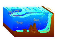
AABW is formed in the Weddell
Weddell Sea
The Weddell Sea is part of the Southern Ocean and contains the Weddell Gyre. Its land boundaries are defined by the bay formed from the coasts of Coats Land and the Antarctic Peninsula. The easternmost point is Cape Norvegia at Princess Martha Coast, Queen Maud Land. To the east of Cape Norvegia is...
and Ross Sea
Ross Sea
The Ross Sea is a deep bay of the Southern Ocean in Antarctica between Victoria Land and Marie Byrd Land.-Description:The Ross Sea was discovered by James Ross in 1841. In the west of the Ross Sea is Ross Island with the Mt. Erebus volcano, in the east Roosevelt Island. The southern part is covered...
s from surface water cooling in polynya
Polynya
A polynya or polynia is an area of open water surrounded by sea ice. It is now used as geographical term for an area of unfrozen sea within the ice pack. It is a loanword from , , which means a natural ice hole, and was adopted in the 19th century by polar explorers to describe navigable...
s and below the ice shelf
Ice shelf
An ice shelf is a thick, floating platform of ice that forms where a glacier or ice sheet flows down to a coastline and onto the ocean surface. Ice shelves are only found in Antarctica, Greenland and Canada. The boundary between the floating ice shelf and the grounded ice that feeds it is called...
. Surface water is enriched in salt from sea ice formation. Due to its increased density, the water is flowing down the Antarctic continental margin
Continental margin
The continental margin is the zone of the ocean floor that separates the thin oceanic crust from thick continental crust. Continental margins constitute about 28% of the oceanic area....
and on the bottom further north. It is the densest water in the free ocean and is overlain by the waters of the Antarctic Circumpolar Current
Antarctic Circumpolar Current
The Antarctic Circumpolar Current is an ocean current that flows from west to east around Antarctica. An alternative name for the ACC is the West Wind Drift. The ACC is the dominant circulation feature of the Southern Ocean and, at approximately 125 Sverdrups, the largest ocean current...
(AACW) at a depth of 1000 to 2000 m and overlies Weddell Sea Bottom Water (WSBW) in some locations.
About one-third of the northward flowing AABW enters the Guiana Basin, mainly through the southern half of the Equatorial Channel at 35°W. The other part recirculates and some of it flows through the Romanche Fracture Zone into the eastern Atlantic. In the Guiana Basin, west of 40°W, the sloping topography and the strong, eastward flowing deep western boundary current might prevent the AABW from flowing west: thus it has to turn north at the eastern slope of the Ceara Rise. At 44°W, north of the Ceara Rise, AABW flows west in the interior of the basin. A large fraction of the AABW enters the eastern Atlantic
Atlantic Ocean
The Atlantic Ocean is the second-largest of the world's oceanic divisions. With a total area of about , it covers approximately 20% of the Earth's surface and about 26% of its water surface area...
through the Vema Fracture Zone.