
Amphoe Phop Phra
Encyclopedia
Phop Phra is a district (Amphoe
) in the southwestern part of Tak Province
, northern Thailand
.
, Wang Chao of Tak Province, Ban Rai
of Uthai Thani Province
, Umphang
of Tak Province again and Kayin State
of Myanmar
.
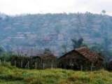
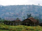
The Namtok Pha Charoen National Park is located in the district. The park is known for its Pha Charoen waterfall with 97 small levels.
The important river of Phop Pra is the Moei River
.
 Along Mae Sot-Umphang Highway is a refugee center Ban Um Piam (บ้านอุ้มเปี่ยม). It houses Karen
fled from Myanmar. They were relocated from the camp in Mae Sot close to Thai-Myanmar border which risked being attacked by guerrillas Democratic Karen Buddhist Army
from Myanmar.
), which are further subdivided into 52 villages (muban
). Phop Phra is a township (thesaban tambon), which covers parts of the tambon Phop Phra.
Amphoe
An amphoe is the second level administrative subdivision of Thailand. Usually translated as district, amphoe make up the provinces, and are analogous to a county seat...
) in the southwestern part of Tak Province
Tak Province
Tak is one of the northern provinces of Thailand. Neighboring provinces are Mae Hong Son, Chiang Mai, Lamphun, Lampang, Sukhothai, Kamphaeng Phet, Nakhon Sawan, Uthai Thani and Kanchanaburi...
, northern Thailand
Thailand
Thailand , officially the Kingdom of Thailand , formerly known as Siam , is a country located at the centre of the Indochina peninsula and Southeast Asia. It is bordered to the north by Burma and Laos, to the east by Laos and Cambodia, to the south by the Gulf of Thailand and Malaysia, and to the...
.
History
The whole area of Phop Phra was originally Tambon Chong Khaep of Mae Sot district. Due to the large size of Mae Sot and problems with communist insurgents, the government created a separate administration of the area. Effective April 1 1977 the three tambon Phop Phra, Chong Khaep and Khiri Rat formed the new minor district (King Amphoe). It was officially upgraded to a full district on March 3, 1987.Etymology
The name Phop Phra means Lord Buddha image discovery. Originally the area was named Pho Pha (เพอะพะ), which in Karen language that means swamp area, so the name was changed to have a better meaning.Geography
Neighboring districts are (from the north clockwise) Mae Sot, Mueang TakAmphoe Mueang Tak
Mueang Tak is the capital district of Tak Province, northern Thailand.-History:In Sukhothai era, Mueang Tak was the western frontier city. The old location of the city was in Tambon Ko Taphao, now Ban Tak district. It was moved because its old location was not strategically good. Another old city...
, Wang Chao of Tak Province, Ban Rai
Amphoe Ban Rai
Ban Rai is a district in the Uthai Thani Province in western Thailand.-Geography:The district covers more than half of the whole province Uthai Thani, and is also the third-largest district of Thailand areawise...
of Uthai Thani Province
Uthai Thani Province
Uthai Thani is one of the provinces of Thailand. Neighboring provinces are Nakhon Sawan, Chai Nat, Suphan Buri, Kanchanaburi and Tak.-Geography:...
, Umphang
Amphoe Umphang
Umphang is the southernmost district of Tak Province, Thailand at the Thai-Myanmar border. It is also the name of the town center of the district....
of Tak Province again and Kayin State
Kayin State
Kayin State is a state of Burma . The capital city is Hpa-an.-History:The region that forms today's Kayin State was part of successive Burmese kingdoms since the formation of the Pagan Empire in mid-11th century...
of Myanmar
Myanmar
Burma , officially the Republic of the Union of Myanmar , is a country in Southeast Asia. Burma is bordered by China on the northeast, Laos on the east, Thailand on the southeast, Bangladesh on the west, India on the northwest, the Bay of Bengal to the southwest, and the Andaman Sea on the south....
.
The Namtok Pha Charoen National Park is located in the district. The park is known for its Pha Charoen waterfall with 97 small levels.
The important river of Phop Pra is the Moei River
Moei River
The Moei River is a tributary of the Salween River. It originates in Phop Phra district, Tak Province. Unlike most rivers in Thailand, it flows north. The river forms the natural border line between Thailand and Burma...
.
Miscellaneous
Karen people
The Karen or Kayin people , are a Sino-Tibetan language speaking ethnic group which resides primarily in southern and southeastern Burma . The Karen make up approximately 7 percent of the total Burmese population of approximately 50 million people...
fled from Myanmar. They were relocated from the camp in Mae Sot close to Thai-Myanmar border which risked being attacked by guerrillas Democratic Karen Buddhist Army
Democratic Karen Buddhist Army
The Democratic Karen Buddhist Army is a breakaway group of Buddhist former soldiers and officers of the Karen National Liberation Army , one of the larger insurgent armies in Burma...
from Myanmar.
Administration
The district is subdivided into 5 subdistricts (tambonTambon
Tambon is a local government unit in Thailand. Below district and province , they form the third administrative subdivision level. As of the 2009 there are 7255 tambon, not including the 169 khwaeng of Bangkok, which are set at the same administrative level, thus every district contains 8-10 tambon...
), which are further subdivided into 52 villages (muban
Muban
Muban is the lowest administrative subdivision of Thailand. Usually translated as village, they are the subdivision of tambon. As of 2008, there are 74944 administrative villages in Thailand. As of the 1990 census, the average village consisted of 144 households or 746 persons.A muban does not...
). Phop Phra is a township (thesaban tambon), which covers parts of the tambon Phop Phra.
| No. | Name | Thai name | Villages | Inh. Population A population is all the organisms that both belong to the same group or species and live in the same geographical area. The area that is used to define a sexual population is such that inter-breeding is possible between any pair within the area and more probable than cross-breeding with individuals... |
|
|---|---|---|---|---|---|
| 1. | Phop Phra | พบพระ | 9 | 12886 | |
| 2. | Chong Khaep | ช่องแคบ | 14 | 12064 | |
| 3. | Khiri Rat | คีรีราษฎร์ | 11 | 19567 | |
| 4. | Wale | วาเล่ย์ | 7 | 6973 | |
| 5. | Ruam Thai Phatthana | รวมไทยพัฒนา | 11 | 11846 |