
Amphoe Mueang Tak
Encyclopedia
Mueang Tak is the capital district (Amphoe Mueang) of Tak Province
, northern Thailand
.
, Mueang
Tak was the western frontier city. The old location of the city was in Tambon Ko Taphao, now Ban Tak district
. It was moved because its old location was not strategically good. Another old city name was Ra-haeng.
Mueang Tak district was established in 1886. The first district office was together with the Tak province hall. A new office was established beside Phahonyothin highway
in 1956. However 1965 it burned down, thus the government rented the house of Luang San Buranurak as a temporary district office. The new office was finished and opened in 1967.

, Mae Sot, Mae Ramat
, Ban Tak
of Tak Province, Ban Dan Lan Hoi
of Sukhothai Province
, Phran Kratai
, Kosamphi Nakhon of Kamphaeng Phet Province
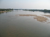
The important water resources of the district is the Ping River
. There are two national parks in the district: Lan Sang National Park
and Taksin Maharat National Park (partly in neighboring Mae Sot).
), which are further subdivided into 102 villages (muban
). The town (thesaban mueang) Tak
covers the tambon Rahaeng, Nong Luang, Chiang Ngoen and Hua Diat, the subdistrict municipality (thesaban tambon) Mai Ngam the complete same-named tambon. There are further 9 Tambon administrative organizations (TAO).
Numbers 10, 16 and 17 belong to the tambon which now form Wang Chao district.
Tak Province
Tak is one of the northern provinces of Thailand. Neighboring provinces are Mae Hong Son, Chiang Mai, Lamphun, Lampang, Sukhothai, Kamphaeng Phet, Nakhon Sawan, Uthai Thani and Kanchanaburi...
, northern Thailand
Thailand
Thailand , officially the Kingdom of Thailand , formerly known as Siam , is a country located at the centre of the Indochina peninsula and Southeast Asia. It is bordered to the north by Burma and Laos, to the east by Laos and Cambodia, to the south by the Gulf of Thailand and Malaysia, and to the...
.
History
In Sukhothai eraSukhothai kingdom
The Sukhothai Kingdom ) was an early kingdom in the area around the city Sukhothai, in north central Thailand. The Kingdom existed from 1238 till 1438...
, Mueang
Mueang
Mueang were historical semi-independent city-states or principalities in present-day Thailand, Laos, parts of northern Vietnam and the Shan State of Myanmar. Smaller Mueang were subordinate to more powerful neighboring Mueang, which in turn were subordinate to the central king, as described in...
Tak was the western frontier city. The old location of the city was in Tambon Ko Taphao, now Ban Tak district
Amphoe Ban Tak
Ban Tak is a district in the northern part of Tak Province, northern Thailand.-History:The area of Ban Tak is the old location of Mueang Tak. It was an ancient frontier city, located on the west bank of the Ping River in Ban Tha Phra That, Tambon Ko Taphao...
. It was moved because its old location was not strategically good. Another old city name was Ra-haeng.
Mueang Tak district was established in 1886. The first district office was together with the Tak province hall. A new office was established beside Phahonyothin highway
Phahonyothin highway
Phahonyothin Road or Thailand Route 1 is a major road in Bangkok, as well as one of the four major highways in Thailand, along with Mittraphap Road , Sukhumvit Road , and Phetkasem Road...
in 1956. However 1965 it burned down, thus the government rented the house of Luang San Buranurak as a temporary district office. The new office was finished and opened in 1967.
Geography
Neighboring districts are (clockwise from south): Wang Chao, Phop PhraAmphoe Phop Phra
Phop Phra is a district in the southwestern part of Tak Province, northern Thailand.-History:The whole area of Phop Phra was originally Tambon Chong Khaep of Mae Sot district. Due to the large size of Mae Sot and problems with communist insurgents, the government created a separate administration...
, Mae Sot, Mae Ramat
Amphoe Mae Ramat
Mae Ramat is a district in the northwestern part of Tak Province, northern Thailand.-History:The area of Mae Ramat was occupied by Karen people for 100 years. Many people from northern provinces of Thailand moved to establish a new village there. Later the village grew bigger and became the...
, Ban Tak
Amphoe Ban Tak
Ban Tak is a district in the northern part of Tak Province, northern Thailand.-History:The area of Ban Tak is the old location of Mueang Tak. It was an ancient frontier city, located on the west bank of the Ping River in Ban Tha Phra That, Tambon Ko Taphao...
of Tak Province, Ban Dan Lan Hoi
Amphoe Ban Dan Lan Hoi
Ban Dan Lan Hoi is a district in the western part of Sukhothai Province, northern Thailand.- History :In the Sukhothai era, the district area was the western camp of Patrol soldiers. The village located nearby the camp was called Ban Lan Khoi...
of Sukhothai Province
Sukhothai Province
Sukhothai is one of the northern provinces of Thailand. Neighboring provinces are Phrae, Uttaradit, Phitsanulok, Kamphaeng Phet, Tak, and Lampang...
, Phran Kratai
Amphoe Phran Kratai
Phran Kratai is the northernmost district of Kamphaeng Phet Province, northern Thailand.-History:The name of the district translates to Rabbit Hunter and refers to a local legend. A hunter surveyed southward to seek a strategic location to build a frontier city for Sukhothai Kingdom...
, Kosamphi Nakhon of Kamphaeng Phet Province
Kamphaeng Phet Province
Kamphaeng Phet is one of the provinces of Thailand, located in the north of the country. Neighboring provinces are Sukhothai, Phitsanulok, Phichit, Nakhon Sawan and Tak.- Etymology :...
The important water resources of the district is the Ping River
Ping River
The Ping River , along with the Nan River, is one of the two main contributaries of Chao Phraya River. It originates at Doi Chiang Dao in Chiang Dao district, Chiang Mai Province. After passing Chiang Mai town, it flows though the provinces Lamphun, Tak, and Kamphaeng Phet...
. There are two national parks in the district: Lan Sang National Park
Lan Sang National Park
Lan Sang National Park is located in Tak Province, in northern Thailand. Established in 1979, it is an IUCN Category II protected area measuring . Situated on the Tak-Mae Sot Highway in Mueang Tak District, it became the country's 15th national park....
and Taksin Maharat National Park (partly in neighboring Mae Sot).
Administration
The district is subdivided into 14 subdistricts (tambonTambon
Tambon is a local government unit in Thailand. Below district and province , they form the third administrative subdivision level. As of the 2009 there are 7255 tambon, not including the 169 khwaeng of Bangkok, which are set at the same administrative level, thus every district contains 8-10 tambon...
), which are further subdivided into 102 villages (muban
Muban
Muban is the lowest administrative subdivision of Thailand. Usually translated as village, they are the subdivision of tambon. As of 2008, there are 74944 administrative villages in Thailand. As of the 1990 census, the average village consisted of 144 households or 746 persons.A muban does not...
). The town (thesaban mueang) Tak
Tak (town)
Tak is a town in northwest of Thailand, capital of the Tak Province and the Tak district. As of 2005 the town has a population of 19,900 and an area of 7.27 km². It covers the tambon Rahaeng, Nong Luang, Chiang Ngoen and Hua Diat, and is located on the Ping River.-External links:*...
covers the tambon Rahaeng, Nong Luang, Chiang Ngoen and Hua Diat, the subdistrict municipality (thesaban tambon) Mai Ngam the complete same-named tambon. There are further 9 Tambon administrative organizations (TAO).
| No. | Name | Thai | Inh. Population A population is all the organisms that both belong to the same group or species and live in the same geographical area. The area that is used to define a sexual population is such that inter-breeding is possible between any pair within the area and more probable than cross-breeding with individuals... |
|---|---|---|---|
| 1. | Rahaeng | ระแหง | 6,958 |
| 2. | Nong Luang | หนองหลวง | 5,896 |
| 3. | Chiang Ngoen | เชียงเงิน | 3,006 |
| 4. | Hua Diat | หัวเดียด | 3,644 |
| 5. | Nong Bua Nuea | หนองบัวเหนือ | 4,652 |
| 6. | Mai Ngam | ไม้งาม | 9,570 |
| 7. | Pong Daeng | โป่งแดง | 8,936 |
| 8. | Nam Ruem | น้ำรึม | 11,688 |
| 9. | Wang Hin | วังหิน | 9,300 |
| 11. | Mae Tho | แม่ท้อ | 8,069 |
| 12. | Pa Mamuang | ป่ามะม่วง | 4,142 |
| 13. | Nong Bua Tai | หนองบัวใต้ | 6,072 |
| 14. | Wang Prachop | วังประจบ | 12,231 |
| 15. | Taluk Klang Thung | ตลุกกลางทุ่ง | 4,329 |
Numbers 10, 16 and 17 belong to the tambon which now form Wang Chao district.
External links
- amphoe.com (Thai)