
Amphoe Dan Sai
Encyclopedia
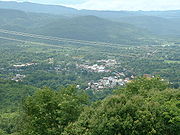
Dan Sai is a district (amphoe
) in the western part of Loei Province
, northeastern Thailand
.
of Loei Province, Lom Kao
and Khao Kho
of Phetchabun Province
, Nakhon Thai
of Phitsanulok Province
, and Na Haeo
of Loei again. To the north is the Xaignabouli Province of Laos
.
The source of the Pa Sak River
is located in the mountains in the eastern part of the district. A big part of the district is part of the Phu Hin Rong Kla National Park
. To the southeast is the Phu Luang Wildlife Sanctuary
.
 The district is subdivided into 10 subdistricts (tambon
), which are further subdivided into 98 villages (muban
). Dan Sai is also the only townshop (thesaban tambon) of the district, covering parts of the tambon Dan Sai. There are further 10 Tambon administrative organizations (TAO).
Amphoe
An amphoe is the second level administrative subdivision of Thailand. Usually translated as district, amphoe make up the provinces, and are analogous to a county seat...
) in the western part of Loei Province
Loei Province
Loei is one of the most sparsely populated provinces of Thailand, located in the North-East. Neighboring provinces are Nong Khai, Udon Thani, Nongbua Lamphu, Khon Kaen, Phetchabun, Phitsanulok...
, northeastern Thailand
Thailand
Thailand , officially the Kingdom of Thailand , formerly known as Siam , is a country located at the centre of the Indochina peninsula and Southeast Asia. It is bordered to the north by Burma and Laos, to the east by Laos and Cambodia, to the south by the Gulf of Thailand and Malaysia, and to the...
.
Geography
Neighboring districts are (from the east clockwise) Phu RueaAmphoe Phu Ruea
Phu Ruea is a district in the western part of Loei Province, northeastern Thailand.-History:The government split off some part of Tha Li, Mueang Loei and Dan Sai districts and made them to the minor district Phu Ruea on October 15 1968 and made it a subordinate of Dan Sai...
of Loei Province, Lom Kao
Amphoe Lom Kao
Lom Kao is the northernmost district of Phetchabun Province, northern Thailand.-History:The first record of Mueang Lom found in the first King Ram Khamhaeng the Great the Great stone pillar. In Rattanakosin era, this area was a big community of Lao people from Vientiane...
and Khao Kho
Amphoe Khao Kho
-Etymology:The name of the district comes from the a kind of palm tree named Kho , that is found a lot in the area, and from the name Khao, mountain. Thus the full name of the district means "Palm tree hills".-History:...
of Phetchabun Province
Phetchabun Province
Phetchabun is one of the northern provinces of Thailand. Neighboring provinces are Loei, Khon Kaen, Chaiyaphum, Lopburi, Nakhon Sawan, Phichit and Phitsanulok.- Geography :...
, Nakhon Thai
Amphoe Nakhon Thai
Nakhon Thai is a district in the eastern part of Phitsanulok Province, northern Thailand.-Geography:Neighboring districts are Wang Thong, Chat Trakan of Phitsanulok Province, Na Haeo, Dan Sai of Loei Province and Khao Kho of Phetchabun Province.The Phu Hin Rong Kla National Park is located in...
of Phitsanulok Province
Phitsanulok Province
Phitsanulok is a provinces of Thailand, located in the north. Neighboring provinces are Loei, Phetchabun, Phichit, Kamphaeng Phet, Sukhothai, Uttaradit. In the north-east it also has a short border with Xaignabouli of Laos....
, and Na Haeo
Amphoe Na Haeo
Na Haeo is the westernmost district of Loei Province, northeastern Thailand.-History:Na Haeo area was the rural part of Dan Sai district. For the people in Na Haeo it was inconvenient to contact to the public services due to the large distance...
of Loei again. To the north is the Xaignabouli Province of Laos
Laos
Laos Lao: ສາທາລະນະລັດ ປະຊາທິປະໄຕ ປະຊາຊົນລາວ Sathalanalat Paxathipatai Paxaxon Lao, officially the Lao People's Democratic Republic, is a landlocked country in Southeast Asia, bordered by Burma and China to the northwest, Vietnam to the east, Cambodia to the south and Thailand to the west...
.
The source of the Pa Sak River
Pa Sak River
The Pa Sak River is a river in central Thailand. The river originates in Dan Sai District, Loei Province, passes through Phetchabun Province as the backbone of the Province...
is located in the mountains in the eastern part of the district. A big part of the district is part of the Phu Hin Rong Kla National Park
Phu Hin Rong Kla National Park
Phu Hin Rong Kla National Park is a national park located in the Loei, Phitsanulok and Phetchabun Provinces of Thailand.-Topography:The park landscape is generally steep mountains. The northern part of the park in stretches to the border with Laos. The Southern part of the park extends into the...
. To the southeast is the Phu Luang Wildlife Sanctuary
Phu Luang Wildlife Sanctuary
Phu Luang Wildlife Sanctuary is a wildlife sanctuary in northern Thailand, located in the south of Loei Province.It covers an area of 897 km², covering area of the tambon Pla Ba and Tha Sala of Phu Ruea district, Phon Sung, Wang Yao and I Pum of Dan Sai, Nong Ngio and Saikhao of Wang Saphung, and...
.
Administration
Tambon
Tambon is a local government unit in Thailand. Below district and province , they form the third administrative subdivision level. As of the 2009 there are 7255 tambon, not including the 169 khwaeng of Bangkok, which are set at the same administrative level, thus every district contains 8-10 tambon...
), which are further subdivided into 98 villages (muban
Muban
Muban is the lowest administrative subdivision of Thailand. Usually translated as village, they are the subdivision of tambon. As of 2008, there are 74944 administrative villages in Thailand. As of the 1990 census, the average village consisted of 144 households or 746 persons.A muban does not...
). Dan Sai is also the only townshop (thesaban tambon) of the district, covering parts of the tambon Dan Sai. There are further 10 Tambon administrative organizations (TAO).
| No. | Name | Thai name | Villages | Inh. Population A population is all the organisms that both belong to the same group or species and live in the same geographical area. The area that is used to define a sexual population is such that inter-breeding is possible between any pair within the area and more probable than cross-breeding with individuals... |
|
|---|---|---|---|---|---|
| 1. | Dan Sai | ด่านซ้าย | 15 | 8,458 | |
| 2. | Pak Man | ปากหมัน | 7 | 3,124 | |
| 3. | Na Di | นาดี | 9 | 3,936 | |
| 4. | Khok Ngam | โคกงาม | 7 | 4,659 | |
| 5. | Phon Sung | โพนสูง | 9 | 4,860 | |
| 6. | Ipum | อิปุ่ม | 13 | 4,595 | |
| 7. | Kok Sathon | กกสะทอน | 11 | 6,878 | |
| 8. | Pong | โป่ง | 11 | 6,057 | |
| 9. | Wang Yao | วังยาว | 7 | 3,563 | |
| 10. | Na Ho | นาหอ | 9 | 3,140 |
External links
- amphoe.com (Thai)