
.gif)
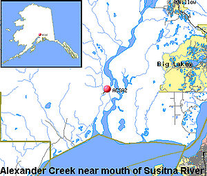
Alexander Creek (Susitna River)
Encyclopedia
Alexander Creek, also known as Taguntna Creek, is a stream from Alexander Lake which merges with the big Susitna River
near the village of Alexander Creek, Alaska
also known as Alexander, Alaska, an Alaska Native and Alaska Bush community, in Matanuska-Susitna Borough
, Alaska
.
at Alexander Creek, Alaska
27 miles (43.5 km) North-West of Anchorage, Alaska
Cook Inlet
Low.
(1900, p. 10), United States Geological Survey
.
. The upper reaches are scenic, with views of the Alaska Range
. Class I water encourages high use by beginning floaters. The lower reaches contain native archaeological sites, historic roadhouses, and the Iditarod Trail
.
with watersheds or shorelines essentially primitive and waters unpolluted. These represent vestiges of primitive America.
with shorelines or watersheds still largely primitive and shorelines largely undeveloped, but accessible in places by roads.
that may have some development along their shorelines, and that may have undergone some impoundment or diversion in the past.
}}
Susitna River
The Susitna River is a long river in the Southcentral Alaska. It is the 15th largest river in the United States of America, ranked by average discharge volume at its mouth. The river stretches from the Susitna Glacier to Cook Inlet....
near the village of Alexander Creek, Alaska
Alexander Creek, Alaska
Alexander Creek, Alaska also known as Alexander, Alaska is an Alaskan Native American Indian Corporation and Alaskan Bush community on Susitna River delta, near mouth of Alexander Creek, northwest of Anchorage, Alaska Cook Inlet Low.- History :...
also known as Alexander, Alaska, an Alaska Native and Alaska Bush community, in Matanuska-Susitna Borough
Matanuska-Susitna Borough, Alaska
-National protected areas:* Chugach National Forest * Denali National Park and Preserve ** Denali Wilderness * Lake Clark National Park and Preserve ** Lake Clark Wilderness -Demographics:...
, Alaska
Alaska
Alaska is the largest state in the United States by area. It is situated in the northwest extremity of the North American continent, with Canada to the east, the Arctic Ocean to the north, and the Pacific Ocean to the west and south, with Russia further west across the Bering Strait...
.
Watershed
Alexander Creek is considered a (Wild; and Scenic, Recreation, Fish, Wildlife, and Cultural) river by the National Park ServiceNational Park Service
The National Park Service is the U.S. federal agency that manages all national parks, many national monuments, and other conservation and historical properties with various title designations...
Course
Alexander Creek is 35 miles (56.3 km) long, heads in Alexander Lake, flows South-East to its confluence with Susitna RiverSusitna River
The Susitna River is a long river in the Southcentral Alaska. It is the 15th largest river in the United States of America, ranked by average discharge volume at its mouth. The river stretches from the Susitna Glacier to Cook Inlet....
at Alexander Creek, Alaska
Alexander Creek, Alaska
Alexander Creek, Alaska also known as Alexander, Alaska is an Alaskan Native American Indian Corporation and Alaskan Bush community on Susitna River delta, near mouth of Alexander Creek, northwest of Anchorage, Alaska Cook Inlet Low.- History :...
27 miles (43.5 km) North-West of Anchorage, Alaska
Anchorage, Alaska
Anchorage is a unified home rule municipality in the southcentral part of the U.S. state of Alaska. It is the northernmost major city in the United States...
Cook Inlet
Cook Inlet
Cook Inlet stretches from the Gulf of Alaska to Anchorage in south-central Alaska. Cook Inlet branches into the Knik Arm and Turnagain Arm at its northern end, almost surrounding Anchorage....
Low.
History
Alexander Creek reported in 1898 by EldridgeEldridge
-Surname:*Charles W. Eldridge , Massachusetts businessman and politician*Clarence Eldridge , American baseball umpire and advertising executive...
(1900, p. 10), United States Geological Survey
United States Geological Survey
The United States Geological Survey is a scientific agency of the United States government. The scientists of the USGS study the landscape of the United States, its natural resources, and the natural hazards that threaten it. The organization has four major science disciplines, concerning biology,...
.
Economy
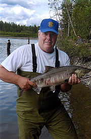
Popular river for anglers, particularly for King Salmon and Coho SalmonCoho salmon
The Coho salmon, Oncorhynchus kisutch, is a species of anadromous fish in the salmon family. Coho salmon are also known as silver salmon or "silvers". It is the state animal of Chiba, Japan.-Description:...
. The upper reaches are scenic, with views of the Alaska Range
Alaska Range
The Alaska Range is a relatively narrow, 650-km-long mountain range in the southcentral region of the U.S. state of Alaska, from Lake Clark at its southwest end to the White River in Canada's Yukon Territory in the southeast...
. Class I water encourages high use by beginning floaters. The lower reaches contain native archaeological sites, historic roadhouses, and the Iditarod Trail
Iditarod Trail
The Iditarod Trail, also known historically as the Seward-to-Nome Mail Trail, refers to a thousand-plus mile historic and contemporary trail system in the U.S...
.
Lists
Tributaties
From mouth going upstream to the source:- Lower Sucker Creek 61°36′18"N 150°39′35"W, elevation: 112 feet (34.1 m)
- Sucker Lake 61°39′20"N 150°54′14"W, elevation: 203 feet (61.9 m)
-
-
- Upper Sucker Creek 61°39′15"N 150°54′26"W, elevation: 203 feet (61.9 m)
-
- Lake 61°34′44"N 151°1′22"W
- Alexander Lake
- Lake 61°34′44"N 151°1′22"W
-
Communities
From mouth going upstream to the source:- Alexander Creek, AlaskaAlexander Creek, AlaskaAlexander Creek, Alaska also known as Alexander, Alaska is an Alaskan Native American Indian Corporation and Alaskan Bush community on Susitna River delta, near mouth of Alexander Creek, northwest of Anchorage, Alaska Cook Inlet Low.- History :...
also known as Alexander, Alaska - Dinglishna Hills, AlaskaDinglishna Hills, AlaskaDinglishna Hills is an unincorporated community in Matanuska-Susitna Borough, Alaska, USA. An Alaskan Bush community, it was created by State of Alaska Department of Natural Resources through land auctions and subsequent over-the-counter land sales, in between the big Susitna River and Alexander...
Outstandingly Remarkable Values (ORVs)
- Scenery (S): The landscape elements of landform, vegetation, water, color, and related factors result in notable or exemplary visual features and/or attractions. When analyzing scenic values, additional factors -- such as seasonal variations in vegetation, scale of cultural modifications, and the length of time negative intrusions are viewed -- may be considered. Scenery and visual attractions may be highly diverse over the majority of the river or river segment.
- Recreation (R): Recreational opportunities are, or have the potential to be, popular enough to attract visitors from throughout or beyond the region of comparison or are unique or rare within the region. Visitors are willing to travel long distances to use the river resources for recreational purposes. River-related opportunities could include, but are not limited to, sightseeing, wildlife observation, camping, photography, hiking, fishing and boating.
- Interpretive opportunities may be exceptional and attract, or have the potential to attract, visitors from outside the region of comparison.
- The river may provide, or have the potential to provide, settings for national or regional usage or competitive events.
- Geology (G): The river, or the area within the river corridor, contains one or more example of a geologic feature, process or phenomenon that is unique or rare within the region of comparison. The feature(s) may be in an unusually active stage of development, represent a "textbook" example, and/or represent a unique or rare combination of geologic features (erosional, volcanic, glacial, or other geologic structures).
- Fish (F): Fish values may be judged on the relative merits of either fish populations, habitat, or a combination of these river-related conditions.
- Populations: The river is nationally or regionally an important producer of resident and/or anadromous fish species. Of particular significance is the presence of wild stocks and/or federal or state listed (or candidate) threatened, endangered or sensitive species. Diversity of species is an important consideration and could, in itself, lead to a determination of "outstandingly remarkable."
- Habitat: The river provides exceptionally high quality habitat for fish species indigenous to the region of comparison. Of particular significance is habitat for wild stocks and/or federal or state listed (or candidate) threatened, endangered or sensitive species. Diversity of habitats is an important consideration and could, in itself, lead to a determination of "outstandingly remarkable."
- Wildlife (W): Wildlife values may be judged on the relative merits of either terrestrial or aquatic wildlife populations or habitat or a combination of these conditions.
- Populations: The river, or area within the river corridor, contains nationally or regionally important populations of indigenous wildlife species. Of particular significance are species considered to be unique, and/or populations of federal or state listed (or candidate) threatened, endangered or sensitive species. Diversity of species is an important consideration and could, in itself, lead to a determination of "outstandingly remarkable."
- Habitat: The river, or area within the river corridor, provides exceptionally high quality habitat for wildlife of national or regional significance, and/or may provide unique habitat or a critical link in habitat conditions for federal or state listed (or candidate) threatened, endangered or sensitive species. Contiguous habitat conditions are such that the biological needs of the species are met. Diversity of habitats is an important consideration and could, in itself, lead to a determination of "outstandingly remarkable."
- Prehistory (P): The river, or area within the river corridor, contains a site(s) where there is evidence of occupation or use by Native Americans. Sites must have unique or rare characteristics or exceptional human interest value(s). Sites may have national or regional importance for interpreting prehistory; may be rare and represent an area where a culture or cultural period was first identified and described; may have been used concurrently by two or more cultural groups; and/or may have been used by cultural groups for rare sacred purposes. Many such sites are listed on the National Register of Historic Places, which is administered by the NPS.
- History (H): The river or area within the river corridor contains a site(s) or feature(s) associated with a significant event, an important person, or a cultural activity of the past that was rare or one-of-a-kind in the region. Many such sites are listed on the National Register of Historic Places. A historic site(s) and/or features(s) is 50 years old or older in most cases.
- Cultural (C): The river or area within the river corridor contains archaeological sites or areas significant to traditional cultures. Examples might be American Indian burial grounds, petroglyphs, the oldest known human use site in a region, or streams that support traditional agriculture, subsistence fishing, or religious ceremonies.
- Other Values (O): While no specific national evaluation guidelines have been developed for the "other similar values" category, assessments of additional river-related values consistent with the foregoing guidance may be developed -- including, but not limited to, hydrology, paleontology and botany resources.
Potential Classification
- Wild rivers (W): Those rivers or sections of rivers that are free of impoundments and generally inaccessible except by trail,
with watersheds or shorelines essentially primitive and waters unpolluted. These represent vestiges of primitive America.
- Scenic rivers (S): Those rivers or sections of rivers that are free of impoundments,
with shorelines or watersheds still largely primitive and shorelines largely undeveloped, but accessible in places by roads.
- Recreational rivers (R): Those rivers or sections of rivers that are readily accessible by road or railroad,
that may have some development along their shorelines, and that may have undergone some impoundment or diversion in the past.
}}