
Albion Falls
Encyclopedia
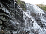
Albion Falls is a 19 m classical/cascade waterfall
flowing down the Niagara Escarpment
in Red Hill Valley
, in Hamilton
, Ontario
, Canada
. With cascade falls the downpour is staggered into a series of steps causing water to "cascade". The top of the falls are located on Mud Street. The lower-end of the falls can be found at the south-end of King's Forest Park in lower Hamilton by following the Red Hill Creek south towards the Niagara Escarpment.
Albion Falls was once seriously considered as a possible source of water for Hamilton. Rocks from the Albion Falls area were used in the construction of the Royal Botanical Gardens' Rock Garden.
The falls were supposedly the site of a suicide, and are allegedly haunted. The ravine at the Albion Falls has a legend of the Lover's Leap
. The story is that early in the 19th century young Jane Riley, disappointed in love with Joseph Rousseau, stood at the top of a steep cliff not far from thundering Albion Falls and flung herself to the bottom 100 ft (30.5 m) below. The steep drop has since been dubbed "Lovers' Leap" and many tales have grown up about the suicide.
Nearby attractions include the Bruce Trail
, Buttermilk Falls
, Devil's Punch Bowl
, Felker's Falls
, Confederation Park (via Red Hill Trail), Mohawk 4 Ice Centre
at Mohawk Sports Park
, scenic views of lower Hamilton, King's Forest Golf Course and Park, Gage Park and Hamilton Children's Museum.
To reach Albion Falls by car, exit on Dartnell Road from the Lincoln M. Alexander Parkway
. Go south on Dartnell, then go left onto Stone Church Road East
. Turn left onto Pritchard Road, then left again onto Mud Street. You will find two parking lots available on either side of Mud Street where it connects with Mountain Brow Boulevard.
You can also reach it by taking Mohawk Road
till it ends at the Escarpment, then take the road around the brow and it will be on the left side. You can also take Limeridge Road East
till it dead ends at the brow, then turn left and then a quick right into the parking lot.
Note: Due to the completion of the Red Hill Valley Parkway
, you can no longer reach Albion Falls via Mud Street.
Waterfall
A waterfall is a place where flowing water rapidly drops in elevation as it flows over a steep region or a cliff.-Formation:Waterfalls are commonly formed when a river is young. At these times the channel is often narrow and deep. When the river courses over resistant bedrock, erosion happens...
flowing down the Niagara Escarpment
Niagara Escarpment
The Niagara Escarpment is a long escarpment, or cuesta, in the United States and Canada that runs westward from New York State, through Ontario, Michigan, Wisconsin and Illinois...
in Red Hill Valley
Red Hill Valley
Red Hill Valley is a valley in eastern and south-eastern Hamilton, Ontario, Canada. The valley is named after and home to the Red Hill Creek, which flows from south-east to north-west, from the Niagara Escarpment to Hamilton harbour, a distance of . The name of the area comes from the reddish soil,...
, in Hamilton
Hamilton, Ontario
Hamilton is a port city in the Canadian province of Ontario. Conceived by George Hamilton when he purchased the Durand farm shortly after the War of 1812, Hamilton has become the centre of a densely populated and industrialized region at the west end of Lake Ontario known as the Golden Horseshoe...
, Ontario
Ontario
Ontario is a province of Canada, located in east-central Canada. It is Canada's most populous province and second largest in total area. It is home to the nation's most populous city, Toronto, and the nation's capital, Ottawa....
, Canada
Canada
Canada is a North American country consisting of ten provinces and three territories. Located in the northern part of the continent, it extends from the Atlantic Ocean in the east to the Pacific Ocean in the west, and northward into the Arctic Ocean...
. With cascade falls the downpour is staggered into a series of steps causing water to "cascade". The top of the falls are located on Mud Street. The lower-end of the falls can be found at the south-end of King's Forest Park in lower Hamilton by following the Red Hill Creek south towards the Niagara Escarpment.
Albion Falls was once seriously considered as a possible source of water for Hamilton. Rocks from the Albion Falls area were used in the construction of the Royal Botanical Gardens' Rock Garden.
The falls were supposedly the site of a suicide, and are allegedly haunted. The ravine at the Albion Falls has a legend of the Lover's Leap
Lover's Leap
Lovers' Leap , is a toponym given to a number of locations of varying height, usually isolated, with the risk of a fatal fall and the possibility of a deliberate jump...
. The story is that early in the 19th century young Jane Riley, disappointed in love with Joseph Rousseau, stood at the top of a steep cliff not far from thundering Albion Falls and flung herself to the bottom 100 ft (30.5 m) below. The steep drop has since been dubbed "Lovers' Leap" and many tales have grown up about the suicide.
Nearby attractions include the Bruce Trail
Bruce Trail
The Bruce Trail is a hiking trail in southern and central Ontario, Canada.-General:The trail follows the edge of the Niagara Escarpment, one of the thirteen UNESCO World Biosphere Reserves in Canada, for almost...
, Buttermilk Falls
Buttermilk Falls
Buttermilk Falls is a 23 metre high plunge waterfall found below Oak Knoll Park Buttermilk Falls is a 23 metre high plunge waterfall found below Oak Knoll Park Buttermilk Falls is a 23 metre high plunge waterfall found below Oak Knoll Park (adjacent to King's Forest Park, Mountain Brow Boulevard...
, Devil's Punch Bowl
Devil's Punch Bowl (Hamilton, Ontario)
Devil's Punch Bowl is a 37 metre ribbon waterfall on the Niagara Escarpment, in the Stoney Creek community of Hamilton, Ontario, Canada. It is found in the Devil's Punchbowl Conservation Area, maintained by the Hamilton Conservation Authority, and features an escarpment access trail with...
, Felker's Falls
Felker's Falls (Hamilton, Ontario)
Felker's Falls is a 22 metre high ribbon style waterfall found at the Felker's Falls Conservation Area, a small park within a subdivision in near Stoney Creek in East Hamilton, Ontario, Canada...
, Confederation Park (via Red Hill Trail), Mohawk 4 Ice Centre
Mohawk 4 Ice Centre
Mohawk 4 Ice Centre is a recreation complex found in Mohawk Sports Park on Mountain Brow Boulevard near Mohawk Road East in Hamilton, Ontario, Canada....
at Mohawk Sports Park
Mohawk Sports Park
Mohawk Sports Park, is a large park on the east mountain of Hamilton, Ontario, 1100 Mohawk Road East, with a number of sporting facilities including Bernie Arbour Memorial Stadium and the Mohawk 4 Ice Centre, . Also known as Commonwealth Park and Upper King's Forest Park....
, scenic views of lower Hamilton, King's Forest Golf Course and Park, Gage Park and Hamilton Children's Museum.
Directions
To reach Albion Falls via a walking trail, take the Escarpment Rail Trail or the Albion Side Trail of the Bruce Trail.To reach Albion Falls by car, exit on Dartnell Road from the Lincoln M. Alexander Parkway
Lincoln M. Alexander Parkway
The Lincoln Alexander Parkway, officially nicknamed "The Linc", is a municipal expressway in the Canadian city of Hamilton, Ontario. Located on the Hamilton mountain, atop the Niagara Escarpment...
. Go south on Dartnell, then go left onto Stone Church Road East
Stone Church Road (Hamilton, Ontario)
Stone Church Road, is a two-way Upper City east-west arterial road in Hamilton, Ontario, Canada. It starts at Golf Links Road, just east of Meadowlands, and goes across the Escarpment and ends at Upper Mount Albion Road....
. Turn left onto Pritchard Road, then left again onto Mud Street. You will find two parking lots available on either side of Mud Street where it connects with Mountain Brow Boulevard.
You can also reach it by taking Mohawk Road
Mohawk Road (Hamilton, Ontario)
Mohawk Road, is an Upper City arterial road in Hamilton, Ontario, Canada. It is a two-way street throughout that starts just West of Highway 403 & Meadowlands and travels eastward linking up with the Lincoln M. Alexander Parkway. Mohawk Road east of Highway 403 resumes again in front of Iroquoia...
till it ends at the Escarpment, then take the road around the brow and it will be on the left side. You can also take Limeridge Road East
Limeridge Road (Hamilton, Ontario)
Limeridge Road is a two-way Upper City collector road in Hamilton, Ontario, Canada. It starts off just West of Garth Street/William McCulloch Park as Limeridge Court and cuts across the Hamilton mountain eastward running parallel with the Lincoln M...
till it dead ends at the brow, then turn left and then a quick right into the parking lot.
Note: Due to the completion of the Red Hill Valley Parkway
Red Hill Valley Parkway
The Red Hill Valley Parkway , referred to as the Red Hill Creek Expressway during planning is a municipal expressway in the Canadian city of Hamilton, Ontario. The route connects the Lincoln M. Alexander Parkway, Hamilton's second municipal expressway, to the Queen Elizabeth Way near Hamilton...
, you can no longer reach Albion Falls via Mud Street.
Images
External links
- Albion Falls: Photos and Updated Information
- Albion Falls (www.start.ca)
- Albion Falls (www.hauntedhamilton.com)
- Cascades and Waterfalls of Hamilton (www.waterfalls.hamilton.ca)
- Bruce Trail (www.brucetrail.org)
- Hamilton- "The Waterfall Capital of the World" (www.cityofwaterfalls.ca)
- Vintage Postcards: Waterfalls in and around Hamilton, Ontario
Maps
- Hamilton Waterfall Map PDF. (http://map.hamilton.ca)
- Map: Hamilton Waterfalls (www.hamiltonnature.org)