

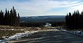
Alberta Highway 734
Encyclopedia
Alberta
Alberta is a province of Canada. It had an estimated population of 3.7 million in 2010 making it the most populous of Canada's three prairie provinces...
, Canada
Canada
Canada is a North American country consisting of ten provinces and three territories. Located in the northern part of the continent, it extends from the Atlantic Ocean in the east to the Pacific Ocean in the west, and northward into the Arctic Ocean...
that travels through the forested foothills of the Rocky Mountains
Rocky Mountains
The Rocky Mountains are a major mountain range in western North America. The Rocky Mountains stretch more than from the northernmost part of British Columbia, in western Canada, to New Mexico, in the southwestern United States...
. It is formerly part of Forestry Trunk Road and is still colloquially referred to as such.
Preceded by the remaining central segment of Forestry Trunk Road, Highway 734 begins south of the Red Deer River
Red Deer River
The Red Deer River is a river in Alberta, Canada. It is a major tributary of the South Saskatchewan River.Red Deer River has a total length of and a drainage area of...
to the southwest of Sundre
Sundre, Alberta
Sundre is a town in central Alberta, Canada. It is located in Mountain View County, northwest from Calgary, along the Cowboy Trail in the Canadian Rockies foothills....
. Succeeded by Highway 40, which was also formerly part of Forestry Trunk Road, the highway ends north of the Pembina River
Pembina River (Alberta)
Pembina is a river in central Alberta, Canada. It is a tributary of the Athabasca River.Pembina is a Canadian French name for the high bush cranberry . The river gives the name to the Pembina oil field,an oil and gas producing region centered around Drayton Valley...
.
Historically, Forestry Trunk Road is a north-south resource road that ran from the Crowsnest Highway
Crowsnest Highway
The Crowsnest Highway, also known as the Interprovincial or, in British Columbia, the Southern Trans-Provincial, is an east-west highway, in length, through the southern parts of British Columbia and Alberta, providing the shortest highway connection between British Columbia's Lower Mainland and...
(Highway 3) in southern Alberta
Southern Alberta
Southern Alberta is a region located in the Canadian province of Alberta. As of the year 2004, the region's population was approximately 272,017. The primary cities are Lethbridge and Medicine Hat...
to Highway 43 in northern Alberta
Northern Alberta
Northern Alberta is a region located in the Canadian province of Alberta.Its primary industry is oil and gas, with large heavy oil reserves being exploited at the Athabasca Oil Sands and Wabasca Area in the east of the region...
. Over time, some segments of the road have been designated as parts of Highway 40 or Highway 734, while the northernmost segment between Highway 40 and Highway 43 is no longer named Forestry Trunk Road.
Currently, two segments of Forestry Trunk Road officially remain – a southern segment from the Municipality of Crowsnest Pass
Crowsnest Pass, Alberta
The Municipality of Crowsnest Pass is a specialized municipality located in the Crowsnest Pass of the Rocky Mountains in southwest Alberta, Canada. The municipality formed as a result of the amalgamation of five municipalities – the Village of Bellevue, the Town of Blairmore, Town of Coleman, the...
to Highway 541 to the southwest of Longview
Longview, Alberta
Longview is a village in southern Alberta, Canada. It is located in the Canadian Rockies foothills, on Cowboy Trail, 32 km west of High River and 64 km south of Calgary...
, and a short central segment from Highway 579 west of Cremona
Cremona, Alberta
Cremona is a village in central Alberta, Canada. It is located north of Cochrane and west of Carstairs, along the Cowboy Trail .- Demographics :In 2006, Cremona had a population of 463 living in 198 dwellings, a 11.6% increase from 2001...
to south of the Red Deer River. The southern segment is preceded and succeeded by the first and second segments of Highway 40 respectively, while the central segment is preceded by the third segment of Highway 40 and succeeded by Highway 734.
Route description
The southern remaining segment of Forestry Trunk Road begins 3.8 km (2.4 mi) north of the Crowsnest Highway (Highway 3) as a continuation of the southernmost segment of Highway 40. Over its 99 km (61.5 mi) length, the gravel road provides access to numerous public campgrounds, crosses the Oldman River, and intersects with Highway 532. It also passes near the Bob Creek Wildland Provincial Park, Livingstone Falls, and the Don Getty Wildland Provincial Park before ending at its intersection with Highway 541 and the second segment of Highway 40, which was part of Forestry Trunk Road before being designated a provincial highway.Another former segment of Forestry Trunk Road, now the third segment of Highway 40, begins at Highway 1A to the west of Cochrane
Cochrane, Alberta
Cochrane is a town in the Canadian province of Alberta. The town is located 18 km west of the Calgary city limits along Highway 1A. With a population of 15,424 , Cochrane is the second largest town in Alberta and one of the fastest growing communities in Canada...
and ends 46 km (28.6 mi) later at an intersection with Highway 579. Highway 40 continues as the central remaining segment of Forestry Trunk Road for 27 km (16.8 mi) to a point 8 km (5 mi) prior to the Red Deer River. The road then continues for 268 km (166.5 mi) as Highway 734 to north of the Pembina River, north of the Elk River Indian reserve, where it becomes the fourth segment of Highway 40.
Over its course, the central segment of Forestry Trunk Road combined with Highway 734 provides access to Ram Falls Provincial Park
Ram Falls Provincial Park
Ram Falls Provincial Park is a provincial park in Alberta, Canada, located south of Nordegg and west of Rocky Mountain House on Highway 734....
and numerous campgrounds, and intersects Highway 579, Highway 584, Highway 591, Highway 752, and Highway 11 (David Thompson Highway) west of Nordegg
Nordegg, Alberta
Nordegg is a hamlet in west-central Alberta, Canada within Clearwater County. It is located in the North Saskatchewan River valley in the foothills of the Canadian Rockies, at the crossroads of David Thompson Highway and the Highway 734 spur of the Bighorn Highway.- History :The community was...
. This stretch also crosses the Red Deer, James
James River (Alberta)
The James River is a medium-sized river in central Alberta. It is a tributary of the Red Deer River.Species of fish commonly found: Brown trout,Rainbow trout,Mountain whitefish,Northern Pike and a few others. It forms in the Rocky Mountains and flows eastward before joining the Red Deer River. The...
, Clearwater, Ram
Ram River
The Ram River is a significant river rising in the Alberta Rocky Mountains. It flows westward, taking on the North Ram River, before joining the North Saskatchewan River near the town of Rocky Mountain House, Alberta. The name Ram Rivulet appears on a David Thompson map of 1814...
, North Saskatchewan
North Saskatchewan River
The North Saskatchewan River is a glacier-fed river that flows east from the Canadian Rockies to central Saskatchewan. It is one of two major rivers that join to make up the Saskatchewan River....
, Blackstone
Blackstone River (Alberta)
Blackstone River is a medium-sized river originating in the front ranges of the Canadian Rockies. It is a tributary of the Brazeau River, which in turn flows into the North Saskatchewan River....
, Brazeau
Brazeau River
The Brazeau River is a river in western Alberta, Canada. It is a major tributary of the North Saskatchewan River.The river was named for Joseph Brazeau, a linguist associated with the Palliser Expedition.-Course:...
, and Pembina rivers.
Forestry Trunk Road
The following is a list of major intersections along the southern segment of Forestry Trunk Road from south to north.{| class="wikitable"
! Municipality !! km !! Description !! Notes
|-
| Municipality of Crowsnest Pass
Crowsnest Pass, Alberta
The Municipality of Crowsnest Pass is a specialized municipality located in the Crowsnest Pass of the Rocky Mountains in southwest Alberta, Canada. The municipality formed as a result of the amalgamation of five municipalities – the Village of Bellevue, the Town of Blairmore, Town of Coleman, the...
/
M.D. of Ranchland No. 66
Ranchland No. 66, Alberta
The Municipal District of Ranchland No. 66 is a municipal district in south western Alberta, Canada.It is located in Census Division 15. The municipality was incorporated on 1995 from the Improvement District No. 6. The municipal seat is in the Town of Nanton, located within the boundaries of...
|| 0 || Preceded by ||
|-
| M.D. of Ranchland No. 66
Ranchland No. 66, Alberta
The Municipal District of Ranchland No. 66 is a municipal district in south western Alberta, Canada.It is located in Census Division 15. The municipality was incorporated on 1995 from the Improvement District No. 6. The municipal seat is in the Town of Nanton, located within the boundaries of...
/
Kananaskis Improvement District
Kananaskis Improvement District
Kananaskis Improvement District is an improvement district in Alberta, Canada. It is located within Alberta's Rockies, sharing much of its boundaries with Kananaskis Country.The administrative centre of the improvement district is Kananaskis Village....
|| 65 || branches off to the east ||
|-
| Kananaskis Improvement District
Kananaskis Improvement District
Kananaskis Improvement District is an improvement district in Alberta, Canada. It is located within Alberta's Rockies, sharing much of its boundaries with Kananaskis Country.The administrative centre of the improvement district is Kananaskis Village....
|| 99 || Ends at / ||
The following is a list of major intersections along the central segment of Forestry Trunk Road from south to north.
{| class="wikitable"
! Municipality !! km !! Description !! Notes
|-
| M.D. of Bighorn No. 8
Bighorn No. 8, Alberta
The Municipal District of Bighorn No. 8 is a municipal district situated in Census Division No. 15 of Alberta, Canada. It is located between Calgary and Banff National Park, north of Kananaskis Improvement District. Highway 1 bisects this county.It was created as a municipal district on January 1,...
|| 0 || Preceded by
branches off to the east ||
|-
| M.D. of Bighorn No. 8
Bighorn No. 8, Alberta
The Municipal District of Bighorn No. 8 is a municipal district situated in Census Division No. 15 of Alberta, Canada. It is located between Calgary and Banff National Park, north of Kananaskis Improvement District. Highway 1 bisects this county.It was created as a municipal district on January 1,...
/
Clearwater County
Clearwater County, Alberta
Clearwater County is a municipal district in west central Alberta, Canada in Division No. 9. Its northwest boundary is the Brazeau River. The municipal seat is located in the town of Rocky Mountain House, which is enclaved within, and technically outside the bounds of the county...
|| 27 || Succeeded by ||
Highway 734
The following is a list of major intersections along Highway 734 from south to north.{| class="wikitable"
! Municipality !! km !! Description !! Notes
|-
| M.D. of Bighorn No. 8
Bighorn No. 8, Alberta
The Municipal District of Bighorn No. 8 is a municipal district situated in Census Division No. 15 of Alberta, Canada. It is located between Calgary and Banff National Park, north of Kananaskis Improvement District. Highway 1 bisects this county.It was created as a municipal district on January 1,...
/
Clearwater County
Clearwater County, Alberta
Clearwater County is a municipal district in west central Alberta, Canada in Division No. 9. Its northwest boundary is the Brazeau River. The municipal seat is located in the town of Rocky Mountain House, which is enclaved within, and technically outside the bounds of the county...
|| 0 || Preceded by Forestry Trunk Road (central segment) ||
|-
|rowspan=4| Clearwater County
Clearwater County, Alberta
Clearwater County is a municipal district in west central Alberta, Canada in Division No. 9. Its northwest boundary is the Brazeau River. The municipal seat is located in the town of Rocky Mountain House, which is enclaved within, and technically outside the bounds of the county...
|| 52 || branches off to the east ||
|-
| 71 || branches off to the east ||
|-
| 100 || branches off to the north ||
|-
| 191 || ||
|-
| Yellowhead County
Yellowhead County, Alberta
Yellowhead County is a municipal district in west central Alberta, Canada.It is the only county in Alberta Division 14, and shares the boundaries with this census division.-History:*1994: Established as a Municipal District of Yellowhead No...
|| 268 || Succeeded by ||