

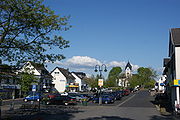
Aegidienberg
Encyclopedia
Aegidienberg is a district of Bad Honnef
in the Rhein-Sieg-Kreis , in North Rhine-Westphalia
. It is located with its 13 villages east of the Siebengebirge
in the foothills of the Niederwesterwald
and is traversed by the A 3 . Until 1969, Aegidienberg was an independent municipality in the former Siegkreis. The name refers to Saint Aegidius (English: Saint Giles
), the patron saint of the local Catholic parish church. The population is over 6,500 people.
In the municipality are two small lakes, the Himberger Lake in the West and the Dachsberger Lake in the East. Both have evolved from the respective basalt quarries were operated there until after the second world war. The Logebach and the Quirrenbach are two source streams of Pleisbachs, which originate in the area and run through them, the Kochenbach is a tributary of the Quirrenbachs. The hills on Aegidienberg area include the Himberg (335,2 m), the Hupperichsberg (307,6 m), the Markhövel (called also Romert ;) (304,3 m) and Dachsberg (360.7 m) - the latter the highest ground point of the district. The main village Aegidienberg on the eponymous mountain is 287 m. On the area you will find two contiguous forest areas, the Aegidienberger forest East and the Vogelsbitze West of the highway. In the far east of Aegidienberg is part of the gliding area Eudenbach with his nature reserve.
Municipality of Aegidienberg summarizes 13 villages: Aegidienberg (Kirchdorf), Brüngsberg, Efferoth, Himberg, Höhe, Hövel, Neichen, Orscheid, Retscheid, Rottbitze, Siefenhoven, Wintersberg and Wülscheid. Parts of Rottlandhof belonging to the area of Rheinbreitbach
lie in Aegidienberg and thus Bad Honnefer area. The district borders with Rheinbreitbach and Windhagen
Rhineland-Palatinate
.
There is no information about the settlement for this time, it is believed that found were here isolated farms and Köhlereien . Since the middle of 13th century, Honnefer lumberjacks afterwards the forests in the area.
Until their extinction, such as in the year 970, the counts of "Auelgau" exerted temporal power over the territory. It was the count Palatine of the Rhine. With the construction of the Löwenburg, in the second half of the 12th century the area fell in their territory and the growing villages were between 1484 and 1815 part of the Office of Löwenburg, which belonged to the Duchy of Berg
.
In the year 1348, a mention with the name "Honferode" found. The name of Aegidienberg replaced probably finally from this name since the 16th century. As one of the fourteen Holy helpers , the Saint Aegidius was venerated probably already since the times of black death in the 14th century.
In a document "von wegen der bergischen Pastoreyen" from the year 1506, the mention of a priest is name "Hermannus" whose Church was located on the site of today's Servatiuskapelle . The "Erkundigungsbuch des Fürstentums Berg" is from "Gilienberg" since the year 1555 as a separate parish .
As owner or tenant , the inhabitants worked the clay, barren soil Aegidienbergs. In contrast to the term topsoil , the term "father soil" is used suburb like. Before the invention of artificial fields almost entirely to the cultivation of barley and oats, which were the staple of the population in the middle ages go for it. The livestock was added. At the beginning of the modern times the diet has been enriched by potatoes and brought the community to their specialty - the "Rievkooche" (done), that are missing to this day at any public event.
Furthermore, operation the population of forest management and had firm commitments such as among the "cream budget" for the vineyards on the slopes of the Rhinein the tithe system of the Office. Also, the Aegidienberger had to cut the wood for the gallows of the Löwenburgschen jurisdiction and this service. The gallows was the present Lohfelder Street in Honnef, probably in the area. Holzschlag right in the forest had only the authorities. The sticks for the livestock to available was the farmers and the sausage of pigs was allowed for them.
Since the middle ages , base metal ores were mined in the area of the Siebengebirge, mainly for the production of copper, zinc and lead. In addition to the work in the mines themselves, the constant need of mines on charcoal caused for the operation of numerous Köhlereien in the area. In the village of Neichen the copper mine "Gotteshilfe" was, in Brüngsberg the pits "Flora", "Zacharias" and "Emma-Sofie", where zinc and copper ore was broken until the spring of 1906. The heaps of mines are still on the side of the Logebachtal. With the fall in base metal prices occurred in 1875 gradually the closure of the mines in the Siebengebirge mountains region.
Basalt is broken in the surrounding area to this day. The basalt quarries at the Dachsberg and the Himberg were connected to the railway network of the Bröltalbahn , which far branches to Asbach
, Bonn-Beuel, Siegburg
and Waldbröl
was enough. The flight stage operation was financed by the quarry operators for the Basalttransport. Access to passenger transport was discussed at various times in the Municipal Council but never realised. The Aegidienberger pits are still around since the 1960s and now serve as lakes and near-recovery objectives, how many other quarries in the area also.
, and Aegidenberg with Honnef, Königswinter
and Ittenbach from 1816 to the new "Bürgermeisterei Königswinter". On 1 July 1846, Aegidienberg received a Municipal Council, which replaced the local councillor existing from Schöffen.After 1862 Honnef and 1889 Königswinter as independent municipalities subject own administrations, the municipality of Aegidienberg remained Königswinter-Land, which was renamed in 1927 "Amt Königswinter-Land" and existed until 1969 together with the municipality of Ittenbach in the "Bürgermeisterei".
Municipality of Aegidienberg
The municipality of Aegidienberg, after former spelling until 1888 also Egidienberg or Aegidienberg, then merely Aegidienberg or (officially recommended) called Aegidienberg, 13 residential places with 366 houses (including uninhabited), 327 households belonged in 1885. The villages belonging to Aegidienberg were Brüngsberg (135 inhabitants), Efferoth (13), Himberg (162), Höhe (47), Hövel (285), Neichen (60), Orscheid (203), Retscheid (44), Rottbitze (97), Siefenhoven (108), Wintersberg (22) and Wüllscheid (255). The municipality of Aegidienberg had 1885 a total 1528 inhabitants, of which 751 males and 777 females. The municipality was on its own Catholic with 1523 believers, there were five Evangelical Christians who were maintained by the parish of Honnef. In 1862 roads of the present-day state road 247 emerged after Wülscheid and Orscheid.
In 1885, the municipality had 1896 hectares, of which 690 ha farmland, 171 ha of meadows and 925 hectares of woodland. With Honnef joined the community was been already in 1855 on a country road (now State Road 144), which initiated and of Himberg about Asbach Flammersfeld, and later up to Altenkirchen, led by Raiffeisen.
After the idea of Friedrich Wilhelm Raiffeisen about 50 citizens founded the "Aegidienberger Spar- und Darlehenskassenverein" on the 10 January 1898. The cooperative has enabled the expansion of the water distribution network starting in 1902 and supported the automobile society, the aim of which was to build a bus connection to Bad Honnef and Königswinter in 1908.
Probably playing children started a major fire in the village of Orscheid, who destroyed 13 buildings on the Whit Sunday, 12 June 1905. The first Gymnastics Club "Germania" was founded in 1912.
At the beginning of World War I, 1914 all teachers to military service were drafted under the other. Many events were held to promote war bonds. The "Darlehenskassenverein" lost reserves totalling 13,000 reichsmarks to the war bonds. The longer the war lasted all the more urgent were needed raw materials, especially the children had to collect. Paper, Glass and foil, and large quantities of leaf hay for the horses for war. The foliage has been plucked from trees and fresh or gedörrt delivered to the Assembly point to Siegburg. The Dörre took place in all possible places in the households. Copper fittings and all imaginable metal objects from the households were requisitioned in numerous metal collections, even the church bells have been processed in the arms industry.
In November 1923, violent armed conflicts took place in Himberg and Hövel with casualties who were with the events of the Rhenish Republic
related. A monument in Hövel and tombs in the cemetery are reminiscent of the uprising in the Siebengebirge mountains region.
Local craft was established the monastery of St. Josef in which the "Franciscan Sisters of Saint Joseph" in 1926 various charitable institutions maintained since its inauguration starting in 1925, including a children's home or the "Train of virgins" in domestic skills.
During the Nazi dictatorship 600 Soviet were used in the basalt quarries of nearby about prisoners of war as forced laborers . Shortly before the indentation of the forces the people in the Hall of Giershausen were rounded up and deported further inland. Also fierce fighting in the area took place at the end of world War II . After the American had crossed the Rhine forces on 7 March 1945 near Remagen , Aegidienberg came in the next few days under heavy American artilleryfire. Here, German forces had entrenched themselves and fired on the vicinity of Remagen also with heavy artillery. Especially on 13 March many soldiers of all involved forces killed died during fighting, so that a short truce, decided to recover the dead, which was unusual.
On 16 March the Centre came under heavy fire and eleven civilians died in the ruins of the monastery. It had been on the building installing a white flag with Red Cross to approximately sixty children, to protect refugees and not allowed the nuns. In addition, still a radio as command was situated in the courtyard of the monastery, had a impact on enemy fire like a magnet . A nationwide bombing of the town by the US Air Force was averted in the afternoon of same day at the last moment through negotiation and about 150 German soldiers went into captivity, others decided to keep fighting.
After the occupation by American forces on 17 March, the place was occupied by German artillery with so-called and so deliberate "Vernichtungsfeuer" then for several days. The 106 armored brigade Feldherrnhalle and scattered parts of other forces had entrenched themselves in Orscheid and Wülscheid and fired at all villages between Brüngsberg and Rottbitze. This led to strong damage up to the complete destruction of all public and many residential and farm buildings of the town.
In Aegidienberg the battles were over 1 April on the Easter Sunday. Orscheid, Wülscheid, Rottbitze, the slaughter continued many days and the districts changed the occupiers here several times. Supposedly there are find in contemporary editions of the Official Journal of the United States Stars and Stripes. The traces of the fighting are still in the area. In the surrounding forests you will find many Schützenlöcher the U.S. Army, countless Lunar hopper of bullets of all sizes, as well as a huge crater in Wülscheid, where on 10 March 1945 a munitions of the Wehrmacht was blown up during the retreat.
The land consolidation project has become urgent in 1937 was continued in 1948 and completed in 1953. About 13,000 agricultural parcels have been combined to about 1,600. The merger was 2.345 acres field, grassland, forest, water, way and became on Aegidienberger and small parts of Oberpleiser district. in 1955 the then district road opened of Aegidienberg after Ittenbach . In the same year, the inauguration of a new Chapel at the foot of Dachsberg took place. The new Evangelical Church in the village was consecrated on 4 February 1961, since then called Church of peace.
The Sports Club "TTV Aegidienberg", which however already was disbanded in 1952 due to financial reasons was formed shortly after the war. Finally, which was then in the spring of 1958 "Fußballverein Sportfreunde Aegidienberg 1958" launched, which now has other sporting departments in addition to several football teams.
The murderer of Dieter Freese, according to the press, the "most wanted criminals of the Federal Republic" found shelter in a disused cottage of Cologne
industrial Oberreuther, which stood in Hövel in the winter of 1962, for a short time. Later he hid in the Königswinter Ofenkaulen.
Law to the community reorganisation of space Bonn
(Bonn law) of 10 June 1969 Aegidienberg, Bad Honnef, was incorporated on 1 August 1969 in the city. Before a merger of Aegidienbergs was contemplated Ittenbach, Heisterbacherrott, Oberpleis and Stieldorf with the mountain communities.
On the A 3 in Hövel, the Gladbecker hostage crisis took place his violent end on 18 August 1988.
The coat of arms shows three green mountains of the Siebengebirge, Löwenburg, Lohrberg, and Großer Ölberg the bottom pane. On the Middle mountain the Red silver is plaid coat of arms of the Office of Löwenburg Aegidienberg belonged to its judicial and administrative framework, as long as the Office was. Above Aegidienbergs is shown, the Romanesque Tower of St. Giles Church silver on a red background. On 4 November 1963 the coat of arms was meeting officially recognized by the Council on its 44., today you can see it at local clubs.
The route of the end of 2002 opened ICE high-speed rail line Cologne Rhine/Main leads along the A 3 with three tunnels and two bridges over the city. Is the Logebachtal with a 173 metre bridge crosses, crosses the central area of Aegidienbergs in the 1,240 m long Aegidienbergtunnel and the Kochenbachtal spanned by a 150 m long bridge. The 990 m long Rottbitzetunnel is located south of the city limits. The section unit the mountain of the municipal area Kluse was subsequently turned into a 200 m long tunnel. The next ICE-station (Siegburg/Bonn) is located in the town of Siegburg
.
The Schmelztalstraße (L 144) is connected with the valley area of Bad Honnefs. Much of the traffic on this road is through traffic to the A 3.
The municipality has its own brand, the Jillienberger. Aegidienberg is a breed of horsethat is bred by the local Stud Feldmann. The Aegidienberger is one of the speed horsessuch as the there bred Iceland horses.
In addition to the five kindergartens distributed in Aegidienberg, a primary school is located in Aegidienberg. The educational infrastructure is but diminished by the absence of a secondary school. Plans to set up a school for the entire mountain range of the Siebengebirge failed yet to extensions of the educational establishments in the Valley area.
Bad Honnef
Bad Honnef is a spa town in Germany near Bonn in the Rhein-Sieg district, North Rhine-Westphalia. It is located on the border of the neighbouring state Rhineland-Palatinate...
in the Rhein-Sieg-Kreis , in North Rhine-Westphalia
North Rhine-Westphalia
North Rhine-Westphalia is the most populous state of Germany, with four of the country's ten largest cities. The state was formed in 1946 as a merger of the northern Rhineland and Westphalia, both formerly part of Prussia. Its capital is Düsseldorf. The state is currently run by a coalition of the...
. It is located with its 13 villages east of the Siebengebirge
Siebengebirge
The Siebengebirge is a German range of hills to the East of the Rhine, southeast of Bonn, consisting of more than 40 mountains and hills. It is located in the municipalities of Bad Honnef and Königswinter. It is of volcanic origin and came into being between 28 and 15 million years ago...
in the foothills of the Niederwesterwald
Westerwald
The Westerwald is a low mountain range on the right bank of the River Rhine in the German federal states of Rhineland-Palatinate, Hesse and North Rhine-Westphalia. It is a part of the Rhine Massif...
and is traversed by the A 3 . Until 1969, Aegidienberg was an independent municipality in the former Siegkreis. The name refers to Saint Aegidius (English: Saint Giles
Saint Giles
Saint Giles was a Greek Christian hermit saint from Athens, whose legend is centered in Provence and Septimania. The tomb in the abbey Giles was said to have founded, in St-Gilles-du-Gard, became a place of pilgrimage and a stop on the road that led from Arles to Santiago de Compostela, the...
), the patron saint of the local Catholic parish church. The population is over 6,500 people.
Geography
The area of the borough of Aegidienberg includes the areas east of Honnefer urban forest, so of the Siebengebirge . They are attributable to the foothills of the Niederwesterwald. There are the centres on various hills that lie partly in the wider Siebengebirge nature reserve spread. The Siebengebirge itself with its up to 400 meters high mountains separates Aegidienberg from about five kilometres away, in the Rhine Valley, Bad Honnef. Aegidienberg is on average approximately 200 meters higher than Bad Honnef. The two places are linked by the six km-long Schmelztal through which a road winds.In the municipality are two small lakes, the Himberger Lake in the West and the Dachsberger Lake in the East. Both have evolved from the respective basalt quarries were operated there until after the second world war. The Logebach and the Quirrenbach are two source streams of Pleisbachs, which originate in the area and run through them, the Kochenbach is a tributary of the Quirrenbachs. The hills on Aegidienberg area include the Himberg (335,2 m), the Hupperichsberg (307,6 m), the Markhövel (called also Romert ;) (304,3 m) and Dachsberg (360.7 m) - the latter the highest ground point of the district. The main village Aegidienberg on the eponymous mountain is 287 m. On the area you will find two contiguous forest areas, the Aegidienberger forest East and the Vogelsbitze West of the highway. In the far east of Aegidienberg is part of the gliding area Eudenbach with his nature reserve.
Municipality of Aegidienberg summarizes 13 villages: Aegidienberg (Kirchdorf), Brüngsberg, Efferoth, Himberg, Höhe, Hövel, Neichen, Orscheid, Retscheid, Rottbitze, Siefenhoven, Wintersberg and Wülscheid. Parts of Rottlandhof belonging to the area of Rheinbreitbach
Rheinbreitbach
Rheinbreitbach is a municipality in the district of Neuwied, in Rhineland-Palatinate, Germany. A locality of Rheinbreitbach is Breite Heide....
lie in Aegidienberg and thus Bad Honnefer area. The district borders with Rheinbreitbach and Windhagen
Windhagen
Windhagen is a municipality in the district of Neuwied, in Rhineland-Palatinate, Germany.Windhagen consists of the following villages:...
Rhineland-Palatinate
Rhineland-Palatinate
Rhineland-Palatinate is one of the 16 states of the Federal Republic of Germany. It has an area of and about four million inhabitants. The capital is Mainz. English speakers also commonly refer to the state by its German name, Rheinland-Pfalz ....
.
Rule and business since the early Middle Ages
A charter of Cologne Archbishop Wichfried from the year 948 a.d. set the boundaries of the Provostry Oberpleis and moved into a district of Aegidienberg the today's Bad Honnefer, apart from Wülscheid. The limits there laid down there are to this day as a city, as well as in the South and East as pie and border.There is no information about the settlement for this time, it is believed that found were here isolated farms and Köhlereien . Since the middle of 13th century, Honnefer lumberjacks afterwards the forests in the area.
Until their extinction, such as in the year 970, the counts of "Auelgau" exerted temporal power over the territory. It was the count Palatine of the Rhine. With the construction of the Löwenburg, in the second half of the 12th century the area fell in their territory and the growing villages were between 1484 and 1815 part of the Office of Löwenburg, which belonged to the Duchy of Berg
Berg (state)
Berg was a state – originally a county, later a duchy – in the Rhineland of Germany. Its capital was Düsseldorf. It existed from the early 12th to the 19th centuries.-Ascent:...
.
In the year 1348, a mention with the name "Honferode" found. The name of Aegidienberg replaced probably finally from this name since the 16th century. As one of the fourteen Holy helpers , the Saint Aegidius was venerated probably already since the times of black death in the 14th century.
In a document "von wegen der bergischen Pastoreyen" from the year 1506, the mention of a priest is name "Hermannus" whose Church was located on the site of today's Servatiuskapelle . The "Erkundigungsbuch des Fürstentums Berg" is from "Gilienberg" since the year 1555 as a separate parish .
As owner or tenant , the inhabitants worked the clay, barren soil Aegidienbergs. In contrast to the term topsoil , the term "father soil" is used suburb like. Before the invention of artificial fields almost entirely to the cultivation of barley and oats, which were the staple of the population in the middle ages go for it. The livestock was added. At the beginning of the modern times the diet has been enriched by potatoes and brought the community to their specialty - the "Rievkooche" (done), that are missing to this day at any public event.
Furthermore, operation the population of forest management and had firm commitments such as among the "cream budget" for the vineyards on the slopes of the Rhinein the tithe system of the Office. Also, the Aegidienberger had to cut the wood for the gallows of the Löwenburgschen jurisdiction and this service. The gallows was the present Lohfelder Street in Honnef, probably in the area. Holzschlag right in the forest had only the authorities. The sticks for the livestock to available was the farmers and the sausage of pigs was allowed for them.
Since the middle ages , base metal ores were mined in the area of the Siebengebirge, mainly for the production of copper, zinc and lead. In addition to the work in the mines themselves, the constant need of mines on charcoal caused for the operation of numerous Köhlereien in the area. In the village of Neichen the copper mine "Gotteshilfe" was, in Brüngsberg the pits "Flora", "Zacharias" and "Emma-Sofie", where zinc and copper ore was broken until the spring of 1906. The heaps of mines are still on the side of the Logebachtal. With the fall in base metal prices occurred in 1875 gradually the closure of the mines in the Siebengebirge mountains region.
Basalt is broken in the surrounding area to this day. The basalt quarries at the Dachsberg and the Himberg were connected to the railway network of the Bröltalbahn , which far branches to Asbach
Asbach
There are communes and places that have the name Asbach:*Asbach, Birkenfeld, in the Birkenfeld district, Rhineland-Palatinate*Asbach , in the Neuwied district, Rhineland-Palatinate*Asbach-Sickenberg, in the Eichsfeld district, Thuringia...
, Bonn-Beuel, Siegburg
Siegburg
--122.148.78.228 05:06, 14 November 2011 Siegburg is a city in the district of Rhein-Sieg-Kreis, in North Rhine-Westphalia, Germany...
and Waldbröl
Waldbröl
Waldbröl is a town is in the southern part of the Oberbergischer Kreis , in North Rhine-Westphalia, Germany.-Geographical location:The city lies on the slopes of the Nutscheid and is part of the Naturpark Bergisches Land...
was enough. The flight stage operation was financed by the quarry operators for the Basalttransport. Access to passenger transport was discussed at various times in the Municipal Council but never realised. The Aegidienberger pits are still around since the 1960s and now serve as lakes and near-recovery objectives, how many other quarries in the area also.
Prussian time / Germany
With the end of the French occupation under Napoleon I. the Duchy of Berg was merged to 1822 the Prussian Rhine ProvinceRhine Province
The Rhine Province , also known as Rhenish Prussia or synonymous to the Rhineland , was the westernmost province of the Kingdom of Prussia and the Free State of Prussia, within the German Reich, from 1822-1946. It was created from the provinces of the Lower Rhine and Jülich-Cleves-Berg...
, and Aegidenberg with Honnef, Königswinter
Königswinter
Königswinter is a town and summer resort in the Rhein-Sieg district, in North Rhine-Westphalia, Germany. It is situated on the right bank of the Rhine, opposite to Bonn, at the foot of the Siebengebirge.- Main sights :...
and Ittenbach from 1816 to the new "Bürgermeisterei Königswinter". On 1 July 1846, Aegidienberg received a Municipal Council, which replaced the local councillor existing from Schöffen.After 1862 Honnef and 1889 Königswinter as independent municipalities subject own administrations, the municipality of Aegidienberg remained Königswinter-Land, which was renamed in 1927 "Amt Königswinter-Land" and existed until 1969 together with the municipality of Ittenbach in the "Bürgermeisterei".
Municipality of Aegidienberg
The municipality of Aegidienberg, after former spelling until 1888 also Egidienberg or Aegidienberg, then merely Aegidienberg or (officially recommended) called Aegidienberg, 13 residential places with 366 houses (including uninhabited), 327 households belonged in 1885. The villages belonging to Aegidienberg were Brüngsberg (135 inhabitants), Efferoth (13), Himberg (162), Höhe (47), Hövel (285), Neichen (60), Orscheid (203), Retscheid (44), Rottbitze (97), Siefenhoven (108), Wintersberg (22) and Wüllscheid (255). The municipality of Aegidienberg had 1885 a total 1528 inhabitants, of which 751 males and 777 females. The municipality was on its own Catholic with 1523 believers, there were five Evangelical Christians who were maintained by the parish of Honnef. In 1862 roads of the present-day state road 247 emerged after Wülscheid and Orscheid.
In 1885, the municipality had 1896 hectares, of which 690 ha farmland, 171 ha of meadows and 925 hectares of woodland. With Honnef joined the community was been already in 1855 on a country road (now State Road 144), which initiated and of Himberg about Asbach Flammersfeld, and later up to Altenkirchen, led by Raiffeisen.
After the idea of Friedrich Wilhelm Raiffeisen about 50 citizens founded the "Aegidienberger Spar- und Darlehenskassenverein" on the 10 January 1898. The cooperative has enabled the expansion of the water distribution network starting in 1902 and supported the automobile society, the aim of which was to build a bus connection to Bad Honnef and Königswinter in 1908.
Probably playing children started a major fire in the village of Orscheid, who destroyed 13 buildings on the Whit Sunday, 12 June 1905. The first Gymnastics Club "Germania" was founded in 1912.
At the beginning of World War I, 1914 all teachers to military service were drafted under the other. Many events were held to promote war bonds. The "Darlehenskassenverein" lost reserves totalling 13,000 reichsmarks to the war bonds. The longer the war lasted all the more urgent were needed raw materials, especially the children had to collect. Paper, Glass and foil, and large quantities of leaf hay for the horses for war. The foliage has been plucked from trees and fresh or gedörrt delivered to the Assembly point to Siegburg. The Dörre took place in all possible places in the households. Copper fittings and all imaginable metal objects from the households were requisitioned in numerous metal collections, even the church bells have been processed in the arms industry.
In November 1923, violent armed conflicts took place in Himberg and Hövel with casualties who were with the events of the Rhenish Republic
Rhenish Republic
The Rhenish Republic was proclaimed at Aachen in October 1923 during the Occupation of the Ruhr by troops from France and Belgium between January 1923 and 1925...
related. A monument in Hövel and tombs in the cemetery are reminiscent of the uprising in the Siebengebirge mountains region.
Local craft was established the monastery of St. Josef in which the "Franciscan Sisters of Saint Joseph" in 1926 various charitable institutions maintained since its inauguration starting in 1925, including a children's home or the "Train of virgins" in domestic skills.
National Socialist dictatorship / World War II
Starting in 1937, the construction of the Reichsautobahn (now Bundesautobahn 3) changed the face of the environment sustainably. The surveying and construction of the first four-lane cement road in nearby Aegidienberger took place for several years. The Aegidienberger area motorway was opened in September 1939. Some farms were not more profitable to guide through the area loss caused by the construction of the motorway. Also, the parcels for many owners were very scattered and were very small. A land consolidation was started, but due to the war interrupted.During the Nazi dictatorship 600 Soviet were used in the basalt quarries of nearby about prisoners of war as forced laborers . Shortly before the indentation of the forces the people in the Hall of Giershausen were rounded up and deported further inland. Also fierce fighting in the area took place at the end of world War II . After the American had crossed the Rhine forces on 7 March 1945 near Remagen , Aegidienberg came in the next few days under heavy American artilleryfire. Here, German forces had entrenched themselves and fired on the vicinity of Remagen also with heavy artillery. Especially on 13 March many soldiers of all involved forces killed died during fighting, so that a short truce, decided to recover the dead, which was unusual.
On 16 March the Centre came under heavy fire and eleven civilians died in the ruins of the monastery. It had been on the building installing a white flag with Red Cross to approximately sixty children, to protect refugees and not allowed the nuns. In addition, still a radio as command was situated in the courtyard of the monastery, had a impact on enemy fire like a magnet . A nationwide bombing of the town by the US Air Force was averted in the afternoon of same day at the last moment through negotiation and about 150 German soldiers went into captivity, others decided to keep fighting.
After the occupation by American forces on 17 March, the place was occupied by German artillery with so-called and so deliberate "Vernichtungsfeuer" then for several days. The 106 armored brigade Feldherrnhalle and scattered parts of other forces had entrenched themselves in Orscheid and Wülscheid and fired at all villages between Brüngsberg and Rottbitze. This led to strong damage up to the complete destruction of all public and many residential and farm buildings of the town.
In Aegidienberg the battles were over 1 April on the Easter Sunday. Orscheid, Wülscheid, Rottbitze, the slaughter continued many days and the districts changed the occupiers here several times. Supposedly there are find in contemporary editions of the Official Journal of the United States Stars and Stripes. The traces of the fighting are still in the area. In the surrounding forests you will find many Schützenlöcher the U.S. Army, countless Lunar hopper of bullets of all sizes, as well as a huge crater in Wülscheid, where on 10 March 1945 a munitions of the Wehrmacht was blown up during the retreat.
Since the end of the war
On the edge of the highway the troop brought the trafficking and prostitution of the allies in the following years to bloom. Many homeless people erred about, and it was never enlightened robbery in the area, which cost several lives. Prior to the beginning of the 1950s, it should take to identify the many war dead in the area and to provide them with a dignified grave. The dead American soldiers were shipped to their homes. The other soldiers found their last resting on the military cemetery at Ittenbach. Around forty deaths were never identified. The war damage to the buildings have been provisionally fixed. Only in 1946, the school with the approval of the Allied authorities reopened. The renovation of the Catholic Church moved out in stages until the 1960s. Abundant around lying munitions posed a serious danger to life for many years and it came with few accidents dead and injuries.The land consolidation project has become urgent in 1937 was continued in 1948 and completed in 1953. About 13,000 agricultural parcels have been combined to about 1,600. The merger was 2.345 acres field, grassland, forest, water, way and became on Aegidienberger and small parts of Oberpleiser district. in 1955 the then district road opened of Aegidienberg after Ittenbach . In the same year, the inauguration of a new Chapel at the foot of Dachsberg took place. The new Evangelical Church in the village was consecrated on 4 February 1961, since then called Church of peace.
The Sports Club "TTV Aegidienberg", which however already was disbanded in 1952 due to financial reasons was formed shortly after the war. Finally, which was then in the spring of 1958 "Fußballverein Sportfreunde Aegidienberg 1958" launched, which now has other sporting departments in addition to several football teams.
The murderer of Dieter Freese, according to the press, the "most wanted criminals of the Federal Republic" found shelter in a disused cottage of Cologne
Cologne
Cologne is Germany's fourth-largest city , and is the largest city both in the Germany Federal State of North Rhine-Westphalia and within the Rhine-Ruhr Metropolitan Area, one of the major European metropolitan areas with more than ten million inhabitants.Cologne is located on both sides of the...
industrial Oberreuther, which stood in Hövel in the winter of 1962, for a short time. Later he hid in the Königswinter Ofenkaulen.
Law to the community reorganisation of space Bonn
Bonn
Bonn is the 19th largest city in Germany. Located in the Cologne/Bonn Region, about 25 kilometres south of Cologne on the river Rhine in the State of North Rhine-Westphalia, it was the capital of West Germany from 1949 to 1990 and the official seat of government of united Germany from 1990 to 1999....
(Bonn law) of 10 June 1969 Aegidienberg, Bad Honnef, was incorporated on 1 August 1969 in the city. Before a merger of Aegidienbergs was contemplated Ittenbach, Heisterbacherrott, Oberpleis and Stieldorf with the mountain communities.
On the A 3 in Hövel, the Gladbecker hostage crisis took place his violent end on 18 August 1988.
Former coat of arms
The design of the municipal coat of arms was suggested at the beginning of the 1960s Selhofer teachers and Heimatkundler Franz Hermann Kemp and finally at the Euskirchener graphic designer Konrad Schäfer according to heraldic rules.The coat of arms shows three green mountains of the Siebengebirge, Löwenburg, Lohrberg, and Großer Ölberg the bottom pane. On the Middle mountain the Red silver is plaid coat of arms of the Office of Löwenburg Aegidienberg belonged to its judicial and administrative framework, as long as the Office was. Above Aegidienbergs is shown, the Romanesque Tower of St. Giles Church silver on a red background. On 4 November 1963 the coat of arms was meeting officially recognized by the Council on its 44., today you can see it at local clubs.
Population growth
Aegidienberg is grown greatly after the second world war, about half of population growth in Bad Honnef after 1969 accounted Aegidienberg. Aegidienberg has lost its autonomous status by the merger, only the entire town's population is determined by the State Office for data processing and statistics NRW; the following are the population at different dates::| Key date | Inhabitants |
|---|---|
| 1828 | 1.010 |
| 1843 | 1.341 |
| 1858 | 1.445 |
| 1871 | 1.476 |
| 1905 | 1.488 |
| 01.09.1933 | 1.379 |
| 14.08.1963 | 2.890 |
| 1970 | 3.680 |
| 01.01.2002 | 6.673 |
| 01.04.2007 | 6.850 |
Economy and infrastructure
The district is crossed by A 3 to a length of 5240 meters. The interchange Bad Honnef/Linz, who founded the very good transport infrastructure in the municipality is located in the East of Aegidienbergs. Particularly in the outlying Rottbitze, this led in 2000 to large commercial and industrial businesses in the Vogelsbitze/Zilskreuz. More industrial estates at Dachsberg and to the Heideweg is located in the planning. Also Rottbitze a second Versorgunszentrum in 2005 including a hardware store, several discount stores and gas stations.The route of the end of 2002 opened ICE high-speed rail line Cologne Rhine/Main leads along the A 3 with three tunnels and two bridges over the city. Is the Logebachtal with a 173 metre bridge crosses, crosses the central area of Aegidienbergs in the 1,240 m long Aegidienbergtunnel and the Kochenbachtal spanned by a 150 m long bridge. The 990 m long Rottbitzetunnel is located south of the city limits. The section unit the mountain of the municipal area Kluse was subsequently turned into a 200 m long tunnel. The next ICE-station (Siegburg/Bonn) is located in the town of Siegburg
Siegburg
--122.148.78.228 05:06, 14 November 2011 Siegburg is a city in the district of Rhein-Sieg-Kreis, in North Rhine-Westphalia, Germany...
.
The Schmelztalstraße (L 144) is connected with the valley area of Bad Honnefs. Much of the traffic on this road is through traffic to the A 3.
The municipality has its own brand, the Jillienberger. Aegidienberg is a breed of horsethat is bred by the local Stud Feldmann. The Aegidienberger is one of the speed horsessuch as the there bred Iceland horses.
Public bodies
Despite the incorporation to Bad Honnef Aegidienberg has retained a certain independence. Due to the relatively large distance to the city centre in the Valley area, a branch of the city housed a Community Office and the District Committee exists on the Aegidiusplatz in the village centre. Also a so-called "Anlaufstelle" (voice Office) of Bonn main is located in the same building.In addition to the five kindergartens distributed in Aegidienberg, a primary school is located in Aegidienberg. The educational infrastructure is but diminished by the absence of a secondary school. Plans to set up a school for the entire mountain range of the Siebengebirge failed yet to extensions of the educational establishments in the Valley area.
Personalities
- Franz Linnig (1832–1912), Provincial Council and textbook author
- Josef Müller (* 1875 in Aegidienberg), scholar and editor of the Rheinisches Wörterbuch
- Carlo Schmid (1896–1979), SPDpolitician, lived many years in Aegidienberg
- Heinz G. Konsalik (1921–1999), lived many years in Aegidienberg
Literature
- Karl Gast: Aegidienberg im Wandel der Zeiten. Edited by the author in collaboration with the municipality of Aegidienberg, Aegidienberg 1964.
- Wolfgang Wegener: Von der glücklichen Elise bis zur Gotteshilfe. In: Archäologie im Rheinland, 1992, page 159ff., Rheinland Verlag, Köln 1993 ISBN 3-7927-1384-5
- Wilhelm W. Hamacher: Von "Hunferode" bis "Aegidienberg", Bad Honnef, 1995, 51 pages.
- Karl Josef Klöhs: Kaiserwetter am Siebengebirge, Königswinter 2003, ISBN 3-00-012113-7
- Otmar Falkner: Die Quirrenbacher Mühle, in: Heimatblätter des Rhein-Sieg-Kreises, 75.Jg./2007, p. 136-149, ISBN 978-3-938535-26-4