
A370 road
Encyclopedia
The A370 is a primary road
in England
running from Bristol
to Weston-super-Mare
and on to East Brent (near Brent Knoll
) in Somerset
. A more direct route from Bristol to East Brent is the A38
.
From here on, it begins to head south-westwards out of the City. It first bypasses Long Ashton
, then passes through Flax Bourton
, Backwell
, Brockley
, Cleeve
, Congresbury
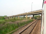
and Hewish, beyone which it crosses the M5 motorway
at junction 21.
The road then enters Weston-super-Mare: a dual carriageway extends most of the way, by passing the built-up area to the east of the town. On reaching the waterfront, the road turns south to run partly along the beach, then leaves Weston at Uphill. It passes Bleadon
and Lympsham before meeting the A38 road
at East Brent.
solely for use by buses, taxis, motorcycle
s, and cars with two or more occupants.
Road
A road is a thoroughfare, route, or way on land between two places, which typically has been paved or otherwise improved to allow travel by some conveyance, including a horse, cart, or motor vehicle. Roads consist of one, or sometimes two, roadways each with one or more lanes and also any...
in England
England
England is a country that is part of the United Kingdom. It shares land borders with Scotland to the north and Wales to the west; the Irish Sea is to the north west, the Celtic Sea to the south west, with the North Sea to the east and the English Channel to the south separating it from continental...
running from Bristol
Bristol
Bristol is a city, unitary authority area and ceremonial county in South West England, with an estimated population of 433,100 for the unitary authority in 2009, and a surrounding Larger Urban Zone with an estimated 1,070,000 residents in 2007...
to Weston-super-Mare
Weston-super-Mare
Weston-super-Mare is a seaside resort, town and civil parish in the unitary authority of North Somerset, which is within the ceremonial county of Somerset, England. It is located on the Bristol Channel coast, south west of Bristol, spanning the coast between the bounding high ground of Worlebury...
and on to East Brent (near Brent Knoll
Brent Knoll
Brent Knoll is a village in Somerset, England, which lies on the southern edge of Brent Knoll – a hill with a height of 137 metres that dominates the low surrounding landscape of the Somerset Levels.-History:...
) in Somerset
Somerset
The ceremonial and non-metropolitan county of Somerset in South West England borders Bristol and Gloucestershire to the north, Wiltshire to the east, Dorset to the south-east, and Devon to the south-west. It is partly bounded to the north and west by the Bristol Channel and the estuary of the...
. A more direct route from Bristol to East Brent is the A38
A38 road
The A38, part of which is also known as the Devon Expressway, is a major A-class trunk road in England.The road runs from Bodmin in Cornwall to Mansfield in Nottinghamshire. It is long, making it one of the longest A-roads in England. It was formerly known as the Leeds — Exeter Trunk Road,...
.
Route
Within Bristol urban area, the road begins at Bath Road roundabout, at the busy junction with A4 near Temple Meads. It then follows the new cut of River Avon west to Cumberland basin, via Bedminster.From here on, it begins to head south-westwards out of the City. It first bypasses Long Ashton
Long Ashton
Long Ashton is a village and civil parish in Somerset, England. It falls within the Unitary Authority of North Somerset, a few miles south west of the city of Bristol. The parish has a population of 4,981...
, then passes through Flax Bourton
Flax Bourton
Flax Bourton is a village and civil parish in Somerset, England. The parish, with a population of 659, is situated within the Unitary Authority of North Somerset, on the edge of Nailsea Moor on the A370 road south west of Bristol city centre....
, Backwell
Backwell
Backwell is a suburban village and civil parish in Somerset, England. It falls within the Unitary Authority of North Somerset and has a population of 5,455.It is south west of Bristol, on the A370 to Weston-super-Mare...
, Brockley
Brockley, Somerset
Brockley is a village and civil parish in Somerset, England. The parish is within the Unitary authority of North Somerset, about south of Nailsea, and includes the village of Chelvey. According to the 2001 census it had a population of 271.-History:...
, Cleeve
Cleeve, Somerset
Cleeve is a village and civil parish in the ceremonial county of Somerset, England. It is situated within the unitary authority of North Somerset, south west of Bristol and has a population of 941 .-History:...
, Congresbury
Congresbury
Congresbury is a village and civil parish in Somerset, England. It is situated in the Unitary authority of North Somerset, and in 2001 had a population of 3,400. It lies on the A370, roughly equidistant between Junction 21 of the M5 and Bristol Airport, approximately south of Bristol city centre,...
and Hewish, beyone which it crosses the M5 motorway
M5 motorway
The M5 is a motorway in England. It runs from a junction with the M6 at West Bromwich near Birmingham to Exeter in Devon. Heading south-west, the M5 runs east of West Bromwich and west of Birmingham through Sandwell Valley...
at junction 21.
The road then enters Weston-super-Mare: a dual carriageway extends most of the way, by passing the built-up area to the east of the town. On reaching the waterfront, the road turns south to run partly along the beach, then leaves Weston at Uphill. It passes Bleadon
Bleadon
Bleadon is a village and civil parish in the historic countyof Somerset, England. It is about south of Weston-super-Mare and, according to the 2001 census, has a population of 1,068.-History:...
and Lympsham before meeting the A38 road
A38 road
The A38, part of which is also known as the Devon Expressway, is a major A-class trunk road in England.The road runs from Bodmin in Cornwall to Mansfield in Nottinghamshire. It is long, making it one of the longest A-roads in England. It was formerly known as the Leeds — Exeter Trunk Road,...
at East Brent.
Condition
The A370 can get extremely busy during rush hour. Congestion points include the approaches to the M5 motorway, the traffic lights in Congresbury and the Long Ashton bypass—which now has a high-occupancy vehicle laneHigh-occupancy vehicle lane
In transportation engineering and transportation planning, a high-occupancy vehicle lane is a lane reserved for vehicles with a driver and one or more passengers...
solely for use by buses, taxis, motorcycle
Motorcycle
A motorcycle is a single-track, two-wheeled motor vehicle. Motorcycles vary considerably depending on the task for which they are designed, such as long distance travel, navigating congested urban traffic, cruising, sport and racing, or off-road conditions.Motorcycles are one of the most...
s, and cars with two or more occupants.