
1967 Southern Minnesota tornado outbreak
Encyclopedia
The 1967 Southern Minnesota tornado outbreak was a tornado outbreak that affected portions of south central and southeast Minnesota
on Sunday, April 30, 1967. The outbreak spawned a total of nine tornadoes resulting in thirteen deaths and eighty injuries. Local area residents refer to the day as "Black Sunday".
was centered in Pierre, South Dakota
. Several fronts stretched from the low pressure area with a stationary front located from north of Sioux Falls, South Dakota
to near LaCrosse, Wisconsin. A warm front
extended from south of Sioux Falls to near Des Moines, Iowa
and St. Louis, Missouri
. Between the two fronts, air temperatures had warmed into the 60s and low 70s and dew points in the 60s. Winds were quite strong in the area, with speeds from 15 to 25 mph from the east-southeast. By early evening, the warm front had moved to near the Minnesota-Iowa
border. By 6:00 pm CDT, tornadoes began to develop along and just north of the warm front as it moved northward through northern Iowa and into southern Minnesota.
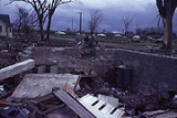
The towns of Albert Lea
and Waseca
were hardest hit.
Minnesota
Minnesota is a U.S. state located in the Midwestern United States. The twelfth largest state of the U.S., it is the twenty-first most populous, with 5.3 million residents. Minnesota was carved out of the eastern half of the Minnesota Territory and admitted to the Union as the thirty-second state...
on Sunday, April 30, 1967. The outbreak spawned a total of nine tornadoes resulting in thirteen deaths and eighty injuries. Local area residents refer to the day as "Black Sunday".
Meteorological synopsis
By mid-afternoon on April 30, a surface low pressure areaLow pressure area
A low-pressure area, or "low", is a region where the atmospheric pressure at sea level is below that of surrounding locations. Low-pressure systems form under areas of wind divergence which occur in upper levels of the troposphere. The formation process of a low-pressure area is known as...
was centered in Pierre, South Dakota
Pierre, South Dakota
Pierre is the capital of the U.S. state of South Dakota and the county seat of Hughes County. The population was 13,646 at the 2010 census, making it the second least populous state capital after Montpelier, Vermont...
. Several fronts stretched from the low pressure area with a stationary front located from north of Sioux Falls, South Dakota
Sioux Falls, South Dakota
Sioux Falls is the largest city in the U.S. state of South Dakota. Sioux Falls is the county seat of Minnehaha County, and also extends into Lincoln County to the south...
to near LaCrosse, Wisconsin. A warm front
Warm front
A warm front is a density discontinuity located at the leading edge of a homogeneous warm air mass, and is typically located on the equator-facing edge of an isotherm gradient...
extended from south of Sioux Falls to near Des Moines, Iowa
Des Moines, Iowa
Des Moines is the capital and the most populous city in the US state of Iowa. It is also the county seat of Polk County. A small portion of the city extends into Warren County. It was incorporated on September 22, 1851, as Fort Des Moines which was shortened to "Des Moines" in 1857...
and St. Louis, Missouri
St. Louis, Missouri
St. Louis is an independent city on the eastern border of Missouri, United States. With a population of 319,294, it was the 58th-largest U.S. city at the 2010 U.S. Census. The Greater St...
. Between the two fronts, air temperatures had warmed into the 60s and low 70s and dew points in the 60s. Winds were quite strong in the area, with speeds from 15 to 25 mph from the east-southeast. By early evening, the warm front had moved to near the Minnesota-Iowa
Iowa
Iowa is a state located in the Midwestern United States, an area often referred to as the "American Heartland". It derives its name from the Ioway people, one of the many American Indian tribes that occupied the state at the time of European exploration. Iowa was a part of the French colony of New...
border. By 6:00 pm CDT, tornadoes began to develop along and just north of the warm front as it moved northward through northern Iowa and into southern Minnesota.
The towns of Albert Lea
Albert Lea, Minnesota
Albert Lea is a city in and the county seat of Freeborn County in the southeastern part of the U.S. state of Minnesota. The population was 18,016 at the 2010 census....
and Waseca
Waseca, Minnesota
As of the census of 2000, there were 8,493 people, 3,388 households, and 2,219 families residing in the city. The population density was 2,215.6 people per square mile . There were 3,563 housing units at an average density of 929.5 per square mile...
were hardest hit.
Confirmed tornadoes
- Table of confirmed tornadoes - after surveys by local weather service offices
Tornado table
| F# Fujita scale The Fujita scale , or Fujita-Pearson scale, is a scale for rating tornado intensity, based primarily on the damage tornadoes inflict on human-built structures and vegetation... |
Location | County | Time (UTC) | Path length | Damage | |
|---|---|---|---|---|---|---|
| South Dakota South Dakota South Dakota is a state located in the Midwestern region of the United States. It is named after the Lakota and Dakota Sioux American Indian tribes. Once a part of Dakota Territory, South Dakota became a state on November 2, 1889. The state has an area of and an estimated population of just over... |
||||||
| F1 | NW of De Smet De Smet, South Dakota -External links:* * * * *... |
Kingsbury Kingsbury County, South Dakota Kingsbury County is a county located in the U.S. state of South Dakota. As of the 2010 census, the population was 5,148. It's county seat is De Smet. It was named for two brothers, George W. and T. A. Kingsbury, who were prominently involved in the affairs of Dakota Territory and members of... |
2115 | 0.1 miles (0.16 km) |
||
| Iowa Iowa Iowa is a state located in the Midwestern United States, an area often referred to as the "American Heartland". It derives its name from the Ioway people, one of the many American Indian tribes that occupied the state at the time of European exploration. Iowa was a part of the French colony of New... |
||||||
| F2 | W of Eagle Grove Eagle Grove, Iowa Eagle Grove is a city in Wright County, Iowa, United States. The population was 3,712 at the 2000 census. Eagle Grove is the largest city in Wright County.-Geography:Eagle Grove is located at near the Boone River.... |
Webster Webster County, Iowa -2010 census:The 2010 census recorded a population of 38,013 in the county, with a population density of . There were 17,035 housing units, of which 15,580 were occupied.-2000 census:... |
2150 | 6.8 miles (10.9 km) |
||
| F2 | E of Estherville Estherville, Iowa Estherville is a city in Emmet County, Iowa, United States. The population was 6,360 in the 2010 census, a decline from 6,656 in the 2000 census. It is the county seat of Emmet County. Estherville is home to the main campus of Iowa Lakes Community College... |
Emmet Emmet County, Iowa -2010 census:The 2010 census recorded a population of 10,302 in the county, with a population density of . There were 4,758 housing units, of which 4,236 were occupied.-2000 census:... |
2200 | 8.2 miles (13.1 km) |
||
| F2 | Emmetsburg Emmetsburg, Iowa Emmetsburg is a city in Palo Alto County, Iowa, United States. The population was 3,958 at the 2000 census. It is the county seat of Palo Alto County. Emmetsburg is home to a campus of Iowa Lakes Community College... to W of Ringsted Ringsted, Iowa Ringsted is a city in Emmet County, Iowa, United States. The population was 436 at the 2000 census.-Geography:Ringsted is located at .According to the United States Census Bureau, the city has a total area of , all of it land.... |
Palo Alto, Emmet Emmet County, Iowa -2010 census:The 2010 census recorded a population of 10,302 in the county, with a population density of . There were 4,758 housing units, of which 4,236 were occupied.-2000 census:... |
2210 | 14 miles (22.4 km) |
||
| F2 | Crystal Lake Crystal Lake, Iowa Crystal Lake is a city in Hancock County, Iowa, United States. The population was 285 at the 2000 census.-Geography:Crystal Lake is located at .... |
Hancock Hancock County, Iowa -2010 census:The 2010 census recorded a population of 11,341 in the county, with a population density of . There were 5,330 housing units, of which 4,741 were occupied.-2000 census:... |
2230 | 4.3 miles (6.9 km) |
||
| F2 | NE of Gruver Gruver, Iowa Gruver is a city in Emmet County, Iowa, United States. The population was 106 at the 2000 census.-Geography:Gruver is located at .According to the United States Census Bureau, the city has a total area of , all of it land.... |
Emmet Emmet County, Iowa -2010 census:The 2010 census recorded a population of 10,302 in the county, with a population density of . There were 4,758 housing units, of which 4,236 were occupied.-2000 census:... |
2233 | 1 miles (1.6 km) |
||
| F3 | Clear Lake Clear Lake, Iowa Clear Lake is a city in Cerro Gordo County, Iowa, United States. The population was 8,161 at the 2000 census. The city is named for the large lake on which it is located. It is the home of a number of marinas, state parks and tourism-related businesses. Clear Lake is also a major stop on Interstate... area |
Cerro Gordo Cerro Gordo County, Iowa -2010 census:The 2010 census recorded a population of 44,151 in the county, with a population density of . There were 22,163 housing units, of which 19,350 were occupied.-2000 census:... |
2305 | 7.7 miles (12.3 km) |
||
| F2 | Fort Madison Fort Madison, Iowa Fort Madison, situated on the Mississippi River, is a city in and one of the county seats of Lee County, Iowa, United States. The other county seat is Keokuk. The population was 10,715 at the 2000 census... area |
Lee Lee County, Iowa -2010 census:The 2010 census recorded a population of 35,862 in the county, with a population density of . There were 16,205 housing units, of which 14,610 were occupied.-2000 census:... |
2320 | 2.3 miles (3.7 km) |
||
| F4 | NE of Manly Manly, Iowa Manly is a city in Worth County, Iowa, United States. The population was 1,342 at the 2000 census. It is part of the Mason City Micropolitan Statistical Area.-Geography:Manly is located at .... to NE of Carpenter Carpenter, Iowa Carpenter is a city in Mitchell County, Iowa, United States. The population was 130 at the 2000 census.-Geography:Carpenter is located at .According to the United States Census Bureau, the town has a total area of , all of it land.... |
Worth Worth County, Iowa -2010 census:The 2010 census recorded a population of 7,598 in the county, with a population density of . There were 3,548 housing units, of which 3,172 were occupied.-2000 census:... |
2328 | 13.3 miles (21.3 km) |
||
| F3 | S of Kensett, IA Kensett, Iowa Kensett is a city in Worth County, Iowa, United States. The population was 280 at the 2000 census. It is part of the Mason City Micropolitan Statistical Area.-Geography:Kensett is located at .... to N of London, MN |
Worth, IA Worth County, Iowa -2010 census:The 2010 census recorded a population of 7,598 in the county, with a population density of . There were 3,548 housing units, of which 3,172 were occupied.-2000 census:... , Freeborn, MN Freeborn County, Minnesota As of the census of 2000, there were 32,584 people, 13,356 households, and 9,015 families residing in the county. The population density was 46 people per square mile . There were 13,996 housing units at an average density of 20 per square mile... |
2330 | 17.2 miles (27.5 km) |
About a half dozen farms were extensively damaged, with at least two farm homes destroyed. | |
| F4 | E of Northwood, IA Northwood, Iowa Northwood is a city in Worth County, Iowa, United States, along the Shell Rock River. The population was 2,050 at the 2000 census. It is the county seat of Worth County.Northwood is part of the Mason City Micropolitan Statistical Area.-Geography:... to E of Myrtle, MN Myrtle, Minnesota Myrtle is a city in Freeborn County, Minnesota, United States. The population was 48 at the 2010 census.-Geography:According to the United States Census Bureau, the city has a total area of , all of it land.-Demographics:... |
Worth, IA Worth County, Iowa -2010 census:The 2010 census recorded a population of 7,598 in the county, with a population density of . There were 3,548 housing units, of which 3,172 were occupied.-2000 census:... Freeborn, MN Freeborn County, Minnesota As of the census of 2000, there were 32,584 people, 13,356 households, and 9,015 families residing in the county. The population density was 46 people per square mile . There were 13,996 housing units at an average density of 20 per square mile... |
0020 | 7.6 miles (12.2 km) |
This tornado destroyed about 10 farms, leveling at least three of them in near-F5 fashion. Ten other farms, mostly in Iowa, were extensively damaged. | |
| F1 | NW of Littleton Littleton, Iowa Littleton is an unincorporated community in Buchanan County, Iowa, United States, northwest of Independence. Littleton lies in section 9 of Perry Township. The town had 250 persons in 1960, the latest year for which a census is available.-History:... |
Buchanan Buchanan County, Iowa -2010 census:The 2010 census recorded a population of 20,958 in the county, with a population density of . There were 8,968 housing units, of which 8,161 were occupied.-2000 census:... |
0100 | 0.1 miles (0.16 km) |
||
| F1 | NW of Montezuma Montezuma, Iowa Montezuma is a city in Poweshiek County, Iowa, United States. The population was 1,440 at the 2000 census. It is the county seat of Poweshiek County.-Geography:Montezuma's longitude and latitude coordinatesin decimal form are 41.584737, -92.525258... |
Poweshiek Poweshiek County, Iowa -2010 census:The 2010 census recorded a population of 18,914 in the county, with a population density of . There were 8,949 housing units, of which 7,555 were occupied.-2000 census:... |
0100 | 0.1 miles (0.16 km) |
||
| F2 | SE of Epworth Epworth, Iowa Epworth is a city in Dubuque County, Iowa, United States. It is part of the Dubuque, Iowa Metropolitan Statistical Area. The population was 1,428 at the 2000 census, but is now estimated to be 1,589 .... |
Dubuque Dubuque County, Iowa Dubuque County is a county located in the U.S. state of Iowa. The population was 93,653 in the 2010 census, an increase from 89,143 in the 2000 census. The county seat is the city of Dubuque. Dubuque County is coterminous with the Dubuque, Iowa Metropolitan Statistical Area, and is the seventh... |
0300 | 2 miles (3.2 km) |
||
| Minnesota Minnesota Minnesota is a U.S. state located in the Midwestern United States. The twelfth largest state of the U.S., it is the twenty-first most populous, with 5.3 million residents. Minnesota was carved out of the eastern half of the Minnesota Territory and admitted to the Union as the thirty-second state... |
||||||
| F2 | E of Waseca Waseca, Minnesota As of the census of 2000, there were 8,493 people, 3,388 households, and 2,219 families residing in the city. The population density was 2,215.6 people per square mile . There were 3,563 housing units at an average density of 929.5 per square mile... |
Waseca Waseca County, Minnesota -External links:**... |
0000 | 9.2 miles (14.7 km) |
Destroyed barns were noted west of Lemond and Meriden. | |
| F3 | NW of Alden Alden, Minnesota Alden is a city in Freeborn County, Minnesota, United States. The population was 661 at the 2010 census.-Geography:According to the United States Census Bureau, the city has a total area of , of which, of it is land and of it is water.... |
Freeborn Freeborn County, Minnesota As of the census of 2000, there were 32,584 people, 13,356 households, and 9,015 families residing in the county. The population density was 46 people per square mile . There were 13,996 housing units at an average density of 20 per square mile... and Waseca Waseca County, Minnesota -External links:**... |
0005 | 14 miles (22.4 km) |
2 deaths - Farm damage was near-F4 in the first part of the path. Homes and barns were destroyed. | |
| F1 | E of Ellendale Ellendale, Minnesota Ellendale is a city in Steele County, Minnesota, United States. The population was 691 at the 2010 census.-Geography:According to the United States Census Bureau, the city has a total area of , all of it land.... |
Steele Steele County, Minnesota As of the census of 2000, there were 33,680 people, 12,846 households, and 9,082 families residing in the county. The population density was 78 people per square mile . There were 13,306 housing units at an average density of 31 per square mile... |
0005 | 0.2 miles (0.32 km) |
||
| F4 | N of Twin Lakes Twin Lakes, Minnesota Twin Lakes is a city in Freeborn County, Minnesota, United States. The population was 151 at the 2010 census.-Geography:According to the United States Census Bureau, the city has a total area of , of which, of it is land and of it is water.... to Owatonna Owatonna, Minnesota Owatonna is a city in Steele County, Minnesota, United States. The population was 25,599 at the 2010 census. It is the county seat of Steele County. Owatonna is home to the Steele County Fairgrounds, which hosts the Steele County Free Fair in August.... |
Freeborn Freeborn County, Minnesota As of the census of 2000, there were 32,584 people, 13,356 households, and 9,015 families residing in the county. The population density was 46 people per square mile . There were 13,996 housing units at an average density of 20 per square mile... and Steele Steele County, Minnesota As of the census of 2000, there were 33,680 people, 12,846 households, and 9,082 families residing in the county. The population density was 78 people per square mile . There were 13,306 housing units at an average density of 31 per square mile... |
0023 | 38.7 miles (61.9 km) |
5 deaths - Farms were leveled at a half dozen locations along the path. There was $2,000,000 damage in Albert Lea, where 26 homes were destroyed and 64 were badly damaged. | |
| F4 | W of Hartland Hartland, Minnesota As of the census of 2000, there were 288 people, 134 households, and 84 families residing in the city. The population density was 1,052.0 people per square mile . There were 144 housing units at an average density of 526.0 per square mile . The racial makeup of the city was 98.61% White, 1.39%... to NE of Waseca Waseca, Minnesota As of the census of 2000, there were 8,493 people, 3,388 households, and 2,219 families residing in the city. The population density was 2,215.6 people per square mile . There were 3,563 housing units at an average density of 929.5 per square mile... |
Freeborn Freeborn County, Minnesota As of the census of 2000, there were 32,584 people, 13,356 households, and 9,015 families residing in the county. The population density was 46 people per square mile . There were 13,996 housing units at an average density of 20 per square mile... and Waseca Waseca County, Minnesota -External links:**... |
0052 | 20.1 miles (32.2 km) |
6 deaths - This tornado followed Hwy-67 into Waseca, destroying or damaging farm buildings on both sides of the road. It cut a four-block-wide swath in town, destroying 16 homes, six of which were leveled, and 25 more were heavily damaged. | |
| F2 | SE of Austin Austin, Minnesota As of the census of 2000, there were 23,314 people, 9,897 households, and 6,076 families residing in the city. The population density was 2,168.2 people per square mile . There were 10,261 housing units at an average density of 954.3 per square mile... |
Mower Mower County, Minnesota As of the census of 2000, there were 38,603 people, 15,582 households, and 10,315 families residing in the county. The population density was 54 people per square mile . There were 16,251 housing units at an average density of 23 per square mile... |
0115 | 3.8 miles (6.1 km) |
At least two barns and one home were unroofed and torn apart. | |
| F2 | E of Marion Marion Township, Minnesota Marion Township is a township in Olmsted County, Minnesota, United States. The population was 6,159 at the 2000 census. On January 1, 2008, it was annexed into Rochester, bringing Rochester's population over 100,000.-Geography:... |
Olmsted Olmsted County, Minnesota As of the census of 2000, there were 124,277 people, 47,807 households, and 32,317 families residing in the county. The population density was 190 people per square mile . There were 49,422 housing units at an average density of 76 per square mile... |
0210 | 6.8 miles (10.9 km) |
A trailer and a barn were destroyed. | |
| Source: Tornado History Project - April 30, 1967 Storm Data | ||||||