
Zumpango, Mexico State
Encyclopedia
Zumpango de Ocampo is a city located in the northeastern part of the state of México
in Mexico
and seat of the municipality
of Zumpango. It lies directly north of the Federal District (Distrito Federal)
within the Greater Mexico City
urban area. The name derives from the Náhuatl
phrase tzompanco which means "row of scalps".
AD. The development of this settlement has been categorized into five phases, the last of which is the area's incorporation into the Aztec Empire between 1150 and 1520. After the Spanish Conquest, the areas around the old lake were divided between Cuautitlán
and Zitlaltepec, but in 1596 the town of Zumpango de la Laguna (of the lake, as it was called then) was made the regional seat of a zone that included Zitlaltepec. It was also made a center of evangelization around this time. During the 17th and 18th centuries, the population congregated toward the growing city, leaving smaller towns in the area depopulated and also giving rise to large hacienda
s such as Hacienda de Santa Lucía, Hacienda de Santa Inés, and Hacienda de Xalpan. Zumpango became the seat of a municipality in 1820.
For its role in the Mexican-American War and the French intervention in Mexico
, Benito Juárez
extended the town's name to "Zumpango de la Laguna, pueblo libre" (a free people) in 1867. In 1877, the state congress changed the name of the city to Zumpango de Ocampo in honor of Melchor Ocampo
, as it gained city status.
During the last decade or so of the 19th century, projects were carried out to drain the Valley of Mexico
. One of the projects consisted of a canal called the "Túnel de Tequixquiac" which reaches Zumpango connecting to the Colorado and Tula Rivers. Because of this, Zumpango experienced considerable economic and social consequences. The Zapatistas
were active here during the Mexican Revolution
in part due to the upheavals the drainage brought.
The census of 2005 reported a population of 53,479 in the city.
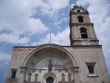
Notable sites in the city include the timple of the Purísima Concepción, constructed in the latter half of the 16th century located in the city center, as well as the Municipal Palace and the Casa Cural. The offices of the Valley of Mexico drainage project here has been converted into a primary school. Also, the Bonfil-Rivera Family house and the house of Don Guadalupe Meléndez are considered significant.
The total population of the municipality as of 2005 was 127,988, with a total territory of 244.08 km² (94.24 sq mi).
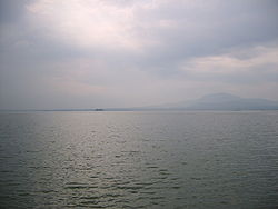 Half of the municipality's territory is flat with only the Cerro (large hill) del Zitlaltepec as its notable elevation at 1650 meters above sea level. Its most notable geographic features are aquatic: the current Zumpango Lake (larger than it was in antiquity) and the man-made Grand Canal which serves to drain the Mexico City basin.
In areas outside of the city, the main economic occupation is still farming, mostly of alfalfa, corn and barley.
Mexico
The United Mexican States , commonly known as Mexico , is a federal constitutional republic in North America. It is bordered on the north by the United States; on the south and west by the Pacific Ocean; on the southeast by Guatemala, Belize, and the Caribbean Sea; and on the east by the Gulf of...
in Mexico
Mexico
The United Mexican States , commonly known as Mexico , is a federal constitutional republic in North America. It is bordered on the north by the United States; on the south and west by the Pacific Ocean; on the southeast by Guatemala, Belize, and the Caribbean Sea; and on the east by the Gulf of...
and seat of the municipality
Municipalities of Mexico
Municipalities are the second-level administrative division in Mexico . There are 2,438 municipalities in Mexico, making the average municipality population 45,616...
of Zumpango. It lies directly north of the Federal District (Distrito Federal)
Mexico City
Mexico City is the Federal District , capital of Mexico and seat of the federal powers of the Mexican Union. It is a federal entity within Mexico which is not part of any one of the 31 Mexican states but belongs to the federation as a whole...
within the Greater Mexico City
Greater Mexico City
Greater Mexico City refers to the conurbation around Mexico City, officially called Mexico City Metropolitan Area , constituted by the Federal District—itself composed of 16 boroughs—and 41 adjacent municipalities of the states of Mexico and Hidalgo...
urban area. The name derives from the Náhuatl
Nahuatl
Nahuatl is thought to mean "a good, clear sound" This language name has several spellings, among them náhuatl , Naoatl, Nauatl, Nahuatl, Nawatl. In a back formation from the name of the language, the ethnic group of Nahuatl speakers are called Nahua...
phrase tzompanco which means "row of scalps".
The city
There is no written evidence of pre-Conquest settlements in the area, but there is archeological evidence which dates an organized town on the shores of the old Lake Zumpango as far back as 200200
Year 200 was a leap year starting on Tuesday of the Julian calendar. At the time, it was known as the Year of the Consulship of Severus and Victorinus...
AD. The development of this settlement has been categorized into five phases, the last of which is the area's incorporation into the Aztec Empire between 1150 and 1520. After the Spanish Conquest, the areas around the old lake were divided between Cuautitlán
Cuautitlán
Cuautitlán is a city and municipality in the State of Mexico, just north of the northern tip of the Federal District within the Greater Mexico City urban area. The city has engulfed most of the municipality, making the two synonymous...
and Zitlaltepec, but in 1596 the town of Zumpango de la Laguna (of the lake, as it was called then) was made the regional seat of a zone that included Zitlaltepec. It was also made a center of evangelization around this time. During the 17th and 18th centuries, the population congregated toward the growing city, leaving smaller towns in the area depopulated and also giving rise to large hacienda
Hacienda
Hacienda is a Spanish word for an estate. Some haciendas were plantations, mines, or even business factories. Many haciendas combined these productive activities...
s such as Hacienda de Santa Lucía, Hacienda de Santa Inés, and Hacienda de Xalpan. Zumpango became the seat of a municipality in 1820.
For its role in the Mexican-American War and the French intervention in Mexico
French intervention in Mexico
The French intervention in Mexico , also known as The Maximilian Affair, War of the French Intervention, and The Franco-Mexican War, was an invasion of Mexico by an expeditionary force sent by the Second French Empire, supported in the beginning by the United Kingdom and the Kingdom of Spain...
, Benito Juárez
Benito Juárez
Benito Juárez born Benito Pablo Juárez García, was a Mexican lawyer and politician of Zapotec origin from Oaxaca who served five terms as president of Mexico: 1858–1861 as interim, 1861–1865, 1865–1867, 1867–1871 and 1871–1872...
extended the town's name to "Zumpango de la Laguna, pueblo libre" (a free people) in 1867. In 1877, the state congress changed the name of the city to Zumpango de Ocampo in honor of Melchor Ocampo
Melchor Ocampo
Melchor Ocampo was a Mexican lawyer, scientist, and liberal politician.His home state was renamed Michoacán de Ocampo in his honour.-Studies:...
, as it gained city status.
During the last decade or so of the 19th century, projects were carried out to drain the Valley of Mexico
Valley of Mexico
The Valley of Mexico is a highlands plateau in central Mexico roughly coterminous with the present-day Distrito Federal and the eastern half of the State of Mexico. Surrounded by mountains and volcanoes, the Valley of Mexico was a centre for several pre-Columbian civilizations, including...
. One of the projects consisted of a canal called the "Túnel de Tequixquiac" which reaches Zumpango connecting to the Colorado and Tula Rivers. Because of this, Zumpango experienced considerable economic and social consequences. The Zapatistas
Liberation Army of the South
The Liberation Army of the South was an armed group formed and led by Emiliano Zapata that took part in the Mexican Revolution. The force was commonly known as the Zapatistas....
were active here during the Mexican Revolution
Mexican Revolution
The Mexican Revolution was a major armed struggle that started in 1910, with an uprising led by Francisco I. Madero against longtime autocrat Porfirio Díaz. The Revolution was characterized by several socialist, liberal, anarchist, populist, and agrarianist movements. Over time the Revolution...
in part due to the upheavals the drainage brought.
The census of 2005 reported a population of 53,479 in the city.
Notable sites in the city include the timple of the Purísima Concepción, constructed in the latter half of the 16th century located in the city center, as well as the Municipal Palace and the Casa Cural. The offices of the Valley of Mexico drainage project here has been converted into a primary school. Also, the Bonfil-Rivera Family house and the house of Don Guadalupe Meléndez are considered significant.
The municipality
As municipal seat, the city of Zumpango de Ocampo is the governing authority for the following communities: Rancho los Mandarines (El Arbolito), San Miguel Bocanegra, Buenavista (Colonia Buenavista), El Capricho, Rancho Coleapan, Santa María Cuevas (Cuevas), U. Fam. Confederación de Trab. Campesinos, Colonia Lázaro Cárdenas del Río, Valle Hermoso, Rancho el Nido, Los Pirineos, Pueblo Nuevo de Morelos, San Bartolo Cuautlalpan, San José de la Loma, San Juan Zitlaltepec, San Juan de Dios (Los Espárragos), Rancho San Luis, Barrio San Miguel (Colonia Abad), San Sebastián, Santa Lucía, Colonia Santa Lucía, Santa María de Guadalupe, Barrio de España, Loma Larga (Barrio de Loma Larga), Colonia los Alcanfores, Rancho la Purísima, El Berrinche, Colonia los Hornos, Granja Riera, Ej. San Bartolo Naucalpan (Rcho. los 3 Hnos.), Rancho San Calixto (Casco Número Tres), Rancho San Francisco de Asís, Los Aguilar, Rancho los Romeros, Ejido el Nido, Ejido San Sebastián, Granja la Esperanza, Rancho la Esperanza, Ejido San Bartolo, Rancho la Josefina, Granja Avigrupo, Hacienda de la Flor, Rancho el Carmen, Los Rodríguez (Familia Santillán), Granjas SYTEX, Los Vázquez, Colonia Pueblo Nuevo (Hacienda San Rosendo), Granja la Zurda, Santa Lucía, Granja Avícola Aviebro, Granja Guadalupe, Barrio Miltenco, El Llano Santa María, Rancho los Aguirre, Rancho Danssek, Barrio de San Miguel (Camino a Valle Hermoso), Colonia San Juan de Guadalupe, Las Espuelas, Fraccionamiento la Trinidad, La Soledad, San Andrés del Llano (Ejido de San Marcos), Colonia San Antonio Abad (El Alcanfor), La Purísima, Colonia Letigio, Colonia Llanos de Guadalupe, Rancho María Lupe, Rancho Teocalli, Colonia el Sol, Barrio el Rincón, Granja Buenos Aires, Paseos de San Juan, Ejido Barriales, El Colorado, El Potrero, Ex-hacienda de Guadalupe, as well as 123 unnamed settlements.The total population of the municipality as of 2005 was 127,988, with a total territory of 244.08 km² (94.24 sq mi).
In areas outside of the city, the main economic occupation is still farming, mostly of alfalfa, corn and barley.