

Ziezi Peak
Encyclopedia
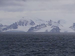
Breznik Heights
Breznik Heights rises to over 600 m in the southeast part of Greenwich Island. They extend 12 km between Santa Cruz Point in the north east and the base of the moraine spit at the mouth of Yankee Harbour in the southwest...
on Greenwich Island
Greenwich Island (South Shetland Islands)
Greenwich Island is an island long and from wide, lying between Robert Island and Livingston Island in the South Shetland Islands. Surface area...
in the South Shetland Islands
South Shetland Islands
The South Shetland Islands are a group of Antarctic islands, lying about north of the Antarctic Peninsula, with a total area of . By the Antarctic Treaty of 1959, the Islands' sovereignty is neither recognized nor disputed by the signatories and they are free for use by any signatory for...
, Antarctica overlooking Targovishte Glacier
Targovishte Glacier
Targovishte Glacier is situated in Breznik Heights on Greenwich Island, and is bounded by Viskyar Ridge to the west, Vratsa Peak to the northeast, and Drangov Peak and Ziezi Peak to the east...
to the west.
The feature is named after the mythical grandson of Noah
Noah
Noah was, according to the Hebrew Bible, the tenth and last of the antediluvian Patriarchs. The biblical story of Noah is contained in chapters 6–9 of the book of Genesis, where he saves his family and representatives of all animals from the flood by constructing an ark...
and progenitor of the Bulgars
Bulgars
The Bulgars were a semi-nomadic who flourished in the Pontic Steppe and the Volga basin in the 7th century.The Bulgars emerge after the collapse of the Hunnic Empire in the 5th century....
, ‘Ziezi ex quo Vulgares’ according to the 354
354
Year 354 was a common year starting on Saturday of the Julian calendar. At the time, it was known as the Year of the Consulship of Constantius and Constantius...
AD Roman
Ancient Rome
Ancient Rome was a thriving civilization that grew on the Italian Peninsula as early as the 8th century BC. Located along the Mediterranean Sea and centered on the city of Rome, it expanded to one of the largest empires in the ancient world....
Chronograph
Chronicle
Generally a chronicle is a historical account of facts and events ranged in chronological order, as in a time line. Typically, equal weight is given for historically important events and local events, the purpose being the recording of events that occurred, seen from the perspective of the...
of Ravenna
Ravenna
Ravenna is the capital city of the Province of Ravenna in the Emilia-Romagna region of Italy and the second largest comune in Italy by land area, although, at , it is little more than half the size of the largest comune, Rome...
.
Location
The peak is located at 62°32′46.2"S 59°37′30.5"W which is 1.35 km east of Viskyar RidgeViskyar Ridge
Viskyar Ridge is a rocky ridge rising to 600 m and extending 2.5 km in north-south direction in Breznik Heights, Greenwich Island in the South Shetland Islands, Antarctica. The ice-free surface area of the ridge is...
, 500 m south of Drangov Peak
Drangov Peak
Drangov Peak is a peak rising to 430 m in the southeast extremity of Breznik Heights on Greenwich Island, Antarctica. Situated 360 m southeast of Vratsa Peak, 1.45 km east by south of the highest point of Viskyar Ridge, 2.8 km west of Fort Point, 500 m north of Ziezi Peak, and...
and 430 m west of Kormesiy Peak
Kormesiy Peak
Kormesiy Peak is a rocky peak rising to 235 m in the southeast extremity of Breznik Heights on Greenwich Island in the South Shetland Islands, Antarctica. Situated situated on the southeast coast of the island, 2.17 km west of Fort Point, 800 m southwest of St. Kiprian Peak, 730 m southeast...
. Bulgarian topographic survey Tangra 2004/05
Tangra 2004/05
The Tangra 2004/05 Expedition was commissioned by the Antarctic Place-names Commission at the Ministry of Foreign Affairs of Bulgaria, managed by the Manfred Wörner Foundation, and supported by the Bulgarian Antarctic Institute, the Institute of Mathematics and Informatics at the Bulgarian Academy...
and mapping in 2009.
Maps
- L.L. Ivanov et al. Antarctica: Livingston Island and Greenwich Island, South Shetland Islands. Scale 1:100000 topographic map. Sofia: Antarctic Place-names Commission of Bulgaria, 2005.
- L.L. Ivanov. Antarctica: Livingston Island and Greenwich, Robert, Snow and Smith Islands. Scale 1:120000 topographic map. Troyan: Manfred Wörner Foundation, 2009. ISBN 978-954-92032-6-4