
Yumali, South Australia
Encyclopedia
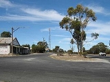
Yumali is a very small country town in South Australia
162km (100 miles) southeast of Adelaide
on the Dukes Highway
(A8). Yumali belongs to the The Coorong District Council
and is in the State electorate of Hammond
and the Federal electorate of Barker
.
Yumali is an aboriginal word meaning "the great land", before that it was known as Wahpunyah Siding. Yumali is situated 100 miles from Adelaide on the Adelaide to Melbourne Express route. Bore
water was used to water the community, surrounding farms and Coomandook
in 1915, but ceased when the River Murray pipeline was accessible in 1971.
There are tennis
courts that still have an active tennis club belonging to the 'Border-Downs Tennis Association'. There is also an old football clubrooms from when Yumali had a team.
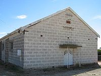 The town hall was opened in 1960.
The newly bitumised Tynan Road (Yumali-Sherlock) and then Kulkawarra Rd (Sherlock-Karoonda
) gives a more comfortable drive for those traveling between Karoonda and the upper South East
and vice-versa.

South Australia
South Australia is a state of Australia in the southern central part of the country. It covers some of the most arid parts of the continent; with a total land area of , it is the fourth largest of Australia's six states and two territories.South Australia shares borders with all of the mainland...
162km (100 miles) southeast of Adelaide
Adelaide
Adelaide is the capital city of South Australia and the fifth-largest city in Australia. Adelaide has an estimated population of more than 1.2 million...
on the Dukes Highway
Dukes Highway
The Dukes Highway is an important 189 kilometre highway corridor in South Australia which links the Australian cities of Adelaide and Melbourne. It is part of the National Highway system spanning Australia, and is signed as National Highway A8....
(A8). Yumali belongs to the The Coorong District Council
The Coorong District Council
The Coorong District Council is a local government area located between the River Murray and the western Limestone Coast in South Australia. The district cover mostly rural areas with small townships, as well as the Coorong National Park....
and is in the State electorate of Hammond
Electoral district of Hammond
Hammond is an electoral district of the House of Assembly in the Australian state of South Australia. It is named after Ruby Hammond, the first indigenous woman to stand for the South Australian parliament...
and the Federal electorate of Barker
Division of Barker
The Division of Barker is an Australian Electoral Division in the south-east of South Australia.The division was created in 1903 and is named for Collet Barker, an early explorer of the region at the mouth of the Murray River...
.
Yumali is an aboriginal word meaning "the great land", before that it was known as Wahpunyah Siding. Yumali is situated 100 miles from Adelaide on the Adelaide to Melbourne Express route. Bore
Water well
A water well is an excavation or structure created in the ground by digging, driving, boring or drilling to access groundwater in underground aquifers. The well water is drawn by an electric submersible pump, a trash pump, a vertical turbine pump, a handpump or a mechanical pump...
water was used to water the community, surrounding farms and Coomandook
Coomandook, South Australia
Coomandook is a settlement about east-southeast of Adelaide on Dukes Highway in South Australia. The nearest place with a larger population is Coonalpyn, which is away, with a population of around 230....
in 1915, but ceased when the River Murray pipeline was accessible in 1971.
There are tennis
Tennis
Tennis is a sport usually played between two players or between two teams of two players each . Each player uses a racket that is strung to strike a hollow rubber ball covered with felt over a net into the opponent's court. Tennis is an Olympic sport and is played at all levels of society at all...
courts that still have an active tennis club belonging to the 'Border-Downs Tennis Association'. There is also an old football clubrooms from when Yumali had a team.
The newly bitumised Tynan Road (Yumali-Sherlock) and then Kulkawarra Rd (Sherlock-Karoonda
Karoonda, South Australia
Karoonda is in the middle of the Murray Mallee region of South Australia at geographic coordinates . Karoonda takes its name from the Aboriginal word for "winter camp"....
) gives a more comfortable drive for those traveling between Karoonda and the upper South East
Limestone Coast
The Limestone Coast is a name used since the early twentyfirst century for the geographical region and tourist region of the southeast coast of South Australia from the Victoria border to the towards the city of Adelaide.-Location and description:...
and vice-versa.
Surrounding communities
| North: Coomandook Coomandook, South Australia Coomandook is a settlement about east-southeast of Adelaide on Dukes Highway in South Australia. The nearest place with a larger population is Coonalpyn, which is away, with a population of around 230.... , Cooke Plains & Tailem Bend Tailem Bend, South Australia Tailem Bend is a town on the Murray River in South Australia. The town was proclaimed in 1887, the year after the main railway came through. At the 2006 census, Tailem Bend had a population of 1,457.... |
||
| West: Meningie Meningie, South Australia Meningie is a town on the southeast side of Lake Albert in South Australia. It is on the Princes Highway near The Coorong and was surveyed in 1866. At the 2006 census, Meningie had a population of 940.... & Narrung Narrung, South Australia Narrung is a settlement in South Australia. It is situated at the northern extent of the Narrung Peninsula, which separates The Coorong from Lake Albert adjacent to The Narrows which separates Lake Albert from the larger Lake Alexandrina.... |
Yumali | East: Peake Peake, South Australia Peake is a small rural community in South Australia situated along the Mallee Highway , approximately 150km east of Adelaide. At the 2006 census, Peake had a population of 231.-History:... , Geranium Geranium, South Australia Geranium is a settlement in South Australia. At the 2006 census, Geranium had a population of 240.... , Parrakie Parrakie, South Australia Parrakie, South Australia is a small town found along the Mallee Highway approximately 26 kilometres west of Lameroo. The name is derived from the Aboriginal word perki which means cave or limestone sink hole.... & Lameroo Lameroo, South Australia Lameroo is a town in the Murray Mallee region of South Australia. It is on the Mallee Highway about 40 km west of the Victorian border, or 210 km east of Adelaide. It is primarily a service town for the surrounding rural areas, growing grain and sheep... |
| South: Ki Ki Ki Ki, South Australia Ki Ki is a small village on the Dukes Highway , the main link between Adelaide and Melbourne in South Australia. It has a small post office, parking bay, town hall, engineering business "Ki Ki Engineering" and is surrounded by large pastoral properties... , Coonalpyn Coonalpyn, South Australia Coonalpyn is a small town in South Australia southeast of Adelaide on the Dukes Highway . Coonalpyn belongs to the The Coorong District Council and is in the State electorate of MacKillop and the Federal electorate of Barker.-Origin of the name:... & Culburra Culburra, South Australia Culburra is a settlement in South Australia.population around 10. At the 2006 census, Culburra had a population of 304.... |