

Yuba Goldfields
Encyclopedia
Yuba River
The Yuba River is a tributary of the Feather River in the Sacramento Valley of the U.S. state of California. It is one of the Feather's most important branches, providing about a third of its flow. The main stem of the river is about long, and its headwaters are split into North, Middle and South...
in Yuba County, California
Yuba County, California
Yuba County is a county located in the U.S. state of California's Central Valley, north of Sacramento, along the Feather River. As of the 2010 census, its population was 72,155. The county seat is Marysville. Yuba County is part of the Greater Sacramento area.-History:Yuba County was one of the...
, located northeast of Yuba City
Yuba City, California
Yuba City is a Northern California city, founded in 1849. It is the county seat of Sutter County, California, United States. The population was 64,925 at the 2010 census....
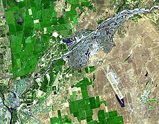
. The goldfields are noted for their otherworldly appearance, filled with oddly shaped gravel
Gravel
Gravel is composed of unconsolidated rock fragments that have a general particle size range and include size classes from granule- to boulder-sized fragments. Gravel can be sub-categorized into granule and cobble...
mountains, ravines, streams and turquoise-colored pools of water. From the air, the goldfields are said to resemble intestine
Intestine
In human anatomy, the intestine is the segment of the alimentary canal extending from the pyloric sphincter of the stomach to the anus and, in humans and other mammals, consists of two segments, the small intestine and the large intestine...
s.
Wild turkeys, deer, ducks, Beavers, heron
Heron
The herons are long-legged freshwater and coastal birds in the family Ardeidae. There are 64 recognised species in this family. Some are called "egrets" or "bitterns" instead of "heron"....
s, bald eagle
Bald Eagle
The Bald Eagle is a bird of prey found in North America. It is the national bird and symbol of the United States of America. This sea eagle has two known sub-species and forms a species pair with the White-tailed Eagle...
s, Northern river otter
Northern River Otter
The North American river otter , also known as the northern river otter or the common otter, is a semiaquatic mammal endemic to the North American continent, found in and along its waterways and coasts. An adult river otter can weigh between 5 and 14 kg...
s and even mountain lions now call the goldfields home.
History
They were created during the California Gold RushCalifornia Gold Rush
The California Gold Rush began on January 24, 1848, when gold was found by James W. Marshall at Sutter's Mill in Coloma, California. The first to hear confirmed information of the gold rush were the people in Oregon, the Sandwich Islands , and Latin America, who were the first to start flocking to...
. The first Yuba-area miners panned for gold
Gold
Gold is a chemical element with the symbol Au and an atomic number of 79. Gold is a dense, soft, shiny, malleable and ductile metal. Pure gold has a bright yellow color and luster traditionally considered attractive, which it maintains without oxidizing in air or water. Chemically, gold is a...
in stream beds in the valley but within a decade large-scale industrial processes replaced solitary prospectors. Mining
Mining
Mining is the extraction of valuable minerals or other geological materials from the earth, from an ore body, vein or seam. The term also includes the removal of soil. Materials recovered by mining include base metals, precious metals, iron, uranium, coal, diamonds, limestone, oil shale, rock...
companies moved from the valley floor into the Sierra Nevada foothills, where miners blasted gravel hillsides with high-pressure jets of water—a process called hydraulic mining
Hydraulic mining
Hydraulic mining, or hydraulicking, is a form of mining that uses high-pressure jets of water to dislodge rock material or move sediment. In the placer mining of gold or tin, the resulting water-sediment slurry is directed through sluice boxes to remove the gold.-Precursor - ground...
. After the miners extracted gold in long wooden sluice
Sluice
A sluice is a water channel that is controlled at its head by a gate . For example, a millrace is a sluice that channels water toward a water mill...
s, they dumped the gravel back into the mountain valleys. Rivers and streams carried the flood of sediment
Sediment
Sediment is naturally occurring material that is broken down by processes of weathering and erosion, and is subsequently transported by the action of fluids such as wind, water, or ice, and/or by the force of gravity acting on the particle itself....
—called slickens—down to the Sacramento Valley
Sacramento Valley
The Sacramento Valley is the portion of the California Central Valley that lies to the north of the San Joaquin-Sacramento Delta in the U.S. state of California. It encompasses all or parts of ten counties.-Geography:...
. Upwards of 685000000 cubic feet (19,397,040.2 m³) of debris was deposited in the Yuba River. The mine waste carried by the Yuba River ended up raising the riverbed (by up to 100 feet (30.5 m) in some cases), causing floods that buried farms east of the town of Marysville
Marysville, California
Marysville is the county seat of Yuba County, California, United States. The population was 12,072 at the 2010 census, down from 12,268 at the 2000 census. It is included in the Yuba City Metropolitan Statistical Area, often referred to as the Yuba-Sutter Area after the two counties, Yuba and...
with gravel, mud, as well as mercury
Mercury (element)
Mercury is a chemical element with the symbol Hg and atomic number 80. It is also known as quicksilver or hydrargyrum...
and arsenic
Arsenic
Arsenic is a chemical element with the symbol As, atomic number 33 and relative atomic mass 74.92. Arsenic occurs in many minerals, usually in conjunction with sulfur and metals, and also as a pure elemental crystal. It was first documented by Albertus Magnus in 1250.Arsenic is a metalloid...
(byproducts of the mining process). As the Yuba River is a tributary of the Sacramento River
Sacramento River
The Sacramento River is an important watercourse of Northern and Central California in the United States. The largest river in California, it rises on the eastern slopes of the Klamath Mountains, and after a journey south of over , empties into Suisun Bay, an arm of the San Francisco Bay, and...
, much of that debris then found its way to the San Francisco Bay
San Francisco Bay
San Francisco Bay is a shallow, productive estuary through which water draining from approximately forty percent of California, flowing in the Sacramento and San Joaquin rivers from the Sierra Nevada mountains, enters the Pacific Ocean...
. In Sacramento
Sacramento, California
Sacramento is the capital city of the U.S. state of California and the county seat of Sacramento County. It is located at the confluence of the Sacramento River and the American River in the northern portion of California's expansive Central Valley. With a population of 466,488 at the 2010 census,...
, the I Street Bridge
I Street Bridge
The I Street Bridge is a historic metal truss swing bridge located on I Street in Sacramento, California crossing the Sacramento River connecting Yolo County with Sacramento County...
had to be raised twenty feet (6 m). Lawsuit
Lawsuit
A lawsuit or "suit in law" is a civil action brought in a court of law in which a plaintiff, a party who claims to have incurred loss as a result of a defendant's actions, demands a legal or equitable remedy. The defendant is required to respond to the plaintiff's complaint...
s by farmers curtailed hydraulic mining in 1883, but the gravel remained behind in the Yuba Goldfields.
In 1893, the California Debris Commission began to dredge
Dredge
Dredging is an excavation activity or operation usually carried out at least partly underwater, in shallow seas or fresh water areas with the purpose of gathering up bottom sediments and disposing of them at a different location...
the Yuba near Marysville to mitigate the environmental damage, and piled the gravel along the river's banks, creating the irregular hills seen today. The dredgers also created over 200 ponds, which are fed by a network of underground rivers, which in turn were formed due to the porosity
Porosity
Porosity or void fraction is a measure of the void spaces in a material, and is a fraction of the volume of voids over the total volume, between 0–1, or as a percentage between 0–100%...
of the ground. The water in these ponds is usually clear blue, the impurities having been filtered by the gravel.
In the twentieth century, a series of mining companies reprocessed the slickens, extracting gold that was increasingly difficult to separate from the gravel. Even though the ore had already been processed, it was the principal source of gold in California for some time. By the 1970s, it was economically impossible to retrieve any more gold, and the debris became a source of aggregate
Aggregate (composite)
Aggregate is the component of a composite material that resists compressive stress and provides bulk to the composite material. For efficient filling, aggregate should be much smaller than the finished item, but have a wide variety of sizes...
, an essential ingredient of concrete
Concrete
Concrete is a composite construction material, composed of cement and other cementitious materials such as fly ash and slag cement, aggregate , water and chemical admixtures.The word concrete comes from the Latin word...
. It has been estimated that up to $15 billion worth of aggregate lies within the goldfields, although the mining industry disputes this figure.
The environmental damage caused by the dredgers is enormous. The top 150 feet (45.7 m) of many square miles was turned upside-down. The soil and the rocks were separated with the rocks stacked on top of the soil.
Land controversy
The goldfields are the subject of an ongoing dispute as to land titleTitle (property)
Title is a legal term for a bundle of rights in a piece of property in which a party may own either a legal interest or an equitable interest. The rights in the bundle may be separated and held by different parties. It may also refer to a formal document that serves as evidence of ownership...
and access. Much of the land is owned by Western Aggregate, a mining company extracting gravel from the goldfields. The remainder of the land is split between small private owners, the Bureau of Land Management
Bureau of Land Management
The Bureau of Land Management is an agency within the United States Department of the Interior which administers America's public lands, totaling approximately , or one-eighth of the landmass of the country. The BLM also manages of subsurface mineral estate underlying federal, state and private...
, and the United States Army Corps of Engineers
United States Army Corps of Engineers
The United States Army Corps of Engineers is a federal agency and a major Army command made up of some 38,000 civilian and military personnel, making it the world's largest public engineering, design and construction management agency...
.
The BLM land is free for the public to use for recreational purposes, but much of it is actually unreachable. Some of it can be accessed via boats on the river, but other access roads have been closed off by Western Aggregate. The parcel of land owned by the Army Corps is technically public land, but it is also inaccessible and it is closed for recreation. Western Aggregate owns mining rights over much (but not all) of that property.
The titles themselves are also under much dispute because mining has so shifted the landscape of gravel as well as the river itself that it has become unclear as to what the property boundaries are.
In response to the blocking of Hammonton Road, a county road, into the Yuba Goldfields, the Yuba Goldfields Access Coalition was formed in 1996 by local historian Chuck Smith. Smith, along with Goldfields residents and 80 members of the community, spent the next 10 years fighting for public access by educating the public that the road had been public since 1850, when it was used by gold miners. Dozens of members of the coalition were arrested for trespassing on the public road, although none was convicted. In 2000, Yuba County Superior Court Judge Dave Wasilenko ruled that Hammonton Road was a public road, a decision ultimately upheld by the California Supreme Court.
The hunting and fishing rights for the majority of the Goldfields belong to a private group called Wildtoo LLC. Unfortunately hundreds of area residents poach the Goldfields each month. Section 27 is a BLM parcel that gets most of the use. Private and public lands are still hard for members of the public to distinguish. In August 2006, the Bureau of Land Management issued a record of decision to enter into a 20-year lease to allow a heavy equipment operator training center in the Yuba Goldfields. Western Aggregates, the subsidiary of a Texas mining company, has appealed the decision, which could delay construction of the school for up to two years.
Possible nature reserve
There is currently a movement to establish a nature reserveNature reserve
A nature reserve is a protected area of importance for wildlife, flora, fauna or features of geological or other special interest, which is reserved and managed for conservation and to provide special opportunities for study or research...
on the lower Yuba River, which would include portions of the Yuba Goldfields. However, sorting out the land issue could take years. Creating a reserve would also require a large amount of money, but the aggregate could cover much if not all of that.