

Xinovrysi
Encyclopedia
Xinovrysi is a Greek
village located near Argalasti
in the Pelion
area in the Magnesia
prefecture. Xinovrysi is connected with a road linking with Trikeri
and the GR-34. Xinovrysi is part of the municipal unit of Argalasti
. Its population in 2001 was 161.
 The older name of the town was Bistinika (Μπιστινίκα) or Bestinika (Μπεστινίκα). The historian Yannis Kordatos describes the origin of the name Bistinika that comes from the Slavic word pestinik or pecnik which means oven
. Other think that the origin of the previous name came from the Greek word for narrow, one of its areas are built in a narrow area that are filled with two and three hilltops.
During the Ottoman Period
, Bistinika was the mahala of Argalasti
. In the mid-19th century, the village had 65 to 80 homes and it had around 325 persons and lived off olive, wine, figs and other types of agriculture. The village has never lived off prosperity and it didn't had a school. The village was destroyed first during the Greek War of Independence
in 1821 and 1823 which devastated the entire village by the Turks, in 1854 and in 1878.
The village finally became Greek
after the liberation of Thessaly
in 1881. Bistinika became a part of the municipality of Spalathra, it had an area which in Argalasti and others except for Argalasti and Bistinikas - it had Metochi, Bir [Μπιρ] (now Kallithea) and Ski [Σκι] (now Syki).
In 1994, Bistinika became an autonomous commune and opened its first school. Later, the name officially changed to its present name of Xinovrysi. The new name which comes from the name of the springs (natural spring). Th ename of the town rarely known with two ys (as Xynovrysi). Today, its nearby stream are mainly destroyed.
After the difficult wartime periods of World War II
and the Greek Civil War
, the population begam to tumble and decline, many of its inhabitants left for larger towns and cities including Volos
and other parts of the world.
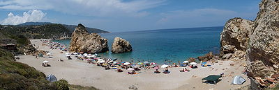
Its nearby beaches at the Aegean Sea
, are Mourtitsa, Potistika, Kourites and Melani. In the 1970s, the area began its tourism by introducing hotels and restaurants. Its local school shut down in the 1990s.
In late-August 1995, the beautiful area of Xinovrysi with its olives and its pines suffered a forest fire. With the Kapodistria Law (L. 2539/1997) in 1998, Xinovrysi became a municipal district of the new municipality of Argalasti. The remaining inhabitants still live off with agriculture and revive a part of its tourism.
For a summer torp, many head to the beautiful beaches of Xinovrysis, Mourtitsa, Potistika and Melani which is located around 5 km from the village and is accessed with a paved road. Potiatika is a small settlement which works as a camping settlement. At the town square features café shops.
), its nearest school, lyceum (middle school) and gymnasium (secondary school) are in Argalasti.
Greece
Greece , officially the Hellenic Republic , and historically Hellas or the Republic of Greece in English, is a country in southeastern Europe....
village located near Argalasti
Argalasti
Argalasti is a village and a former municipality in Magnesia, Thessaly, Greece. Since the 2011 local government reform it is part of the municipality South Pelion, of which it is the seat and a municipal unit. It is built on a fertile plateau, 40 km southeast of Volos. It is an important...
in the Pelion
Pelion
Pelion or Pelium is a mountain at the southeastern part of Thessaly in central Greece, forming a hook-like peninsula between the Pagasetic Gulf and the Aegean Sea...
area in the Magnesia
Magnesia Prefecture
Magnesia Prefecture was one of the prefectures of Greece. Its capital was Volos. It was established in 1899 from the Larissa Prefecture. The prefecture was disbanded on 1 January 2011 by the Kallikratis programme, and split into the peripheral units of Magnesia and the Sporades.The toponym is...
prefecture. Xinovrysi is connected with a road linking with Trikeri
Trikeri
Trikeri is a town and a former community in Magnesia, Thessaly, Greece. Since the 2011 local government reform it is part of the municipality South Pelion, of which it is a municipal unit. It lies at the westernmost point of the hook-like Pelion Peninsula on the Pagasetic Gulf. It also includes...
and the GR-34. Xinovrysi is part of the municipal unit of Argalasti
Argalasti
Argalasti is a village and a former municipality in Magnesia, Thessaly, Greece. Since the 2011 local government reform it is part of the municipality South Pelion, of which it is the seat and a municipal unit. It is built on a fertile plateau, 40 km southeast of Volos. It is an important...
. Its population in 2001 was 161.
Population
| Year | Village population | Municipal district population |
|---|---|---|
| mid-19th century | 325 | - |
| 1981 | 306 | - |
| 1991 | 208 | - |
| 2001 | 161 | 199 |
History
Oven
An oven is a thermally insulated chamber used for the heating, baking or drying of a substance. It is most commonly used for cooking. Kilns, and furnaces are special-purpose ovens...
. Other think that the origin of the previous name came from the Greek word for narrow, one of its areas are built in a narrow area that are filled with two and three hilltops.
During the Ottoman Period
Ottoman Empire
The Ottoman EmpireIt was usually referred to as the "Ottoman Empire", the "Turkish Empire", the "Ottoman Caliphate" or more commonly "Turkey" by its contemporaries...
, Bistinika was the mahala of Argalasti
Argalasti
Argalasti is a village and a former municipality in Magnesia, Thessaly, Greece. Since the 2011 local government reform it is part of the municipality South Pelion, of which it is the seat and a municipal unit. It is built on a fertile plateau, 40 km southeast of Volos. It is an important...
. In the mid-19th century, the village had 65 to 80 homes and it had around 325 persons and lived off olive, wine, figs and other types of agriculture. The village has never lived off prosperity and it didn't had a school. The village was destroyed first during the Greek War of Independence
Greek War of Independence
The Greek War of Independence, also known as the Greek Revolution was a successful war of independence waged by the Greek revolutionaries between...
in 1821 and 1823 which devastated the entire village by the Turks, in 1854 and in 1878.
The village finally became Greek
Greece
Greece , officially the Hellenic Republic , and historically Hellas or the Republic of Greece in English, is a country in southeastern Europe....
after the liberation of Thessaly
Thessaly
Thessaly is a traditional geographical region and an administrative region of Greece, comprising most of the ancient region of the same name. Before the Greek Dark Ages, Thessaly was known as Aeolia, and appears thus in Homer's Odyssey....
in 1881. Bistinika became a part of the municipality of Spalathra, it had an area which in Argalasti and others except for Argalasti and Bistinikas - it had Metochi, Bir [Μπιρ] (now Kallithea) and Ski [Σκι] (now Syki).
In 1994, Bistinika became an autonomous commune and opened its first school. Later, the name officially changed to its present name of Xinovrysi. The new name which comes from the name of the springs (natural spring). Th ename of the town rarely known with two ys (as Xynovrysi). Today, its nearby stream are mainly destroyed.
After the difficult wartime periods of World War II
World War II
World War II, or the Second World War , was a global conflict lasting from 1939 to 1945, involving most of the world's nations—including all of the great powers—eventually forming two opposing military alliances: the Allies and the Axis...
and the Greek Civil War
Greek Civil War
The Greek Civil War was fought from 1946 to 1949 between the Greek governmental army, backed by the United Kingdom and United States, and the Democratic Army of Greece , the military branch of the Greek Communist Party , backed by Bulgaria, Yugoslavia and Albania...
, the population begam to tumble and decline, many of its inhabitants left for larger towns and cities including Volos
Volos
Volos is a coastal port city in Thessaly situated midway on the Greek mainland, about 326 km north of Athens and 215 km south of Thessaloniki...
and other parts of the world.
Its nearby beaches at the Aegean Sea
Aegean Sea
The Aegean Sea[p] is an elongated embayment of the Mediterranean Sea located between the southern Balkan and Anatolian peninsulas, i.e., between the mainlands of Greece and Turkey. In the north, it is connected to the Marmara Sea and Black Sea by the Dardanelles and Bosporus...
, are Mourtitsa, Potistika, Kourites and Melani. In the 1970s, the area began its tourism by introducing hotels and restaurants. Its local school shut down in the 1990s.
In late-August 1995, the beautiful area of Xinovrysi with its olives and its pines suffered a forest fire. With the Kapodistria Law (L. 2539/1997) in 1998, Xinovrysi became a municipal district of the new municipality of Argalasti. The remaining inhabitants still live off with agriculture and revive a part of its tourism.
For a summer torp, many head to the beautiful beaches of Xinovrysis, Mourtitsa, Potistika and Melani which is located around 5 km from the village and is accessed with a paved road. Potiatika is a small settlement which works as a camping settlement. At the town square features café shops.
Other
Xinovrysi has a church, and a square (plateiaPlateia
Plateia or platia is the Greek word for town square. Most Greek and Cypriot cities have several town squares which are a point of reference in travelling and guiding...
), its nearest school, lyceum (middle school) and gymnasium (secondary school) are in Argalasti.