
Wyalusing State Park
Encyclopedia
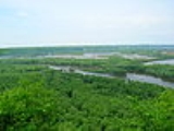
Wyalusing State Park is a 2628 acres (1,063.5 ha) Wisconsin
state park at the confluence of the Mississippi
and Wisconsin River
s in the town of Wyalusing
, just south of Prairie du Chien
. Wyalusing means "home of the warrior" in the Lenape language
spoken by Munsee-Delaware
Indians who settled in the area in the 19th century after being displaced from farther east. 500 feet (152.4 m) high bluffs dotted with prehistoric Indian mounds look out over the river valleys.
The park is in the Driftless Area of Wisconsin, a portion of territory that remained ice free during the last ice age
, while land to the east and west was crushed by glaciers. The high bluffs along the Mississippi River and the large deep canyon of the Wisconsin River are evidence of glacial meltwaters reshaping this region.
Wisconsin
Wisconsin is a U.S. state located in the north-central United States and is part of the Midwest. It is bordered by Minnesota to the west, Iowa to the southwest, Illinois to the south, Lake Michigan to the east, Michigan to the northeast, and Lake Superior to the north. Wisconsin's capital is...
state park at the confluence of the Mississippi
Mississippi River
The Mississippi River is the largest river system in North America. Flowing entirely in the United States, this river rises in western Minnesota and meanders slowly southwards for to the Mississippi River Delta at the Gulf of Mexico. With its many tributaries, the Mississippi's watershed drains...
and Wisconsin River
Wisconsin River
-External links:* * * , Wisconsin Historical Society* * * *...
s in the town of Wyalusing
Wyalusing, Wisconsin
Wyalusing is a town in Grant County, Wisconsin, United States. The population was 370 at the 2000 census. The unincorporated communities of Brodtville and Wyalusing are located in the town.-Geography:...
, just south of Prairie du Chien
Prairie du Chien, Wisconsin
Prairie du Chien is a city in and the county seat of Crawford County, Wisconsin, United States. The population was 5,911 at the 2010 census. Its Zip Code is 53821....
. Wyalusing means "home of the warrior" in the Lenape language
Lenape language
The Delaware languages, also known as the Lenape languages, are Munsee and Unami, two closely related languages of the Eastern Algonquian subgroup of the Algonquian language family...
spoken by Munsee-Delaware
Lenape
The Lenape are an Algonquian group of Native Americans of the Northeastern Woodlands. They are also called Delaware Indians. As a result of the American Revolutionary War and later Indian removals from the eastern United States, today the main groups live in Canada, where they are enrolled in the...
Indians who settled in the area in the 19th century after being displaced from farther east. 500 feet (152.4 m) high bluffs dotted with prehistoric Indian mounds look out over the river valleys.
The park is in the Driftless Area of Wisconsin, a portion of territory that remained ice free during the last ice age
Wisconsin glaciation
The last glacial period was the most recent glacial period within the current ice age occurring during the last years of the Pleistocene, from approximately 110,000 to 10,000 years ago....
, while land to the east and west was crushed by glaciers. The high bluffs along the Mississippi River and the large deep canyon of the Wisconsin River are evidence of glacial meltwaters reshaping this region.
External links
- Wyalusing State Park official website
- Friends of Wyalusing State Park