
Wreck Beach
Encyclopedia
Wreck Beach is a popular clothing-optional beach
located in Pacific Spirit Regional Park
, which is in turn part of the University Endowment Lands
just west of Vancouver
, British Columbia
, Canada
. The clothing-optional section is clearly marked with signs and stretches approximately 6.7 km from Acadia Beach, in the north, to the Booming Grounds Creek on the north arm of the Fraser River. The park is administered by the Greater Vancouver Regional District
(GVRD), though aboriginal claims are repeatedly asserted, especially by the Musqueam.
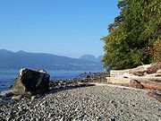
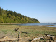
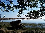
The shoreline throughout these beaches is mainly rocky with some sandy stretches with fewer beach-goers. An area is provided for owners to have their dogs off leash. During the smelt season, naturists share this area with clothed fishers and their families. Smelt fishing is typically prohibited from the middle of June to the middle of August.
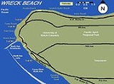
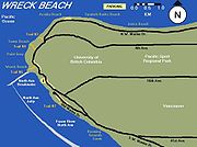
Acadia Beach is short walk down a gentle slope from the parking lot on Marine Drive where there is a grassy area with several picnic tables. Tower Beach is at the end of the much longer Trail 3 and Point Grey is near the steeper Trail 4. There is pay parking close to Trail 3 and 4 at the Museum of Anthropology. All of Wreck Beach is contiguous and it is possible to walk along the entire coastline. However, when the tide is too high, access can be limited.
Along Tower Beach are two tall concrete range/direction instrument towers that are relics from World War II
.
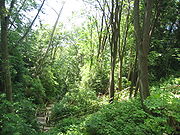
Along with lush vegetation, various forms of wildlife can also be seen, including nesting herons, sea lions, kingfishers, and bald eagles.

 While the entire 7 km beach around to Point Grey from Acadia Beach to Booming Ground Creek is often referred to as Wreck Beach, the large sandy area on the north side of the North Arm Breakwater at the base of Trail 6 is what many think of when they talk about Wreck Beach. The trail is the most developed of the trails down the bluff and consists of 542 wooden steps. This section of the beach is the most heavily used. At the bottom you will find a stretch of sand between two artificial rock jetties as a water breaks lined by a row of licensed vendors selling imported clothing, jewelry, drinks, snacks, and other beach related items. Other unlicensed vendors may be found wander the beach selling alcoholic beverages and other more illicit cash crops of British Columbia.
Nudity is optional throughout Wreck Beach; however, regular beach-goers consider it good etiquette to join the unclothed rather than just observe them. Additionally, due to Wreck Beach's proximity to the University of British Columbia
, many students and even faculty, can be found at Wreck Beach. In recent years many beach users have objected, on both privacy and environmental grounds, to the University's plans to construct new buildings too close to the cliff edge and partially overlooking the beach.
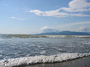
 The trail has recently been improved with the addition of handrails and better stairs. The ocean here was stagnant and polluted - however changes in booming practices have helped to revive the balance and water is now considered suitable for swimming.
At the bottom of the trail one can choose to go right (northwest) or left (southeast). There are several sandy spits several hundred meters to the northwest. There are numerous small pockets of sand along the trail in both directions. There are also a number of small trails, all along this area. The estuary area to the North is known as the Oasis.
 Wreck Beach adjoins the University of British Columbia
(UBC) campus, west of the city limits of Vancouver. It is accessible by road, water, and public buses. The most popular part, Trail 6, is 3 km overland from Vancouver.
TransLink runs a number of bus routes (4, 9, 17, 25, 33, 41, 43, 44, 49, 84, 99, 258, and 480) to the UBC bus loop. From there it is a five-minute walk west, down University Boulevard, to UBC Gate 6 (from which Trail 6 takes it name). Turn right on N.W. Marine Drive and the trail is immediately to the left about 100 meters.
From Highway 99, turn west on one of these roads: S.W. Marine Drive, 41st Avenue (which eventually merges onto S.W. Marine Drive) or 16th Avenue (which eventually ends at S.W. Marine Drive, then turn right). Alternatively, from the north only, take the 4th Avenue exit off the Granville Street Bridge
(then from 4th Avenue, turn right on N.W. Marine Drive).
From Highway 1, take the Grandview Highway exit (28A) westbound (this eventually becomes 12th Avenue), turn right (north) on Clark Drive, left again (west) on 6th Avenue (this eventually becomes 4th Avenue), and then turn right on N.W. Marine Drive.
Wreck Beach lies at the base of a cliff; therefore the trails are fairly steep. Trail 6 and Trail 7 both have stairs. Trail 6 has 473 counted steps from the top to the bottom and is the better developed of the two trails. The path from the Acadia Beach parking lot is the most gentle slope and provides the easiest access to a clothing-optional area. When the tide is not too high, it is possible to walk along the entire shore: from Acadia Beach past the base of Trail 7. Erosion can make the route south of Trail 6 a bit tricky, and it can often be quite muddy.
 There is a small parking lot at Acadia Beach, a pay parking lot south of Trail 6 and several pay parking lots on the UBC campus. Free parking is also allowed all along the east side of S.W. Marine Drive (opposite the cliff side) and along Old Marine Drive. Illegally parked vehicles are often towed away.
s at the base of Trail 6. There is no running water, so many visitors bring their own. A few times over the years, the Metro Vancouver health authorities have issued warnings that the beach Coliform counts are too contaminated for swimming- however for the most part, Wreck Beach tends to have a lower count than many Vancouver Beaches.
Nude beach
A nude beach is a beach where users are legally at liberty to be nude. Sometimes the terms clothing-optional beach or free beach are used. Nude bathing is one of the most common forms of nudity in public. As beaches are usually on public lands, any member of the public is entitled to use the...
located in Pacific Spirit Regional Park
Pacific Spirit Regional Park
Pacific Spirit Regional Park is located in the University Endowment Lands, on Point Grey to the west of the city of Vancouver, British Columbia. It surrounds the endowment lands of the University of British Columbia on the shores of Georgia Strait in the Pacific Ocean...
, which is in turn part of the University Endowment Lands
University Endowment Lands
The University Endowment Lands is an unincorporated area that lies to the west of the city of Vancouver, British Columbia, Canada surrounding the University of British Columbia...
just west of Vancouver
Vancouver
Vancouver is a coastal seaport city on the mainland of British Columbia, Canada. It is the hub of Greater Vancouver, which, with over 2.3 million residents, is the third most populous metropolitan area in the country,...
, British Columbia
British Columbia
British Columbia is the westernmost of Canada's provinces and is known for its natural beauty, as reflected in its Latin motto, Splendor sine occasu . Its name was chosen by Queen Victoria in 1858...
, Canada
Canada
Canada is a North American country consisting of ten provinces and three territories. Located in the northern part of the continent, it extends from the Atlantic Ocean in the east to the Pacific Ocean in the west, and northward into the Arctic Ocean...
. The clothing-optional section is clearly marked with signs and stretches approximately 6.7 km from Acadia Beach, in the north, to the Booming Grounds Creek on the north arm of the Fraser River. The park is administered by the Greater Vancouver Regional District
Greater Vancouver Regional District
Metro Vancouver is the brand name of the board of the inter-municipal administrative body known as the Greater Vancouver Regional District , a regional district in British Columbia, Canada...
(GVRD), though aboriginal claims are repeatedly asserted, especially by the Musqueam.
Acadia Beach - Tower Beach - Point Grey
The shoreline throughout these beaches is mainly rocky with some sandy stretches with fewer beach-goers. An area is provided for owners to have their dogs off leash. During the smelt season, naturists share this area with clothed fishers and their families. Smelt fishing is typically prohibited from the middle of June to the middle of August.
Acadia Beach is short walk down a gentle slope from the parking lot on Marine Drive where there is a grassy area with several picnic tables. Tower Beach is at the end of the much longer Trail 3 and Point Grey is near the steeper Trail 4. There is pay parking close to Trail 3 and 4 at the Museum of Anthropology. All of Wreck Beach is contiguous and it is possible to walk along the entire coastline. However, when the tide is too high, access can be limited.
Along Tower Beach are two tall concrete range/direction instrument towers that are relics from World War II
World War II
World War II, or the Second World War , was a global conflict lasting from 1939 to 1945, involving most of the world's nations—including all of the great powers—eventually forming two opposing military alliances: the Allies and the Axis...
.
Along with lush vegetation, various forms of wildlife can also be seen, including nesting herons, sea lions, kingfishers, and bald eagles.
Wreck Beach proper
Nudity is optional throughout Wreck Beach; however, regular beach-goers consider it good etiquette to join the unclothed rather than just observe them. Additionally, due to Wreck Beach's proximity to the University of British Columbia
University of British Columbia
The University of British Columbia is a public research university. UBC’s two main campuses are situated in Vancouver and in Kelowna in the Okanagan Valley...
, many students and even faculty, can be found at Wreck Beach. In recent years many beach users have objected, on both privacy and environmental grounds, to the University's plans to construct new buildings too close to the cliff edge and partially overlooking the beach.
Trail 7
At the bottom of the trail one can choose to go right (northwest) or left (southeast). There are several sandy spits several hundred meters to the northwest. There are numerous small pockets of sand along the trail in both directions. There are also a number of small trails, all along this area. The estuary area to the North is known as the Oasis.
Access
University of British Columbia
The University of British Columbia is a public research university. UBC’s two main campuses are situated in Vancouver and in Kelowna in the Okanagan Valley...
(UBC) campus, west of the city limits of Vancouver. It is accessible by road, water, and public buses. The most popular part, Trail 6, is 3 km overland from Vancouver.
TransLink runs a number of bus routes (4, 9, 17, 25, 33, 41, 43, 44, 49, 84, 99, 258, and 480) to the UBC bus loop. From there it is a five-minute walk west, down University Boulevard, to UBC Gate 6 (from which Trail 6 takes it name). Turn right on N.W. Marine Drive and the trail is immediately to the left about 100 meters.
From Highway 99, turn west on one of these roads: S.W. Marine Drive, 41st Avenue (which eventually merges onto S.W. Marine Drive) or 16th Avenue (which eventually ends at S.W. Marine Drive, then turn right). Alternatively, from the north only, take the 4th Avenue exit off the Granville Street Bridge
Granville Street Bridge
The Granville Street Bridge is an eight lane bridge in Vancouver, British Columbia. It spans False Creek and is 27.4 metres above Granville Island. It is part of Highway 99.-History:...
(then from 4th Avenue, turn right on N.W. Marine Drive).
From Highway 1, take the Grandview Highway exit (28A) westbound (this eventually becomes 12th Avenue), turn right (north) on Clark Drive, left again (west) on 6th Avenue (this eventually becomes 4th Avenue), and then turn right on N.W. Marine Drive.
Wreck Beach lies at the base of a cliff; therefore the trails are fairly steep. Trail 6 and Trail 7 both have stairs. Trail 6 has 473 counted steps from the top to the bottom and is the better developed of the two trails. The path from the Acadia Beach parking lot is the most gentle slope and provides the easiest access to a clothing-optional area. When the tide is not too high, it is possible to walk along the entire shore: from Acadia Beach past the base of Trail 7. Erosion can make the route south of Trail 6 a bit tricky, and it can often be quite muddy.
Parking
Toilets
The GVRD provides limited sanitary facilities. There are outhouses by the Acadia Beach parking lot and at the tops of Trails 6 and 7 and there are also portable toiletPortable toilet
Portable toilet are simple portable enclosures containing a chemical toilet which are typically used as a temporary toilet for construction sites and large gatherings and events. Most of the portable toilets have black open-front-U-shaped toilet seat with cover...
s at the base of Trail 6. There is no running water, so many visitors bring their own. A few times over the years, the Metro Vancouver health authorities have issued warnings that the beach Coliform counts are too contaminated for swimming- however for the most part, Wreck Beach tends to have a lower count than many Vancouver Beaches.
See also
- Clothes free organizations
- List of public outdoor clothes free places
- NaturismNaturismNaturism or nudism is a cultural and political movement practising, advocating and defending social nudity in private and in public. It may also refer to a lifestyle based on personal, family and/or social nudism....
- Nudism
- Public nudityPublic nudityPublic nudity or nude in public refers to nudity not in an entirely private context. It refers to a person appearing nude in a public place or to be seen from a public place. It also includes nudity in a semi-public place, where the general public is free to enter, such as a shopping mall...
Further reading
- Carellin Brooks, Wreck Beach (book), Number 16 in the Transmontanus series from New Star Books, Vancouver, British Columbia, Canada; www.NewStarBooks.com. Issued 2007 August. ISBN 978-1-55420-031-3; ISSN 1200-3336 Number 16.
External links
- Pacific Spirit Regional Park
- Translink (Vancouver and area bus information)
- Wreck Beach Preservation Society
- Wreck Beach Butoh Art Film