
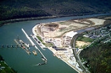
Winfield, West Virginia
Encyclopedia

Putnam County, West Virginia
As of the census of 2000, there were 51,589 people, 20,028 households, and 15,281 families residing in the county. The population density was 149 people per square mile . There were 21,621 housing units at an average density of 62 per square mile...
, West Virginia
West Virginia
West Virginia is a state in the Appalachian and Southeastern regions of the United States, bordered by Virginia to the southeast, Kentucky to the southwest, Ohio to the northwest, Pennsylvania to the northeast and Maryland to the east...
, along the Kanawha River
Kanawha River
The Kanawha River is a tributary of the Ohio River, approximately 97 mi long, in the U.S. state of West Virginia. The largest inland waterway in West Virginia, it has formed a significant industrial region of the state since the middle of the 19th century.It is formed at the town of Gauley...
. The population was 2,301 at the 2010 census. It is the county seat
County seat
A county seat is an administrative center, or seat of government, for a county or civil parish. The term is primarily used in the United States....
of Putnam County
Putnam County, West Virginia
As of the census of 2000, there were 51,589 people, 20,028 households, and 15,281 families residing in the county. The population density was 149 people per square mile . There were 21,621 housing units at an average density of 62 per square mile...
.
Winfield was established on a 400 acres (161.9 ha) tract of land owned by Charles Brown. He established a ferry
Ferry
A ferry is a form of transportation, usually a boat, but sometimes a ship, used to carry primarily passengers, and sometimes vehicles and cargo as well, across a body of water. Most ferries operate on regular, frequent, return services...
across the river in 1818. The first meeting of the county court was held at the home of Talleyrand P. Brown, in Winfield, on May 22, 1848. The town was incorporated
Municipal corporation
A municipal corporation is the legal term for a local governing body, including cities, counties, towns, townships, charter townships, villages, and boroughs. Municipal incorporation occurs when such municipalities become self-governing entities under the laws of the state or province in which...
on February 21, 1868, and named in honor of Winfield Scott
Winfield Scott
Winfield Scott was a United States Army general, and unsuccessful presidential candidate of the Whig Party in 1852....
, the commanding general
General
A general officer is an officer of high military rank, usually in the army, and in some nations, the air force. The term is widely used by many nations of the world, and when a country uses a different term, there is an equivalent title given....
of the U.S. Army
United States Army
The United States Army is the main branch of the United States Armed Forces responsible for land-based military operations. It is the largest and oldest established branch of the U.S. military, and is one of seven U.S. uniformed services...
during the Mexican–American War
Mexican–American War
The Mexican–American War, also known as the First American Intervention, the Mexican War, or the U.S.–Mexican War, was an armed conflict between the United States and Mexico from 1846 to 1848 in the wake of the 1845 U.S...
.
Geography
Winfield is located at 38°32′4"N 81°53′32"W (38.534455, -81.892206).According to the United States Census Bureau
United States Census Bureau
The United States Census Bureau is the government agency that is responsible for the United States Census. It also gathers other national demographic and economic data...
, the town has a total area of 2.7 square miles (7 km²), or which 0.04 square mile (0.1035995244 km²), or 1.11%, is water.
Demographics
As of the censusCensus
A census is the procedure of systematically acquiring and recording information about the members of a given population. It is a regularly occurring and official count of a particular population. The term is used mostly in connection with national population and housing censuses; other common...
of 2000, there were 1,858 people, 736 households, and 563 families residing in the town. The population density
Population density
Population density is a measurement of population per unit area or unit volume. It is frequently applied to living organisms, and particularly to humans...
was 694.6 inhabitants per square mile (268.7/km²). There were 777 housing units at an average density of 290.5 per square mile (112.4/km²). The racial makeup of the town was 99.19% White, 0.22% African American, 0.27% Native American, 0.22% Asian, and 0.11% from two or more races. Hispanic or Latino of any race were 0.43% of the population.
There were 736 households out of which 39.0% had children under the age of 18 living with them, 65.1% were married couples
Marriage
Marriage is a social union or legal contract between people that creates kinship. It is an institution in which interpersonal relationships, usually intimate and sexual, are acknowledged in a variety of ways, depending on the culture or subculture in which it is found...
living together, 9.5% had a female householder with no husband present, and 23.5% were non-families. 20.8% of all households were made up of individuals and 7.3% had someone living alone who was 65 years of age or older. The average household size was 2.52 and the average family size was 2.92.
In the town the population was spread out with 25.8% under the age of 18, 6.0% from 18 to 24, 32.2% from 25 to 44, 25.9% from 45 to 64, and 10.1% who were 65 years of age or older. The median age was 38 years. For every 100 females there were 90.2 males. For every 100 females age 18 and over, there were 86.7 males.
The median income for a household in the town was $51,023, and the median income for a family was $59,196. Males had a median income of $43,885 versus $29,667 for females. The per capita income
Per capita income
Per capita income or income per person is a measure of mean income within an economic aggregate, such as a country or city. It is calculated by taking a measure of all sources of income in the aggregate and dividing it by the total population...
for the town was $23,564. About 4.5% of families and 4.9% of the population were below the poverty line, including 1.9% of those under age 18 and 5.2% of those age 65 or over.