

Windy Canyon
Encyclopedia
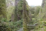
Canyon
A canyon or gorge is a deep ravine between cliffs often carved from the landscape by a river. Rivers have a natural tendency to reach a baseline elevation, which is the same elevation as the body of water it will eventually drain into. This forms a canyon. Most canyons were formed by a process of...
and associated walking track
Trail
A trail is a path with a rough beaten or dirt/stone surface used for travel. Trails may be for use only by walkers and in some places are the main access route to remote settlements...
on Great Barrier Island
Great Barrier Island
Great Barrier Island is a large island of New Zealand, situated to the north-east of central Auckland in the outer Hauraki Gulf. With an area of it is the fourth-largest island of New Zealand's main chain of islands, with its highest point, Mount Hobson, rising...
, New Zealand
New Zealand
New Zealand is an island country in the south-western Pacific Ocean comprising two main landmasses and numerous smaller islands. The country is situated some east of Australia across the Tasman Sea, and roughly south of the Pacific island nations of New Caledonia, Fiji, and Tonga...
. Located in the centre east of the island, the canyon is a spectacular natural site, a wind funnel shaped from andesitic rock
Andesite
Andesite is an extrusive igneous, volcanic rock, of intermediate composition, with aphanitic to porphyritic texture. In a general sense, it is the intermediate type between basalt and dacite. The mineral assemblage is typically dominated by plagioclase plus pyroxene and/or hornblende. Magnetite,...
. The canyon perches on one of the highest stretches of the island, less than 200 m below the 621 m summit of Mount Hobson
Mount Hobson, Great Barrier Island
Mount Hobson is the highest mountain on Great Barrier Island, New Zealand. Located in the centre of the island, it rises above sea level....
(the highest point of the island). Spectacular views of the Okiwi and Awana lowlands (north, respectively south of the canyon) can be had from it.
Palmers Track winds through the canyon, with the first part of the track (rising from the Okiwi-Claris road in the east) being boardwalk
Boardwalk
A boardwalk, in the conventional sense, is a wooden walkway for pedestrians and sometimes vehicles, often found along beaches, but they are also common as paths through wetlands, coastal dunes, and other sensitive environments....
ed, and equipped with wooden stairs to allow easy access (15 minutes walk) into the most spectacular parts of the canyon and onto the ridge. From there, the track leads further west to Mount Hobson (Hirakimata). This part of Palmers Track is a medium-difficulty track (3-4 hours walk return).