

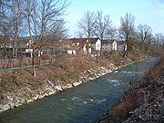
Wigger (river)
Encyclopedia
Switzerland
Switzerland name of one of the Swiss cantons. ; ; ; or ), in its full name the Swiss Confederation , is a federal republic consisting of 26 cantons, with Bern as the seat of the federal authorities. The country is situated in Western Europe,Or Central Europe depending on the definition....
cantons of Lucerne
Canton of Lucerne
Lucerne is a canton of Switzerland. It is located in the centre of Switzerland. The population of the canton is . , the population included 57,268 foreigners, or about 15.8% of the total population. The cantonal capital is Lucerne.-History:...
and Aargau
Aargau
Aargau is one of the more northerly cantons of Switzerland. It comprises the lower course of the river Aare, which is why the canton is called Aar-gau .-History:...
. It is an important tributary of the river Aar. The Wigger is around 41 kilometers long and flows from south to north for most of its length. The largest city in the Wigger valley is Zofingen
Zofingen
Zofingen is a city in the canton of Aargau in Switzerland. It is the capital of the district of Zofingen. Zofingen is a walled city and home of an ancient monastic settlement.-Geography:...
.
The river rises from the north slope of the Napf
Napf
Napf is a mountain on the border between the cantons of Berne and Lucerne. It is the summit of the Napfgebiet region, north of Bernese Alps.-Weather:...
in the canton of Lucerne near the border to the canton of Berne
Canton of Berne
The Canton of Bern is the second largest of the 26 Swiss cantons by both surface area and population. Located in west-central Switzerland, it borders the Canton of Jura and the Canton of Solothurn to the north. To the west lie the Canton of Neuchâtel, the Canton of Fribourg and Vaud. To the south...
in a height of about 1300 meters. There it is called Enziwigger. It flows through a narrow valley towards Hergiswil bei Willisau
Hergiswil bei Willisau
Hergiswil bei Willisau is a municipality in the district of Willisau in the canton of Lucerne in Switzerland.-Geography:Hergiswil bei Willisau has an area, , of . Of this area, 59.3% is used for agricultural purposes, while 36.6% is forested. Of the rest of the land, 3.5% is settled and the...
where the valley widens and flattens. Shortly after the small city of Willisau
Willisau
Willisau is a municipality in the district of Willisau in the Lucerne canton of Switzerland. It was formed on 1 January 2006 from the municipalities of Willisau Land and Willisau Stadt .-Foundation:...
it joins with the Buchwigger and is called just Wigger from there. The valley widens further to a flat and broad plain. North of Dagmersellen
Dagmersellen
Dagmersellen is a municipality in the district of Willisau in the canton of Lucerne in Switzerland.On 1 January 2006, the former municipalities of Buchs and Uffikon were merged into Dagmersellen, causing a one-third increase in its population and a marked increase in its territorial...
the Wigger is mostly restricted to a canal bed and flows partially parallel to the A2 motorway. Between Reiden
Reiden
Reiden is a municipality in the district of Willisau in the canton of Lucerne in Switzerland. On January 1, 2006 the former municipalities of Langnau bei Reiden and Richenthal were united in the new municipality of Reiden.-Geography:...
and Brittnau
Brittnau
Brittnau is a municipality in the district of Zofingen in the canton of Aargau in Switzerland.-Geography:Brittnau has an area, , of . Of this area, or 52.8% is used for agricultural purposes, while or 34.6% is forested...
it crosses the border to Aargau. It flows into the Aar between Rothrist
Rothrist
Rothrist is a municipality in the district of Zofingen in the canton of Aargau in Switzerland.-History:Originally an Alamanni settlement, the modern village of Rothrist is first mentioned in 1263 as Routris. The Herschaft rights were held by the Counts of Frohburg until 1299, when they...
and Aarburg
Aarburg
Aarburg is a municipality in the district of Zofingen in the canton of Aargau in Switzerland.The small town lies in the southwest Aargau at an Engnis Aare in the lower Wiggertal. It lies in the intersection of the most important traffic routes of Switzerland...
at a height of 395 meters.
Tributaries of the Wigger are the Seewag, the Wanger-Rot, the Ron, the Luthern and the Hürnbach.
In 1821 the Wigger's course was corrected (channelized) by order of the government of the canton of Aargau. Until the second half of the 19th century the area of the Wigger's confluence with the Aar was a location of placer mining
Placer mining
Placer mining is the mining of alluvial deposits for minerals. This may be done by open-pit or by various surface excavating equipment or tunneling equipment....
for gold, but this stopped due to dissatisfactory yield.