
Whixall
Encyclopedia
Whixall is a small and rural village and civil parish
in Shropshire
, England
.
The nearest towns are Whitchurch
, to the north, and Wem
, to the south.
The parish lies on the border with the county borough
of Wrexham
, Wales
. Its close proximity to Wales is shown by a hamlet called Welsh End
.
Within the parish boundaries are various hamlets including Abbey Green
. The Llangollen Canal
of the Shropshire Union Canal
, as well as the short Prees Branch of the Ellesmere Canal
, run through the parish.
 Prees was the intended destination of the Prees Branch, however the arm was only completed as far as Quina Brook
. The arm is now known as the Press Branch of the Llangollen Canal
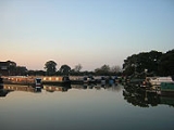
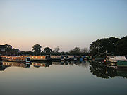
, and is navigavable for about a mile to Whixall Marina
, the following 3/4 mile is still followable on the towpath as it passes through Prees Branch Canal Nature Reserve
.
Adjacent to Whixall is Whixall Moss, part of Fenn's, Whixall and Bettisfield Mosses National Nature Reserve, the third largest lowland
raised bog
in Britain, a rare habitat and the home of a number of rare species.
The Shropshire Way
long distance footpath runs through Whixall.
Civil parish
In England, a civil parish is a territorial designation and, where they are found, the lowest tier of local government below districts and counties...
in Shropshire
Shropshire
Shropshire is a county in the West Midlands region of England. For Eurostat purposes, the county is a NUTS 3 region and is one of four counties or unitary districts that comprise the "Shropshire and Staffordshire" NUTS 2 region. It borders Wales to the west...
, England
England
England is a country that is part of the United Kingdom. It shares land borders with Scotland to the north and Wales to the west; the Irish Sea is to the north west, the Celtic Sea to the south west, with the North Sea to the east and the English Channel to the south separating it from continental...
.
The nearest towns are Whitchurch
Whitchurch, Shropshire
Whitchurch is a market town in Shropshire, England on the border between England and Wales. It is the oldest continuously inhabited town in Shropshire. According to the 2001 Census, the population of the town is 8,673, with a more recent estimate putting the population of the town at 8,934...
, to the north, and Wem
Wem
Wem is a small market town in Shropshire, England. It is the administrative centre for the northern area committee of Shropshire Council, which has its headquarters at Edinburgh House in the centre of Wem. Wem railway station is on the Shrewsbury to Crewe railway line...
, to the south.
The parish lies on the border with the county borough
County borough
County borough is a term introduced in 1889 in the United Kingdom of Great Britain and Ireland , to refer to a borough or a city independent of county council control. They were abolished by the Local Government Act 1972 in England and Wales, but continue in use for lieutenancy and shrievalty in...
of Wrexham
Wrexham (county borough)
Wrexham is a county borough centred on the town of Wrexham in north-east Wales. The county borough has a population of 130,200 inhabitants. Just under half of the population live either within the town of Wrexham or its surrounding conurbation of urban villages. The remainder living to the south...
, Wales
Wales
Wales is a country that is part of the United Kingdom and the island of Great Britain, bordered by England to its east and the Atlantic Ocean and Irish Sea to its west. It has a population of three million, and a total area of 20,779 km²...
. Its close proximity to Wales is shown by a hamlet called Welsh End
Welsh End
Welsh End is a small rural hamlet in the village of Whixall, Shropshire, England. The hamlet is adjacent to the border with the Welsh county of Clwyd, and is traversed by the Llangollen canal. The main place of worship within the hamlet is Welsh End Methodist Chapel. Welsh End, small as it is,...
.
Within the parish boundaries are various hamlets including Abbey Green
Abbey Green, Shropshire
Abbey Green is a hamlet in Shropshire, England at .Abbey Green forms part of the civil parish of Whixall....
. The Llangollen Canal
Llangollen Canal
The Llangollen Canal is a navigable canal crossing the border between England and Wales. The waterway links Llangollen in Denbighshire, north Wales, with Hurleston in south Cheshire, via the town of Ellesmere, Shropshire....
of the Shropshire Union Canal
Shropshire Union Canal
The Shropshire Union Canal is a navigable canal in England; the Llangollen and Montgomery canals are the modern names of branches of the Shropshire Union system and lie partially in Wales....
, as well as the short Prees Branch of the Ellesmere Canal
Ellesmere Canal
The Ellesmere Canal was a canal in England and Wales, originally planned to link the Rivers Mersey, Dee, and Severn, by running from Netherpool to Shrewsbury. The canal that was eventually constructed was very different from what was originally envisioned...
, run through the parish.
Quina Brook
Quina Brook is a hamlet in north Shropshire, near the border between England and Wales.Quina Brook was the final destination of an arm of the Ellesmere Canal. This arm was originally going to terminate at Prees...
. The arm is now known as the Press Branch of the Llangollen Canal
Llangollen Canal
The Llangollen Canal is a navigable canal crossing the border between England and Wales. The waterway links Llangollen in Denbighshire, north Wales, with Hurleston in south Cheshire, via the town of Ellesmere, Shropshire....
, and is navigavable for about a mile to Whixall Marina
Marina
A marina is a dock or basin with moorings and supplies for yachts and small boats.A marina differs from a port in that a marina does not handle large passenger ships or cargo from freighters....
, the following 3/4 mile is still followable on the towpath as it passes through Prees Branch Canal Nature Reserve
Prees Branch Canal Nature Reserve
Prees Branch Canal Nature Reserve is a Shropshire Wildlife Trust nature reserve in the civil parish of Whixall, Shropshire, England. It is a Site of Special Scientific Interest due to the presence of rare pondweeds , and also is the home of watervoles. The reserve contains a number of uncommon...
.
Adjacent to Whixall is Whixall Moss, part of Fenn's, Whixall and Bettisfield Mosses National Nature Reserve, the third largest lowland
Lowland
In physical geography, a lowland is any broad expanse of land with a general low level. The term is thus applied to the landward portion of the upward slope from oceanic depths to continental highlands, to a region of depression in the interior of a mountainous region, to a plain of denudation, or...
raised bog
Bog
A bog, quagmire or mire is a wetland that accumulates acidic peat, a deposit of dead plant material—often mosses or, in Arctic climates, lichens....
in Britain, a rare habitat and the home of a number of rare species.
The Shropshire Way
Shropshire Way
The Shropshire Way is a waymarked long distance footpath running through the English county of Shropshire. It runs 224 kilometres / 139 miles around the interior of the county in a large loop.- The Waymarked Route :...
long distance footpath runs through Whixall.