

Whatipu
Encyclopedia
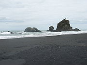
Beach
A beach is a geological landform along the shoreline of an ocean, sea, lake or river. It usually consists of loose particles which are often composed of rock, such as sand, gravel, shingle, pebbles or cobblestones...
on the west coast of the Auckland Region
Auckland Region
The Auckland Region was one of the sixteen regions of New Zealand, named for the city of Auckland, the country's largest urban area. With one third of the nation's residents, it was by far the biggest population and economy of any region of New Zealand, but the second-smallest land area.On 1...
in the North Island
North Island
The North Island is one of the two main islands of New Zealand, separated from the much less populous South Island by Cook Strait. The island is in area, making it the world's 14th-largest island...
of New Zealand
New Zealand
New Zealand is an island country in the south-western Pacific Ocean comprising two main landmasses and numerous smaller islands. The country is situated some east of Australia across the Tasman Sea, and roughly south of the Pacific island nations of New Caledonia, Fiji, and Tonga...
.
Access, Location
The road to it is unsealed, and beach access is poorly signposted from the end of the road.To the south of Whatipu is Manukau Harbour
Manukau Harbour
Manukau Harbour is the second largest natural harbour in New Zealand by area. It is located to the southwest of the Auckland isthmus, and is an arm of the Tasman Sea.-Geography:...
. To the north is Karekare
Karekare, New Zealand
Karekare is a small coastal settlement in northern New Zealand, where the Waitakere Ranges descend into a large black sand surf beach.- Location :It is located 35 kilometres west of Auckland city centre, south of the larger beach of Piha....
.
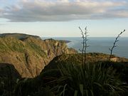
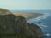
Whatipu is located at the southern end of the Waitakere Ranges.
Surfing
Whatipu has no surf patrol, and as with all the beaches west of Auckland, swimming may not be safe due to ripsRip current
A rip current, commonly referred to by the misnomer rip tide, is a strong channel of water flowing seaward from near the shore, typically through the surf line. Typical flow is at 0.5 metres per second , and can be as fast as 2.5 metres per second...
.
Caves
There are spectacular caves about 20 minutes walk from the carpark, but there is no access from the caves to the beach. In pre-European times, the caves were used as shelter by travellers. In the early 20th century, the largest cave was used for dances, but sand has since drifted into the cave and the dance floor is now covered by five metres of sand.Shipwreck
HMS OrpheusHMS Orpheus (1861)
HMS Orpheus was a Jason-class Royal Navy corvette that served as the flagship of the Australian squadron. Orpheus sank off the west coast of Auckland, New Zealand on 7 February 1863: 189 crew out of the ship's complement of 259 died in the disaster, making it the worst maritime tragedy to occur in...
ran aground just inside the Manukau Harbour entrance south of Whatipu in 1863 with the loss of 189 lives.
Historic Industry
There was a timber mill built at Whatipu in 1867 to service the kauri trade. A tramline was built to a second timber mill three kilometers north in 1870, and eventually extended up to PihaPiha
Piha is a northern New Zealand coastal settlement with a population of about 600. It is one of the most popular beaches in the area and a major day-trip destination for Aucklanders throughout the year, although especially so in summer.-Location:...
and Anawhata
Anawhata
Anawhata is a beach on the coast of New Zealand west of Auckland.-Location:Distance from Auckland; 40km . To the south of Anawhata is Piha, Karekare and Whatipu...
. The mills closed in 1886 when the kauri ran out.