

Welland Canal, bridge 13
Encyclopedia
The Welland Canal - bridge 13, or as more commonly known locally, the Welland Main Street bridge is a vertical lift bridge located in the heart of downtown Welland, Ontario
. The bridge crosses an abandoned portion of the Welland Canal
known as the Welland Recreational Waterway
.
 The channel passing under this bridge is the fourth Welland Canal. A bridge has existed at this location ever since the first canal was constructed. The bridge is the location of a major historical intersection in the original roads of the Niagara Peninsula
. As well as being important to local traffic in Welland, the bridge also links East Main Street (leading towards Niagara Falls
) and West Main Street (providing access to roads leading along the Welland River
to Wainfleet
and Wellandport. It also provides a link between Niagara Street (formerly known as North Main Street leading to Thorold
and St. Catharines
, and King Street (formerly South Main Street, and also Canal Street), formerly leading to the Canada Southern Railway
station, and on to Port Colborne
.
The Chippawa Road (as Main Street was then known) crossed the First Welland Canal
(constructed between 1824 and 1829) via a wooden swing bridge with the pivot set to one side of the canal. This was turned manually by pushing on heavy wooden beams extending from the end of the bridge .
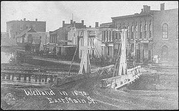
The bridge over the Second Welland Canal (constructed 1840 to 1845) is recorded in at least one image (shown at left), which has been seen in several books, in the Welland Library and on a post card. This was a swing bridge of a design common to other locations on the second canal . It can be seen from the picture that the pivot was to the west of the canal. These bridges were painted white and operated manually.
The Third Welland Canal was constructed between 1871 and 1881 and located slightly west of the second. The bridge over this canal was constructed one block south of Main Street at Division Street. This situation severed the primary commercial artery and caused hardship for local business. In winter when the canal was closed, a floating plank bridge, just 1.2m (4 feet) wide allowed pedestrian access across the canal at Main Street, but significant pressure was placed on officials to build a permanent bridge at this location. Eventually, a bridge known as the Alexandra Bridge was built at Main Street in 1903. This Bridge is well documented at the Welland Public Library Local History Site. In 1927, this bridge was moved one block south to Division Street to make room for construction of the current Bridge 13.
, and this massive project was not completed until 1932.
Bridge 13 was constructed between 1927 and 1930, with steel work of the span being constructed on temporary pilings driven into the canal bed during the winter of 1929-30 (while the shipping season was closed). The bridge was built by the Dominion Bridge Company, with most of the steel work being completed by members of the Mohawk First Nation
, who have a long history of being some of the finest ironworkers in North America.
The bridge was the most expensive on the canal, with a construction cost of $986,363. The bridge is 9.1 metres (29.9 ft) wide - significantly wider than most canal bridges. It was designed to carry a streetcar track down the middle, but the Welland streetcar system (the Niagara, Welland and Lake Erie railway
) was slated for abandonment before the bridge was actually opened and this track was never installed.
The bridge is 70.6 metres (231.6 ft) long and has a skew of approximately 22.5 degrees - meaning that the towers and span are off square by this amount. The reason that the skew is required can be seen from the old picture of the second canal bridge above - the canal does not run at a 90 degree angle to Main Street. While a bridge out of alignment with the road was acceptable in the 1840s, a straight road was considered essential in the 1920s. No other canal bridge is skewed to this degree.
The bridge is located on a curve in a congested area of the canal. This led to several incidents over the years. Ships failing to negotiate the curve, on at least a couple of occasions, collided with the western approach span. The Welland Public Library holds a file of newspaper clippings regarding such collisions, including one where the ship Atomena collided with the bridge in 1970.
) made the route difficult and dangerous.
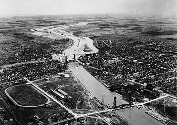
In 1967, it was decided to re-route the canal to the east of the city via the Welland By-Pass
. Construction proceeded through the 1972 shipping season, and by the end of that season, work was close to completion. In the late evening hours of December 15, 1972, the Main Street Bridge raised to allow the passage of the Georgian Bay - officially the last ship through the city of Welland. In fact, the bridge was raised again the next day to allow a St. Lawrence Seaway service vessel to pass, but the Georgian Bay remains the official last passage under the bridge in most historical records.
 Following the closure of the canal at the end of the 1972 shipping season, Bridge 13 was locked permanently in the lowered position. The stairs leading to the control cabin were removed to prevent trespassing and vehicular traffic continued to cross the bridge, without interruption from passing ships.
In 1981, a parallel bridge was built at Division Street, and the Main Street bridge became a one-way road carrying west-bound traffic only. The original three lanes were reduced to two wider lanes of traffic.
The concrete counterweights continued to hang over the road, and as time went on, they began to decay and drop chunks of concrete on the road below. Initially, they were encased in plywood boxes, but eventually, it was deemed necessary to remove them. In 1983, the bridge was closed to traffic and a contractor was brought in to lower, then break up the counterweights. The closure caused significant traffic issues, and after a period of time, the City of Welland decided to temporarily change the adjacent Division Street Bridge to two way traffic
In 2006, the bridge was once again closed to traffic for several months to allow for major re-construction of the structural elements. This was part of a three year overhaul program on the bridge which was completed in late 2008.
Welland is making a concerted effort to revitalize the downtown area. The new Civic Square is just a block to the east of the bridge, and an observation platform built beside the canal offers views of the bridge. Nevertheless, business has not flocked back to the downtown area. With the closure of many Welland industries and the resultant increase in numbers of persons in need, the downtown area has become home to organizations such as Goodwill
and similar service groups, as opposed to significant private enterprise.
Recommendations for development of the bridge include installing elevators to provide access to the top of the towers as a lookout. Whatever historical significance the bridge has, it remains primarily a utilitarian transportation corridor linking major east, west, north and south corridors in the city.
Welland, Ontario
Welland is a city in the Regional Municipality of Niagara in Southern Ontario, Canada.The city has been traditionally known as the place where rails and water meet, referring to the railways from Buffalo to Toronto and Southwestern Ontario, and the waterways of Welland Canal and Welland River,...
. The bridge crosses an abandoned portion of the Welland Canal
Welland Canal
The Welland Canal is a ship canal in Canada that extends from Port Weller, Ontario, on Lake Ontario, to Port Colborne, Ontario, on Lake Erie. As a part of the St...
known as the Welland Recreational Waterway
Welland Recreational Waterway
The Welland Recreational Waterway is a water channel in the city of Welland, Ontario, Canada. It is an old alignment of the Welland Ship Canal that has been abandoned after the construction of the Welland By-Pass in the 1970s. The Waterway is now managed by the Welland Recreational Canal...
.
Previous bridges at this site
Niagara Peninsula
The Niagara Peninsula is the portion of Southern Ontario, Canada lying between the south shore of Lake Ontario and the north shore of Lake Erie. It stretches from the Niagara River in the east to Hamilton, Ontario in the west. The population of the peninsula is roughly 1,000,000 people...
. As well as being important to local traffic in Welland, the bridge also links East Main Street (leading towards Niagara Falls
Niagara Falls, Ontario
Niagara Falls is a Canadian city on the Niagara River in the Golden Horseshoe region of Southern Ontario. The municipality was incorporated on June 12, 1903...
) and West Main Street (providing access to roads leading along the Welland River
Welland River
The Welland River is a river in the Niagara Region of southern Ontario which flows from its headwaters south of Hamilton, Ontario to empty into the Niagara River near the city of Niagara Falls, Ontario. It drains an area of 880 km²....
to Wainfleet
Wainfleet, Ontario
Wainfleet is a rural township in southern Niagara Region, Ontario, Canada.There is a small and growing tourist industry, near and on Lake Erie at the southern area of Wainfleet called Long Beach...
and Wellandport. It also provides a link between Niagara Street (formerly known as North Main Street leading to Thorold
Thorold, Ontario
Thorold is a city in Ontario, Canada, located on the Niagara Escarpment. It is also the seat of the Regional Municipality of Niagara....
and St. Catharines
St. Catharines, Ontario
St. Catharines is the largest city in Canada's Niagara Region and the sixth largest urban area in Ontario, Canada, with 97.11 square kilometres of land...
, and King Street (formerly South Main Street, and also Canal Street), formerly leading to the Canada Southern Railway
Canada Southern Railway
The Canada Southern Railway was a railway in southern Ontario, Canada, founded on February 28, 1868 as the Erie and Niagara Extension Railway. It adopted the Canada Southern Railway name on December 24, 1869. In 1904 the railway was leased to the Michigan Central Railroad for 99 years; in 1929 it...
station, and on to Port Colborne
Port Colborne, Ontario
Port Colborne is a city on Lake Erie, at the southern end of the Welland Canal, in the Niagara Region of southern Ontario, Canada...
.
The Chippawa Road (as Main Street was then known) crossed the First Welland Canal
First Welland Canal
The Welland Canal has gone through many incarnations in its history. Today, five distinct canal-construction efforts are recognized. The retronym First Welland Canal is applied to the original canal, constructed from 1824 to 1829 and 1831 to 1833....
(constructed between 1824 and 1829) via a wooden swing bridge with the pivot set to one side of the canal. This was turned manually by pushing on heavy wooden beams extending from the end of the bridge .
The bridge over the Second Welland Canal (constructed 1840 to 1845) is recorded in at least one image (shown at left), which has been seen in several books, in the Welland Library and on a post card. This was a swing bridge of a design common to other locations on the second canal . It can be seen from the picture that the pivot was to the west of the canal. These bridges were painted white and operated manually.
The Third Welland Canal was constructed between 1871 and 1881 and located slightly west of the second. The bridge over this canal was constructed one block south of Main Street at Division Street. This situation severed the primary commercial artery and caused hardship for local business. In winter when the canal was closed, a floating plank bridge, just 1.2m (4 feet) wide allowed pedestrian access across the canal at Main Street, but significant pressure was placed on officials to build a permanent bridge at this location. Eventually, a bridge known as the Alexandra Bridge was built at Main Street in 1903. This Bridge is well documented at the Welland Public Library Local History Site. In 1927, this bridge was moved one block south to Division Street to make room for construction of the current Bridge 13.
Construction
While the previous three canals were each at slightly different locations, the width of the greatly expanded fourth canal encompassed all of them. Fourth canal construction started as early as 1913. There were delays as a result of World War IWorld War I
World War I , which was predominantly called the World War or the Great War from its occurrence until 1939, and the First World War or World War I thereafter, was a major war centred in Europe that began on 28 July 1914 and lasted until 11 November 1918...
, and this massive project was not completed until 1932.
Bridge 13 was constructed between 1927 and 1930, with steel work of the span being constructed on temporary pilings driven into the canal bed during the winter of 1929-30 (while the shipping season was closed). The bridge was built by the Dominion Bridge Company, with most of the steel work being completed by members of the Mohawk First Nation
Mohawk nation
Mohawk are the most easterly tribe of the Iroquois confederation. They call themselves Kanien'gehaga, people of the place of the flint...
, who have a long history of being some of the finest ironworkers in North America.
The bridge was the most expensive on the canal, with a construction cost of $986,363. The bridge is 9.1 metres (29.9 ft) wide - significantly wider than most canal bridges. It was designed to carry a streetcar track down the middle, but the Welland streetcar system (the Niagara, Welland and Lake Erie railway
Niagara, Welland and Lake Erie railway
The Niagara, Welland and Lake Erie Railway operated a streetcar service in Welland, Ontario from 1912 until 1930.On July 4, 1910, the Niagara, Welland and Lake Erie Railway Company was granted a 20 year franchise to operate a street railway in the Town of Welland...
) was slated for abandonment before the bridge was actually opened and this track was never installed.
The bridge is 70.6 metres (231.6 ft) long and has a skew of approximately 22.5 degrees - meaning that the towers and span are off square by this amount. The reason that the skew is required can be seen from the old picture of the second canal bridge above - the canal does not run at a 90 degree angle to Main Street. While a bridge out of alignment with the road was acceptable in the 1840s, a straight road was considered essential in the 1920s. No other canal bridge is skewed to this degree.
Operation and incidents
During its operational life, the bridge carried three lanes of traffic - two west bound (the middle lane being designated as through traffic to West Main Street and the right for a turn onto Niagara Street), and one east bound lane, which was required to turn right onto King Street as East Main street has been one-way west bound since at least the mid 1950s.The bridge is located on a curve in a congested area of the canal. This led to several incidents over the years. Ships failing to negotiate the curve, on at least a couple of occasions, collided with the western approach span. The Welland Public Library holds a file of newspaper clippings regarding such collisions, including one where the ship Atomena collided with the bridge in 1970.
The last ship
The route through Welland which had crossed Main Street since the 1830s was winding and difficult. The large number of bridges, and especially a railroad swing bridge (Welland Canal, Bridge 15Welland Canal, Bridge 15
The Welland Canal Bridge 15 is a two-track Baltimore truss swing bridge located in the disused section of the Welland Canal within the city of Welland, Ontario. This section of canal is now known as the Welland Recreational Waterway...
) made the route difficult and dangerous.
In 1967, it was decided to re-route the canal to the east of the city via the Welland By-Pass
Welland By-Pass
The Welland By-pass, completed in 1973, was a massive construction project on the Welland Canal in Ontario, Canada.A new channel long was constructed, providing a shorter, more direct alignment between Port Robinson and Port Colborne and by-passing downtown Welland...
. Construction proceeded through the 1972 shipping season, and by the end of that season, work was close to completion. In the late evening hours of December 15, 1972, the Main Street Bridge raised to allow the passage of the Georgian Bay - officially the last ship through the city of Welland. In fact, the bridge was raised again the next day to allow a St. Lawrence Seaway service vessel to pass, but the Georgian Bay remains the official last passage under the bridge in most historical records.
After the last ship
In 1981, a parallel bridge was built at Division Street, and the Main Street bridge became a one-way road carrying west-bound traffic only. The original three lanes were reduced to two wider lanes of traffic.
The concrete counterweights continued to hang over the road, and as time went on, they began to decay and drop chunks of concrete on the road below. Initially, they were encased in plywood boxes, but eventually, it was deemed necessary to remove them. In 1983, the bridge was closed to traffic and a contractor was brought in to lower, then break up the counterweights. The closure caused significant traffic issues, and after a period of time, the City of Welland decided to temporarily change the adjacent Division Street Bridge to two way traffic
In 2006, the bridge was once again closed to traffic for several months to allow for major re-construction of the structural elements. This was part of a three year overhaul program on the bridge which was completed in late 2008.
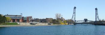
The bridge today, and the neighbourhood around it
The bridge has become the symbol of the City of Welland. Even though the bridge towers no longer serve any practical purpose, their preservation has been given a priority owing to their historical significance.Welland is making a concerted effort to revitalize the downtown area. The new Civic Square is just a block to the east of the bridge, and an observation platform built beside the canal offers views of the bridge. Nevertheless, business has not flocked back to the downtown area. With the closure of many Welland industries and the resultant increase in numbers of persons in need, the downtown area has become home to organizations such as Goodwill
Goodwill Industries
Goodwill Industries International is a not-for-profit organization that provides job training, employment placement services and other community-based programs for people who have a disability, lack education or job experience, or face employment challenges...
and similar service groups, as opposed to significant private enterprise.
Recommendations for development of the bridge include installing elevators to provide access to the top of the towers as a lookout. Whatever historical significance the bridge has, it remains primarily a utilitarian transportation corridor linking major east, west, north and south corridors in the city.