
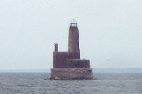
Waugoshance Light
Encyclopedia
The lighthouse at Waugoshance protects boats from a shoal
area at the northern end of Lake Michigan
. The lighthouse is located in Emmet County, Michigan
, United States, and in U.S. Coast Guard District No. 9.
is not only shallow, it's a large (in area) projection from the bottom of the lake. Boats large enough to safely travel in times of storm cannot approach the light closer than a few hundred yards.
Adding to the complication of navigation in this area is the White Shoal, located just north of Waugoshance. This area is currently protected by White Shoal Light
—built in 1912, nearby, powerful and larger—and Grays Reef Light which rendered this lighthouse obsolete.
During the last half of the nineteenth century, this light marked the turning point for ships traveling through the Straits of Mackinac
and along Lake Michigan
's eastern shore between the mainland and the Beavers. With a water less than 12 feet (3.7 m) deep, it was "one of the most dangerous parts of the Straits." Thereafter, a "Gray's Reef passage" became more typical because modern freighters
require considerably more depth, so Waugoshance is bypassed about 2 miles (3.2 km) to the west.
on the Great Lakes
was placed here. That wooden lightship was the Lois McLain. In 1851 she was replaced by the Waugoshance Light, which stands in the area of the Wilderness State Park
, and which remains one of the most hazardous areas near the Straits of Mackinac
, Michigan
. The last lightvessel on the Great Lakes was the Lightship Huron.
The lighthouse at Waugoshance was arguably the first light built in the Great Lakes that was totally surrounded by water. Both its construction and its continued maintenance were rendered extremely hazardous by the severe weather conditions of the area. Waugoshance is at the northern end of the long fetch of "south-wester" waves on Lake Michigan; the wave action is amplified as they build upon the shoal.
The imposing crib structure was a first on the Great Lakes. The pier was reconstructed in 1870—a massive undertaking that was hampered by the ironic fact that the viable 'building season' is far shorter than even the normal operating season for the light—and used a "bird cage" lantern, which makes it one of only three built on the Great Lakes. The lantern originally held the first fourth order Fresnel lens on the Great Lakes.
Although the light is now gray in color, it was originally painted in four broad horizontal Red and white stripes as a Daymark
. Its walls were encased in steel, and are 5½ feet thick at the bottom. The Waugoshance Light operated from 1851 until its deactivation in 1912, when it remained the property of the U.S. federal government. The encasement was similar to Big Sable Point Light
, which was made from Cream City Brick
, and also had to be encased in steel
boiler
plate to retard the deterioration.
Of particular note were the efforts of Lighthouse keeper
s who rang bells for many days, trying to ward mariners and their vessels off the shoal as they groped through the smoke from the many fires — 1871 Great Chicago Fire, Peshtigo Fire
, Northern Michigan
including large tracts around Manistee, Michigan
, Western Michigan
around Holland
and the fire in the Thumb
near Port Huron
-- that took place beginning October 8, 1871, casting an impenetrable pall across Lake Michigan for the better part of a week. However, many vessels were lost.
During World War II, the abandoned light was used by the U.S. Navy for bombing practice. The Lighthouse keeper
's house and all of the wood framing in the lighthouse burnt. The metal shell has fallen away. Today, the lighthouse "is considered one of the most endangered lighthouses in the world." It has been said that, ". . . . it is amazing that anything remains."
It is said to be both a "nautical gravestone" (because of the many wrecks in the vicinity) and on the "most endangered list" of lighthouses, being on the Lighthouse Digest
"Doomsday List
." It is one of six in Michigan; the remaining five are: Charity Island Light, Fourteen Mile Point Light, Gull Rock Light, Manitou Island Light and Poverty Island Light
.
The Waugoshance Lighthouse Preservation Society was formed in 2000. It has undertaken preservation and restoration. The Society's "first priority is raising funds to stabilize the building." It is soliciting funds to rebuild the light, and is seeking an extended lease from the U.S. Coast Guard, so that restoration can continue. In 2009, under the terms of the National Historic Lighthouse Preservation Act
the lighthouse was put up for public sale. Another source reports, however, that "In 2009, [it was] deemed excess by the U.S. Coast Guard," so it was "offered at no cost to eligible entities, including federal, state, and local agencies, non-profit corporations, and educational organizations under the provisions of the National Historic Lighthouse Preservation Act of 2000."
A private boat is recommended to see this light close up. These are, however, dangerous and open water over wide expanses far from shore and interlaced by shoals, so caution is advised.
Short of that, Shepler's Ferry Service out of Mackinaw City offers periodic lighthouse cruises in the summer season. Its "westbound Lighthouse Tour"—three hours more or less—includes passes by various lights, including Waugoshance Light, White Shoal Light
, Wilderness State Park
, Gray's Reef Light (originally built in 1891), and St. Helena Island Light. Schedules and rates are available from Shepler's.
Another alternative is to charter a seaplane
to make a tour of the Mackinac Straits and environs.
Shoal
Shoal, shoals or shoaling may mean:* Shoal, a sandbank or reef creating shallow water, especially where it forms a hazard to shipping* Shoal draught , of a boat with shallow draught which can pass over some shoals: see Draft...
area at the northern end of Lake Michigan
Lake Michigan
Lake Michigan is one of the five Great Lakes of North America and the only one located entirely within the United States. It is the second largest of the Great Lakes by volume and the third largest by surface area, after Lake Superior and Lake Huron...
. The lighthouse is located in Emmet County, Michigan
Emmet County, Michigan
Emmet County is a county in the U.S. state of Michigan. As of the 2000 census, the population was 31,437. The county seat is Petoskey.The county was formed April 1, 1840, from Mackinac County. It was first named Tonedagana County and renamed Emmet County on March 8, 1843...
, United States, and in U.S. Coast Guard District No. 9.
Reason for lighthouse
Boats from Chicago heading North (and ultimately) East need to navigate the narrow tip of northern Lake Michigan, and there are many dangers. The area around Waugoshance PointWaugoshance Point
Waugoshance Point is a headland that juts into Lake Michigan from the northwest coast of the Lower Peninsula of the U.S. state of Michigan. It lies entirely within Wilderness State Park in Emmet County. The nearest major town is Mackinaw City...
is not only shallow, it's a large (in area) projection from the bottom of the lake. Boats large enough to safely travel in times of storm cannot approach the light closer than a few hundred yards.
Adding to the complication of navigation in this area is the White Shoal, located just north of Waugoshance. This area is currently protected by White Shoal Light
White Shoal Light (Michigan)
The White Shoal Light is a lighthouse located 20 miles west of the Mackinac Bridge in Lake Michigan. It is an active aid to navigation.-Overview:...
—built in 1912, nearby, powerful and larger—and Grays Reef Light which rendered this lighthouse obsolete.
During the last half of the nineteenth century, this light marked the turning point for ships traveling through the Straits of Mackinac
Straits of Mackinac
The Straits of Mackinac is the strip of water that connects two of the Great Lakes, Lake Michigan and Lake Huron, and separates the Lower Peninsula of Michigan from the Upper Peninsula of Michigan. It is a shipping lane providing passage for raw materials and finished goods, connecting, for...
and along Lake Michigan
Lake Michigan
Lake Michigan is one of the five Great Lakes of North America and the only one located entirely within the United States. It is the second largest of the Great Lakes by volume and the third largest by surface area, after Lake Superior and Lake Huron...
's eastern shore between the mainland and the Beavers. With a water less than 12 feet (3.7 m) deep, it was "one of the most dangerous parts of the Straits." Thereafter, a "Gray's Reef passage" became more typical because modern freighters
Cargo ship
A cargo ship or freighter is any sort of ship or vessel that carries cargo, goods, and materials from one port to another. Thousands of cargo carriers ply the world's seas and oceans each year; they handle the bulk of international trade...
require considerably more depth, so Waugoshance is bypassed about 2 miles (3.2 km) to the west.
History
In 1832 the first lightvesselLightvessel
A lightvessel, or lightship, is a ship which acts as a lighthouse. They are used in waters that are too deep or otherwise unsuitable for lighthouse construction...
on the Great Lakes
Great Lakes
The Great Lakes are a collection of freshwater lakes located in northeastern North America, on the Canada – United States border. Consisting of Lakes Superior, Michigan, Huron, Erie, and Ontario, they form the largest group of freshwater lakes on Earth by total surface, coming in second by volume...
was placed here. That wooden lightship was the Lois McLain. In 1851 she was replaced by the Waugoshance Light, which stands in the area of the Wilderness State Park
Wilderness State Park
Wilderness State Park is an state park in the U.S. state of Michigan. It is located in Emmet County in Northern Michigan. The nearest towns are Carp Lake, Michigan and Mackinaw City, Michigan. The state park is operated by the Michigan Department of Natural Resources...
, and which remains one of the most hazardous areas near the Straits of Mackinac
Straits of Mackinac
The Straits of Mackinac is the strip of water that connects two of the Great Lakes, Lake Michigan and Lake Huron, and separates the Lower Peninsula of Michigan from the Upper Peninsula of Michigan. It is a shipping lane providing passage for raw materials and finished goods, connecting, for...
, Michigan
Michigan
Michigan is a U.S. state located in the Great Lakes Region of the United States of America. The name Michigan is the French form of the Ojibwa word mishigamaa, meaning "large water" or "large lake"....
. The last lightvessel on the Great Lakes was the Lightship Huron.
The lighthouse at Waugoshance was arguably the first light built in the Great Lakes that was totally surrounded by water. Both its construction and its continued maintenance were rendered extremely hazardous by the severe weather conditions of the area. Waugoshance is at the northern end of the long fetch of "south-wester" waves on Lake Michigan; the wave action is amplified as they build upon the shoal.
The imposing crib structure was a first on the Great Lakes. The pier was reconstructed in 1870—a massive undertaking that was hampered by the ironic fact that the viable 'building season' is far shorter than even the normal operating season for the light—and used a "bird cage" lantern, which makes it one of only three built on the Great Lakes. The lantern originally held the first fourth order Fresnel lens on the Great Lakes.
Although the light is now gray in color, it was originally painted in four broad horizontal Red and white stripes as a Daymark
Daymark
A daymark or a day marker is a structure such as a tower constructed on land as an aid to navigation by sailors. While similar in concept to a lighthouse, a daymark does not have a light and so is usually only visible during daylight hours...
. Its walls were encased in steel, and are 5½ feet thick at the bottom. The Waugoshance Light operated from 1851 until its deactivation in 1912, when it remained the property of the U.S. federal government. The encasement was similar to Big Sable Point Light
Big Sable Point Light
The Big Sable Point Light is a lighthouse on the eastern shore of Lake Michigan near Ludington in Mason County, Michigan, at the Ludington State Park. It is an active aid to navigation.-History:...
, which was made from Cream City Brick
Cream City brick
Cream City brick is a cream or light yellow-colored brick made from a clay found around Milwaukee, Wisconsin, in the Menomonee River Valley and on the western banks of Lake Michigan...
, and also had to be encased in steel
Steel
Steel is an alloy that consists mostly of iron and has a carbon content between 0.2% and 2.1% by weight, depending on the grade. Carbon is the most common alloying material for iron, but various other alloying elements are used, such as manganese, chromium, vanadium, and tungsten...
boiler
Boiler
A boiler is a closed vessel in which water or other fluid is heated. The heated or vaporized fluid exits the boiler for use in various processes or heating applications.-Materials:...
plate to retard the deterioration.
Of particular note were the efforts of Lighthouse keeper
Lighthouse keeper
A lighthouse keeper is the person responsible for tending and caring for a lighthouse, particularly the light and lens in the days when oil lamps and clockwork mechanisms were used. Keepers were needed to trim the wicks, replenish fuel, wind clockworks and perform maintenance tasks such as cleaning...
s who rang bells for many days, trying to ward mariners and their vessels off the shoal as they groped through the smoke from the many fires — 1871 Great Chicago Fire, Peshtigo Fire
Peshtigo Fire
The October 8, 1871 Peshtigo Fire in Peshtigo, Wisconsin, is the conflagration that caused the most deaths by fire in United States history, killing as many as 1,500. Occurring on the same day as the more infamous Great Chicago Fire, the Peshtigo Fire is mostly forgotten...
, Northern Michigan
Northern Michigan
Northern Michigan, also known as Northern Lower Michigan , is a region of the U.S. state of Michigan...
including large tracts around Manistee, Michigan
Manistee, Michigan
Manistee is a city in the U.S. state of Michigan. As of the 2000 census, the city population was 6,586. It is the county seat of Manistee County. The name "Manistee" is from an Ojibwe word first applied to the principal river of the county. The derivation is not certain, but it may be from...
, Western Michigan
Western Michigan
West Michigan and Western Michigan are terms for an arbitrarily selected region in the U.S. state of Michigan in its Lower Peninsula. There is no official definition for what constitutes "West Michigan." The area of West Michigan may also include parts Southern Michigan.-Definition:In general,...
around Holland
Holland, Michigan
Holland is a city in the western region of the Lower Peninsula of the U.S. state of Michigan. It is situated near the eastern shore of Lake Michigan on Lake Macatawa, which is fed by the Macatawa River ....
and the fire in the Thumb
The Thumb
The Thumb is a region and a peninsula of Michigan, so named because the Lower Peninsula is shaped like a mitten; thus the Thumb is the area that looks like the thumb of the mitten. The Thumb is generally considered to be in the Mid-Michigan area of the state, located east of Flint/Tri-Cities...
near Port Huron
Port Huron, Michigan
Port Huron is a city in the U.S. state of Michigan and the county seat of St. Clair County. The population was 30,184 at the 2010 census. The city is adjacent to Port Huron Township but is administratively autonomous. It is joined by the Blue Water Bridge over the St. Clair River to Sarnia,...
-- that took place beginning October 8, 1871, casting an impenetrable pall across Lake Michigan for the better part of a week. However, many vessels were lost.
During World War II, the abandoned light was used by the U.S. Navy for bombing practice. The Lighthouse keeper
Lighthouse keeper
A lighthouse keeper is the person responsible for tending and caring for a lighthouse, particularly the light and lens in the days when oil lamps and clockwork mechanisms were used. Keepers were needed to trim the wicks, replenish fuel, wind clockworks and perform maintenance tasks such as cleaning...
's house and all of the wood framing in the lighthouse burnt. The metal shell has fallen away. Today, the lighthouse "is considered one of the most endangered lighthouses in the world." It has been said that, ". . . . it is amazing that anything remains."
Current status
The light is listed on the National Register, Reference #83000841, Name of Listing: WAUGOSHANCE LIGHT STATION (U.S. COAST GUARD/GREAT LAKES TR) It is not on the state list inventory.It is said to be both a "nautical gravestone" (because of the many wrecks in the vicinity) and on the "most endangered list" of lighthouses, being on the Lighthouse Digest
Lighthouse Digest
Lighthouse Digest is a specialty magazine for lighthouse and maritime history enthusiasts published in East Machias, Maine. Launched in May, 1992, by FogHorn Publishing, it is dedicated to preserving lighthouse history, current and yesteryear, for future generations.-Scope:Coverage includes...
"Doomsday List
Doomsday List
The Doomsday List is a list of endangered lighthouses compiled by Lighthouse Digest magazine. The list usually consists of lighthouses in the United States, Guatemala, and Canada, but occasionally will include sites from other countries as well. Inclusion on the list raises awareness that a...
." It is one of six in Michigan; the remaining five are: Charity Island Light, Fourteen Mile Point Light, Gull Rock Light, Manitou Island Light and Poverty Island Light
Poverty Island
Poverty Island is a small island in the U.S. state of Michigan. The island is within Delta County in Lake Michigan and is home to an abandoned lighthouse which is in disrepair. Poverty Island is currently owned by the federal government....
.
The Waugoshance Lighthouse Preservation Society was formed in 2000. It has undertaken preservation and restoration. The Society's "first priority is raising funds to stabilize the building." It is soliciting funds to rebuild the light, and is seeking an extended lease from the U.S. Coast Guard, so that restoration can continue. In 2009, under the terms of the National Historic Lighthouse Preservation Act
National Historic Lighthouse Preservation Act
The National Historic Lighthouse Preservation Act of 2000 is American legislation creating a process for the transfer of federally-owned lighthouses into private hands...
the lighthouse was put up for public sale. Another source reports, however, that "In 2009, [it was] deemed excess by the U.S. Coast Guard," so it was "offered at no cost to eligible entities, including federal, state, and local agencies, non-profit corporations, and educational organizations under the provisions of the National Historic Lighthouse Preservation Act of 2000."
Getting there
The lighthouse is closed to the public.A private boat is recommended to see this light close up. These are, however, dangerous and open water over wide expanses far from shore and interlaced by shoals, so caution is advised.
Short of that, Shepler's Ferry Service out of Mackinaw City offers periodic lighthouse cruises in the summer season. Its "westbound Lighthouse Tour"—three hours more or less—includes passes by various lights, including Waugoshance Light, White Shoal Light
White Shoal Light (Michigan)
The White Shoal Light is a lighthouse located 20 miles west of the Mackinac Bridge in Lake Michigan. It is an active aid to navigation.-Overview:...
, Wilderness State Park
Wilderness State Park
Wilderness State Park is an state park in the U.S. state of Michigan. It is located in Emmet County in Northern Michigan. The nearest towns are Carp Lake, Michigan and Mackinaw City, Michigan. The state park is operated by the Michigan Department of Natural Resources...
, Gray's Reef Light (originally built in 1891), and St. Helena Island Light. Schedules and rates are available from Shepler's.
Another alternative is to charter a seaplane
Seaplane
A seaplane is a fixed-wing aircraft capable of taking off and landing on water. Seaplanes that can also take off and land on airfields are a subclass called amphibian aircraft...
to make a tour of the Mackinac Straits and environs.
Specialized further reading
- "A Tour of the Lights of the Straits." Michigan History 70 (Sep/Oct 1986), pp. 17–29.
External links
- Aerial photos, Waugoshance Light, marinas.com.
- Interactive map of Lights in Northern Lake Michigan, Google mapsGoogle MapsGoogle Maps is a web mapping service application and technology provided by Google, free , that powers many map-based services, including the Google Maps website, Google Ride Finder, Google Transit, and maps embedded on third-party websites via the Google Maps API...
. Waugoshance Shoal Light. - Waugoshance Lighthouse Preservation Society.