
Washington State Route 821
Encyclopedia
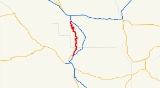
State Route 821, also known as Canyon Road, is a state highway
in Washington. It runs from an intersection with Interstate 82 north of Selah
to another junction with I-82 south of Ellensburg
. The total length of SR 821 is 25.2 miles (40.6 km).
through the Ellensburg Canyon. Behind Roza Dam
at the southern end is a reservoir that is used for boating through use of the boat ramp at the Bureau of Land Management
(BLM) Roza Access Area recreation site. The route through the canyon is scenic and mostly uninhabited. To the east in the area between 821 and I-82 are some ranches who have access roads off 821. Near the mid-point of the canyon is Riverview Campground, home of Red's Fly Shop which caters to the thriving tourist trade of recreationist that enjoy the canyon for floating, boating, fishing, etc. A footbridge further North provides access to the BLM managed Umtanum Recreation Area. At the north end of the canyon at Thrall Road, Canyon Road continues north, but SR 821 turns right on Thrall Road and runs 0.4 mile (0.643736 km) to another junction with I-82 at Exit 3, which is the northern terminus of SR 821. Route 821 can also be reached easily from I-90 via exit 109, the Canyon Road exit. From exit 109 to the Thrall Road intersection with SR 821 is a distance of 3.7 miles (6 km) along Canyon Road.
821 shares the canyon with the Yakima Sub Division of BNSF Railroad. 105 acre (0.4249203 km²) of the Canyon is a preserve owned by The Nature Conservancy
of Washington state.
, and was the only highway between Ellensburg and Yakima. In the 1970s I-82 was constructed east of the canyon over Manastash Ridge
, bypassing the old highway through Ellensburg Canyon. When I-82 was opened US 97 was rerouted to be concurrent with I-82 between Ellensburg and Yakima. The old section of US 97 through the canyon was renumbered as State Route 821.
State highway
State highway, state road or state route can refer to one of three related concepts, two of them related to a state or provincial government in a country that is divided into states or provinces :#A...
in Washington. It runs from an intersection with Interstate 82 north of Selah
Selah, Washington
Selah is a city in Yakima County, Washington, United States. The population was 7,147 at the 2010 census.-History:Selah was officially incorporated on April 3, 1919. The government is a Strong Mayor/Council form. The Tree Top apple processor co-operative has its headquarters and two processing...
to another junction with I-82 south of Ellensburg
Ellensburg, Washington
Ellensburg is a city in, and the county seat of, Kittitas County, Washington, United States. The population was 18,174 at the 2010 census. The population was 18,250 at 2011 Estimate from Office of Financial Management. Ellensburg is located just east of the Cascade Range on I-90 and is known as the...
. The total length of SR 821 is 25.2 miles (40.6 km).
Route description
State Route 821 begins at exit 26 on I-82 near Selah. Exit 26 is the Harrison Road/Firing Center Road exit. It then heads north along Canyon Road, passing the unincorporated community of Pomona and the substance abuse treatment center at the Sundown M Ranch. Also it bypasses abandoned short twin tunnel segments that the road once passed through, and continues by following the curves of the Yakima RiverYakima River
The Yakima River is a tributary of the Columbia River in south central and eastern Washington State, named for the indigenous Yakama people. The length of the river from headwaters to mouth is , with an average drop of .-Course:...
through the Ellensburg Canyon. Behind Roza Dam
Roza Dam
Roza Dam is a diversion dam on the Yakima River, about north of Yakima, just west of SR 821. The dam, built in 1939, is long at the crest and high, and impounds approximately of water. The dam also has 12,000 kW power production capacity, online as of 1956...
at the southern end is a reservoir that is used for boating through use of the boat ramp at the Bureau of Land Management
Bureau of Land Management
The Bureau of Land Management is an agency within the United States Department of the Interior which administers America's public lands, totaling approximately , or one-eighth of the landmass of the country. The BLM also manages of subsurface mineral estate underlying federal, state and private...
(BLM) Roza Access Area recreation site. The route through the canyon is scenic and mostly uninhabited. To the east in the area between 821 and I-82 are some ranches who have access roads off 821. Near the mid-point of the canyon is Riverview Campground, home of Red's Fly Shop which caters to the thriving tourist trade of recreationist that enjoy the canyon for floating, boating, fishing, etc. A footbridge further North provides access to the BLM managed Umtanum Recreation Area. At the north end of the canyon at Thrall Road, Canyon Road continues north, but SR 821 turns right on Thrall Road and runs 0.4 mile (0.643736 km) to another junction with I-82 at Exit 3, which is the northern terminus of SR 821. Route 821 can also be reached easily from I-90 via exit 109, the Canyon Road exit. From exit 109 to the Thrall Road intersection with SR 821 is a distance of 3.7 miles (6 km) along Canyon Road.
821 shares the canyon with the Yakima Sub Division of BNSF Railroad. 105 acre (0.4249203 km²) of the Canyon is a preserve owned by The Nature Conservancy
The Nature Conservancy
The Nature Conservancy is a US charitable environmental organization that works to preserve the plants, animals, and natural communities that represent the diversity of life on Earth by protecting the lands and waters they need to survive....
of Washington state.
History
State Route 821 was formerly a section of U.S. Route 97, the major north–south highway in Washington east of the CascadesCascade Range
The Cascade Range is a major mountain range of western North America, extending from southern British Columbia through Washington and Oregon to Northern California. It includes both non-volcanic mountains, such as the North Cascades, and the notable volcanoes known as the High Cascades...
, and was the only highway between Ellensburg and Yakima. In the 1970s I-82 was constructed east of the canyon over Manastash Ridge
Manastash Ridge
Manastash Ridge is a long anticline mountain ridge located in central Washington state in the United States. Manastash Ridge runs mostly west-to-east in Kittitas and Yakima counties, for approximately 50 miles...
, bypassing the old highway through Ellensburg Canyon. When I-82 was opened US 97 was rerouted to be concurrent with I-82 between Ellensburg and Yakima. The old section of US 97 through the canyon was renumbered as State Route 821.