
Wairau Valley
Encyclopedia
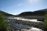
Wairau Valley is the valley of the Wairau River
in Marlborough, New Zealand
and also the name of the main settlement in the upper valley. State Highway 63 runs through the valley. The valley opens onto the Wairau Plain, where Renwick
and Blenheim
are sited. The Alpine
-Wairau Fault
runs along the length of the valley.
The population of the Wairau Valley and Wairau Plain, excluding Renwick and Blenheim, was 4,572 in the 2006 Census, an increase of 717 from 2001.
Wairauite is an iron-cobalt alloy which is named after the valley.
, led by Arthur Wakefield
, tried to take possession of the land but the Ngāti Toa
, led by Te Rauparaha
and Te Rangihaeata
objected. The dispute escalated into the Wairau Affray
at Tuamarina
on 23 June 1843, in which 22 settlers and four Māori and were killed. An enquiry held in 1844 by Governor Robert FitzRoy
decided that the settlers were in the wrong.
In 1847, Nelson farmers drove sheep into the Wairau valley and established settlements. Governor Sir George Grey
purchased the land in the same year, but legal title to the land for the settlers was sorted out later.
In the 1855 Wairarapa earthquake
, the eastern end of the Wairau valley subsided by over a metre.
of 5 and a roll of 66. A school first opened in the Wairau valley in 1861.
Wairau River
The Wairau River is one of the longest rivers in New Zealand's South Island. It flows for 170 kilometres from the Spenser Mountains , firstly in a northwards direction and then northeast down a long, straight valley in inland Marlborough.The river's lower reaches are noted for the surrounding...
in Marlborough, New Zealand
Marlborough, New Zealand
Marlborough is one of the regions of New Zealand, located in the northeast of the South Island. Marlborough is a unitary authority, both a region and a district, and its council is located at Blenheim. Marlborough is known for its dry climate, the picturesque Marlborough Sounds, and sauvignon blanc...
and also the name of the main settlement in the upper valley. State Highway 63 runs through the valley. The valley opens onto the Wairau Plain, where Renwick
Renwick, New Zealand
Renwick is a small town in Marlborough, New Zealand, close to the south bank of the Wairau River. It is located on State Highway 6, 12 km west of Blenheim. Havelock is 31 km north...
and Blenheim
Blenheim, New Zealand
Blenheim is the most populous town in the region of Marlborough, in the north east of the South Island of New Zealand, and the seat of the regional council. It has a population of The area which surrounds the town is well known as a centre of New Zealand's wine industry...
are sited. The Alpine
Alpine Fault
The Alpine Fault is a geological fault, more specifically known as a right-lateral strike-slip fault, that runs almost the entire length of New Zealand's South Island. It forms a transform boundary between the Pacific Plate and the Indo-Australian Plate. Earthquakes along the fault, and the...
-Wairau Fault
Wairau Fault
The Wairau Fault is an active dextral strike-slip fault in the northeastern part of South Island, New Zealand. It forms part of the Marlborough Fault System, which accommodates the transfer of displacement along the oblique convergent boundary between the Indo-Australian Plate and Pacific Plate,...
runs along the length of the valley.
The population of the Wairau Valley and Wairau Plain, excluding Renwick and Blenheim, was 4,572 in the 2006 Census, an increase of 717 from 2001.
Wairauite is an iron-cobalt alloy which is named after the valley.
History
J. S. Cotterell surveyed the Wairau Valley in November 1842, and reported it contained rich land. Settlers from NelsonNelson, New Zealand
Nelson is a city on the eastern shores of Tasman Bay, and is the economic and cultural centre of the Nelson-Tasman region. Established in 1841, it is the second oldest settled city in New Zealand and the oldest in the South Island....
, led by Arthur Wakefield
Arthur Wakefield
Captain Arthur Wakefield served with the Royal Navy, before joining his brother, Edward Gibbon Wakefield, in founding the new settlement at Nelson, New Zealand.-Royal Navy:...
, tried to take possession of the land but the Ngāti Toa
Ngati Toa
Ngāti Toa , an iwi , traces its descent from the eponymous ancestor Toarangatira. The Ngāti Toa region extends from Miria-te-kakara at Rangitikei to Wellington, and across Cook Strait to Wairau and Nelson....
, led by Te Rauparaha
Te Rauparaha
Te Rauparaha was a Māori rangatira and war leader of the Ngāti Toa tribe who took a leading part in the Musket Wars. He was influential in the original sale of conquered Rangitane land to the New Zealand Company and was a participant in the Wairau Incident in Marlborough...
and Te Rangihaeata
Te Rangihaeata
Te Rangihaeata , was a Ngāti Toa chief, nephew of Te Rauparaha. He had a leading part in the Wairau Affray and the Hutt Valley Campaign.-Early life:...
objected. The dispute escalated into the Wairau Affray
Wairau Affray
In New Zealand history, the Wairau Affray on 17 June 1843 was the first serious clash of arms between Māori and the British settlers after the signing of the Treaty of Waitangi, and the only one to take place in the South Island...
at Tuamarina
Tuamarina
Tuamarina is a locality in Marlborough, New Zealand. State Highway 1 runs through the area. The Tuamarina River joins the Wairau River just south of the settlement. Picton is about 18 km to the north, and Blenheim is about 10 km to the south.The name is a corruption of the Māori word Tuamarino,...
on 23 June 1843, in which 22 settlers and four Māori and were killed. An enquiry held in 1844 by Governor Robert FitzRoy
Robert FitzRoy
Vice-Admiral Robert FitzRoy RN achieved lasting fame as the captain of HMS Beagle during Charles Darwin's famous voyage, and as a pioneering meteorologist who made accurate weather forecasting a reality...
decided that the settlers were in the wrong.
In 1847, Nelson farmers drove sheep into the Wairau valley and established settlements. Governor Sir George Grey
George Grey
George Grey may refer to:*Sir George Grey, 2nd Baronet , British politician*George Grey, 2nd Earl of Kent *Sir George Grey , Governor of Cape Colony, South Australia and New Zealand...
purchased the land in the same year, but legal title to the land for the settlers was sorted out later.
In the 1855 Wairarapa earthquake
1855 Wairarapa earthquake
The 1855 Wairarapa earthquake occurred on 23 January at about 9 p.m. In Wellington, close to the epicenter, shaking lasted for at least 50 seconds. The magnitude of the earthquake is estimated to have been in the range 8.1-8.3, the most powerful recorded in New Zealand since systematic European...
, the eastern end of the Wairau valley subsided by over a metre.
Education
Wairau Valley School is a coeducational full primary (years 1-8) school with a decile ratingSocio-Economic Decile
Decile, Socio-Economic Decile or Socio-Economic Decile Band is a widely used measure in education in New Zealand used to target funding and support to more needy schools....
of 5 and a roll of 66. A school first opened in the Wairau valley in 1861.