

Waiariki
Encyclopedia
New Zealand
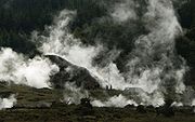
has a large number of hot springs
, known as waiariki in Māori
. Many of them are used for therapeutic purposes.
The highest concentration of such springs is in the Central Plateau region of the North Island
, in the Taupo Volcanic Zone
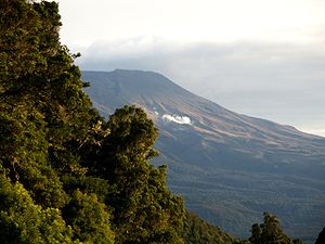
. The area of Whakarewarewa
near Rotorua
is also known as Waiariki due to the abundance of geothermal features in the area.
New Zealand
New Zealand is an island country in the south-western Pacific Ocean comprising two main landmasses and numerous smaller islands. The country is situated some east of Australia across the Tasman Sea, and roughly south of the Pacific island nations of New Caledonia, Fiji, and Tonga...
has a large number of hot springs
Hot Springs
Hot Springs may refer to:* Hot Springs, Arkansas** Hot Springs National Park, Arkansas*Hot Springs, California**Hot Springs, Lassen County, California**Hot Springs, Modoc County, California**Hot Springs, Placer County, California...
, known as waiariki in Māori
Maori language
Māori or te reo Māori , commonly te reo , is the language of the indigenous population of New Zealand, the Māori. It has the status of an official language in New Zealand...
. Many of them are used for therapeutic purposes.
The highest concentration of such springs is in the Central Plateau region of the North Island
North Island
The North Island is one of the two main islands of New Zealand, separated from the much less populous South Island by Cook Strait. The island is in area, making it the world's 14th-largest island...
, in the Taupo Volcanic Zone
Taupo Volcanic Zone
The Taupo Volcanic Zone is a highly active volcanic V shaped area in the North Island of New Zealand that is spreading east -west at the rate of about 8mm per year...
. The area of Whakarewarewa
Whakarewarewa
Whakarewarewa is a geothermal area within Rotorua city in the Taupo Volcanic Zone of New Zealand...
near Rotorua
Rotorua
Rotorua is a city on the southern shores of the lake of the same name, in the Bay of Plenty region of the North Island of New Zealand. The city is the seat of the Rotorua District, a territorial authority encompassing the city and several other nearby towns...
is also known as Waiariki due to the abundance of geothermal features in the area.
Hot springs of New Zealand
This is an incomplete list and does not include the less notable or popular locations.North Island
- Mount RuapehuMount RuapehuMount Ruapehu, or just Ruapehu, is an active stratovolcano at the southern end of the Taupo Volcanic Zone in New Zealand. It is 23 kilometres northeast of Ohakune and 40 kilometres southwest of the southern shore of Lake Taupo, within Tongariro National Park...
- Mount Ngaruahoe
- Ketetahi Springs
- Ngawha SpringsNgawha SpringsNgawha Springs is a small settlement approximately five kilometres east of the town of Kaikohe, Northland in New Zealand.It is the location of Ngawha Springs, a hot water spring that reputedly has therapeutic properties for those who bathe in its waters, and is the source of the steam used at the...
- ParakaiParakaiParakai is a township in the North Island of New Zealand. It is sited 43 kilometres northwest of Auckland, close to the southern extremity of the Kaipara Harbour...
, Helensville - WaiweraWaiweraWaiwera is a locality situated in the north of the Auckland Region in New Zealand. The name is of Māori origin and means "Hot Water" . Its main claim to fame are the hot water springs which were well-known in pre-European times and reputedly visited by Māori from as far away as Thames...
, near OrewaOrewaOrewa, a town in New Zealand's North Island lies on the Hibiscus Coast, just north of the base of the Whangaparaoa Peninsula and 40 kilometres north of central Auckland. Orewa's population was 7,326 in the 2006 Census, an increase of 1,692 from 2001. It is a popular holiday destination... - MirandaMiranda, New ZealandMiranda is a historical fort and small village in the Firth of Thames, New Zealand, which is now best known as the location of the Miranda Shorebird Centre, owned and operated by the Miranda Naturalists' Trust...
- Waingaro
- Kawhia
- Okoiroire
- MatamataMatamataMatamata is a rural Waikato town in New Zealand with a population of around 12,000 . It is located near the base of the Kaimai Ranges, and is a thriving farming area known for Thoroughbred horse breeding and training pursuits...
(Crystal Hot springs) - Te ArohaTe ArohaTe Aroha is a rural town in the Waikato region of New Zealand with a population of 3,768 . It is 53 km northeast of Hamilton and 50 km south of Thames. It sits at the foot of 952-metre Mount Te Aroha, the highest point in the Kaimai Range....
- PaeroaPaeroaPaeroa is a small town in New Zealand, in the northern Waikato region of the Thames Valley. Located at the foot of the Coromandel Peninsula, it is close to the junction of the Waihou and Ohinemuri Rivers, 20 kilometres from the coast at the Firth of Thames...
- KatikatiKatikatiKatikati is a town located on the Uretara Stream near the tidal inlet opened by Matakana Island in the Bay of Plenty, New Zealand. The nearest city is Tauranga, which is 40 kilometres to the southeast. Katikati lies 28 kilometres south of Waihi.Katikati was settled in 1875 by settlers from County...
- Morere Hot Springs Hawkes Bay
- TaupoTaupoTaupo is a town on the shore of Lake Taupo in the centre of the North Island of New Zealand. It is the seat of the Taupo District Council and lies in the southern Waikato Region....
(Craters of the Moon (geothermal site)Craters of the Moon (geothermal site)Craters of the Moon Thermal Area is a region with geothermal activity north of Taupo, New Zealand. It is a part of Wairakei, the largest geothermal field in New Zealand, with a surface area of about 25 km2, which lies in the Taupo Volcanic Zone.The name springs from the many hydrothermal eruption...
) (De Bretts) - Waihi VillageWaihi VillageWaihi Village, also known as Little Waihi, is a small Māori community of around 25 households. on the southwestern shores of Lake Taupo seven kilometres northwest of Turangi, New Zealand. It has been the site of three major landslides, in 1910, 1846 and around 1780, which killed over 200 people in...
, TokaanuTokaanuTokaanu is a small settlement close to Turangi at the southern end of Lake Taupo. The Tokaanu Thermal Pools and the easy access to Lake Taupo make it a popular lakeside holiday destination. A short walking track through the Tokaanu thermal area leads past steaming hot mineral pools and small mud...
, and Motuoapa near TurangiTurangiTurangi is a small town on the west bank of the Tongariro River, 50 kilometres south-west of Taupo on the North Island Volcanic Plateau of New Zealand. It was built to accommodate the workers associated with the Tongariro hydro-electric power development project and their families... - RotoruaRotoruaRotorua is a city on the southern shores of the lake of the same name, in the Bay of Plenty region of the North Island of New Zealand. The city is the seat of the Rotorua District, a territorial authority encompassing the city and several other nearby towns...
- TaurangaTaurangaTauranga is the most populous city in the Bay of Plenty region, in the North Island of New Zealand.It was settled by Europeans in the early 19th century and was constituted as a city in 1963...
- Mount MaunganuiMount MaunganuiMount Maunganui is a town in the Bay of Plenty, New Zealand, located on a peninsula to the north of Tauranga. It was independent from Tauranga until the completion of the Tauranga Harbour Bridge in 1988....
- WhakataneWhakataneWhakatane is a town in the eastern Bay of Plenty Region, in the North Island of New Zealand, and is the seat of the Bay of Plenty Regional Council. Whakatane is 90 km east of Tauranga and 89 km north-east of Rotorua, at the mouth of the Whakatane River.The town has a population of , with...
(AwakeriAwakeriAwakeri is a village located southwest of Whakatane in the Bay of Plenty region of New Zealand's North Island. It is located in a farming and fruit-growing area, has basic amenities and a primary school for students aged 5 to 13, and is best known for nearby hot springs.Awakeri is located at the...
springs) - Hot Water BeachHot Water BeachHot Water Beach is a beach on the east coast of the Coromandel Peninsula, New Zealand, approximately 12 kilometres south east of Whitianga, and approximately 175 kilometres from Auckland by car. Its name comes from underground hot springs which filter up through the sand between the high and low...
(Hahei) - Kawerau
- TokoroaTokoroaTokoroa is the third-largest town in the Waikato region of the North Island of New Zealand and largest settlement in the South Waikato district. Located 30 km southwest of Rotorua, close to the foot of the Mamaku Ranges, it is mid-way between Taupo and Hamilton on State Highway One...
- Waingaro ( 37°41'32.36"S 174°59'58.50"E )
- WairakeiWairakeiWairakei is the name of a power station, small settlement and a geothermal area a few kilometres north of Taupo, in the centre of the North Island of New Zealand, on the Waikato River.- Geothermal field :...
- Broadlands
South Island
- Hanmer SpringsHanmer SpringsHanmer Springs is a small town in the Canterbury region of the South Island of New Zealand. It is located 65 kilometres southwest of Kaikoura , in the Hurunui District. The town lies on a minor road 9 kilometres north of State Highway 7, the northern route between Christchurch and the West Coast...
- Hurunui RiverHurunui RiverThe Hurunui River is the fourth largest of the four principal rivers in north Canterbury, New Zealand, with a catchment area of 2,670 square kilometres. The river flows from the eastern side of the Southern Alps, to the Pacific Ocean....
- Maruia Springs, Maruia RiverMaruia RiverThe Maruia River is located in the northwestern South Island of New Zealand. It is a major tributary of the Buller River, flowing for 80 kilometres before joining the larger river eight kilometres to the west of Murchison....
- Otehake RiverOtehake RiverOtehake River is located on the West Coast of the South Island of New Zealand. It flows northward through the Arthur's Pass National Park and into the Taramakau River.-References:...
- Welcome Flat, Copland RiverCopland RiverThe Copland River is a river on the West Coast of the South Island of New Zealand. It flows for 20 kilometres from its headwaters in the Southern Alps to its confluence with the Karangarua River....
- Wanganui RiverWanganui RiverThe Wanganui River is located in the western South Island of New Zealand. It flows northwest for 55 kilometres from its headwaters in the Southern Alps, entering the Tasman Sea near Lake Ianthe, 40 kilometres southwest of Hokitika....