
Wahiawa, Hawai'i
Encyclopedia
Wahiawa is a census-designated place
(CDP) in Honolulu County
, Hawaii
, United States
, on the island of Oahu
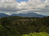
. It is located in the Wahiawa District, on the plateau or "central valley" between the two volcanic mountains that comprise the island. In Hawaiian
, wahi a wā means "place of noise", perhaps a reference to the fact that once upon a time, heavy surf on the distant coast could be heard here. The population was 16,151 at the 2000 census
.
Lakes and reservoirs are rare in Hawaii, and Wahiawa is at once unique in being surrounded on three sides by Lake Wilson (also known as Wahiawa Reservoir or Kaukonahua). The town must be accessed by either of two bridges on Kamehameha Highway (State Rte. 80) across the narrow north and south arms of the reservoir. Outside of the reservoir, the town used to be surrounded by military bases and agricultural fields, but development is making its way up from the increasingly urbanized southern portion of the central plain. Still, there are significant U.S. Army facilities here, including Schofield Barracks, Wheeler Army Airfield
, and East Range, an Army training area extending into the hills south and east of town. Schofield Barracks alone is larger than Wahiawa. Wahiawa is also the home of the U.S. Navy's
Naval Computer and Telecommunications Area Master Station Pacific
.
The U.S. postal code
for Wahiawa is 96786.
 Wahiawa is located at 21°30′9"N 158°1′23"W (21.502574, -158.022938).
Vehicular routes heading towards the North Shore from Wahiawa are Kamehameha Highway (State Rte. 80) to Haleiwa and Kaukonahua Road (State Rte. 801) to Waialua. Wheeler and Schofield are reached along Wilikina Drive(Wahiawa Bypass) (State Rte. 99), which bypasses Wahiawa from the south bridge, a road that eventually connects to both Kamehameha Highway and Kaukonahua Road northwest of town. Kamehameha Highway continues south (as State Rte. 99) past Wheeler to Mililani Town. However, the Interstate H-2
terminates at Wilikina Drive near the Kamehameha Highway intersection, and is a less congested route southward to Mililani and beyond to Pearl City
and Honolulu
via Interstate H-1
. Kunia Road (State Rte. 750) runs from Wilikina Dr., between Schofield and Wheeler (on the bypass), then southward along the mostly still agricultural western side of the plain to Kunia and Waipahu beyond.
According to the United States Census Bureau
, the CDP has a total area of 2.4 square miles (6.2 km²), of which, 2.1 square miles (5.5 km²) of it is land and 0.3 square miles (0.7 km²) of it (11.34%) is water.
Kaʻala the highest peak in Oahu (4,003 ft) is located in Wahiawa.
Wahiawa Reservoir or Lake Wilson is located in Wahiawa, the second largest reservoir in Hawaii (302 acres (1.2 km²)). It is used to irrigate agricultural fields including the Dole Pineapple Plantation fields located at the northern part of Wahiawa all the way towards Oahu's North Shore
where it empties.
of 2000, there were 16,151 people, 5,376 households, and 3,956 families residing in the CDP. The population density
was 7,642.8 people per square mile (2,955.4/km²). There were 5,900 housing units at an average density of 2,791.9 per square mile (1,079.6/km²). The racial makeup of the CDP was 11.31% White, 2.02% Black or African American, 0.32% Native American, 45.77% Asian, 9.62% Pacific Islander, 1.83% from other races, and 29.14% from two or more races. 11.00% of the population were Hispanic or Latino of any race.
There were 5,376 households out of which 31.3% had children under the age of 18 living with them, 49.2% were married couples
living together, 18.0% had a female householder with no husband present, and 26.4% were non-families. 21.9% of all households were made up of individuals and 10.5% had someone living alone who was 65 years of age or older. The average household size was 2.97 and the average family size was 3.45.
In the CDP the population was spread out with 26.1% under the age of 18, 8.6% from 18 to 24, 26.6% from 25 to 44, 19.9% from 45 to 64, and 18.8% who were 65 years of age or older. The median age was 38 years. For every 100 females there were 94.6 males. For every 100 females age 18 and over, there were 91.4 males.
The median income for a household in the CDP was $41,257, and the median income for a family was $46,524. Males had a median income of $32,018 versus $25,287 for females. The per capita income
for the CDP was $16,366. 16.7% of the population and 13.5% of families were below the poverty line. Out of the total population, 23.8% of those under the age of 18 and 9.9% of those 65 and older were living below the poverty line.
operates the Wahiawa Substation in Wahiawā.
A satellite gateway for the Iridium
satellite phone
network is operated by the DISA
in Wahiawa.
In the Hawaii State Legislature, Wahiawā is part of Hawaii State House of Representatives
district 39 (currently represented by Marcus Oshiro) and Hawaii State Senate
district 22 (currently represented by Donovan Dela Cruz.) In the Honolulu City Council
, Wahiawā is part of district 2 (currently represented by Ernest Y. Martin.)
Elementary schools in the CDP include Iliahi, Kaala, Samuel K. Solomon, and Wahiawa. Major Sheldon Wheeler is inside the CDP, while Wahiawa Middle School is adjacent to the CDP. Leilehua High School
is inside the CDP.
Census-designated place
A census-designated place is a concentration of population identified by the United States Census Bureau for statistical purposes. CDPs are delineated for each decennial census as the statistical counterparts of incorporated places such as cities, towns and villages...
(CDP) in Honolulu County
Honolulu County, Hawaii
The City and County of Honolulu is a consolidated city–county located in the U.S. state of Hawaii. The municipality and county includes both the urban district of Honolulu and the rest of the island of Oahu, as well as several minor outlying islands, including all of the Northwestern Hawaiian...
, Hawaii
Hawaii
Hawaii is the newest of the 50 U.S. states , and is the only U.S. state made up entirely of islands. It is the northernmost island group in Polynesia, occupying most of an archipelago in the central Pacific Ocean, southwest of the continental United States, southeast of Japan, and northeast of...
, United States
United States
The United States of America is a federal constitutional republic comprising fifty states and a federal district...
, on the island of Oahu
Oahu
Oahu or Oahu , known as "The Gathering Place", is the third largest of the Hawaiian Islands and most populous of the islands in the U.S. state of Hawaii. The state capital Honolulu is located on the southeast coast...
. It is located in the Wahiawa District, on the plateau or "central valley" between the two volcanic mountains that comprise the island. In Hawaiian
Hawaiian language
The Hawaiian language is a Polynesian language that takes its name from Hawaii, the largest island in the tropical North Pacific archipelago where it developed. Hawaiian, along with English, is an official language of the state of Hawaii...
, wahi a wā means "place of noise", perhaps a reference to the fact that once upon a time, heavy surf on the distant coast could be heard here. The population was 16,151 at the 2000 census
United States Census, 2000
The Twenty-second United States Census, known as Census 2000 and conducted by the Census Bureau, determined the resident population of the United States on April 1, 2000, to be 281,421,906, an increase of 13.2% over the 248,709,873 persons enumerated during the 1990 Census...
.
Lakes and reservoirs are rare in Hawaii, and Wahiawa is at once unique in being surrounded on three sides by Lake Wilson (also known as Wahiawa Reservoir or Kaukonahua). The town must be accessed by either of two bridges on Kamehameha Highway (State Rte. 80) across the narrow north and south arms of the reservoir. Outside of the reservoir, the town used to be surrounded by military bases and agricultural fields, but development is making its way up from the increasingly urbanized southern portion of the central plain. Still, there are significant U.S. Army facilities here, including Schofield Barracks, Wheeler Army Airfield
Wheeler Army Airfield
Wheeler Army Airfield , also known as Wheeler Field and formerly as Wheeler Air Force Base, is a United States Army post located in the City & County of Honolulu and in the Wahiawa District of the Island of O'ahu, Hawaii...
, and East Range, an Army training area extending into the hills south and east of town. Schofield Barracks alone is larger than Wahiawa. Wahiawa is also the home of the U.S. Navy's
United States Navy
The United States Navy is the naval warfare service branch of the United States Armed Forces and one of the seven uniformed services of the United States. The U.S. Navy is the largest in the world; its battle fleet tonnage is greater than that of the next 13 largest navies combined. The U.S...
Naval Computer and Telecommunications Area Master Station Pacific
Naval Computer and Telecommunications Area Master Station Pacific
Naval Computer and Telecommunications Area Master Station Pacific provides operational direction and management to all Pacific Naval Telecommunication System users...
.
The U.S. postal code
Postal code
A postal code is a series of letters and/or digits appended to a postal address for the purpose of sorting mail. Once postal codes were introduced, other applications became possible.In February 2005, 117 of the 190 member countries of the Universal Postal Union had postal code systems...
for Wahiawa is 96786.
Geography
Vehicular routes heading towards the North Shore from Wahiawa are Kamehameha Highway (State Rte. 80) to Haleiwa and Kaukonahua Road (State Rte. 801) to Waialua. Wheeler and Schofield are reached along Wilikina Drive(Wahiawa Bypass) (State Rte. 99), which bypasses Wahiawa from the south bridge, a road that eventually connects to both Kamehameha Highway and Kaukonahua Road northwest of town. Kamehameha Highway continues south (as State Rte. 99) past Wheeler to Mililani Town. However, the Interstate H-2
Interstate H-2
Interstate H-2 is an intrastate Interstate Highway located on the island of O‘ahu in Hawai‘i, USA. H-2 is also known as the Veterans Memorial Freeway. Despite the number, this is a north–south interstate—the 'H'-series numbering reflects the order in which routes were funded and built...
terminates at Wilikina Drive near the Kamehameha Highway intersection, and is a less congested route southward to Mililani and beyond to Pearl City
Pearl City, Hawaii
Pearl City is a census-designated place located in the Ewa District and City & County of Honolulu on the Island of Oahu. As of the 2010 Census, the CDP had a total population of 47,698. Pearl City is located along the north shore of Pearl Harbor. ʻAiea borders Pearl City to the east, while Waipahu...
and Honolulu
Honolulu, Hawaii
Honolulu is the capital and the most populous city of the U.S. state of Hawaii. Honolulu is the southernmost major U.S. city. Although the name "Honolulu" refers to the urban area on the southeastern shore of the island of Oahu, the city and county government are consolidated as the City and...
via Interstate H-1
Interstate H-1
Interstate H-1 is the busiest Interstate Highway in Hawaii, United States, located on the island of O‘ahu. Despite the number, this is an east–west highway—the 'H'-series numbering reflects the order in which routes were funded and built. H-1 goes from Route 93 in Kapolei to Route 72 in...
. Kunia Road (State Rte. 750) runs from Wilikina Dr., between Schofield and Wheeler (on the bypass), then southward along the mostly still agricultural western side of the plain to Kunia and Waipahu beyond.
According to the United States Census Bureau
United States Census Bureau
The United States Census Bureau is the government agency that is responsible for the United States Census. It also gathers other national demographic and economic data...
, the CDP has a total area of 2.4 square miles (6.2 km²), of which, 2.1 square miles (5.5 km²) of it is land and 0.3 square miles (0.7 km²) of it (11.34%) is water.
Kaʻala the highest peak in Oahu (4,003 ft) is located in Wahiawa.
Wahiawa Reservoir or Lake Wilson is located in Wahiawa, the second largest reservoir in Hawaii (302 acres (1.2 km²)). It is used to irrigate agricultural fields including the Dole Pineapple Plantation fields located at the northern part of Wahiawa all the way towards Oahu's North Shore
North Shore (Oahu)
The North Shore, in the context of geography of the Island of Oahu, refers to the north-facing coastal area of Oahu between Kaena Point and Kahuku Point...
where it empties.
Demographics
As of the censusCensus
A census is the procedure of systematically acquiring and recording information about the members of a given population. It is a regularly occurring and official count of a particular population. The term is used mostly in connection with national population and housing censuses; other common...
of 2000, there were 16,151 people, 5,376 households, and 3,956 families residing in the CDP. The population density
Population density
Population density is a measurement of population per unit area or unit volume. It is frequently applied to living organisms, and particularly to humans...
was 7,642.8 people per square mile (2,955.4/km²). There were 5,900 housing units at an average density of 2,791.9 per square mile (1,079.6/km²). The racial makeup of the CDP was 11.31% White, 2.02% Black or African American, 0.32% Native American, 45.77% Asian, 9.62% Pacific Islander, 1.83% from other races, and 29.14% from two or more races. 11.00% of the population were Hispanic or Latino of any race.
There were 5,376 households out of which 31.3% had children under the age of 18 living with them, 49.2% were married couples
Marriage
Marriage is a social union or legal contract between people that creates kinship. It is an institution in which interpersonal relationships, usually intimate and sexual, are acknowledged in a variety of ways, depending on the culture or subculture in which it is found...
living together, 18.0% had a female householder with no husband present, and 26.4% were non-families. 21.9% of all households were made up of individuals and 10.5% had someone living alone who was 65 years of age or older. The average household size was 2.97 and the average family size was 3.45.
In the CDP the population was spread out with 26.1% under the age of 18, 8.6% from 18 to 24, 26.6% from 25 to 44, 19.9% from 45 to 64, and 18.8% who were 65 years of age or older. The median age was 38 years. For every 100 females there were 94.6 males. For every 100 females age 18 and over, there were 91.4 males.
The median income for a household in the CDP was $41,257, and the median income for a family was $46,524. Males had a median income of $32,018 versus $25,287 for females. The per capita income
Per capita income
Per capita income or income per person is a measure of mean income within an economic aggregate, such as a country or city. It is calculated by taking a measure of all sources of income in the aggregate and dividing it by the total population...
for the CDP was $16,366. 16.7% of the population and 13.5% of families were below the poverty line. Out of the total population, 23.8% of those under the age of 18 and 9.9% of those 65 and older were living below the poverty line.
Government and infrastructure
The Honolulu Police DepartmentHonolulu Police Department
The Honolulu Police Department is the principal law enforcement agency of the City and County of Honolulu, Hawai'i, headquartered in the Alapa'i Police Headquarters in Honolulu CDP....
operates the Wahiawa Substation in Wahiawā.
A satellite gateway for the Iridium
Iridium (satellite)
Iridium Communications Inc. is a company, based in McLean, VA, United States which operates the Iridium satellite constellation, a system of 66 active satellites used for worldwide voice and data communication from hand-held satellite phones and other transceiver units...
satellite phone
Satellite phone
A satellite telephone, satellite phone, or satphone is a type of mobile phone that connects to orbiting satellites instead of terrestrial cell sites...
network is operated by the DISA
Disa
Disa is the heroine of a Swedish legendary saga, which was documented by Olaus Magnus, in 1555. It is believed to be from the Middle Ages, but includes Old Norse themes....
in Wahiawa.
In the Hawaii State Legislature, Wahiawā is part of Hawaii State House of Representatives
Hawaii House of Representatives
The Hawaii House of Representatives is the lower house of the Hawaii State Legislature. Accord to Article III, Section 3 of the Hawaii Constitution, amended during the 1978 constitutional convention, the House of Representatives consists of 51 members representing an equal amount of districts...
district 39 (currently represented by Marcus Oshiro) and Hawaii State Senate
Hawaii Senate
The Hawaii State Senate is the upper chamber of the Hawaii State Legislature. The senate consists of twenty-five members elected from an equal number of constituent districts across the islands. The senate is led by the President of the Senate, elected from the membership of the body, currently...
district 22 (currently represented by Donovan Dela Cruz.) In the Honolulu City Council
Honolulu City Council
The Honolulu City Council is the legislative branch of the City & County of Honolulu and is considered the second most powerful parliamentary body in the State of Hawaii, following the Hawaii State Legislature...
, Wahiawā is part of district 2 (currently represented by Ernest Y. Martin.)
Public schools
Hawaii State Department of Education operates public schools.Elementary schools in the CDP include Iliahi, Kaala, Samuel K. Solomon, and Wahiawa. Major Sheldon Wheeler is inside the CDP, while Wahiawa Middle School is adjacent to the CDP. Leilehua High School
Leilehua High School
Leilehua High School is a public, co-educational, college preparatory high school in Wahiawa, Hawaii on the island of Oahu. It is part of the Hawaii State Department of Education, nationally recognized as a Blue Ribbon School by the United States Department of Education, and fully accredited by the...
is inside the CDP.
Private schools
Elementary School- Trinity Lutheran Church and School (Lutheran)
- First Baptist Church
- Ho'ala School
- Abundant Life United Pent Church
- Maranatha Christian Academy
- Hawaii Matsuritaiko
Notable residents
- Al HarrisAl Harris (defensive lineman)Alfred Carl Harris is a former professional American football defensive end and linebacker in the National Football League for the Chicago Bears during the early 1980s. He played with the team from 1979 to 1984...
, professional football player - Lia Marie Johnson, actress, singer
- Adrian MurrellAdrian MurrellAdrian Byran Murrell is a former professional American football running back who was drafted by the New York Jets in the fifth round of the 1993 NFL Draft after playing collegiately for the West Virginia Mountaineers...
, professional football player - Kealoha PilaresKealoha PilaresKealoha Pilares is an American football wide receiver for the Carolina Panthers. He was drafted by the Panthers in the fifth round of the 2011 NFL Draft. He played college football at the University of Hawaii at Manoa. He partially tore his PCL in the 2010 Hawai'i Bowl....
, professional football player - Lauvale SapeLauvale SapeLauvale Sape [la-VAH-lay sah-PAY] is an American football defensive tackle for the Las Vegas Locomotives of the United Football League. He was drafted by the Buffalo Bills in the sixth round of the 2003 NFL Draft...
, professional football player - Antonio TagubaAntonio TagubaAntonio Mario Taguba , is a retired major general in the United States Army. He was the second American citizen of Philippine birth to be promoted to general officer rank in the Army....
, military general