
Virginia State Route 353
Encyclopedia
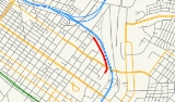
State Route 353 is a primary state highway
in the U.S. state
of Virginia
. It is located in Richmond, Virginia
, next to Interstate 95 just south of its split with Interstate 64.
 The State Route 353 designation is assigned to "roads in the grounds of Virginia Commonwealth University (Medical Center Campus)
at City of Richmond." Though it has formerly included other roads, it is now only Duval Street Connection between 8th Street and the Main Hospital on 13th Street.
Although located entirely within the city and connecting city-maintained streets, Route 353 is maintained by the state, and, despite its short length, a single reassurance shield can be found westbound just after entering the route from 13th Street.
SR 353 was first added to the state highway system in 1942, when 0.015 miles (0.024 km) from the end of East Clay Street south to the central power plant were taken over by the state. The current SR 353 was built in the 1950s as part of the Richmond-Petersburg Turnpike
project, and the original roadway was removed from the system in 1973.
State highway
State highway, state road or state route can refer to one of three related concepts, two of them related to a state or provincial government in a country that is divided into states or provinces :#A...
in the U.S. state
U.S. state
A U.S. state is any one of the 50 federated states of the United States of America that share sovereignty with the federal government. Because of this shared sovereignty, an American is a citizen both of the federal entity and of his or her state of domicile. Four states use the official title of...
of Virginia
Virginia
The Commonwealth of Virginia , is a U.S. state on the Atlantic Coast of the Southern United States. Virginia is nicknamed the "Old Dominion" and sometimes the "Mother of Presidents" after the eight U.S. presidents born there...
. It is located in Richmond, Virginia
Richmond, Virginia
Richmond is the capital of the Commonwealth of Virginia, in the United States. It is an independent city and not part of any county. Richmond is the center of the Richmond Metropolitan Statistical Area and the Greater Richmond area...
, next to Interstate 95 just south of its split with Interstate 64.
VCU Medical Center
VCU Medical Center, is Virginia Commonwealth University's medical campus located in downtown Richmond, Virginia in the Court End neighborhood. The VCU Medical Center used to be known as the Medical College of Virginia until it merged with the Richmond Professional Institute in 1968 to create...
at City of Richmond." Though it has formerly included other roads, it is now only Duval Street Connection between 8th Street and the Main Hospital on 13th Street.
Although located entirely within the city and connecting city-maintained streets, Route 353 is maintained by the state, and, despite its short length, a single reassurance shield can be found westbound just after entering the route from 13th Street.
SR 353 was first added to the state highway system in 1942, when 0.015 miles (0.024 km) from the end of East Clay Street south to the central power plant were taken over by the state. The current SR 353 was built in the 1950s as part of the Richmond-Petersburg Turnpike
Richmond-Petersburg Turnpike
The Richmond-Petersburg Turnpike was a toll road located in the Richmond-Petersburg region of central Virginia, USA.After World War II, major traffic congestion occurred in the area around Richmond and Petersburg along U.S. Route 1 and U.S. Route 301...
project, and the original roadway was removed from the system in 1973.