
Richmond-Petersburg Turnpike
Encyclopedia
The Richmond-Petersburg Turnpike was a toll road
located in the Richmond-Petersburg
region of central Virginia
, USA.
After World War II
, major traffic congestion occurred in the area around Richmond
and Petersburg
along U.S. Route 1
and U.S. Route 301
. This was particularly true where these two major routes shared the same roadway for much of the distance between the two cities, as well as bridges across the James River
and Appomattox River
.
To help alleviate the problems, in 1955 the Virginia General Assembly
created a political subdivision
, the Richmond Petersburg Turnpike Authority. The authority was administered by a board of directors. Its members were appointed by the local governing bodies of the jurisdictions through which the turnpike passed, one member from each locality. It was given the mission to sell toll revenue bond
s to build and operate a new toll highway parallel to the existing Routes 1 and 301 between Henrico County
just north of Richmond and Dinwiddie County
just south of Petersburg, with new bridges over the two major rivers. Opened in 1958, and funded through toll revenue bond
s, it was conceived prior to the creation of the Interstate Highway System
.
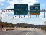
Tolls were removed completely in 1992. Today, the former Richmond-Petersburg Turnpike forms 30 miles (48.3 km) of Interstate 95
in central Virginia, as well as the northernmost 5 miles (8 km) of Interstate 85
in Petersburg and Dinwiddie County.
and in 1926 was also designated U.S. Routes 1 and 301. Some Chesterfield County and Colonial Heights land deeds still reference the name Richmond-Petersburg Turnpike for properties along Jefferson Davis Highway. Historical accounts of 1864 Civil War events mention that name as well.
, the busy north–south corridor in central Virginia shared by US 1 and US 301 and the Jefferson Davis Memorial Highway through the cities of Richmond, Colonial Heights
and Petersburg and along the Jefferson Davis Highway
between the cities was heavily-developed commercially. With only four traffic lanes and long stretches of undivided roadway, it became a major area of traffic congestion, as well as the site of occasional spectacular and deadly head-on collisions.
In 1955, prior to the creation of the U.S. Interstate Highway System
, the Virginia General Assembly
created the Richmond-Petersburg Turnpike Authority as an independent state agency to administer (design, finance, acquire right-of-way, construct, operate, collect tolls, and maintain) the new Turnpike of the same name. The new toll road
was planned with only 15 exits, and most of these were well away from the highly developed commercial areas along parallel U.S. 1-301.
 Funded with proceeds from toll revenue bond
s sold by the Authority, the 34.7 miles (55.8 km)-long road cost $76.7 million to build, including new bridges over the James River
in Richmond
and the Appomattox River
between Colonial Heights
and Petersburg
. It featured six lanes from the northern entrance to just south of the new James River Bridge in Richmond, and four lanes from that point south. At Petersburg, the new Turnpike split into two branches, one leading to US 301 south towards Emporia
and Weldon, North Carolina
, and the other to US 1 south, which led to South Hill
and Raleigh, North Carolina
.
The new expressway opened on July 1, 1958, and in August, the State Highway Commission designated it as part of Interstate 95. A piece near Petersburg was designated Interstate 85, and the Turnpike became a grandfathered part of the U.S. Interstate Highway System
even though no federal aid was used to build it. The new roadway achieved the intended diversion of long distance traffic. As earlier feared, hotels, motels, tourist homes and cabins, and restaurants along the bypassed highways suffered tremendous loss of business, and many failed. However, due to the relatively high rate of tolls on the Turnpike, the blow was softened by a continually increasing traffic flow and patronage of motorists wanting to avoid the tolls, who continued to use the old roads. This practice of avoiding roads and bridges with tolls is known as "shunpiking
".
passed legislation which transferred the Authority's duties to the Virginia Department of Highways, the predecessor agency to the Virginia Department of Transportation
(VDOT). The Authority as an independent entity ceased to exist and the Board of Directors disbanded. In December 1973, additional bonds were issued to provide much-needed improvements to the heavily traveled highway. Unlike the original toll revenue bonds which were backed only by toll revenue, the new bonds were backed by the Commonwealth of Virginia. They were still funded by toll revenue but the bondholders had more security with state backing and thus offered lower interest rates. A primary factor in turning the turnpike over to the Virginia Department of Highways was to obtain full state control since the state was taking the risk on the bonds.
The improvements included widening to six lanes of 22 miles (35.4 km) from just south of the James River Bridge at Richmond and complete reconstruction of the I-85 and I-95 interchange in downtown Petersburg. Several other major interchanges including Chester/Hopewell and Broad Street at downtown Richmond were also reconstructed.
Once the bonds were paid off, toll revenue funded safety improvements on the entire turnpike which included sign and guardrail replacements as well as replacing most of the median guardrail with Jersey style concrete median barriers. Toll money was also spent on nearby road projects such as the Temple Avenue extension (State Route 144). Since interstate travelers were paying most of the tolls that was then being spent on other projects, toll removal became a local political issue that the General Assembly eventually decided to approximately coincide with the opening of the parallel Interstate 295.
and the Richmond International Airport
.
Today, the former Richmond-Petersburg Turnpike with the I-95 designation, and parallel Interstate 295
(which forms an eastern bypass of Richmond and Petersburg) carry some of the heaviest traffic flows of any portion of the busy eastern U.S. corridor between Florida and New England.
Toll road
A toll road is a privately or publicly built road for which a driver pays a toll for use. Structures for which tolls are charged include toll bridges and toll tunnels. Non-toll roads are financed using other sources of revenue, most typically fuel tax or general tax funds...
located in the Richmond-Petersburg
Richmond-Petersburg
The Greater Richmond Region is a region located in a central part of the state of Virginia in the United States. As of 2010, it had a population of 1,258,251, making it the 43rd largest MSA in the country...
region of central Virginia
Virginia
The Commonwealth of Virginia , is a U.S. state on the Atlantic Coast of the Southern United States. Virginia is nicknamed the "Old Dominion" and sometimes the "Mother of Presidents" after the eight U.S. presidents born there...
, USA.
After World War II
World War II
World War II, or the Second World War , was a global conflict lasting from 1939 to 1945, involving most of the world's nations—including all of the great powers—eventually forming two opposing military alliances: the Allies and the Axis...
, major traffic congestion occurred in the area around Richmond
Richmond, Virginia
Richmond is the capital of the Commonwealth of Virginia, in the United States. It is an independent city and not part of any county. Richmond is the center of the Richmond Metropolitan Statistical Area and the Greater Richmond area...
and Petersburg
Petersburg, Virginia
Petersburg is an independent city in Virginia, United States located on the Appomattox River and south of the state capital city of Richmond. The city's population was 32,420 as of 2010, predominantly of African-American ethnicity...
along U.S. Route 1
U.S. Route 1
U.S. Route 1 is a major north–south U.S. Highway that serves the East Coast of the United States. It runs 2,377 miles from Fort Kent, Maine at the Canadian border south to Key West, Florida. U.S. 1 generally parallels Interstate 95, though it is significantly farther west between...
and U.S. Route 301
U.S. Route 301
U.S. Route 301 is a spur of U.S. Route 1 running through the South Atlantic States. It currently runs 1,099 miles from Glasgow, Delaware at U.S. Route 40 to Sarasota, Florida. It passes through the states of Delaware, Maryland, Virginia, North Carolina, South Carolina, Georgia, and Florida...
. This was particularly true where these two major routes shared the same roadway for much of the distance between the two cities, as well as bridges across the James River
James River (Virginia)
The James River is a river in the U.S. state of Virginia. It is long, extending to if one includes the Jackson River, the longer of its two source tributaries. The James River drains a catchment comprising . The watershed includes about 4% open water and an area with a population of 2.5 million...
and Appomattox River
Appomattox River
The Appomattox River is a tributary of the James River, approximately long, in central and eastern Virginia in the United States, named for the Appomattocs Indian tribe who lived along its lower banks in the 17th century...
.
To help alleviate the problems, in 1955 the Virginia General Assembly
Virginia General Assembly
The Virginia General Assembly is the legislative body of the Commonwealth of Virginia, and the oldest legislative body in the Western Hemisphere, established on July 30, 1619. The General Assembly is a bicameral body consisting of a lower house, the Virginia House of Delegates, with 100 members,...
created a political subdivision
Political subdivisions of Virginia
The political subdivisions of Virginia are the areas into which the Commonwealth of Virginia, a U.S. state, is divided for political and administrative purposes. Some are local governments; others are not...
, the Richmond Petersburg Turnpike Authority. The authority was administered by a board of directors. Its members were appointed by the local governing bodies of the jurisdictions through which the turnpike passed, one member from each locality. It was given the mission to sell toll revenue bond
Toll revenue bond
A toll revenue bond is a financial promissory note usually issued to generate funds for the construction and/or operation of a public accommodation such as an expressway, bridge, or tunnel...
s to build and operate a new toll highway parallel to the existing Routes 1 and 301 between Henrico County
Henrico County, Virginia
Henrico is a county located in the Commonwealth of Virginia, a state of the United States. As of 2010, Henrico was home to 306,935 people. It is located in the Richmond-Petersburg region and is a portion of the Richmond Metropolitan Statistical Area...
just north of Richmond and Dinwiddie County
Dinwiddie County, Virginia
Dinwiddie County is a county located in the Commonwealth of Virginia. As of 2010, the population was 28,001. Its county seat is Dinwiddie.- History :...
just south of Petersburg, with new bridges over the two major rivers. Opened in 1958, and funded through toll revenue bond
Toll revenue bond
A toll revenue bond is a financial promissory note usually issued to generate funds for the construction and/or operation of a public accommodation such as an expressway, bridge, or tunnel...
s, it was conceived prior to the creation of the Interstate Highway System
Interstate Highway System
The Dwight D. Eisenhower National System of Interstate and Defense Highways, , is a network of limited-access roads including freeways, highways, and expressways forming part of the National Highway System of the United States of America...
.
Tolls were removed completely in 1992. Today, the former Richmond-Petersburg Turnpike forms 30 miles (48.3 km) of Interstate 95
Interstate 95 in Virginia
In the Commonwealth of Virginia, Interstate 95 runs through the state. It runs concurrently for with Interstate 64 in Richmond, and meets the northern terminus of Interstate 85 in Petersburg. Though Interstate 95 was originally planned to go straight through Washington, D.C., it was instead...
in central Virginia, as well as the northernmost 5 miles (8 km) of Interstate 85
Interstate 85
Interstate 85 is a major interstate highway in the Southeastern United States. Its current southern terminus is at an interchange with Interstate 65 in Montgomery, Alabama; its northern terminus interchanges with Interstate 95 in Petersburg, Virginia, near Richmond...
in Petersburg and Dinwiddie County.
History
In 1826, a privately-operated toll road known as the Manchester and Petersburg Turnpike opened that extended through Chesterfield County between Richmond and Petersburg. At some point it became known as the Richmond and Petersburg Turnpike. In 1922 much of that route was renamed Jefferson Davis HighwayJefferson Davis Highway
The Jefferson Davis Memorial Highway was a planned transcontinental highway in the United States in the 1910s and 1920s that began in Washington, D.C. and extended south and west to San Diego, California; it was named for Jefferson Davis, who, in addition to being the first and only President of...
and in 1926 was also designated U.S. Routes 1 and 301. Some Chesterfield County and Colonial Heights land deeds still reference the name Richmond-Petersburg Turnpike for properties along Jefferson Davis Highway. Historical accounts of 1864 Civil War events mention that name as well.
Richmond-Petersburg Turnpike Authority
After World War IIWorld War II
World War II, or the Second World War , was a global conflict lasting from 1939 to 1945, involving most of the world's nations—including all of the great powers—eventually forming two opposing military alliances: the Allies and the Axis...
, the busy north–south corridor in central Virginia shared by US 1 and US 301 and the Jefferson Davis Memorial Highway through the cities of Richmond, Colonial Heights
Colonial Heights, Virginia
Colonial Heights is an independent city in Virginia, United States. The population was 17,411 as of 2010. The Bureau of Economic Analysis combines the City of Colonial Heights with Dinwiddie County for statistical purposes...
and Petersburg and along the Jefferson Davis Highway
Jefferson Davis Highway
The Jefferson Davis Memorial Highway was a planned transcontinental highway in the United States in the 1910s and 1920s that began in Washington, D.C. and extended south and west to San Diego, California; it was named for Jefferson Davis, who, in addition to being the first and only President of...
between the cities was heavily-developed commercially. With only four traffic lanes and long stretches of undivided roadway, it became a major area of traffic congestion, as well as the site of occasional spectacular and deadly head-on collisions.
In 1955, prior to the creation of the U.S. Interstate Highway System
Interstate Highway System
The Dwight D. Eisenhower National System of Interstate and Defense Highways, , is a network of limited-access roads including freeways, highways, and expressways forming part of the National Highway System of the United States of America...
, the Virginia General Assembly
Virginia General Assembly
The Virginia General Assembly is the legislative body of the Commonwealth of Virginia, and the oldest legislative body in the Western Hemisphere, established on July 30, 1619. The General Assembly is a bicameral body consisting of a lower house, the Virginia House of Delegates, with 100 members,...
created the Richmond-Petersburg Turnpike Authority as an independent state agency to administer (design, finance, acquire right-of-way, construct, operate, collect tolls, and maintain) the new Turnpike of the same name. The new toll road
Toll road
A toll road is a privately or publicly built road for which a driver pays a toll for use. Structures for which tolls are charged include toll bridges and toll tunnels. Non-toll roads are financed using other sources of revenue, most typically fuel tax or general tax funds...
was planned with only 15 exits, and most of these were well away from the highly developed commercial areas along parallel U.S. 1-301.
Toll revenue bond
A toll revenue bond is a financial promissory note usually issued to generate funds for the construction and/or operation of a public accommodation such as an expressway, bridge, or tunnel...
s sold by the Authority, the 34.7 miles (55.8 km)-long road cost $76.7 million to build, including new bridges over the James River
James River (Virginia)
The James River is a river in the U.S. state of Virginia. It is long, extending to if one includes the Jackson River, the longer of its two source tributaries. The James River drains a catchment comprising . The watershed includes about 4% open water and an area with a population of 2.5 million...
in Richmond
Richmond, Virginia
Richmond is the capital of the Commonwealth of Virginia, in the United States. It is an independent city and not part of any county. Richmond is the center of the Richmond Metropolitan Statistical Area and the Greater Richmond area...
and the Appomattox River
Appomattox River
The Appomattox River is a tributary of the James River, approximately long, in central and eastern Virginia in the United States, named for the Appomattocs Indian tribe who lived along its lower banks in the 17th century...
between Colonial Heights
Colonial Heights, Virginia
Colonial Heights is an independent city in Virginia, United States. The population was 17,411 as of 2010. The Bureau of Economic Analysis combines the City of Colonial Heights with Dinwiddie County for statistical purposes...
and Petersburg
Petersburg, Virginia
Petersburg is an independent city in Virginia, United States located on the Appomattox River and south of the state capital city of Richmond. The city's population was 32,420 as of 2010, predominantly of African-American ethnicity...
. It featured six lanes from the northern entrance to just south of the new James River Bridge in Richmond, and four lanes from that point south. At Petersburg, the new Turnpike split into two branches, one leading to US 301 south towards Emporia
Emporia, Virginia
Emporia is an independent city located within the confines of Greensville County, Virginia, United States. The population was estimated to be 5,927 in 2010. The Bureau of Economic Analysis combines the city of Emporia with surrounding Greensville county for statistical purposes...
and Weldon, North Carolina
Weldon, North Carolina
Weldon is a town in Halifax County, North Carolina, United States. The population was 1,374 at the 2000 census. It is part of the Roanoke Rapids, North Carolina Micropolitan Statistical Area.-Geography:Weldon is located at ....
, and the other to US 1 south, which led to South Hill
South Hill, Virginia
South Hill is a town in Mecklenburg County, Virginia, United States. As of the 2006 census, the town population was 4,608. Located on major Interstate and U.S. highways, it has a full service hospital , a tobacco market, and several hotels. South Hill has a close relationship with the neighboring...
and Raleigh, North Carolina
Raleigh, North Carolina
Raleigh is the capital and the second largest city in the state of North Carolina as well as the seat of Wake County. Raleigh is known as the "City of Oaks" for its many oak trees. According to the U.S. Census Bureau, the city's 2010 population was 403,892, over an area of , making Raleigh...
.
The new expressway opened on July 1, 1958, and in August, the State Highway Commission designated it as part of Interstate 95. A piece near Petersburg was designated Interstate 85, and the Turnpike became a grandfathered part of the U.S. Interstate Highway System
Interstate Highway System
The Dwight D. Eisenhower National System of Interstate and Defense Highways, , is a network of limited-access roads including freeways, highways, and expressways forming part of the National Highway System of the United States of America...
even though no federal aid was used to build it. The new roadway achieved the intended diversion of long distance traffic. As earlier feared, hotels, motels, tourist homes and cabins, and restaurants along the bypassed highways suffered tremendous loss of business, and many failed. However, due to the relatively high rate of tolls on the Turnpike, the blow was softened by a continually increasing traffic flow and patronage of motorists wanting to avoid the tolls, who continued to use the old roads. This practice of avoiding roads and bridges with tolls is known as "shunpiking
Shunpiking
The term shunpiking comes from the word shun, meaning "to avoid", and pike, a term referring to turnpikes, which are roads that require payment of a toll to travel on them...
".
Expansion
The original toll revenue bonds were retired in 1975. However, in 1973, the General AssemblyVirginia General Assembly
The Virginia General Assembly is the legislative body of the Commonwealth of Virginia, and the oldest legislative body in the Western Hemisphere, established on July 30, 1619. The General Assembly is a bicameral body consisting of a lower house, the Virginia House of Delegates, with 100 members,...
passed legislation which transferred the Authority's duties to the Virginia Department of Highways, the predecessor agency to the Virginia Department of Transportation
Virginia Department of Transportation
The Virginia Department of Transportation is the agency of state government responsible for transportation in the state of Virginia in the United States. Headquartered in Downtown Richmond, VDOT is responsible for building, maintaining, and operating the roads, bridges and tunnels in the...
(VDOT). The Authority as an independent entity ceased to exist and the Board of Directors disbanded. In December 1973, additional bonds were issued to provide much-needed improvements to the heavily traveled highway. Unlike the original toll revenue bonds which were backed only by toll revenue, the new bonds were backed by the Commonwealth of Virginia. They were still funded by toll revenue but the bondholders had more security with state backing and thus offered lower interest rates. A primary factor in turning the turnpike over to the Virginia Department of Highways was to obtain full state control since the state was taking the risk on the bonds.
The improvements included widening to six lanes of 22 miles (35.4 km) from just south of the James River Bridge at Richmond and complete reconstruction of the I-85 and I-95 interchange in downtown Petersburg. Several other major interchanges including Chester/Hopewell and Broad Street at downtown Richmond were also reconstructed.
Once the bonds were paid off, toll revenue funded safety improvements on the entire turnpike which included sign and guardrail replacements as well as replacing most of the median guardrail with Jersey style concrete median barriers. Toll money was also spent on nearby road projects such as the Temple Avenue extension (State Route 144). Since interstate travelers were paying most of the tolls that was then being spent on other projects, toll removal became a local political issue that the General Assembly eventually decided to approximately coincide with the opening of the parallel Interstate 295.
Tolls removed, modernization
Tolls were removed from all portions of the former Richmond-Petersburg Turnpike in 1992, although the road now connects with several newer locally oriented toll facilities, including Richmond Metropolitan Authority's Downtown Expressway (State Route 195) which interchanges with the former Turnpike on the I-95 James River Bridge, and the Pocahontas Parkway (State Route 895) which connects I-95 at exit 67 with Interstate 295Interstate 295 (Virginia)
Interstate 295 is an eastern and northern bypass of the cities of Richmond and Petersburg in the U.S. state of Virginia. The southern terminus is a junction with Interstate 95 southeast of Petersburg...
and the Richmond International Airport
Richmond International Airport
- Accidents and incidents :*In 1996, Eastwind Airlines Flight 517 from Trenton experienced loss of rudder control while on approach to Richmond, however rudder control was regained shortly after and the aircraft landed normally. There was one minor injury....
.
Today, the former Richmond-Petersburg Turnpike with the I-95 designation, and parallel Interstate 295
Interstate 295 (Virginia)
Interstate 295 is an eastern and northern bypass of the cities of Richmond and Petersburg in the U.S. state of Virginia. The southern terminus is a junction with Interstate 95 southeast of Petersburg...
(which forms an eastern bypass of Richmond and Petersburg) carry some of the heaviest traffic flows of any portion of the busy eastern U.S. corridor between Florida and New England.
Exit list
| Number | Mile | Destinations | Notes | |
|---|---|---|---|---|
| Old | ||||
| 63 | 1 | U.S. Route 1 U.S. Route 1 U.S. Route 1 is a major north–south U.S. Highway that serves the East Coast of the United States. It runs 2,377 miles from Fort Kent, Maine at the Canadian border south to Key West, Florida. U.S. 1 generally parallels Interstate 95, though it is significantly farther west between... (U.S. Route 460 Business) |
split into 63A and 63B | |
| former Dinwiddie County barrier toll | ||||
| 65 | Squirrel Level Road | |||
| 68 | 2 | Interstate 95 Interstate 95 in Virginia In the Commonwealth of Virginia, Interstate 95 runs through the state. It runs concurrently for with Interstate 64 in Richmond, and meets the northern terminus of Interstate 85 in Petersburg. Though Interstate 95 was originally planned to go straight through Washington, D.C., it was instead... south; U.S. Route 460 U.S. Route 460 U.S. Route 460 is a spur of U.S. Route 60. It currently runs for 655 miles from Norfolk, Virginia at U.S. Route 60 at Ocean View to Frankfort, Kentucky at U.S. Route 60. It passes through the states of Virginia, West Virginia, and Kentucky... east - Rocky Mount, North Carolina Rocky Mount, North Carolina Rocky Mount is an All-America City Award-winning city in Edgecombe and Nash counties in the coastal plains of the state of North Carolina. Although it was not formally incorporated until February 28, 1867, the North Carolina community that became the city of Rocky Mount dates from the beginning of... ; Norfolk; Miami, Florida Miami, Florida Miami is a city located on the Atlantic coast in southeastern Florida and the county seat of Miami-Dade County, the most populous county in Florida and the eighth-most populous county in the United States with a population of 2,500,625... |
I-85 ends northbound and begins southbound; I-95 joins northbound and leaves southbound; US 460 leaves northbound and joins southbound; Turnpike takes exit 51 from I-95 south | |
| 69 | 3 | Wythe Street; Washington Street — Downtown (U.S. Route 301 U.S. Route 301 U.S. Route 301 is a spur of U.S. Route 1 running through the South Atlantic States. It currently runs 1,099 miles from Glasgow, Delaware at U.S. Route 40 to Sarasota, Florida. It passes through the states of Delaware, Maryland, Virginia, North Carolina, South Carolina, Georgia, and Florida... ; U.S. Route 460 Business) |
exit 52 southbound | |
| 52 | Bank Street | northbound exit only | ||
| 53 | Southpark Boulevard | |||
| 54 | 4 | Route 144 - Temple Avenue | This is the primary exit ramp for Southpark Mall Southpark Mall (Colonial Heights, Virginia) Southpark Mall is a shopping mall serving the Tri-Cities, Virginia area, which itself is part of the much larger Richmond-Petersburg metropolitan area.-Mall Description:... and much of the other new commercial development in the Tri-cities Tri-Cities, Virginia The Tri-Cities of Virginia is an area in the Greater Richmond Region which includes the three independent cities of Petersburg, Colonial Heights, and Hopewell and portions of the adjoining counties of Chesterfield, Dinwiddie, and Prince George in south-central Virginia... area that has occurred since the toll roads were removed. |
|
| 58 | 5 | Route 746; Route 620 - Ruffin Mill Road; Woods Edge Road | split into 58A and 58B southbound. Interchange was originally named Walthall. | |
| 61 | 6 | Route 10 - Hopewell; Chester | split into 61A and 61B (old 6E and 6W; originally 6 with only one exit) | |
| 62 | 6 | Route 288 - Chesterfield; to Powhite Parkway | ||
| 64 | 6A | Route 613 - Willis Road | ||
| 67A | Route 895 east | |||
| 67B | 7 | Route 150 north; Chippenham Parkway to U.S. Route 60 U.S. Route 60 U.S. Route 60 is an east–west United States highway, running from the Atlantic Ocean on the east coast in Virginia to western Arizona. Despite the final "0" in its number, indicating a transcontinental designation, the 1926 route formerly ended in Springfield, Missouri, at its intersection... ; U.S. Route 360 U.S. Route 360 U.S. Route 360 is a spur of US 60 in the U.S. state of Virginia. The U.S. Highway runs from US 58 Business, Virginia State Route 293, and SR 360 in Danville east to SR 644 in Reedville. US 360 connects Danville, South Boston, and Keysville in Southside Virginia with the state capital of... west |
formerly exit 67; former Falling Creek Falling Creek, Virginia Falling Creek, Virginia, was an unincorporated location along Interstate 95 near the point where a local tributary, Falling Creek, has its confluence with the James River. It was perhaps best known as the site of one of the toll barriers on the Richmond-Petersburg Turnpike, completed in 1958... barrier toll between the exit and entrance ramps |
|
| 69 | 8 | Route 161 - Bells Road | ||
| 73 | 9 | Maury Street; Commerce Road | ||
| 74A | 9A | Route 195 to Interstate 195 Interstate 195 (Virginia) Interstate 195 is an Interstate Highway in the U.S. state of Virginia. Known as the Beltline Expressway, the highway runs from Virginia State Route 195 , a toll road that continues south into Downtown Richmond, north to I-64 and I-95 on the northern edge of Richmond. I-195 passes through the West... north - Downtown Expressway to Powhite Parkway |
||
| 74B | 10A | Franklin Street | southbound exit only | |
| 74C | 10 | U.S. Route 33 U.S. Route 33 U.S. Route 33 is a United States federal highway that runs northwest-southeast for 709 miles from northern Indiana to Richmond, Virginia, passing through Ohio and West Virginia en route. Although most odd-numbered U.S... ; U.S. Route 250 U.S. Route 250 U.S. Route 250 is a route of the United States Numbered Highway System, and is a spur of U.S. Route 50. It currently runs for from Sandusky, Ohio to Richmond, Virginia. It passes through the states of Virginia, West Virginia, and Ohio. It goes through the cities of Richmond, Virginia,... - Broad Street |
||
| 75 | 11 | Interstate 64 Interstate 64 Interstate 64 is an Interstate Highway in the Midwestern and Southeastern United States. Its western terminus is at I-70, U.S. 40, and U.S. 61 in Wentzville, Missouri. Its eastern terminus is at an interchange with I-264 and I-664 at Bowers Hill in Chesapeake, Virginia. As I-64 is concurrent with... east - Williamsburg; Norfolk; Virginia Beach; 7th Street |
I-64 joins northbound and leaves southbound | |
| 76A | 12 | Chamberlayne Avenue | northbound exit and southbound entrance | |
| 76B | 13 | U.S. Route 1 U.S. Route 1 U.S. Route 1 is a major north–south U.S. Highway that serves the East Coast of the United States. It runs 2,377 miles from Fort Kent, Maine at the Canadian border south to Key West, Florida. U.S. 1 generally parallels Interstate 95, though it is significantly farther west between... ; U.S. Route 301 U.S. Route 301 U.S. Route 301 is a spur of U.S. Route 1 running through the South Atlantic States. It currently runs 1,099 miles from Glasgow, Delaware at U.S. Route 40 to Sarasota, Florida. It passes through the states of Delaware, Maryland, Virginia, North Carolina, South Carolina, Georgia, and Florida... - Belvidere Street |
no northbound exit | |
| former Belvidere barrier toll | ||||
| 78 | 14 | Boulevard (Route 161) | ||
| 79 | 15A | Interstate 64 Interstate 64 Interstate 64 is an Interstate Highway in the Midwestern and Southeastern United States. Its western terminus is at I-70, U.S. 40, and U.S. 61 in Wentzville, Missouri. Its eastern terminus is at an interchange with I-264 and I-664 at Bowers Hill in Chesapeake, Virginia. As I-64 is concurrent with... west; Interstate 195 Interstate 195 (Virginia) Interstate 195 is an Interstate Highway in the U.S. state of Virginia. Known as the Beltline Expressway, the highway runs from Virginia State Route 195 , a toll road that continues south into Downtown Richmond, north to I-64 and I-95 on the northern edge of Richmond. I-195 passes through the West... south to Powhite Parkway - Charlottesville |
I-64 joins southbound and leaves northbound | |
| 80 | 15 | Route 161 - Hermitage Road; Lakeside Avenue | northbound exit and southbound entrance | |
| 81 | 16 | U.S. Route 1 U.S. Route 1 U.S. Route 1 is a major north–south U.S. Highway that serves the East Coast of the United States. It runs 2,377 miles from Fort Kent, Maine at the Canadian border south to Key West, Florida. U.S. 1 generally parallels Interstate 95, though it is significantly farther west between... |
northbound exit and southbound entrance | |
| 82 | 17 | U.S. Route 301 U.S. Route 301 U.S. Route 301 is a spur of U.S. Route 1 running through the South Atlantic States. It currently runs 1,099 miles from Glasgow, Delaware at U.S. Route 40 to Sarasota, Florida. It passes through the states of Delaware, Maryland, Virginia, North Carolina, South Carolina, Georgia, and Florida... ; Route 2 - Chamberlayne Avenue |
||