

Virginia State Route 27
Encyclopedia
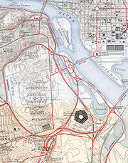
State Route 27 is a freeway in Arlington County
, Virginia, in the United States. It was built during World War II
to connect the Pentagon
with U.S. Route 50
(US 50) and northern Arlington to the west and Washington, DC, to the east. Its 2.54 miles (4.1 km) route parallels the southern boundaries of Arlington National Cemetery. At its southernmost point, Route 27 passes through a complex interchange with Interstate 395 (I-395, Shirley Highway
). called the "Mixing Bowl
," although local motorists more recently use that term also to refer to the Springfield Interchange
on the Capital Beltway
in Springfield
. It is an important commuter route and well as providing access to a number of military installations, the cemetery and national memorials. Because Route 27 is the closest road to the site of the September 11 attack on the Pentagon, the route has been designated the "9/11 Heroes Memorial Highway."
east and south of US 50 (Arlington Boulevard
). From US 50, Route 27 has two interchanges with Route 244
(Columbia Pike) on either side of the Mixing Bowl Route 27 runs northwest-to-southeast on the west side of the Mixing Bowl and runs southwest-to-northeast on the east side of the Mixing Bowl. It is a limited-access, four- or six–lane divided highway for its entire length.
More specifically, Route 27 begins in an interchange with US 50. Route 27 has an interchange with 2nd Street South, which serves as an entrance to Fort Myer
. The first interchange with Route 244 offers a very short merge area because of the proximity to the exit ramps to I-395 and Arlington Ridge Road.
East of the Mixing Bowl, Route 27 runs past the Pentagon (with a second interchange for Route 244) in the direction of the George Washington Memorial Parkway
and the Arlington Memorial Bridge
, ending at the Boundary Channel
, which is the border with the District of Columbia. Route 27 is part of the National Highway System
with the portion west of the Mixing Bowl designated as part of the Strategic Highway Network and the part east of the Mixing Bowl designated an arterial highway.
On the segment west of the Mixing Bowl, Route 27 has an interchange with 2nd Street South, which serves as an entrance to Fort Myer
. The first interchange with Route 244 offers a very short merge area because of the proximity to the exit ramps to I-395 and Arlington Ridge Road. The Mixing Bowl is the first interchange in Northern Virginia with a three level bridge—ramp from I-395 to westbound Route 27 on the lowest level, eastbound Route 27 to Mixing Bowl in the middle; and southbound I-395 on top. In 1970 this was followed by a second three level stack—Joyce Street South on the lowest level, eastbound Route 27 on the middle bridge and I-395 on the top level.
At this point, Route 27 becomes a part of the collector lanes and ramps of the Mixing Bowl until its second interchange with Route 244. Also, coincident with the second Route 244 interchange, Route 27 is the northern terminus of the reversible high occupancy vehicle lanes of I-395. The westbound entrance to these lanes have a series of manually closed barriers to prevent an accidental oncoming collision during the hours each day when traffic flows to the east on the HOV lanes. The final interchange in Virginia accesses Route 110, the Pentagon North Parking Lot and Boundary Channel Drive. Although the ramp from eastbound Route 27 to northbound Route 110 is open to the public, it is on the Pentagon Reservation and is patrolled by the Pentagon Police.
Route 27 is closed for large events held at the Pentagon including the annual Marine Corps Marathon
and the Army Ten-Miler
. A number of points of interest are visible from the highway, including (from west to east) Fort Myer
(which was the site of the first military test flight), Henderson Hall (the headquarters of the United States Marine Corps
), the United States Air Force Memorial
, the Pentagon
, the Navy Annex, the Pentagon Memorial
, the Pentagon City Mall, and Arlington National Cemetery
.
 The road was constructed as a part of the Pentagon Road Network
during World War II
to provide access to the newly constructed War Department headquarters buildings. The system included three cloverleaf interchange
s which were "among the earliest such structures constructed in the United States." Those roads were transferred to the Virginia Department of Highways on December 17, 1964, and assigned the number Route 27. However, at that time, the Mixing Bowl included a ramp from the westbound Shirley Highway to the eastbound Route 27. When the high-occupancy vehicle lanes were added to I-395 in the 1970s, the Mixing Bowl was reconfigured so that the Route 27 lanes were separated as collector lanes from the through lanes of I-395. Because the collector lanes were built on the site of the ramp from westbound Shirley Highway to the eastbound Route 27, the ramp was replaced with a ramp from the eastbound Route 27 into the Pentagon South Parking Lot.
The Mixing Bowl is the first interchange in Northern Virginia with a three level bridge—ramp from I-395 to westbound Route 27 on the lowest level, eastbound Route 27 to Mixing Bowl in the middle; and southbound I-395 on top. In 1970 this was followed by a second three-level stack—Joyce Street South on the lowest level, eastbound Route 27 on the middle bridge and I-395 on the top level.
Route 27 is near the site of the September 11 attacks on the Pentagon. Many commuters and drivers on the road witnessed the hijacked American Airlines Flight 77
fly directly over Route 27 and crash into the Pentagon. Witnesses included Daryl Donley and Steve Riskus, both of whom took some of the first photographs after the plane crashed. As the plane passed over Route 27, it clipped several light poles; one light pole landed on the windshield of a taxicab
driven by Lloyd England. The section northeast of I-395 was closed for several weeks following the attack as a security measure. When it reopened, "No stopping" signs were placed along the section of Route 27 near the Pentagon. To increase security, the cloverleaf interchange between Route 27 and Columbia Pike was reconfigured, by eliminating the separate loop ramp from eastbound Route 27 to westbound Columbia Pike. The ramp from westbound Columbia Pike to eastbound Route 27 was relocated parallel to Route 27 and the resulting freed area was used to construct a security checkpoint leading to a new Pentagon loading dock. A driveway from the checkpoint runs parallel to Route 27 separated by a high metal fence. However, the Pentagon Memorial
still remains visible behind this fence. North of the memorial, a high cement retaining wall and berm has been constructed to protect the Pentagon from any possible explosion threats on Route 27. These and related security improvements cost $35 million (equivalent to $ in ) and were completed in October 2004. On September 11, 2010, the portion of Route 27 near the crash site was dedicated as "9/11 Heroes Memorial Highway" after receiving that designation by the State Legislature. Commemorative signs have been added on both sides of the highway.
In 2001, planning began for a replacement of the US 50 bridge over Route 27, which had been built in 1944 by the War Department. Construction of a replacement bridge began in October 2005 and ended in August 2007. The project cost $6.5 million (equivalent to $ in ). At 3:40 a.m. on December 22, 2004, a gasoline tank truck
overturned and exploded on Washington Boulevard at the Mixing Bowl, near the Pentagon. The accident killed the driver, and sparked initial concerns that this explosion was another terrorist
attack. The driver was headed to a nearby gas station, near the Pentagon.
, Virginia.
Arlington County, Virginia
Arlington County is a county in the Commonwealth of Virginia. The land that became Arlington was originally donated by Virginia to the United States government to form part of the new federal capital district. On February 27, 1801, the United States Congress organized the area as a subdivision of...
, Virginia, in the United States. It was built during World War II
World War II
World War II, or the Second World War , was a global conflict lasting from 1939 to 1945, involving most of the world's nations—including all of the great powers—eventually forming two opposing military alliances: the Allies and the Axis...
to connect the Pentagon
The Pentagon
The Pentagon is the headquarters of the United States Department of Defense, located in Arlington County, Virginia. As a symbol of the U.S. military, "the Pentagon" is often used metonymically to refer to the Department of Defense rather than the building itself.Designed by the American architect...
with U.S. Route 50
U.S. Route 50 in Virginia
U.S. Route 50 is a transcontinental highway which stretches from Ocean City, Maryland to Sacramento, California. In the U.S. state of Virginia, US 50 extends from the border with Washington DC at a Potomac River crossing at Rosslyn in Arlington County to the West Virginia state line near Gore in...
(US 50) and northern Arlington to the west and Washington, DC, to the east. Its 2.54 miles (4.1 km) route parallels the southern boundaries of Arlington National Cemetery. At its southernmost point, Route 27 passes through a complex interchange with Interstate 395 (I-395, Shirley Highway
Henry G. Shirley Memorial Highway
The Henry G. Shirley Memorial Highway consists of a portion of Interstates 95 and 395 in the U.S. state of Virginia. Shirley Highway was the first limited-access freeway in Virginia...
). called the "Mixing Bowl
Pentagon road network
The Pentagon road network is a system of highways, mostly freeways, built by the United States federal government in the early 1940s to serve the Pentagon in northern Virginia. The roads, transferred to the Commonwealth of Virginia in 1964, are now state highways...
," although local motorists more recently use that term also to refer to the Springfield Interchange
Springfield Interchange
The Springfield Interchange, also known as the Mixing Bowl, is the interchange of Interstate 95, Interstate 395, and Interstate 495 in Springfield, Virginia, outside of Washington, D.C....
on the Capital Beltway
Interstate 495 (Capital Beltway)
Interstate 495 is a Interstate Highway that surrounds the United States' capital of Washington, D.C., and its inner suburbs in adjacent Maryland and Virginia. I-495 is widely known as the Capital Beltway or simply the Beltway, especially when the context of Washington, D.C., is clear...
in Springfield
Springfield, Virginia
Springfield is a census-designated place in Fairfax County, Virginia, United States and a suburb of Washington, D.C. The Springfield CDP is recognized by the U.S. Census Bureau with a population of 30,484 as of the 2010 census. Homes and businesses in bordering CDPs including North Springfield,...
. It is an important commuter route and well as providing access to a number of military installations, the cemetery and national memorials. Because Route 27 is the closest road to the site of the September 11 attack on the Pentagon, the route has been designated the "9/11 Heroes Memorial Highway."
Route description
Route 27 is the portion of Washington BoulevardWashington Boulevard (Arlington)
Washington Boulevard is a road in Arlington County, Virginia. It begins as a highway, connecting the George Washington Memorial Parkway and Arlington Memorial Bridge with Interstate 395, running past The Pentagon and Arlington National Cemetery...
east and south of US 50 (Arlington Boulevard
Arlington Boulevard
Arlington Boulevard is a major arterial road in Arlington County, Fairfax County, and the independent City of Fairfax in Northern Virginia in metropolitan Washington, DC, United States. It is designated U.S...
). From US 50, Route 27 has two interchanges with Route 244
Virginia State Route 244
State Route 244, also known as Columbia Pike, is a primary state highway in the U.S. state of Virginia. It is a four-lane road that runs from State Route 236 in Annandale, Fairfax County east to State Route 27 at the Pentagon in Arlington County.-History:Columbia Pike dates to 1810 when the U.S...
(Columbia Pike) on either side of the Mixing Bowl Route 27 runs northwest-to-southeast on the west side of the Mixing Bowl and runs southwest-to-northeast on the east side of the Mixing Bowl. It is a limited-access, four- or six–lane divided highway for its entire length.
More specifically, Route 27 begins in an interchange with US 50. Route 27 has an interchange with 2nd Street South, which serves as an entrance to Fort Myer
Fort Myer
Fort Myer is a U.S. Army post adjacent to Arlington National Cemetery in Arlington County, Virginia, across the Potomac River from Washington, D.C. It is a small post by U.S...
. The first interchange with Route 244 offers a very short merge area because of the proximity to the exit ramps to I-395 and Arlington Ridge Road.
East of the Mixing Bowl, Route 27 runs past the Pentagon (with a second interchange for Route 244) in the direction of the George Washington Memorial Parkway
George Washington Memorial Parkway
The George Washington Memorial Parkway, known to local motorists simply as the "G.W. Parkway", is a parkway maintained by the U.S. National Park Service. It is located mostly in Northern Virginia, although a short section northwest of the Arlington Memorial Bridge passes over Columbia Island,...
and the Arlington Memorial Bridge
Arlington Memorial Bridge
The Arlington Memorial Bridge in Washington, D.C. crosses the Potomac River, connecting the Lincoln Memorial and Columbia Island. The northeastern end of the bridge marks the western edge of the National Mall...
, ending at the Boundary Channel
Boundary Channel
Boundary Channel is a channel off the Potomac River in Washington, D.C. The channel extends southward from the Potomac between Columbia Island to the east and the Virginia shore to the west and ends at the Pentagon Lagoon. Boundary Channel is shallow and is crossed by several fixed...
, which is the border with the District of Columbia. Route 27 is part of the National Highway System
National Highway System (United States)
The National Highway System is a network of strategic highways within the United States, including the Interstate Highway System and other roads serving major airports, ports, rail or truck terminals, railway stations, pipeline terminals and other strategic transport facilities.Individual states...
with the portion west of the Mixing Bowl designated as part of the Strategic Highway Network and the part east of the Mixing Bowl designated an arterial highway.
On the segment west of the Mixing Bowl, Route 27 has an interchange with 2nd Street South, which serves as an entrance to Fort Myer
Fort Myer
Fort Myer is a U.S. Army post adjacent to Arlington National Cemetery in Arlington County, Virginia, across the Potomac River from Washington, D.C. It is a small post by U.S...
. The first interchange with Route 244 offers a very short merge area because of the proximity to the exit ramps to I-395 and Arlington Ridge Road. The Mixing Bowl is the first interchange in Northern Virginia with a three level bridge—ramp from I-395 to westbound Route 27 on the lowest level, eastbound Route 27 to Mixing Bowl in the middle; and southbound I-395 on top. In 1970 this was followed by a second three level stack—Joyce Street South on the lowest level, eastbound Route 27 on the middle bridge and I-395 on the top level.
At this point, Route 27 becomes a part of the collector lanes and ramps of the Mixing Bowl until its second interchange with Route 244. Also, coincident with the second Route 244 interchange, Route 27 is the northern terminus of the reversible high occupancy vehicle lanes of I-395. The westbound entrance to these lanes have a series of manually closed barriers to prevent an accidental oncoming collision during the hours each day when traffic flows to the east on the HOV lanes. The final interchange in Virginia accesses Route 110, the Pentagon North Parking Lot and Boundary Channel Drive. Although the ramp from eastbound Route 27 to northbound Route 110 is open to the public, it is on the Pentagon Reservation and is patrolled by the Pentagon Police.
Route 27 is closed for large events held at the Pentagon including the annual Marine Corps Marathon
Marine Corps Marathon
The Marine Corps Marathon is an annual marathon held in Arlington, Virginia and Washington, DC. The mission of the MCM is to promote physical fitness, generate community goodwill and showcase the organizational skills of the United States Marine Corps....
and the Army Ten-Miler
Army Ten-Miler
The Army Ten-Miler is America's largest ten-mile race, held every October in Washington, DC and sponsored by the U.S. Army Military District of Washington....
. A number of points of interest are visible from the highway, including (from west to east) Fort Myer
Fort Myer
Fort Myer is a U.S. Army post adjacent to Arlington National Cemetery in Arlington County, Virginia, across the Potomac River from Washington, D.C. It is a small post by U.S...
(which was the site of the first military test flight), Henderson Hall (the headquarters of the United States Marine Corps
United States Marine Corps
The United States Marine Corps is a branch of the United States Armed Forces responsible for providing power projection from the sea, using the mobility of the United States Navy to deliver combined-arms task forces rapidly. It is one of seven uniformed services of the United States...
), the United States Air Force Memorial
United States Air Force Memorial
The United States Air Force Memorial honors the service of the personnel of the United States Air Force and its predecessors. The Memorial is located in Arlington, Virginia, on the grounds of Fort Myer near The Pentagon and Arlington National Cemetery, at the intersection of Columbia Pike and...
, the Pentagon
The Pentagon
The Pentagon is the headquarters of the United States Department of Defense, located in Arlington County, Virginia. As a symbol of the U.S. military, "the Pentagon" is often used metonymically to refer to the Department of Defense rather than the building itself.Designed by the American architect...
, the Navy Annex, the Pentagon Memorial
Pentagon Memorial
The Pentagon Memorial, located just southwest of The Pentagon in Arlington County, Virginia, is a permanent outdoor memorial to the 184 men and women who lost their lives as victims of the attack, killed both in the building and on American Airlines Flight 77 in the September 11, 2001...
, the Pentagon City Mall, and Arlington National Cemetery
Arlington National Cemetery
Arlington National Cemetery in Arlington County, Virginia, is a military cemetery in the United States of America, established during the American Civil War on the grounds of Arlington House, formerly the estate of the family of Confederate general Robert E. Lee's wife Mary Anna Lee, a great...
.
History
Pentagon road network
The Pentagon road network is a system of highways, mostly freeways, built by the United States federal government in the early 1940s to serve the Pentagon in northern Virginia. The roads, transferred to the Commonwealth of Virginia in 1964, are now state highways...
during World War II
World War II
World War II, or the Second World War , was a global conflict lasting from 1939 to 1945, involving most of the world's nations—including all of the great powers—eventually forming two opposing military alliances: the Allies and the Axis...
to provide access to the newly constructed War Department headquarters buildings. The system included three cloverleaf interchange
Cloverleaf interchange
A cloverleaf interchange is a two-level interchange in which left turns, reverse direction in left-driving regions, are handled by ramp roads...
s which were "among the earliest such structures constructed in the United States." Those roads were transferred to the Virginia Department of Highways on December 17, 1964, and assigned the number Route 27. However, at that time, the Mixing Bowl included a ramp from the westbound Shirley Highway to the eastbound Route 27. When the high-occupancy vehicle lanes were added to I-395 in the 1970s, the Mixing Bowl was reconfigured so that the Route 27 lanes were separated as collector lanes from the through lanes of I-395. Because the collector lanes were built on the site of the ramp from westbound Shirley Highway to the eastbound Route 27, the ramp was replaced with a ramp from the eastbound Route 27 into the Pentagon South Parking Lot.
The Mixing Bowl is the first interchange in Northern Virginia with a three level bridge—ramp from I-395 to westbound Route 27 on the lowest level, eastbound Route 27 to Mixing Bowl in the middle; and southbound I-395 on top. In 1970 this was followed by a second three-level stack—Joyce Street South on the lowest level, eastbound Route 27 on the middle bridge and I-395 on the top level.
Route 27 is near the site of the September 11 attacks on the Pentagon. Many commuters and drivers on the road witnessed the hijacked American Airlines Flight 77
American Airlines Flight 77
American Airlines Flight 77 was American Airlines' daily scheduled morning transcontinental flight, from Washington Dulles International Airport, in Dulles, Virginia to Los Angeles International Airport in Los Angeles, California...
fly directly over Route 27 and crash into the Pentagon. Witnesses included Daryl Donley and Steve Riskus, both of whom took some of the first photographs after the plane crashed. As the plane passed over Route 27, it clipped several light poles; one light pole landed on the windshield of a taxicab
Taxicab
A taxicab, also taxi or cab, is a type of vehicle for hire with a driver, used by a single passenger or small group of passengers, often for a non-shared ride. A taxicab conveys passengers between locations of their choice...
driven by Lloyd England. The section northeast of I-395 was closed for several weeks following the attack as a security measure. When it reopened, "No stopping" signs were placed along the section of Route 27 near the Pentagon. To increase security, the cloverleaf interchange between Route 27 and Columbia Pike was reconfigured, by eliminating the separate loop ramp from eastbound Route 27 to westbound Columbia Pike. The ramp from westbound Columbia Pike to eastbound Route 27 was relocated parallel to Route 27 and the resulting freed area was used to construct a security checkpoint leading to a new Pentagon loading dock. A driveway from the checkpoint runs parallel to Route 27 separated by a high metal fence. However, the Pentagon Memorial
Pentagon Memorial
The Pentagon Memorial, located just southwest of The Pentagon in Arlington County, Virginia, is a permanent outdoor memorial to the 184 men and women who lost their lives as victims of the attack, killed both in the building and on American Airlines Flight 77 in the September 11, 2001...
still remains visible behind this fence. North of the memorial, a high cement retaining wall and berm has been constructed to protect the Pentagon from any possible explosion threats on Route 27. These and related security improvements cost $35 million (equivalent to $ in ) and were completed in October 2004. On September 11, 2010, the portion of Route 27 near the crash site was dedicated as "9/11 Heroes Memorial Highway" after receiving that designation by the State Legislature. Commemorative signs have been added on both sides of the highway.
In 2001, planning began for a replacement of the US 50 bridge over Route 27, which had been built in 1944 by the War Department. Construction of a replacement bridge began in October 2005 and ended in August 2007. The project cost $6.5 million (equivalent to $ in ). At 3:40 a.m. on December 22, 2004, a gasoline tank truck
Tank truck
A tank truck or road tanker is a motor vehicle designed to carry liquefied loads, dry bulk cargo or gases on roads. The largest such vehicles are similar to railroad tank cars which are also designed to carry liquefied loads...
overturned and exploded on Washington Boulevard at the Mixing Bowl, near the Pentagon. The accident killed the driver, and sparked initial concerns that this explosion was another terrorist
Terrorism
Terrorism is the systematic use of terror, especially as a means of coercion. In the international community, however, terrorism has no universally agreed, legally binding, criminal law definition...
attack. The driver was headed to a nearby gas station, near the Pentagon.
Future plans
The bridge over Columbia Pike west of the Mixing Bowl has been rated as "poor" and a new replacement bridge has been proposed with a reconfiguration of the interchange. If funds are available, construction is expected to begin in 2012 and completed in 2015.Exit list
The entire route is in Arlington CountyArlington County, Virginia
Arlington County is a county in the Commonwealth of Virginia. The land that became Arlington was originally donated by Virginia to the United States government to form part of the new federal capital district. On February 27, 1801, the United States Congress organized the area as a subdivision of...
, Virginia.