
Villa La Angostura
Encyclopedia
Villa La Angostura is a village in the south of the Argentine
province
of Neuquén
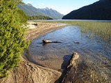
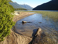
, on the northwest shore of the Nahuel Huapi Lake
.
and Bariloche, inside the Nahuel Huapi National Park
, very close to the isthmus of the Quetrihue Peninsula, where the Los Arrayanes National Park
and its arrayan
es (Luma apiculata) forest is located. The town is located nearby Cardenal Antonio Samoré Pass
that links it with Osorno
in Chile
.
The elevation of the city centre is about 790 m, the lake is at 765 m. Surrounding mountains range from 1,500 m to about 2,000 m (Cerro Bayo, right behind the city, is 1,782 m high).
The area's micro-climate offers relatively mild temperatures though winter covers it in snow. Summers are known for being sunny and pleasant, with high temperatures usually between 18°C and 25°C, but with cold nights between 2°C and 9°C. Temperatures will reach 30°C only a couple of times every year, and night frost happens occasionally during the summer as well. There are often long stretches of sunny, windy weather; however, when the weather gets locked in a stormy pattern, it can remain so for several days or weeks: temperatures will stay cold (10°C to 18°C) and summer sleet is not unprecedented. Rainfall in the summer averages 70 mm to 85 mm per month, with a very high variability from one year to another.
March brings more frequent frost, but also nice stretches of sunny weather. The average high temperature is 19°C, the low is 4°C, occasionally 30°C can be reached, and temperatures may fall to -5°C. The most radical change occurs sometime during the month of April, when Villa La Angostura first gets in the path of a "train of Pacific storms": in the end, total precipitation for the month averages 168 mm. The average high is 14°C, the low is 2°C (the nighttime change is small due to increased cloudiness)and by late April any cloudless night will be frosty.
May is known for being extremely rainy, with an average amount of 434 mm (including sleet and snow). It is also often the month of the first significant snowfall. High temperatures are usually around 9°C or 10°C, lows average 1°C, sometimes temperatures can reach -10°C. June, July and August are the core of the winter in Villa La Angostura, when the average high ranges from 5°C to 8°C and lows from 0°C to -2°C. Storms are very frequent and usually bring a mixture of rain, snow and sleet; overall precipitation averages 200 mm to 300 mm monthly for the period, falling mostly as snow in the mountains around the city. Snowstorms can sometimes be heavy (over 20 cm), and extreme cold waves might bring temperatures down to -18°C or lower; however, long stretches of intense frost are rare as Pacific storms always strike the area with milder, moist air.
In September, the storminess diminishes slightly (172 mm in total), and high temperatures reach an average of 11°C, although low temperatures only increase to -1°C. By the end of the month, there might be stretches of pleasant weather and comfortable temperatures, but the month also marks the beginning of the windiest part of the year.
October is extremely variable, going back and forth between periods of extremely windy, but sunny weather, and freak cold snaps that bring night temperatures below -5°C and mixtures of sleet and snow. Average highs are 14°C, lows are 1°C, and precipitation reaches 121 mm. November brings springlike weather, much lower precipitation (83 mm) but strong winds and wild variations in temperature. Averages are 17°C in the afternoon and 3°C at night, but it is not unusual to have a day of rain and sleet with a high below 5°C, or a day with sunny weather and a high of 25°C. Finally, December is a transition between spring and summer: winds are still very strong and freak variations occur, but the average high of 20°C and the low of 5°C are more typical of summer weather. Storminess might be a bit higher as in November, with an average of 90 mm of rain.
On the whole, Villa La Angostura's climate is noted for being among the rainiest in Argentina (with 2,074 mm of rain over almost 300 days a year), for having no frost-free periods whatsoever, and for its clear, dry and extremely pleasant summer days. Areas west of the city are much rainier, with over 3,000 mm over Brazo Rincon.
Nearby La Angostura is the Cerro Bayo
and its ski centre. The resort's base, at only 250 m higher than the city, usually only sees sufficient snow cover for a few weeks in midwinter, following large storms. However, slopes above the altitude of 1,200 m offer reliable snow cover, and most of the skiing takes place between 1,500 m and 1,780 m, where pockets of snow might be found till midsummer. The view from the top is impressive, especially toward the west, across Nahuel Huapi lake, with the majestic, heavily glaciated Cerro Tronador (3,450 m), clearly visible.
 La Angostura is considered among the main attractions of Argentina's Andean
Patagonia
not only because of the wooden town itself, but also because of the beauty of its sights. On its west side is the Nahuel Huapi Lake, and to the east, the Correntoso Lake.
Both lakes are connected by the Correntoso River, which, with 200 meters of length, is one of the sport fishing destinations around La Angostura.
The architecture of the town follows a stylized Alpine
wooden style similar to that of Bariloche's city centre.
There are shops and restaurants of artisanal products such as chocolate, beer
and trout
. It's categorised as a mountain village, even though it has approximately 11,000 inhabitants.
Argentina
Argentina , officially the Argentine Republic , is the second largest country in South America by land area, after Brazil. It is constituted as a federation of 23 provinces and an autonomous city, Buenos Aires...
province
Provinces of Argentina
Argentina is subdivided into twenty-three provinces and one autonomous city...
of Neuquén
Neuquén Province
Neuquén is a province of Argentina, located in the west of the country, at the northern end of Patagonia. It borders Mendoza Province to the north, Rio Negro Province to the southeast, and Chile to the west...
, on the northwest shore of the Nahuel Huapi Lake
Nahuel Huapi Lake
Nahuel Huapi Lake is a lake in the lake region of northern Patagonia between the provinces of Río Negro and Neuquén, in Argentina. The lake depression consists of several glacial valleys carved out along faults and Miocene valleys that were later dammed by moraines.Nahuel Huapi lake, located...
.
Geography and climate
The village is located halfway between the cities of San Martín de los AndesSan Martín de los Andes
-References:* - Official website.-External links:*...
and Bariloche, inside the Nahuel Huapi National Park
Nahuel Huapi National Park
Established in 1934, the Nahuel Huapi National Park is the oldest national park in Argentina. It surrounds Nahuel Huapi Lake in the foothills of the Patagonian Andes. The largest of the national parks in the region, it has an area of , or nearly 2 million acres...
, very close to the isthmus of the Quetrihue Peninsula, where the Los Arrayanes National Park
Los Arrayanes National Park
Los Arrayanes National Park is a national park of Argentina with an area of 17.53 square kilometres. It covers the Quetrihué Peninsula on the shore of the Nahuel Huapi Lake in the province of Neuquén, 3 km from Villa la Angostura....
and its arrayan
Luma apiculata
Luma apiculata, is a species of tree in the genus Luma in the family Myrtaceae, native to the central Andes mountains between Chile and Argentina between 33 and 45° South Latitude. Synonyms include Myrtus luma Mol., Eugenia apiculata DC., Myrceugenia apiculata Niedenzu, and Myrceugenella...
es (Luma apiculata) forest is located. The town is located nearby Cardenal Antonio Samoré Pass
Cardenal Antonio Samoré Pass
Cardenal Antonio Samoré Pass it is one of the main mountain pass through the southern Andes along the border between Argentina and Chile.Together with Paso Libertadores, it is one of the easiest of the Argentina-Chile passes, and one of the few with asphalted roads in the region...
that links it with Osorno
Osorno, Chile
Osorno is a city and commune in southern Chile and capital of Osorno Province in the Los Lagos Region. It had a population of 145,475, as of the 2002 census...
in Chile
Chile
Chile ,officially the Republic of Chile , is a country in South America occupying a long, narrow coastal strip between the Andes mountains to the east and the Pacific Ocean to the west. It borders Peru to the north, Bolivia to the northeast, Argentina to the east, and the Drake Passage in the far...
.
The elevation of the city centre is about 790 m, the lake is at 765 m. Surrounding mountains range from 1,500 m to about 2,000 m (Cerro Bayo, right behind the city, is 1,782 m high).
The area's micro-climate offers relatively mild temperatures though winter covers it in snow. Summers are known for being sunny and pleasant, with high temperatures usually between 18°C and 25°C, but with cold nights between 2°C and 9°C. Temperatures will reach 30°C only a couple of times every year, and night frost happens occasionally during the summer as well. There are often long stretches of sunny, windy weather; however, when the weather gets locked in a stormy pattern, it can remain so for several days or weeks: temperatures will stay cold (10°C to 18°C) and summer sleet is not unprecedented. Rainfall in the summer averages 70 mm to 85 mm per month, with a very high variability from one year to another.
March brings more frequent frost, but also nice stretches of sunny weather. The average high temperature is 19°C, the low is 4°C, occasionally 30°C can be reached, and temperatures may fall to -5°C. The most radical change occurs sometime during the month of April, when Villa La Angostura first gets in the path of a "train of Pacific storms": in the end, total precipitation for the month averages 168 mm. The average high is 14°C, the low is 2°C (the nighttime change is small due to increased cloudiness)and by late April any cloudless night will be frosty.
May is known for being extremely rainy, with an average amount of 434 mm (including sleet and snow). It is also often the month of the first significant snowfall. High temperatures are usually around 9°C or 10°C, lows average 1°C, sometimes temperatures can reach -10°C. June, July and August are the core of the winter in Villa La Angostura, when the average high ranges from 5°C to 8°C and lows from 0°C to -2°C. Storms are very frequent and usually bring a mixture of rain, snow and sleet; overall precipitation averages 200 mm to 300 mm monthly for the period, falling mostly as snow in the mountains around the city. Snowstorms can sometimes be heavy (over 20 cm), and extreme cold waves might bring temperatures down to -18°C or lower; however, long stretches of intense frost are rare as Pacific storms always strike the area with milder, moist air.
In September, the storminess diminishes slightly (172 mm in total), and high temperatures reach an average of 11°C, although low temperatures only increase to -1°C. By the end of the month, there might be stretches of pleasant weather and comfortable temperatures, but the month also marks the beginning of the windiest part of the year.
October is extremely variable, going back and forth between periods of extremely windy, but sunny weather, and freak cold snaps that bring night temperatures below -5°C and mixtures of sleet and snow. Average highs are 14°C, lows are 1°C, and precipitation reaches 121 mm. November brings springlike weather, much lower precipitation (83 mm) but strong winds and wild variations in temperature. Averages are 17°C in the afternoon and 3°C at night, but it is not unusual to have a day of rain and sleet with a high below 5°C, or a day with sunny weather and a high of 25°C. Finally, December is a transition between spring and summer: winds are still very strong and freak variations occur, but the average high of 20°C and the low of 5°C are more typical of summer weather. Storminess might be a bit higher as in November, with an average of 90 mm of rain.
On the whole, Villa La Angostura's climate is noted for being among the rainiest in Argentina (with 2,074 mm of rain over almost 300 days a year), for having no frost-free periods whatsoever, and for its clear, dry and extremely pleasant summer days. Areas west of the city are much rainier, with over 3,000 mm over Brazo Rincon.
Nearby La Angostura is the Cerro Bayo
Cerro Bayo
Cerro Bayo is a complex volcano on the northern part border between Argentina and Chile. It consists of four overlapping stratovolcanoes along a north-south line...
and its ski centre. The resort's base, at only 250 m higher than the city, usually only sees sufficient snow cover for a few weeks in midwinter, following large storms. However, slopes above the altitude of 1,200 m offer reliable snow cover, and most of the skiing takes place between 1,500 m and 1,780 m, where pockets of snow might be found till midsummer. The view from the top is impressive, especially toward the west, across Nahuel Huapi lake, with the majestic, heavily glaciated Cerro Tronador (3,450 m), clearly visible.
Tourism
Andes
The Andes is the world's longest continental mountain range. It is a continual range of highlands along the western coast of South America. This range is about long, about to wide , and of an average height of about .Along its length, the Andes is split into several ranges, which are separated...
Patagonia
Patagonia
Patagonia is a region located in Argentina and Chile, integrating the southernmost section of the Andes mountains to the southwest towards the Pacific ocean and from the east of the cordillera to the valleys it follows south through Colorado River towards Carmen de Patagones in the Atlantic Ocean...
not only because of the wooden town itself, but also because of the beauty of its sights. On its west side is the Nahuel Huapi Lake, and to the east, the Correntoso Lake.
Both lakes are connected by the Correntoso River, which, with 200 meters of length, is one of the sport fishing destinations around La Angostura.
The architecture of the town follows a stylized Alpine
Alpine
The term alpine refers to the Alps, a European mountain range.Alpine may also refer to:- Geography and geology :* Alpine tundra, the biological community that occurs above the tree line at high altitude...
wooden style similar to that of Bariloche's city centre.
There are shops and restaurants of artisanal products such as chocolate, beer
Beer
Beer is the world's most widely consumed andprobably oldest alcoholic beverage; it is the third most popular drink overall, after water and tea. It is produced by the brewing and fermentation of sugars, mainly derived from malted cereal grains, most commonly malted barley and malted wheat...
and trout
Trout
Trout is the name for a number of species of freshwater and saltwater fish belonging to the Salmoninae subfamily of the family Salmonidae. Salmon belong to the same family as trout. Most salmon species spend almost all their lives in salt water...
. It's categorised as a mountain village, even though it has approximately 11,000 inhabitants.
2011 Volcanic Ash
In June 2011, Villa La Angostura was declared a disaster area due to the massive layer ash dumped on the community by the eruption to the west in Chile.External links
- Tourist / Accommodation Guide of Villa La Angostura
- Villa La Angustura at welcomeArgentina.com
- History, pictures and maps (Spanish)
- Villa La Angostura area (Spanish)
- Hotels in Villa La Angostura
- Tourist information site
- Villa La Angostura Web (Spanish)
- Tourist Guide Villa La Angostura Patagonia Argentina Hystory, Tourism Information, Activities, Ski, Accommodation, Gastronomy, Services Photos(Spanish, Portuguese, English)
- Weather for Villa la Angostura . (Spanish)
- Villa La Angostura Accommodation Guide (English)