
Vila Pouca de Aguiar
Encyclopedia
Vila Pouca de Aguiar (ˈvilɐ ˈpowkɐ ðɨ ɐɣiˈaɾ) is a municipality in northern Portugal
with an area of 437.07 km², and population of approximately 14837 inhabitants (its municipal seat has 3,456 residents). Integrated into the Alto Tâmega subregion, the municipality of Vila Pouca de Aguiar is situated in the north of the district of Vila Real
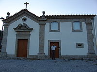
, between the mountains of Serra do Alvão and Serra da Padrela, extending over a territory of approximately 437 km². It is located within a strategic connection, not just between other Portuguese municipalities in the interior but also, as a transit point to the coastal areas (across the A7 and A24 motorways). Within a long fertile valley, and surrounded by high pasture-lands, it is defensively safe within the Transmontana escarpments. The region is covered in national monuments and historical structures: the Castle of Aguiar da Pena, the millenarian Roman mining complex of Tresminas, the thermals of Pedras Salgadas, several leisure centres (such as the Falperra Dam/Reservoir), the Dolmens of Alvão, churches, graves/funeral sites, medieval bridges, sun-dials and castro
dot the landscape of this unassuming region.
 The origin of Vila Pouca da Aguiar has caused differing opinions. Some authors hypothesis that "Vila Pouca" was the successor to the ancient city of "Cauca", which was governed by Emperor Theodosius I
. Yet, this theory can not explain the name transition from Cauca to Pouca. Another belief is that "Vila Pouca" was a reference to a small agrarian community, and that "Aguiar" was a reference to an ancient administrative region. The name was, therefore, most likely, a phrase to disambiguate all the other communities named "Vila Pouca". Literally, the name means "Vila Pouca OF Aguiar", wherein etymologically, "aguiar" derived from the word aquila to designate "where the eagles are" (águia is ).
In the 13th century, the municipality of Vila Pouca de Aguiar was part of the land of Aguiar, much like other such as sites, like the Ribeira de Pena (or ). In the 12 and 13th century, Aguiar was constituted by seven grande ecclesiastical parishes, which included São Salvador de Jugal, which corresponded to the actual parish of Vila Pouca de Aguiar. The Inquirições (inquiries/inventory) of King Afonso II
established that the parochia of São Salvador de Jugal was composed of the localities and towns: Condado (three couples); Calvos (one couple); Guilhado (four couples) and Nuzedo (20 couples), in addition to the towns of Fraengo and Outeiro. The document also identifies Jugal as an administrative unit, with elaborated administrative domain over the territory of Aguiar, and where the parochial church was located, but no reference to Jugal as a town.
There is no indication as to the motives for changing the name from São Salvador de Jugal to Vila Pouca, nor the date, although it likely occurred sometime in the 14th century.
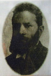
In the early 20th century, the leading figure in the area was Martiniano José Ferreira Botelho, a doctor, druggist and politician, known from his humanitarian character and support of the use of the local medicinal waters for treatments The Botelhos donated land to the community for the current market square, as well as the municipal slaughter house and well.
In 2006 the A7 toll road to Guimarães
was completed and the last stretch of the A24, connecting Vila Pouca with Vila Real
was opened in June 2007. This non-toll four-lane highway links Coimbra with the Spanish border in Vila Verde. One of the longest and highest highway bridges in Europe was built just south of Vila Pouca, carrying traffic across the fertile valley.
The municipality is composed of 18 parishes, and is located in the district of Vila Real
:
Vila Pouca de Aguiar has for many years experienced the desertification of the Portuguese interior. Population densities have historically identified a strong concentration of people in the municipal seat, or its peripheral parishes. From 1981 to 1991, the parishes of Bragado, Pensalves, Afonsim, Vreia de Jales, Vreia de Bornes, Valoura and Soutelo de Aguiar have registered flawing population growth rates. The parish of Sabroso de Aguiar did not exist in 1981, but by 1991 it registered the highest population concentration in the region. Comparatively, between 1991 and 2001, there were no changes in population densities in many of the parishes. The municipal seat and Sabroso de Aguiar continue to show a growth in population density.
with: Fabero del Bierzo, El Bierzo
, Province of León, Spain
In addition, the economy supports small service industries, government-based dominated teritary employment, the granite extraction industry (concentrated in the mines of Jales) and the mineral waters in Pedras Salgadas
, a small spa town located about ten kilometers north on the main highway to Chaves.
Portugal
Portugal , officially the Portuguese Republic is a country situated in southwestern Europe on the Iberian Peninsula. Portugal is the westernmost country of Europe, and is bordered by the Atlantic Ocean to the West and South and by Spain to the North and East. The Atlantic archipelagos of the...
with an area of 437.07 km², and population of approximately 14837 inhabitants (its municipal seat has 3,456 residents). Integrated into the Alto Tâmega subregion, the municipality of Vila Pouca de Aguiar is situated in the north of the district of Vila Real
Vila Real (district)
The District of Vila Real is a district of northern Portugal. With an area of 4,239 km², the district is located west of the port city of Porto and north of the Douro River. Vila Real has always belonged to the historical province of Tras-os-Montes. Approximate population in the 2001...
, between the mountains of Serra do Alvão and Serra da Padrela, extending over a territory of approximately 437 km². It is located within a strategic connection, not just between other Portuguese municipalities in the interior but also, as a transit point to the coastal areas (across the A7 and A24 motorways). Within a long fertile valley, and surrounded by high pasture-lands, it is defensively safe within the Transmontana escarpments. The region is covered in national monuments and historical structures: the Castle of Aguiar da Pena, the millenarian Roman mining complex of Tresminas, the thermals of Pedras Salgadas, several leisure centres (such as the Falperra Dam/Reservoir), the Dolmens of Alvão, churches, graves/funeral sites, medieval bridges, sun-dials and castro
Castro culture
Castro culture is the archaeological term for naming the Celtic archaeological culture of the northwestern regions of the Iberian Peninsula from the end of the Bronze Age until it was subsumed in local Roman culture...
dot the landscape of this unassuming region.
History
Theodosius I
Theodosius I , also known as Theodosius the Great, was Roman Emperor from 379 to 395. Theodosius was the last emperor to rule over both the eastern and the western halves of the Roman Empire. During his reign, the Goths secured control of Illyricum after the Gothic War, establishing their homeland...
. Yet, this theory can not explain the name transition from Cauca to Pouca. Another belief is that "Vila Pouca" was a reference to a small agrarian community, and that "Aguiar" was a reference to an ancient administrative region. The name was, therefore, most likely, a phrase to disambiguate all the other communities named "Vila Pouca". Literally, the name means "Vila Pouca OF Aguiar", wherein etymologically, "aguiar" derived from the word aquila to designate "where the eagles are" (águia is ).
In the 13th century, the municipality of Vila Pouca de Aguiar was part of the land of Aguiar, much like other such as sites, like the Ribeira de Pena (or ). In the 12 and 13th century, Aguiar was constituted by seven grande ecclesiastical parishes, which included São Salvador de Jugal, which corresponded to the actual parish of Vila Pouca de Aguiar. The Inquirições (inquiries/inventory) of King Afonso II
Afonso II of Portugal
Afonso II , or Affonso , Alfonso or Alphonso or Alphonsus , nicknamed "the Fat" , third king of Portugal, was born in Coimbra on 23 April 1185 and died on 25 March 1223 in the same city. He was the second but eldest surviving son of Sancho I of Portugal by his wife, Dulce, Infanta of Aragon...
established that the parochia of São Salvador de Jugal was composed of the localities and towns: Condado (three couples); Calvos (one couple); Guilhado (four couples) and Nuzedo (20 couples), in addition to the towns of Fraengo and Outeiro. The document also identifies Jugal as an administrative unit, with elaborated administrative domain over the territory of Aguiar, and where the parochial church was located, but no reference to Jugal as a town.
There is no indication as to the motives for changing the name from São Salvador de Jugal to Vila Pouca, nor the date, although it likely occurred sometime in the 14th century.
In the early 20th century, the leading figure in the area was Martiniano José Ferreira Botelho, a doctor, druggist and politician, known from his humanitarian character and support of the use of the local medicinal waters for treatments The Botelhos donated land to the community for the current market square, as well as the municipal slaughter house and well.
Geography
It is located in a narrow valley 25 kilometers north of the district capital, Vila Real, and is connected to the same by national N2 highway.In 2006 the A7 toll road to Guimarães
Guimarães
Guimarães Municipality is located in northwestern Portugal in the province of Minho and in the Braga District. It contains the city of Guimarães.The present Mayor is António Magalhães Silva, elected by the Socialist Party.-Parishes:-Economy:...
was completed and the last stretch of the A24, connecting Vila Pouca with Vila Real
Vila Real, Portugal
Vila Real is a city in Vila Real Municipality, Trás-os-Montes, northern Portugal.According to the 2001 census, the city had a total of 24,481 inhabitants.- History :...
was opened in June 2007. This non-toll four-lane highway links Coimbra with the Spanish border in Vila Verde. One of the longest and highest highway bridges in Europe was built just south of Vila Pouca, carrying traffic across the fertile valley.
The municipality is composed of 18 parishes, and is located in the district of Vila Real
Vila Real (district)
The District of Vila Real is a district of northern Portugal. With an area of 4,239 km², the district is located west of the port city of Porto and north of the Douro River. Vila Real has always belonged to the historical province of Tras-os-Montes. Approximate population in the 2001...
:
|
|
Vila Pouca de Aguiar has for many years experienced the desertification of the Portuguese interior. Population densities have historically identified a strong concentration of people in the municipal seat, or its peripheral parishes. From 1981 to 1991, the parishes of Bragado, Pensalves, Afonsim, Vreia de Jales, Vreia de Bornes, Valoura and Soutelo de Aguiar have registered flawing population growth rates. The parish of Sabroso de Aguiar did not exist in 1981, but by 1991 it registered the highest population concentration in the region. Comparatively, between 1991 and 2001, there were no changes in population densities in many of the parishes. The municipal seat and Sabroso de Aguiar continue to show a growth in population density.
Twin towns — Sister cities
Vila Pouca de Aguiar is twinnedTown twinning
Twin towns and sister cities are two of many terms used to describe the cooperative agreements between towns, cities, and even counties in geographically and politically distinct areas to promote cultural and commercial ties.- Terminology :...
with: Fabero del Bierzo, El Bierzo
El Bierzo
El Bierzo is a shire in the province of León, Spain. The valley has the administrative status of comarca and its capital is the town of Ponferrada. Other major towns are Bembibre and Villafranca del Bierzo, the historical capital.- History :...
, Province of León, Spain
Spain
Spain , officially the Kingdom of Spain languages]] under the European Charter for Regional or Minority Languages. In each of these, Spain's official name is as follows:;;;;;;), is a country and member state of the European Union located in southwestern Europe on the Iberian Peninsula...
Economy
Part of region characterized by fertile soils, and the typical climate of the Terra Fria Transmontana, the municipality of Vila Pouca de Aguiar is essentially subsistence agricultural, cultivating cereal crops, potato, vegetables and supporting some vineyards. The small valleys support cattle which graze in the open pasturelands. The lands of the Alvão valley benefited from the construction of the Alvão Dam/Reservoir, which allowed irrigation of these lands since the mid-20th century.In addition, the economy supports small service industries, government-based dominated teritary employment, the granite extraction industry (concentrated in the mines of Jales) and the mineral waters in Pedras Salgadas
Pedras Salgadas
Pedras Salgadas is a small spa town in the district of Vila Real, in north central Portugal, located approximately 37 km north of the district capital of Vila Real. It is famous for its mineral waters. There are several small hotels in the area, which cater to tourists who want to relax in...
, a small spa town located about ten kilometers north on the main highway to Chaves.
Notable citizens
- Martiniano José Ferreira Botelho (c.1853 – c.1939), a doctor, druggist, politician and humanitarian, known for his local service to the community and his treatise on the medicinal use of the waters of the area, "Breve estudo sobre as águas alcalino-gazósas das Pedras Salgadas". His home is a point of reference in the community, known as the Casa do Condado (House of the CountyHouse of the CountyThe House of the County or Casa do Condado is since 2007 the museum of Vila Pouca de Aguiar in Portugal. It includes a collection of cultural goods constituted by archaeological and ethnographic materials of great value from the region....
).