

Vessels of the Lakes Route
Encyclopedia
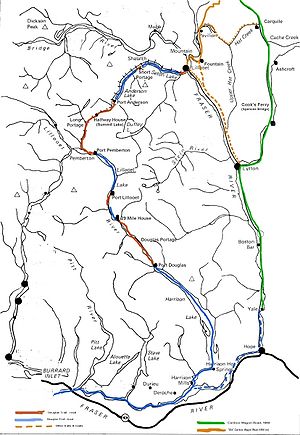
Douglas Road
The Douglas Road, aka the Lillooet Trail, Harrison Trail or Lakes Route, was a goldrush-era transportation route from the British Columbia Coast to the Interior...
, which was the first formally-designated "road" into the Interior of British Columbia
British Columbia
British Columbia is the westernmost of Canada's provinces and is known for its natural beauty, as reflected in its Latin motto, Splendor sine occasu . Its name was chosen by Queen Victoria in 1858...
, Canada
Canada
Canada is a North American country consisting of ten provinces and three territories. Located in the northern part of the continent, it extends from the Atlantic Ocean in the east to the Pacific Ocean in the west, and northward into the Arctic Ocean...
from its Lower Mainland
Lower Mainland
The Lower Mainland is a name commonly applied to the region surrounding and including Vancouver, British Columbia, Canada. As of 2007, 2,524,113 people live in the region; sixteen of the province's thirty most populous municipalities are located there.While the term Lower Mainland has been...
area flanking the Lower Fraser River. Also known as the Douglas-Lillooet Trail or the Lillooet Trail (not to be confused with the Lillooet Cattle Trail
Lillooet Cattle Trail
The Lillooet Cattle Trail, also known as the Lillooet-Burrard Cattle Trail and also as the Lillooet Trail , was an unusual and daring public works undertaking by the Province of British Columbia in the 1877, and was the largest 19th Century public works expenditure at $35,000 of the new province...
, also called the Lillooet Trail), the route consisted of a series of wagon roads connected via lake travel in between. A variety of craft were use on the lakes, from steamboats to sail-driven rafts to, through the early 20th Century, diesel and other engines. Lake travel continued for commerce, passenger travel and heavy freight until after World War II.
There were originally four lakes on the route, in addition to Harrison Lake at the road's commencement at Port Douglas
Port Douglas, British Columbia
Port Douglas, sometimes referred to simply as Douglas, is a remote community in British Columbia, Canada at the head of Harrison Lake, which is the head of river navigation from the Strait of Georgia...
, which is navigable from the Lower Fraser and so also from the Gulf of Georgia and Victoria
Victoria, British Columbia
Victoria is the capital city of British Columbia, Canada and is located on the southern tip of Vancouver Island off Canada's Pacific coast. The city has a population of about 78,000 within the metropolitan area of Greater Victoria, which has a population of 360,063, the 15th most populous Canadian...
and beyond. These were Little Lillooet Lake (Tenas Lake - "tenas" means "small" or "child" in the Chinook Jargon
Chinook Jargon
Chinook Jargon originated as a pidgin trade language of the Pacific Northwest, and spread during the 19th century from the lower Columbia River, first to other areas in modern Oregon and Washington, then British Columbia and as far as Alaska, sometimes taking on characteristics of a creole language...
, a name also used for Birken Lake
Birken Lake
Gates Lake, also known as Birken Lake, Tenass Lake, Halfway Lake, and Summit Lake, is a small lake located at the summit of the Pemberton Portage area of the one-time Lakes Route through the Coast Mountains, located at the summit of a low pass connecting the Upper and Lower Lillooet Country of the...
which also lies along the route), Lillooet Lake, Anderson Lake and Seton Lake, the foot of which is within a few miles of the Fraser River at today's town of Lillooet (until 1860 called Cayoosh Flat or Cayoosh) and from where the last few miles of wagon road completed the official Douglas Road. From there the Old Cariboo Road
Old Cariboo Road
The Old Cariboo Road is a reference to the original wagon road to the Cariboo gold fields in what is now the Canadian province of British Columbia...
was constructed by entrepreneur Gustavus Blin Wright
Gustavus Blin Wright
Gustavus Blin Wright was a pioneer roadbuilder and entrepreneur in British Columbia, Canada. His biggest achievement was building the Old Cariboo Road to the Cariboo gold fields, from Lillooet to Fort Alexandria, but he was also a partner in a freighting firm that operated on the Douglas Road, he...
to Alexandria in order to serve the booming traffic to the Cariboo and points northwards. The combination of the Douglas Road and Blin-Wright's toll road were the main route north for freight and travel (excepting the River Trail
River Trail (British Columbia)
The River Trail was a main route for travel in the colonial era of what is now the Canadian province of British Columbia, running northwards along the Fraser River from to present day Lillooet to Big Bar, British Columbia and points beyond in the Cariboo District...
which was for packhorses, mules and foot only) and so the Douglas Road and its various vessels saw a huge amount of traffic, though declining rapidly once the Cariboo Road
Cariboo Road
The Cariboo Road was a project initiated in 1860 by the colonial Governor of British Columbia, James Douglas...
from Yale via Ashcroft was opened in 1864 (the critical section from Yale to the existing older road at Clinton, which bypassed Port Douglas, Douglas Road and Lillooet entirely, being completed by about 1863) after which the route fell into decline. Continued needs by the communities in the isolated Pemberton and Gates Valleys, which were dependent on Lillooet for most services and on either Lillooet or the old sea-access from Port Douglas meant that for many years passenger and freight services continued on a smaller scale, particularly on Seton and Anderson Lakes. The boom in the Bridge River goldfields from the 1890s and the transportation of heavy equipment into the mines required barge transport, and the construction of the Pacific Great Eastern Railway along the north shores of these lakes also involved their own small flotilla of construction-related craft. Later, when development of the Bridge River Project
Bridge River Power Project
The Bridge River Power Project is a hydroelectric power development in the Canadian province of British Columbia, located in the Lillooet Country between Whistler and Lillooet...
swung into full gear after World War II, hydro construction also required lake transport, although rail service was largely preferred.
Little Lillooet Lake was raised slightly by the Royal Engineers in their improvements to the route, turning it into a lower arm of Lillooet Lake, obliterating the need for the short portage to Lillooet Lake and moving the southern port on that lake - originally called Port Lillooet - down to what had been the south end of Little Lillooet Lake.
Vessels on Little Lillooet and Lillooet Lakes
- SS Prince of Wales
- SS Prince Lee Boo
Vessels on Seton Lake
- MV Champion
- Minne-ha-ha
- Bluebird
- Marshall's Ferry
See also
- Steamboats of the Arrow LakesSteamboats of the Arrow LakesThe era of steamboats on the Arrow Lakes and adjoining reaches of the Columbia River is long-gone but was an important part of the history of the West Kootenay and Columbia Country regions of British Columbia. The Arrow Lakes are formed by the Columbia River in southeastern British Columbia...
- Steamboats of Lake OkanaganSteamboats of Lake OkanaganLake Okanagan, also called Okanagan Lake, is the largest lake in the Okanogan River drainage, which is tributary to the Columbia River basin, and is the core of the Okanagan region of British Columbia, Canada. During its early days of settlement and development, lack of roads the region made the...
- Steamboats of the Upper Fraser River in British ColumbiaSteamboats of the Upper Fraser River in British ColumbiaTwelve paddlewheel steamboats plied the upper Fraser River in British Columbia from 1863 until 1921. They were used for a variety of purposes: working on railroad construction, delivering mail, promoting real estate in infant townsites and bringing settlers in to a new frontier. They served the...
- Steamboats of the Skeena RiverSteamboats of the Skeena RiverThe Skeena River is British Columbia’s fastest flowing waterway, often rising as much as in a day and can fluctuate as much as sixty feet between high and low water. For the steamboat captains, that made it one of the toughest navigable rivers in British Columbia...
- Steamboats of the upper Columbia and Kootenay RiversSteamboats of the upper Columbia and Kootenay RiversFrom 1886 to 1920, steamboats ran on the upper reaches of the Columbia and Kootenay in the Rocky Mountain Trench, in western North America. The circumstances of the rivers in the area, and the construction of transcontinental railways across the trench from east to west made steamboat navigation...
- Steamboats of the Yukon RiverSteamboats of the Yukon RiverSteamboats played a huge role on the development of Alaska and the Yukon. Access to the interior of Alaska and Yukon was hindered by large mountains and distance, the wide Yukon River provided a solution. The first steamers on the lower Yukon River were work boats for the Collins Overland Telegraph...