

Cariboo Road
Encyclopedia
The Cariboo Road was a project initiated in 1860 by the colonial Governor of British Columbia
, James Douglas
. It was a feat of engineering stretching from Fort Yale
to Barkerville
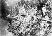
through extremely hazardous canyon territory in the Interior of B.C.
Between the 1860s and the 1880s the Cariboo Road existed in three versions as a surveyed and constructed wagon road route. The first Cariboo Wagon Road surveyed in 1861 and built in 1862 followed the original Hudson's Bay Company
's Harrison Trail (Port Douglas
) route from Lillooet
to Clinton
, 70 Mile House, 100 Mile House, Lac La Hache, 150 Mile House to the contract end around Soda Creek
and Alexandria
at the doorstep of the Cariboo Gold Fields. The second Cariboo Wagon Road (or Yale Cariboo Road) operated during the period of the fast stage coaches and freight wagon companies headquartered in Yale
: 1865 to 1885. From the water landing at Yale
, the road followed north via the spectacular Fraser Canyon
route over Hell's Gate and Jackass Mountain
and connecting to the earlier Cariboo Road at Clinton
. The third Cariboo Road was the revised route following the completion of the Canadian Pacific Railway
in 1885. The railway station at Ashcroft became the southern end of the wagon road. Much of the Fraser Canyon
wagon road was destroyed by the railway construction as well as by washouts and the Great Flood of 1894 (interest in rebuilding this portion of the road would not occur until the construction plans for the Fraser Canyon Highway for automobiles in the 1920s).
 The road was a reaction to the high concentration of gold in the Cariboo
region and the dangerous "mule trail", which was a rough-hewn cliff-side trail wide enough only for one mule that ran along the approximate route of the Cariboo Road. In order to lower supply costs to the settlers in the Cariboo region, Douglas ordered the construction of a more viable and safe form of transportation to the gold mining settlements. The colonial government employed locals as well as a detachment of the Royal Engineers
("sappers") who undertook amazing engineering feats including construction of toll bridges including the (original) Alexandra Suspension Bridge of 1863.
Building the road cost nearly one and a quarter million dollars, and left a standing debt of £112,780 after its completion, one of many infrastructure costs in servicing the Gold Colony that forced its amalgamation first with Vancouver Island (1866), and then with Canada (1871 confederation). The Cariboo Road saw the transportation of over six and a half million dollars worth of gold. Originally Douglas wanted to stretch the road across the continental divide into Rupert's Land
(modern day Alberta
) but this plan was abandoned when Douglas retired in 1864.
, Van Winkle and on to Williams Creek
(Richfield, Barkerville). This route was known also as the Old Cariboo Road
, when the Lakes Route from Port Douglas
to Lillooet
had not yet been superseded by the Fraser Canyon route of the Cariboo Wagon Road proper. The mile-house names (e.g. 100 Mile House), in the Cariboo are derived from measurements taken from the Mile '0' of this road, which is in the bend in the Main Street of Lillooet and commemorated there by a cairn erected in the 1958 Centennial Year. It was along this route that an attempt was made to use Bactrian camels
purchased from the U.S. Camel Corps for freight (1862), and also a tractor-style Thomson Road Steamer known as a "road train", one of the earliest motorized vehicles.
Most foot traffic from Lillooet to the Cariboo however, went by the "River Trail
", far below the wagon road, which departed the Fraser Canyon at Pavilion
for the steep climb over Pavilion Mountain to Clinton
, where it merged with the newer Cariboo Road via Yale and Ashcroft (once the latter route was completed, that is). The River Trail continued along the Fraser Canyon as far as Big Bar and various routes spread towards Quesnel and Barkerville from there.
British Columbia
British Columbia is the westernmost of Canada's provinces and is known for its natural beauty, as reflected in its Latin motto, Splendor sine occasu . Its name was chosen by Queen Victoria in 1858...
, James Douglas
James Douglas (Governor)
Sir James Douglas KCB was a company fur-trader and a British colonial governor on Vancouver Island in northwestern North America, particularly in what is now British Columbia. Douglas worked for the North West Company, and later for the Hudson's Bay Company becoming a high-ranking company officer...
. It was a feat of engineering stretching from Fort Yale
Yale, British Columbia
Yale is an unincorporated town in the Canadian province of British Columbia. It was founded in 1848 by the Hudson's Bay Company as Fort Yale by Ovid Allard, the appointed manager of the new post, who named it after his superior, James Murray Yale, then Chief Factor of the Columbia District...
to Barkerville
Barkerville, British Columbia
Barkerville was the main town of the Cariboo Gold Rush in British Columbia, Canada and is preserved as a historic town. It is located on the north slope of the Cariboo Plateau near the Cariboo Mountains east of Quesnel along BC Highway 26, which follows the route of the original access to...
through extremely hazardous canyon territory in the Interior of B.C.
Between the 1860s and the 1880s the Cariboo Road existed in three versions as a surveyed and constructed wagon road route. The first Cariboo Wagon Road surveyed in 1861 and built in 1862 followed the original Hudson's Bay Company
Hudson's Bay Company
The Hudson's Bay Company , abbreviated HBC, or "The Bay" is the oldest commercial corporation in North America and one of the oldest in the world. A fur trading business for much of its existence, today Hudson's Bay Company owns and operates retail stores throughout Canada...
's Harrison Trail (Port Douglas
Port Douglas, British Columbia
Port Douglas, sometimes referred to simply as Douglas, is a remote community in British Columbia, Canada at the head of Harrison Lake, which is the head of river navigation from the Strait of Georgia...
) route from Lillooet
Lillooet
Lillooet may refer to:*Lillooet, a town in the Fraser Canyon in British Columbia.*the St'at'imc people, also known as the Lillooet people*The Lillooet language, also known under the names of its dialects St'at'imcets and Ucwalmícwts...
to Clinton
Clinton, British Columbia
Clinton is a village in British Columbia, Canada, located approximately 40 km northwest of Cache Creek and 30 km south of 70 Mile House.It is considered by some to straddle the southern edge of the Cariboo country of British Columbia, although others consider Ashcroft-Cache Creek, Lillooet, Savona,...
, 70 Mile House, 100 Mile House, Lac La Hache, 150 Mile House to the contract end around Soda Creek
Soda Creek
Soda Creek is a rural subdivision 38 km north of Williams Lakein British Columbia, Canada. Located on the east bank of the Fraser River, Soda Creek was originally the home of the Xat'sull First Nation. Soda Creek Indian Reserve No. 1 is located on the left bank of the Fraser River, one mile...
and Alexandria
Alexandria, British Columbia
Alexandria or Fort Alexandria is a National Historic Site of Canada on the Fraser River in British Columbia, and was the end of the Old Cariboo Road and the Cariboo Wagon Road...
at the doorstep of the Cariboo Gold Fields. The second Cariboo Wagon Road (or Yale Cariboo Road) operated during the period of the fast stage coaches and freight wagon companies headquartered in Yale
Yale, British Columbia
Yale is an unincorporated town in the Canadian province of British Columbia. It was founded in 1848 by the Hudson's Bay Company as Fort Yale by Ovid Allard, the appointed manager of the new post, who named it after his superior, James Murray Yale, then Chief Factor of the Columbia District...
: 1865 to 1885. From the water landing at Yale
Yale, British Columbia
Yale is an unincorporated town in the Canadian province of British Columbia. It was founded in 1848 by the Hudson's Bay Company as Fort Yale by Ovid Allard, the appointed manager of the new post, who named it after his superior, James Murray Yale, then Chief Factor of the Columbia District...
, the road followed north via the spectacular Fraser Canyon
Fraser Canyon
The Fraser Canyon is an 84 km landform of the Fraser River where it descends rapidly through narrow rock gorges in the Coast Mountains en route from the Interior Plateau of British Columbia to the Fraser Valley...
route over Hell's Gate and Jackass Mountain
Jackass Mountain
Jackass Mountain is a mountain in the Canadian Cascades of the Cascade Range in southwestern British Columbia, Canada, located southeast of Lytton and south of Mount Lytton. It is named for the muletrains that ventured north to the Cariboo gold fields; apparentlysome did not make it over the...
and connecting to the earlier Cariboo Road at Clinton
Clinton
Clinton is an English family name, indicating one's ancestors came from English places called Glympton or Glinton. Clinton has frequently been used as a given name in the United States since the late 19th century, probably originally in honor of DeWitt Clinton or one of his famous relatives...
. The third Cariboo Road was the revised route following the completion of the Canadian Pacific Railway
Canadian Pacific Railway
The Canadian Pacific Railway , formerly also known as CP Rail between 1968 and 1996, is a historic Canadian Class I railway founded in 1881 and now operated by Canadian Pacific Railway Limited, which began operations as legal owner in a corporate restructuring in 2001...
in 1885. The railway station at Ashcroft became the southern end of the wagon road. Much of the Fraser Canyon
Fraser Canyon
The Fraser Canyon is an 84 km landform of the Fraser River where it descends rapidly through narrow rock gorges in the Coast Mountains en route from the Interior Plateau of British Columbia to the Fraser Valley...
wagon road was destroyed by the railway construction as well as by washouts and the Great Flood of 1894 (interest in rebuilding this portion of the road would not occur until the construction plans for the Fraser Canyon Highway for automobiles in the 1920s).
Cariboo
The Cariboo is an intermontane region of British Columbia along a plateau stretching from the Fraser Canyon to the Cariboo Mountains. The name is a reference to the woodland caribou that were once abundant in the region...
region and the dangerous "mule trail", which was a rough-hewn cliff-side trail wide enough only for one mule that ran along the approximate route of the Cariboo Road. In order to lower supply costs to the settlers in the Cariboo region, Douglas ordered the construction of a more viable and safe form of transportation to the gold mining settlements. The colonial government employed locals as well as a detachment of the Royal Engineers
Royal Engineers
The Corps of Royal Engineers, usually just called the Royal Engineers , and commonly known as the Sappers, is one of the corps of the British Army....
("sappers") who undertook amazing engineering feats including construction of toll bridges including the (original) Alexandra Suspension Bridge of 1863.
Building the road cost nearly one and a quarter million dollars, and left a standing debt of £112,780 after its completion, one of many infrastructure costs in servicing the Gold Colony that forced its amalgamation first with Vancouver Island (1866), and then with Canada (1871 confederation). The Cariboo Road saw the transportation of over six and a half million dollars worth of gold. Originally Douglas wanted to stretch the road across the continental divide into Rupert's Land
Rupert's Land
Rupert's Land, or Prince Rupert's Land, was a territory in British North America, consisting of the Hudson Bay drainage basin that was nominally owned by the Hudson's Bay Company for 200 years from 1670 to 1870, although numerous aboriginal groups lived in the same territory and disputed the...
(modern day Alberta
Alberta
Alberta is a province of Canada. It had an estimated population of 3.7 million in 2010 making it the most populous of Canada's three prairie provinces...
) but this plan was abandoned when Douglas retired in 1864.
The "Old" Cariboo Road
The name Cariboo Road or Cariboo Trail is also informally applied to a toll road built by contractor Gustavus Blin-Wright in 1861–1862 from Lillooet to Williams LakeWilliams Lake, British Columbia
Williams Lake, is a city in the Central Interior of British Columbia, Canada. Located in the central part of a region known as the Cariboo, it is the largest urban centre between Kamloops and Prince George, with a population of 11,150 in city limits....
, Van Winkle and on to Williams Creek
Williams Creek (British Columbia)
Williams Creek is an important historical gold mining creek in the Cariboo goldfields of the Central Interior of British Columbia, entering the Willow River between Barkerville and the town of Wells, which is at the headwaters of the Willow River....
(Richfield, Barkerville). This route was known also as the Old Cariboo Road
Old Cariboo Road
The Old Cariboo Road is a reference to the original wagon road to the Cariboo gold fields in what is now the Canadian province of British Columbia...
, when the Lakes Route from Port Douglas
Port Douglas, British Columbia
Port Douglas, sometimes referred to simply as Douglas, is a remote community in British Columbia, Canada at the head of Harrison Lake, which is the head of river navigation from the Strait of Georgia...
to Lillooet
Lillooet, British Columbia
Lillooet is a community on the Fraser River in western Canada, about up the British Columbia Railway line from Vancouver. Situated at an intersection of deep gorges in the lee of the Coast Mountains, it has a dry climate- of precipitation is recorded annually at the town's weather station,...
had not yet been superseded by the Fraser Canyon route of the Cariboo Wagon Road proper. The mile-house names (e.g. 100 Mile House), in the Cariboo are derived from measurements taken from the Mile '0' of this road, which is in the bend in the Main Street of Lillooet and commemorated there by a cairn erected in the 1958 Centennial Year. It was along this route that an attempt was made to use Bactrian camels
Bactrian camel
The Bactrian camel is a large, even-toed ungulate native to the steppes of central Asia. It is presently restricted in the wild to remote regions of the Gobi and Taklamakan Deserts of Mongolia and Xinjiang. A small number of wild Bactrian camels still roam the Mangystau Province of southwest...
purchased from the U.S. Camel Corps for freight (1862), and also a tractor-style Thomson Road Steamer known as a "road train", one of the earliest motorized vehicles.
Most foot traffic from Lillooet to the Cariboo however, went by the "River Trail
River Trail (British Columbia)
The River Trail was a main route for travel in the colonial era of what is now the Canadian province of British Columbia, running northwards along the Fraser River from to present day Lillooet to Big Bar, British Columbia and points beyond in the Cariboo District...
", far below the wagon road, which departed the Fraser Canyon at Pavilion
Pavilion, British Columbia
Pavilion is a ranching and Indian Reserve community in the Fraser Canyon area of British Columbia, Canada. Most of the community is the population of the Pavilion 1 Indian Reserve of the Pavilion Indian Band, aka the Ts'kw'aylaxw First Nation but there are also a number of ranches in the...
for the steep climb over Pavilion Mountain to Clinton
Clinton, British Columbia
Clinton is a village in British Columbia, Canada, located approximately 40 km northwest of Cache Creek and 30 km south of 70 Mile House.It is considered by some to straddle the southern edge of the Cariboo country of British Columbia, although others consider Ashcroft-Cache Creek, Lillooet, Savona,...
, where it merged with the newer Cariboo Road via Yale and Ashcroft (once the latter route was completed, that is). The River Trail continued along the Fraser Canyon as far as Big Bar and various routes spread towards Quesnel and Barkerville from there.
See also
- Fraser Canyon Gold RushFraser Canyon Gold RushThe Fraser Canyon Gold Rush, began in 1858 after gold was discovered on the Thompson River in British Columbia at its confluence with the Nicoamen River. This was a few miles upstream from the Thompson's confluence with the Fraser River at present-day Lytton...
- Whatcom TrailWhatcom TrailThe Whatcom Trail was an overland trail from the Puget Sound area of Washington Territory during the Fraser Canyon Gold Rush of 1858. Named for the then-chief of the Nooksack people on Bellingham Bay, where the trail began at Fairhaven , the route used went via a route known as the Columbia...
- Okanagan TrailOkanagan TrailThe Okanagan Trail was an inland route to the Fraser Canyon Gold Rush from the Lower Columbia region of the Washington and Oregon Territories in 1858-1859...
- Dewdney TrailThe Dewdney TrailThe Dewdney Trail is a trail in British Columbia, Canada that served as a major thoroughfare in mid-19th century British Columbia. The trail was a critical factor in the development and strengthening of the newly established British Colony of British Columbia, tying together mining camps and small...
- Lillooet Cattle TrailLillooet Cattle TrailThe Lillooet Cattle Trail, also known as the Lillooet-Burrard Cattle Trail and also as the Lillooet Trail , was an unusual and daring public works undertaking by the Province of British Columbia in the 1877, and was the largest 19th Century public works expenditure at $35,000 of the new province...
(Lillooet Road, North Vancouver) - Cariboo Highway
- Old Cariboo HighwayOld Cariboo HighwayThe Old Cariboo Highway is a portion of the historic Cariboo Highway near Prince George, British Columbia. It runs northward from its junction with Highway 97 just south of Prince George, and terminates at the Yellowhead Highway just east of Prince George....
Further reading
- Downs, Art. Wagon Road North. NW Dispatch, 1960.
- Harris, Lorraine. Fraser Canyon: From Cariboo Road to Super Highway. Hancock House, 1984.
- Paternaude, Branwen. Trails to Gold. Horsdahl and Schubert. 1995.
- Wells, Martin. Steam to the Cariboo. Cordillera, 2009.