

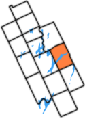
Verulam Township, Ontario
Encyclopedia
Municipality
A municipality is essentially an urban administrative division having corporate status and usually powers of self-government. It can also be used to mean the governing body of a municipality. A municipality is a general-purpose administrative subdivision, as opposed to a special-purpose district...
within the former Victoria County
Victoria County, Ontario
The County of Victoria, or Victoria County, was a county in the Canadian province of Ontario. It was formed in 1854 as The United Counties of Peterborough and Victoria, and gained independence in 1863. In 2001, the county was dissolved and reformed as the city of Kawartha Lakes...
, now the city of Kawartha Lakes
Kawartha Lakes
The city of Kawartha Lakes is a unitary municipality in Central Ontario, Canada. Although called a city, Kawartha Lakes is the size of a typical Ontarian county and is mostly rural....
. It was bounded on the north by the geographic township of Somerville, the south by the geographic township of Emily, the west by the geographic township of Fenelon, and the east by the County of Peterborough
Peterborough County, Ontario
Peterborough County is located in Southern Ontario, Canada. It is projected to reach a population of 159,840 by 2031, according to the Ontario Ministry of Finance's Ontario Population Projections Update...
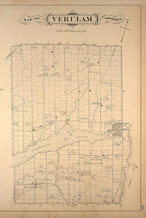
. For the purposes of government, land suryeying and reference, it is now properly referred to as the "Geographic Township of Verulam".
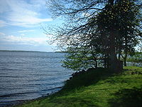
The township was ten concessions (each ⅞ mile wide) and thirty-two lots deep, and was surveyed on the Lake Ontario frontage system. Sturgeon Lake
Sturgeon Lake (Ontario)
Sturgeon Lake is a lake in the Kawartha Lakes region of Ontario, Canada. It is part of the Trent-Severn Waterway. The lake is Y shaped and has the communities of Fenelon Falls, Lindsay, Sturgeon Point and Bobcaygeon at the north-west, south, central and north-east points of the Y respectively...
completely bisected the township from west to east.
Errors in surveying across the lake resulted in jogs in many of lot lines north of the lake in Concessions IV through X, and was the cause of the irregular northern boundary. The township also included parts of Concession XIX of the Geographic Township of Harvey which were isolated from the rest of that township by Pigeon Lake in the east.
The Township of Verulam was part of Peterborough County
Peterborough County, Ontario
Peterborough County is located in Southern Ontario, Canada. It is projected to reach a population of 159,840 by 2031, according to the Ontario Ministry of Finance's Ontario Population Projections Update...
until 1850, when Victoria County
Victoria County, Ontario
The County of Victoria, or Victoria County, was a county in the Canadian province of Ontario. It was formed in 1854 as The United Counties of Peterborough and Victoria, and gained independence in 1863. In 2001, the county was dissolved and reformed as the city of Kawartha Lakes...
was formed. It is now part of the city of Kawartha Lakes.
Communities
- BobcaygeonBobcaygeon, OntarioBobcaygeon is a community on the Trent-Severn Waterway in the City of Kawartha Lakes, east-central Ontario, Canada.Bobcaygeon was incorporated as village in 1876, and became known as the "Hub of the Kawarthas"...
, former township seat - Ancona Point
- Dunsford
- Greenhurst-Thurstonia
- Kenstone Beach
- Red Rock
- Sturgeon Point
History
Mississaugas
The Mississaugas are a subtribe of the Anishinaabe-speaking First Nations people located in southern Ontario, Canada. They are closely related to the Ojibwa...
met at Port Hope
Port Hope, Ontario
Port Hope is a municipality in Southern Ontario, Canada, about east of Toronto and about west of Kingston. It is located at the mouth of the Ganaraska River on the north shore of Lake Ontario, in the west end of Northumberland County...
to sign a treaty to convey to the Crown
The Crown
The Crown is a corporation sole that in the Commonwealth realms and any provincial or state sub-divisions thereof represents the legal embodiment of governance, whether executive, legislative, or judicial...
all the land which is now City of Kawartha Lakes and Peterborough County
Peterborough County, Ontario
Peterborough County is located in Southern Ontario, Canada. It is projected to reach a population of 159,840 by 2031, according to the Ontario Ministry of Finance's Ontario Population Projections Update...
for the sum of about ₤740.
Verulam Township was named for the Earl Of Verulam, James Walter Grimston (1775 - 1845) who was the brother-in-law of Lord Liverpool, Prime Minister of the United Kingdom
Prime Minister of the United Kingdom
The Prime Minister of the United Kingdom of Great Britain and Northern Ireland is the Head of Her Majesty's Government in the United Kingdom. The Prime Minister and Cabinet are collectively accountable for their policies and actions to the Sovereign, to Parliament, to their political party and...
from 1812 to 1827. The township was surveyed in 1831 by the government of Upper Canada
Upper Canada
The Province of Upper Canada was a political division in British Canada established in 1791 by the British Empire to govern the central third of the lands in British North America and to accommodate Loyalist refugees from the United States of America after the American Revolution...
and lots were first offered for sale in 1832, for 8 shillings per acre.
Agriculture
Lumbering was the first important industry to be developed, as the township had abundant stands of white pine up until about 1904, when loggers moved northward into HaliburtonHaliburton County, Ontario
Haliburton is a county of Ontario, Canada, known as a tourist and cottage area in Central Ontario for its scenery and for its resident artists. Minden Hills is the county seat. Haliburton County was established in 1983, but had existed as the Provisional County of Haliburton since 1874...
and what is now Algonquin Park. Agriculture in various forms was also pursued with the land south of the lake most suitable for crops. Dairying is still an important industry with Kawartha Dairy Company
Kawartha Dairy Company
Kawartha Dairy Company is a Canadian family owned and operated dairy based in Bobcaygeon, Ontario in the City of Kawartha Lakes. The company was founded in 1937, and is run by two brothers and the son of a brother who died....
, the last large remaining dairy in the area serving south central Ontario, is in operation at Bobcaygeon. The Verulam Agricultural Society founded in 1858, still meets and holds an annual Fall Fair at its Fairgrounds located on the main island of Bobcaygeon.
Settlement
Settlement first occurred at BobcaygeonBobcaygeon, Ontario
Bobcaygeon is a community on the Trent-Severn Waterway in the City of Kawartha Lakes, east-central Ontario, Canada.Bobcaygeon was incorporated as village in 1876, and became known as the "Hub of the Kawarthas"...
, at the eastern end of the township with the 1832 arrival of Thomas Need from England
England
England is a country that is part of the United Kingdom. It shares land borders with Scotland to the north and Wales to the west; the Irish Sea is to the north west, the Celtic Sea to the south west, with the North Sea to the east and the English Channel to the south separating it from continental...
. Thomas Need built a lumber and grist mill, laid out a village plot, founded a Post Office
Canada Post
Canada Post Corporation, known more simply as Canada Post , is the Canadian crown corporation which functions as the country's primary postal operator...
, and supervised the building of the first lock on the Trent-Severn Waterway
Trent-Severn Waterway
The Trent–Severn Waterway is a Canadian canal system formerly used for industrial and transportation purposes and now for recreational and tourism purposes, connecting Lake Ontario at Trenton to the Georgian Bay portion of Lake Huron at Port Severn...
. Several other notable settlements arose over the years, including the hamlet of Dunsford, the Police village
Police village
A police village was a form of municipal government used in the province of Ontario, Canada, beginning in the early 19th century. It was used in cases where the finances or population of the area did not permit the creation of a village....
of Greenhurst-Thurstonia, and the Police village
Police village
A police village was a form of municipal government used in the province of Ontario, Canada, beginning in the early 19th century. It was used in cases where the finances or population of the area did not permit the creation of a village....
of Sturgeon Point.
Transportation
The lakes were important to early transportation, though lumber interests mostly controlled use of the waterway until the system was completed in 1920. The Trent-Severn WaterwayTrent-Severn Waterway
The Trent–Severn Waterway is a Canadian canal system formerly used for industrial and transportation purposes and now for recreational and tourism purposes, connecting Lake Ontario at Trenton to the Georgian Bay portion of Lake Huron at Port Severn...
was originally intended as a defensive and commercial route from the upper Great Lakes
Great Lakes
The Great Lakes are a collection of freshwater lakes located in northeastern North America, on the Canada – United States border. Consisting of Lakes Superior, Michigan, Huron, Erie, and Ontario, they form the largest group of freshwater lakes on Earth by total surface, coming in second by volume...
through to Lake Ontario
Lake Ontario
Lake Ontario is one of the five Great Lakes of North America. It is bounded on the north and southwest by the Canadian province of Ontario, and on the south by the American state of New York. Ontario, Canada's most populous province, was named for the lake. In the Wyandot language, ontarío means...
, however delays to its completion through the railway- and highway-building eras have relegated the canal to purely pleasure-craft use. Today, the Trent-Severn Waterway is a National Historic Site of Canada under the jurisdiction of Parks Canada
Parks Canada
Parks Canada , also known as the Parks Canada Agency , is an agency of the Government of Canada mandated to protect and present nationally significant natural and cultural heritage, and foster public understanding, appreciation, and enjoyment in ways that ensure their ecological and commemorative...
.
Water and corduroy roads were the entrance to Verulam Township until in 1879, the Victoria Railway
Victoria Railway
The Victoria Railway is an historic long Canadian railway that operated in Central Ontario. Construction under Chief Engineer James Ross began in 1874 from Lindsay, Ontario with authority to build through Victoria County to Haliburton, Ontario, to which it opened on...
(later the Canadian National Railway
Canadian National Railway
The Canadian National Railway Company is a Canadian Class I railway headquartered in Montreal, Quebec. CN's slogan is "North America's Railroad"....
) was constructed between Lindsay
Lindsay, Ontario
Lindsay is a community of 19,361 people on the Scugog River in the Kawartha Lakes region of south-eastern Ontario, Canada. It is approximately west of Peterborough...
and Haliburton, via Fell's Station in the northwest. In 1904, the Canadian Pacific Railway
Canadian Pacific Railway
The Canadian Pacific Railway , formerly also known as CP Rail between 1968 and 1996, is a historic Canadian Class I railway founded in 1881 and now operated by Canadian Pacific Railway Limited, which began operations as legal owner in a corporate restructuring in 2001...
was completed to Bobcaygeon from Lindsay and Burketon Jct. Improvements to the highway system continued until the need for railways became redundant. The line to Bobcaygeon was abandoned in 1957. The railway through Fell's Station was abandoned in 1987 following the burning of the McLaren Creek bridge near Lindsay.
Verulam Township today
Although there have been various lumbering, manufacturing, farming and mining operations within the township, today the primary industry is tourism. Settlement consists mostly of small farms, with concentrations of cottages along the shores of Sturgeon Lake.Many marinas are located on Sturgeon Lake, and a system of well-developed parks are available for day use.