
Utah State Route 72
Encyclopedia
State Route 72 is a state highway
in the U.S. state
of Utah
. The current alignment is an extension of State Route 10
. The highway provides access to Loa
from I-70.
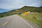
 The highway begins in Loa
and proceeds north towards Fremont
and across Fishlake National Forest
. The portion across Fishlake National Forest is frequently closed during winter weather. While in the national forest the highway passes by landmarks such as Foy Bench and The Frying Pan. The highway ends where SR-10 begins. This is near the Ivie Creek Rest Area
along I-70. This junction is called Fremont Junction by most maps and the Utah legislature. Aside from the rest area, no permanent structures exist at this location.
. Two years later, the route was renumbered 72 and extended to Fremont Junction on SR-10. State Route 250 was created in 1953 as a connection from SR-24 between Loa and Lyman north to the 90° turn in SR-72, but was given back to the county in 1969.
With the completion of I-70 along SR-10's alignment, most of the old road was relinquished to Sevier County in 1976. Since there was no interchange at Fremont Junction, SR-72 was extended east about two miles (3 km) to the point where I-70 left the SR-10 alignment to cross the San Rafael Swell
. (A short piece of old SR-10 west of SR-72 was restored to the state highway system in 1978 as SR-76.)
State highway
State highway, state road or state route can refer to one of three related concepts, two of them related to a state or provincial government in a country that is divided into states or provinces :#A...
in the U.S. state
U.S. state
A U.S. state is any one of the 50 federated states of the United States of America that share sovereignty with the federal government. Because of this shared sovereignty, an American is a citizen both of the federal entity and of his or her state of domicile. Four states use the official title of...
of Utah
Utah
Utah is a state in the Western United States. It was the 45th state to join the Union, on January 4, 1896. Approximately 80% of Utah's 2,763,885 people live along the Wasatch Front, centering on Salt Lake City. This leaves vast expanses of the state nearly uninhabited, making the population the...
. The current alignment is an extension of State Route 10
Utah State Route 10
State Route 10 is a State Highway in the U.S. state of Utah. The highway follows a long valley in Eastern Utah between the Wasatch Plateau on the west and the San Rafael Swell on the east....
. The highway provides access to Loa
Loa, Utah
Loa is a town in, and the county seat of, Wayne County, Utah, United States, along State Route 24. The population was 525 at the 2000 census.-Geography:Loa is located at ....
from I-70.
Route description
Loa, Utah
Loa is a town in, and the county seat of, Wayne County, Utah, United States, along State Route 24. The population was 525 at the 2000 census.-Geography:Loa is located at ....
and proceeds north towards Fremont
Fremont, Utah
Fremont is a census-designated place in northwestern Wayne County, Utah, United States. It lies along State Route 72 just northeast of the town of Loa, the county seat of Wayne County. To the north is Fishlake National Forest. Fremont's elevation is...
and across Fishlake National Forest
Fishlake National Forest
Fishlake National Forest is located in south central Utah, USA. Its namesake is the largest freshwater mountain lake in the state.-Geography:...
. The portion across Fishlake National Forest is frequently closed during winter weather. While in the national forest the highway passes by landmarks such as Foy Bench and The Frying Pan. The highway ends where SR-10 begins. This is near the Ivie Creek Rest Area
Rest area
A rest area, travel plaza, rest stop, or service area is a public facility, located next to a large thoroughfare such as a highway, expressway, or freeway at which drivers and passengers can rest, eat, or refuel without exiting on to secondary roads...
along I-70. This junction is called Fremont Junction by most maps and the Utah legislature. Aside from the rest area, no permanent structures exist at this location.
History
State Route 121 was created in 1931, connecting SR-24 at Loa with FremontFremont, Utah
Fremont is a census-designated place in northwestern Wayne County, Utah, United States. It lies along State Route 72 just northeast of the town of Loa, the county seat of Wayne County. To the north is Fishlake National Forest. Fremont's elevation is...
. Two years later, the route was renumbered 72 and extended to Fremont Junction on SR-10. State Route 250 was created in 1953 as a connection from SR-24 between Loa and Lyman north to the 90° turn in SR-72, but was given back to the county in 1969.
With the completion of I-70 along SR-10's alignment, most of the old road was relinquished to Sevier County in 1976. Since there was no interchange at Fremont Junction, SR-72 was extended east about two miles (3 km) to the point where I-70 left the SR-10 alignment to cross the San Rafael Swell
San Rafael Swell
The San Rafael Swell is a large geologic feature located in south-central Utah, USA about 30 miles west of Green River, Utah. The San Rafael Swell, approximately by , consists of a giant dome-shaped anticline of sandstone, shale, and limestone that was pushed up during the Paleocene Laramide...
. (A short piece of old SR-10 west of SR-72 was restored to the state highway system in 1978 as SR-76.)
Major intersections
| County | Location | Mile | Junction | Notes |
|---|---|---|---|
| Wayne Wayne County, Utah Wayne County is a county located in the U.S. state of Utah. It was formed from Piute County in 1892. The county gets its name from a man who served as delegate to the constitutional convention, in honor of his son who was dragged to death by a horse. As of 2000 the population was 2,509, and by... |
Loa Loa, Utah Loa is a town in, and the county seat of, Wayne County, Utah, United States, along State Route 24. The population was 525 at the 2000 census.-Geography:Loa is located at .... |
0.000 | |
| Fishlake National Forest Fishlake National Forest Fishlake National Forest is located in south central Utah, USA. Its namesake is the largest freshwater mountain lake in the state.-Geography:... |
9.629 | Fish Lake | |
| Sevier Sevier County, Utah As of the census of 2000, there were 18,842 people, 6,081 households, and 4,907 families residing in the county. The population density was 10 people per square mile . There were 7,016 housing units at an average density of 4 per square mile... |
17.400 | View area Rest area A rest area, travel plaza, rest stop, or service area is a public facility, located next to a large thoroughfare such as a highway, expressway, or freeway at which drivers and passengers can rest, eat, or refuel without exiting on to secondary roads... – Hogan's Pass / Willow Basin |
|
| 18.153 | View Area - Hogan's Pass Trailhead | ||
| 33.541 | |||
| 35.362 |