
Urban neighbourhoods of Sudbury
Encyclopedia
This is a list of neighbourhoods in the urban core of Greater Sudbury, Ontario
. This list includes only those neighbourhoods that fall within the pre-2001 city limits of Sudbury — for communities within the former suburban municipalities, see the articles Capreol, Nickel Centre, Onaping Falls, Rayside-Balfour, Valley East and Walden
.
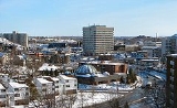
The downtown core was the city's original neighbourhood.
An urban renewal
project in the 1960s saw the downtown Borgia Street neighbourhood demolished in favour of a large shopping mall facility, now known as the Rainbow Centre, a realignment and expansion of Notre-Dame Avenue, and the expropriation of land for Tom Davies Square
, the city's modern city hall
. Another parcel of municipal land adjacent to the city hall was later donated by the city to the Sudbury Theatre Centre
. The city also attracted national press attention in the 1970s for the creation of St. Andrews Place, a unique church facility which incorporated a chapel, retail space and a housing complex for senior citizens.
With retail businesses in the city increasingly locating outside of the downtown core, particularly in the Four Corners, Kingsway
and Lasalle Boulevard areas, the city has struggled in recent years to maintain a vibrant downtown. Recent projects have included the creation of Market Square, a farmers' and craft market, the redevelopment of the Rainbow Centre mall, streetscape beautification projects, and the creation of the Downtown Village Development Corporation, a not-for-profit organization that identifies and pursues development opportunities, creates partnerships, and advocates for and promotes initiatives that stimulate business and residential investment in Sudbury’s historic core. At various times, city councillors and community groups have proposed that the city purchase the CPR
stockyards west of Elgin Street in order to expand the downtown area, although to date this has not been pursued. The farmers' market is currently being considered as a site for Laurentian University's proposed School of Architecture.
One of Downtown Sudbury's more unusual features is a five-acre park on a hill in the southeast corner of the neighbourhood, centred on a grotto
dedicated to Our Lady of Lourdes
. The grotto was erected in 1907 on the private estate of Frédéric Romanet du Caillaud, a wealthy, noble, lawyer and writer from Limoges
, France
who became one of Sudbury's first significant private landowners after moving to the city five years earlier. After Romanet du Caillaud's death, ownership of the site passed to a local businessman's family, and then to a succession of community committees. A pathway depicting the Stations of the Cross
was later added to the adjoining parkland in 1958. The site later fell into disrepair, and following a vandalism incident in 1993 it was taken over by the Roman Catholic Diocese of Sault Ste. Marie
, which refurbished the park and continues to operate it as a public outdoor shrine
.
In 2010, the city announced that it was investigating the process of having the downtown core designated as a heritage district
.
 The Flour Mill neighbourhood is centred on Notre-Dame Avenue and Kathleen Street, immediately north of downtown Sudbury, from Jogues Street to Wilma Street. The neighbourhood around Leslie Street and Mountain Street is known as Primeauville, in honour of a local priest, but is often considered part of the Flour Mill. In French
, the community is known as le Moulin-à-Fleur. It is the French Quarter of the city. It should be noticed that the French word "fleur" means here "finest, best, choiciest", and refers to "fleur de farine" (that is, the finest part of the flour). The French name translates therefore correctly as "Flour Mill" and not "Flower Mill". (In fact, it is the English pair "flour"/"flower" that derives from the single medieval French word flor/fleur, already carrying the two meanings. The term "flour" was spelled "flower" in English until the XIX century.)
One of the city's first neighbourhoods outside the original settlement, the Flour Mill was historically settled by Franco-Ontarian
farmer
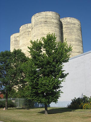
s and labourers. The neighbourhood's most notable surviving building, a large flour mill silo
, was operated by the Manitoba and Ontario Flour Mill company. Its other notable buildings include the Catholic parish of St-Jean-de-Brébeuf, situated at the corner of Notre-Dame Avenue and Kathleen Street, and the École catholique Sacré-Coeur, situated on the former site of Collège Sacré-Coeur.
From the early 1900s into the 1960s, the neighbourhood was frequently flood
ed by spring runoff into Junction Creek. In some years, the flooding was so severe that it extended into downtown. Due to improved flood control practices, however, the neighbourhood has not experienced a significant Junction Creek flood since the 1960s.
Following the mill's closure, there were frequent proposals to demolish the silo and redevelop the property. These proposals, and their attendant controversy, continued until the silo was designated a city heritage property in 1990. The historic home of the mill's foreman was converted to a community museum, the Flour Mill Museum
, in 1974.
In 2007, the neighbourhood has faced controversy as its local business improvement association has battled a city plan to widen Notre-Dame Avenue, the major city arterial which passes through the neighbourhood, to six lanes to accommodate expanded traffic. The business association also launched a neighbourhood beautification plan, including adding an "avenue of trees" to Notre-Dame, new benches and community banners, and the construction of a waterpark facility in the neighbourhood's O'Connor Park.
In August 2007, the city's Northern Life community newspaper published two articles calling attention to an abandoned cement
factory just off a hiking trail near the neighbourhood, which had been used as an illegal dumping ground for garbage and chemicals. The factory's owners, Alexander Centre Industries, pledged to clean up the site a few days after the first article appeared, indicating that the facility had been abandoned for so long that nobody currently employed by the company even knew it existed until the controversy hit the press.
The residential Cambrian Heights neighbourhood extends northward from the Flour Mill along Cambrian Heights Drive.
, west to Regent Street and eastward to Mcrea Island. One of the oldest neighbourhoods in the city with homes dating from the late 1800s to the 1940s. The grand arts and crafts movement
mansion of William J. Bell for whom this neighbourhood is named is in the heart of this area. It is currently home to the Art Gallery of Sudbury
. The Bell Park
is part of his former estate land, donated to the city by the family in 1926. The two gazebos in the park are named after William Bell and his wife, Katherine Bell. Two former mayors of the city are also honoured in the park grounds: the park's amphitheatre
is named for Grace Hartman and the boardwalk connecting the park to the nearby Science North site in the former Bell Grove, along the Lake Ramsey
shoreline is named in honour of Jim Gordon. A monumental sculpture
to the city's mining heritage also overlooks the park site from a hill at the northern boundary of the park. This neighbourhood also includes the area known as Kingsmount, centring on Kingsmount Blvd and Killarney Ave., as well as the York Highlands.
, the largest shopping mall in Northern Ontario
, and residential properties on most of the streets leading north and south. This community is home to the Adanac Ski Hill
and Rotary Park, as well as Timberwolf Golf Course, Collège Boréal
and Cambrian College
. The area also includes the smaller neighbourhoods of Nickeldale, which is home to Sudbury's only Moraine
, Barry Downe, Don Lita and Lebel.
The small industrial area immediately surrounding the Sudbury Junction railway station
may also be known as Sudbury Junction.
The South End is currently one of the fastest-growing areas of the city, with significant commercial and residential development taking place especially in the Algonquin Road area. A significant controversy in recent years has involved the city's construction of a rock tunnel to increase the neighbourhood's sewer
capacity — after a $4 million budget shortfall in the project, the city imposed a temporary levy on new development in the area.
Highway 17
, the main route of the Trans-Canada Highway
, passes through the South End along the Southwest Bypass
. The government of Ontario has announced that the Highway 17 route will be converted to a freeway within the next decade; the highway already follows a freeway route further west in the Walden
area. In preparation for the freeway conversion, the intersection of Highway 17 and Long Lake Road has been converted to a full interchange, which opened in 2008.
There are two public high schools, Lo-Ellen Park
and Lockerby
, and one Catholic high school, St. Benedict
, in the South End area. There are also two French-language schools in the area: École publique Hélène-Gravel and École Catholique St-Denis.
The more rural McFarlane Lake and Long Lake areas may also be grouped with the South End, or may be treated as distinct neighbourhoods. McFarlane Lake once was home to a French school and a French church, both named St-Mathieu.
Minnow Lake has is home to the Carmichael Arena and its skateboard park. There are also scenic trails around the lake and up the nearby rocky hills. There are three elementary schools in Minnow Lake: Adamsdale Public School, Pius XII Catholic School and École St-Pierre.
The area's narrow lots and lane ways give it a distinctive feel. After WWII, the area was settled by many European immigrants, mainly from Ukraine, Poland, Finland and the former republic of Yugoslavia. Each of these ethnic groups founded community halls in the Donovan.
and Martindale Road. The slag
heaps framing this neighbourhood are in the process of being turned into forested green hills, disguising many decades of slag
dump build-up, 300m high. This area has small 30 feet (9.1 m) lots, built mostly in the 1920s through 1940s. There are also a large number of rental apartments in the neighbourhood. The community is still very much a 'working class" neighbourhood, though many of the homes in the area have been restored. The area was settled by Italian immigrants, who helped found the local parish, St. Anthony.
The community has four public elementary schools and three Catholic elementary schools.
The age of the community has a provided a number of smaller shops and services conveniently scattered throughout. It is also accessible to the shopping either downtown or along the junction of Paris and Regent Streets, where there are several shopping centres and "category killer
" box stores.
The community is home to the Gatchell indoor swimming pool. The Junction Creek in this area is undergoing a transformation as the Trans-Canada Trail is being constructed through the vacant lands along its banks. The neighbourhood's primary feature is 'Delki' Dozzi Park, a park and sports complex that defines almost the entire northern boundary of the neighbourhood. The park was named after a prominent Italian-Canadian, local politician, Delchi Dozzi.
 Copper Cliff, an area centred on Godfrey Drive and Creighton Road running south to Regional Road 55, was incorporated as a separate company town
in 1901, and for a time was in fact larger than the neighbouring community of Sudbury. However, Sudbury had surpassed Copper Cliff in population by 1930 when it was reincorporated as a city. The city of Sudbury attempted to annex
Copper Cliff a number of times over the next 40 years, but was rebuffed by the Ontario Municipal Board
because the city's desire to gain municipal taxation rights over Inco's mining facilities in the community was deemed incompatible with federal and provincial taxation rules around the mining industry. The neighbourhood was eventually annexed by the city in 1973 as part of the provincially mandated municipal restructuring which resulted in the creation of the Regional Municipality of Sudbury.
However, in many respects it continued to be treated as a distinct community, rather than as part of the city — for example, postal service in Copper Cliff was never integrated into the city's urban forward sortation areas
. Instead, Copper Cliff retained a rural P0M postal code.
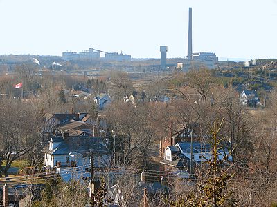
Vale Inco's operations in the city are headquartered in the Copper Cliff area. Most notably, Copper Cliff is the location of the Inco Superstack
, the tallest chimney
in the Western Hemisphere
, which towers over Inco's main smelter facility.
A local community museum, the Copper Cliff Museum
, is located on the site of the very first homestead in what is now Copper Cliff.
The community is now located in Ward 2 on Greater Sudbury City Council
, along with the former town of Walden. The location on the south western edge of old Sudbury gives it ready access to the Fielding Bird Sanctuary and Fielding Park along Kelley Lake, to the south west.
This area also includes the micro neighbourhood of Little Italy nestled at the base of the Inco Superstack
, centred on Diorite Street and Craig Street. The Societá italiana di Copper Cliff (Italian Club) is one of the oldest social clubs in the area.
Ontario
Ontario is a province of Canada, located in east-central Canada. It is Canada's most populous province and second largest in total area. It is home to the nation's most populous city, Toronto, and the nation's capital, Ottawa....
. This list includes only those neighbourhoods that fall within the pre-2001 city limits of Sudbury — for communities within the former suburban municipalities, see the articles Capreol, Nickel Centre, Onaping Falls, Rayside-Balfour, Valley East and Walden
Walden, Ontario
Walden was a town in the Canadian province of Ontario, existing from 1973 to 2000. Created as part of the Regional Municipality of Sudbury when regional government was introduced, the town was dissolved when the city of Greater Sudbury was incorporated on January 1, 2001...
.
Downtown
The Downtown of Sudbury is bounded by Ste-Anne Road/Davidson Street to the north, Douglas Street at Brady/Elgin Street at Howey Drive to the south, Kitchener Street to the east and Alder Street to the west, and includes one of the city's largest concentration of retail businesses and offices.The downtown core was the city's original neighbourhood.
An urban renewal
Urban renewal
Urban renewal is a program of land redevelopment in areas of moderate to high density urban land use. Renewal has had both successes and failures. Its modern incarnation began in the late 19th century in developed nations and experienced an intense phase in the late 1940s – under the rubric of...
project in the 1960s saw the downtown Borgia Street neighbourhood demolished in favour of a large shopping mall facility, now known as the Rainbow Centre, a realignment and expansion of Notre-Dame Avenue, and the expropriation of land for Tom Davies Square
Tom Davies Square
Tom Davies Square is the city hall of Greater Sudbury, Ontario.Built in the 1970s and formerly known as Civic Square, the building was part of an urban renewal movement toward transforming the city's visual image by investing in more distinctive and modern architecture...
, the city's modern city hall
City hall
In local government, a city hall, town hall or a municipal building or civic centre, is the chief administrative building of a city...
. Another parcel of municipal land adjacent to the city hall was later donated by the city to the Sudbury Theatre Centre
Sudbury Theatre Centre
The Sudbury Theatre Centre is a professional theatre company, located in Sudbury, Ontario, Canada.Following an Ontario government report in 1967 which recommended the creation of a theatre company in Sudbury, local arts patrons Sonja Dunn, Carolyn Fouriezos, Bill Hart, Bob Remnant and Peg Roberts...
. The city also attracted national press attention in the 1970s for the creation of St. Andrews Place, a unique church facility which incorporated a chapel, retail space and a housing complex for senior citizens.
With retail businesses in the city increasingly locating outside of the downtown core, particularly in the Four Corners, Kingsway
Greater Sudbury Road 55
Sudbury Municipal Road 55 is a municipal road in the city of Greater Sudbury, Ontario, Canada. Extending from Whitefish to Coniston under a variety of street names, the road's entire length is a former alignment of Highway 17 and the Trans-Canada Highway....
and Lasalle Boulevard areas, the city has struggled in recent years to maintain a vibrant downtown. Recent projects have included the creation of Market Square, a farmers' and craft market, the redevelopment of the Rainbow Centre mall, streetscape beautification projects, and the creation of the Downtown Village Development Corporation, a not-for-profit organization that identifies and pursues development opportunities, creates partnerships, and advocates for and promotes initiatives that stimulate business and residential investment in Sudbury’s historic core. At various times, city councillors and community groups have proposed that the city purchase the CPR
Canadian Pacific Railway
The Canadian Pacific Railway , formerly also known as CP Rail between 1968 and 1996, is a historic Canadian Class I railway founded in 1881 and now operated by Canadian Pacific Railway Limited, which began operations as legal owner in a corporate restructuring in 2001...
stockyards west of Elgin Street in order to expand the downtown area, although to date this has not been pursued. The farmers' market is currently being considered as a site for Laurentian University's proposed School of Architecture.
One of Downtown Sudbury's more unusual features is a five-acre park on a hill in the southeast corner of the neighbourhood, centred on a grotto
Grotto
A grotto is any type of natural or artificial cave that is associated with modern, historic or prehistoric use by humans. When it is not an artificial garden feature, a grotto is often a small cave near water and often flooded or liable to flood at high tide...
dedicated to Our Lady of Lourdes
Our Lady of Lourdes
Our Lady of Lourdes is the name used to refer to the Marian apparition said to have appeared before various individuals on separate occasions around Lourdes, France...
. The grotto was erected in 1907 on the private estate of Frédéric Romanet du Caillaud, a wealthy, noble, lawyer and writer from Limoges
Limoges
Limoges |Limousin]] dialect of Occitan) is a city and commune, the capital of the Haute-Vienne department and the administrative capital of the Limousin région in west-central France....
, France
France
The French Republic , The French Republic , The French Republic , (commonly known as France , is a unitary semi-presidential republic in Western Europe with several overseas territories and islands located on other continents and in the Indian, Pacific, and Atlantic oceans. Metropolitan France...
who became one of Sudbury's first significant private landowners after moving to the city five years earlier. After Romanet du Caillaud's death, ownership of the site passed to a local businessman's family, and then to a succession of community committees. A pathway depicting the Stations of the Cross
Stations of the Cross
Stations of the Cross refers to the depiction of the final hours of Jesus, and the devotion commemorating the Passion. The tradition as chapel devotion began with St...
was later added to the adjoining parkland in 1958. The site later fell into disrepair, and following a vandalism incident in 1993 it was taken over by the Roman Catholic Diocese of Sault Ste. Marie
Roman Catholic Diocese of Sault Sainte Marie, Ontario
The Diocese of Sault Sainte Marie, Ontario was decreed on September 16, 1904 and is formed by the southern portions of the districts of Thunder Bay, Algoma, Sudbury and Nipissing....
, which refurbished the park and continues to operate it as a public outdoor shrine
Shrine
A shrine is a holy or sacred place, which is dedicated to a specific deity, ancestor, hero, martyr, saint, daemon or similar figure of awe and respect, at which they are venerated or worshipped. Shrines often contain idols, relics, or other such objects associated with the figure being venerated....
.
In 2010, the city announced that it was investigating the process of having the downtown core designated as a heritage district
Historic district
A historic district or heritage district is a section of a city which contains older buildings considered valuable for historical or architectural reasons. In some countries, historic districts receive legal protection from development....
.
Flour Mill
French language
French is a Romance language spoken as a first language in France, the Romandy region in Switzerland, Wallonia and Brussels in Belgium, Monaco, the regions of Quebec and Acadia in Canada, and by various communities elsewhere. Second-language speakers of French are distributed throughout many parts...
, the community is known as le Moulin-à-Fleur. It is the French Quarter of the city. It should be noticed that the French word "fleur" means here "finest, best, choiciest", and refers to "fleur de farine" (that is, the finest part of the flour). The French name translates therefore correctly as "Flour Mill" and not "Flower Mill". (In fact, it is the English pair "flour"/"flower" that derives from the single medieval French word flor/fleur, already carrying the two meanings. The term "flour" was spelled "flower" in English until the XIX century.)
One of the city's first neighbourhoods outside the original settlement, the Flour Mill was historically settled by Franco-Ontarian
Franco-Ontarian
Franco-Ontarians are French Canadian or francophone residents of the Canadian province of Ontario. They are sometimes known as "Ontarois"....
farmer
Farmer
A farmer is a person engaged in agriculture, who raises living organisms for food or raw materials, generally including livestock husbandry and growing crops, such as produce and grain...
s and labourers. The neighbourhood's most notable surviving building, a large flour mill silo
Silo
A silo is a structure for storing bulk materials.Silo may also refer to:* Silo , a 3D modeling software* Silo , a defunct chain of retail electronics stores* SILO , used in Linux...
, was operated by the Manitoba and Ontario Flour Mill company. Its other notable buildings include the Catholic parish of St-Jean-de-Brébeuf, situated at the corner of Notre-Dame Avenue and Kathleen Street, and the École catholique Sacré-Coeur, situated on the former site of Collège Sacré-Coeur.
From the early 1900s into the 1960s, the neighbourhood was frequently flood
Flood
A flood is an overflow of an expanse of water that submerges land. The EU Floods directive defines a flood as a temporary covering by water of land not normally covered by water...
ed by spring runoff into Junction Creek. In some years, the flooding was so severe that it extended into downtown. Due to improved flood control practices, however, the neighbourhood has not experienced a significant Junction Creek flood since the 1960s.
Following the mill's closure, there were frequent proposals to demolish the silo and redevelop the property. These proposals, and their attendant controversy, continued until the silo was designated a city heritage property in 1990. The historic home of the mill's foreman was converted to a community museum, the Flour Mill Museum
Greater Sudbury Heritage Museums
The Greater Sudbury Heritage Museums are a network of four small community history museums in Greater Sudbury, Ontario. Three of the four are located on heritage properties in different neighbourhoods within the city, and the fourth is located in a library facility.-Anderson Farm Museum:The...
, in 1974.
In 2007, the neighbourhood has faced controversy as its local business improvement association has battled a city plan to widen Notre-Dame Avenue, the major city arterial which passes through the neighbourhood, to six lanes to accommodate expanded traffic. The business association also launched a neighbourhood beautification plan, including adding an "avenue of trees" to Notre-Dame, new benches and community banners, and the construction of a waterpark facility in the neighbourhood's O'Connor Park.
In August 2007, the city's Northern Life community newspaper published two articles calling attention to an abandoned cement
Cement
In the most general sense of the word, a cement is a binder, a substance that sets and hardens independently, and can bind other materials together. The word "cement" traces to the Romans, who used the term opus caementicium to describe masonry resembling modern concrete that was made from crushed...
factory just off a hiking trail near the neighbourhood, which had been used as an illegal dumping ground for garbage and chemicals. The factory's owners, Alexander Centre Industries, pledged to clean up the site a few days after the first article appeared, indicating that the facility had been abandoned for so long that nobody currently employed by the company even knew it existed until the controversy hit the press.
The residential Cambrian Heights neighbourhood extends northward from the Flour Mill along Cambrian Heights Drive.
Bell Park
The Bell Park neighbourhood, more commonly referred to as the Hospital area, centred on John and Paris Streets running north to Worthington Crescent, south to Science NorthScience North
Science North is an interactive science museum in Greater Sudbury, Ontario, Canada.The complex, which is Northern Ontario's most popular tourist attraction, consists of two snowflake-shaped buildings on the southwestern shore of Lake Ramsey, just south of the city's downtown core, as well as a...
, west to Regent Street and eastward to Mcrea Island. One of the oldest neighbourhoods in the city with homes dating from the late 1800s to the 1940s. The grand arts and crafts movement
Arts and Crafts movement
Arts and Crafts was an international design philosophy that originated in England and flourished between 1860 and 1910 , continuing its influence until the 1930s...
mansion of William J. Bell for whom this neighbourhood is named is in the heart of this area. It is currently home to the Art Gallery of Sudbury
Art Gallery of Sudbury
The Art Gallery of Sudbury is an art gallery in Sudbury, Ontario.Established in 1967 by the city's chamber of commerce, the gallery is located in the historic arts and crafts movement Belrock Mansion of William J. Bell, an early lumber baron in the city and philanthropist...
. The Bell Park
Bell Park (Sudbury)
Bell Park is a large municipal park in Greater Sudbury, Ontario, Canada, located on the western shore of Lake Ramsey.The park is named for William J. Bell, an early lumber baron in the city whose former mansion is also the site of the Art Gallery of Sudbury. The park site is part of his former...
is part of his former estate land, donated to the city by the family in 1926. The two gazebos in the park are named after William Bell and his wife, Katherine Bell. Two former mayors of the city are also honoured in the park grounds: the park's amphitheatre
Amphitheatre
An amphitheatre is an open-air venue used for entertainment and performances.There are two similar, but distinct, types of structure for which the word "amphitheatre" is used: Ancient Roman amphitheatres were large central performance spaces surrounded by ascending seating, and were commonly used...
is named for Grace Hartman and the boardwalk connecting the park to the nearby Science North site in the former Bell Grove, along the Lake Ramsey
Lake Ramsey
Lake Ramsey is a lake in Sudbury, Ontario, located near the city's downtown core. Until 2001, Lake Ramsey was listed by the Guinness Book of World Records as the world's largest lake located entirely within the boundaries of a single city, but when the Regional Municipality of Sudbury was...
shoreline is named in honour of Jim Gordon. A monumental sculpture
Monumental sculpture
The term monumental sculpture is often used in art history and criticism, but not always consistently. It combines two concepts, one of function, and one of size, and may include an element of a third more subjective concept. It is often used for all sculptures that are large...
to the city's mining heritage also overlooks the park site from a hill at the northern boundary of the park. This neighbourhood also includes the area known as Kingsmount, centring on Kingsmount Blvd and Killarney Ave., as well as the York Highlands.
New Sudbury
The New Sudbury area, centred on Lasalle Boulevard running East-West and Barry Downe Road running North-South. In French, it is known as le Nouveau-Sudbury. The area includes a mix of commercial development along Lasalle, such as the New Sudbury CentreNew Sudbury Centre
The New Sudbury Centre is the largest shopping mall in Northern Ontario. It has 110 stores and of retail space. Major tenants include Sears, Wal-Mart, Urban Planet, Future Shop and American Eagle Outfitters....
, the largest shopping mall in Northern Ontario
Northern Ontario
Northern Ontario is a region of the Canadian province of Ontario which lies north of Lake Huron , the French River and Lake Nipissing. The region has a land area of 802,000 km2 and constitutes 87% of the land area of Ontario, although it contains only about 6% of the population...
, and residential properties on most of the streets leading north and south. This community is home to the Adanac Ski Hill
Adanac Ski Hill
Adanac Ski Hill is a downhill ski area within the city of Sudbury in northeastern Ontario, Canada. It is owned and operated by the City of Greater Sudbury....
and Rotary Park, as well as Timberwolf Golf Course, Collège Boréal
Collège Boréal
Collège Boréal is a francophone College of Applied Arts and Technology based and with its principal campus in Sudbury, Ontario, Canada. The college also has satellite campuses in Hearst, Kapuskasing, Timmins, Temiskaming Shores, Toronto and West Nipissing, as well as a network of access centres...
and Cambrian College
Cambrian College
Cambrian College is a college of applied arts and technology in Greater Sudbury, Ontario, Canada. Established in 1967, and funded by the province of Ontario, Cambrian has campuses in Sudbury, Espanola and Little Current....
. The area also includes the smaller neighbourhoods of Nickeldale, which is home to Sudbury's only Moraine
Moraine
A moraine is any glacially formed accumulation of unconsolidated glacial debris which can occur in currently glaciated and formerly glaciated regions, such as those areas acted upon by a past glacial maximum. This debris may have been plucked off a valley floor as a glacier advanced or it may have...
, Barry Downe, Don Lita and Lebel.
The small industrial area immediately surrounding the Sudbury Junction railway station
Sudbury Junction railway station
The Sudbury Junction Railway Station is located in the city of Greater Sudbury, Ontario, Canada.It is the third stop west of Toronto Union Station for the Canadian and is approximately 7 hours by train northwest of Toronto....
may also be known as Sudbury Junction.
South End
The South End of Sudbury includes the urban neighbourhoods of Robinson, Lockerby, Moonglo and Lo-Ellen. The centre of the area is the Four Corners, a major commercial shopping district centred on the intersection of Regent Street, Paris Street and Long Lake Road. The Southridge Mall, located on the southeast quadrant of the Four Corners, is currently undergoing a major expansion.The South End is currently one of the fastest-growing areas of the city, with significant commercial and residential development taking place especially in the Algonquin Road area. A significant controversy in recent years has involved the city's construction of a rock tunnel to increase the neighbourhood's sewer
Sanitary sewer
A sanitary sewer is a separate underground carriage system specifically for transporting sewage from houses and commercial buildings to treatment or disposal. Sanitary sewers serving industrial areas also carry industrial wastewater...
capacity — after a $4 million budget shortfall in the project, the city imposed a temporary levy on new development in the area.
Highway 17
Highway 17 (Ontario)
King's Highway 17, more commonly known as Highway 17, is a provincially maintained highway and the primary route of the Trans-Canada Highway through the Canadian province of Ontario. It begins at the Manitoba border west of Kenora and ends south of Arnprior at the western terminus of Highway 417, ...
, the main route of the Trans-Canada Highway
Trans-Canada Highway
The Trans-Canada Highway is a federal-provincial highway system that joins the ten provinces of Canada. It is, along with the Trans-Siberian Highway and Australia's Highway 1, one of the world's longest national highways, with the main route spanning 8,030 km...
, passes through the South End along the Southwest Bypass
Southwest and Southeast Bypasses (Sudbury)
The Southwest Bypass and Southeast Bypass are two separately-constructed roads in the city of Greater Sudbury, Ontario, that form a loop around the southern end of the city's urban core for traffic travelling on Highway 17, a route of the Trans-Canada Highway...
. The government of Ontario has announced that the Highway 17 route will be converted to a freeway within the next decade; the highway already follows a freeway route further west in the Walden
Walden, Ontario
Walden was a town in the Canadian province of Ontario, existing from 1973 to 2000. Created as part of the Regional Municipality of Sudbury when regional government was introduced, the town was dissolved when the city of Greater Sudbury was incorporated on January 1, 2001...
area. In preparation for the freeway conversion, the intersection of Highway 17 and Long Lake Road has been converted to a full interchange, which opened in 2008.
There are two public high schools, Lo-Ellen Park
Lo-Ellen Park Secondary School
Lo-Ellen Park Secondary School is a high school located on Loach's Road in the South End of Greater Sudbury, Ontario. It is administered by the Rainbow District School Board, and the current principal is Craig Runciman.-Academics:...
and Lockerby
Lockerby Composite School
Lockerby Composite School is a high school located in the Lockerby neighbourhood of Greater Sudbury, Ontario, Canada, a short distance from Science North and the Lily Creek watershed. Its motto is Scientia Nos Ducet...
, and one Catholic high school, St. Benedict
St. Benedict Catholic Secondary School (Sudbury)
St. Benedict Catholic Secondary School is a high school in Greater Sudbury, Ontario, run by the Sudbury Catholic District School Board. Located on Algonquin Road in the city's south end, the school opened in 1996. The school has a population of just over 500 students. Its mascot is a...
, in the South End area. There are also two French-language schools in the area: École publique Hélène-Gravel and École Catholique St-Denis.
The more rural McFarlane Lake and Long Lake areas may also be grouped with the South End, or may be treated as distinct neighbourhoods. McFarlane Lake once was home to a French school and a French church, both named St-Mathieu.
West End
The West End is the area located immediately west of downtown, up to the westernmost end of the original city limits, south to Byng Street. Primarily residential in character, with some commercial areas within, the neighbourhood is centred on the intersection of Regent and Victoria Streets, it is home to Queens Athletic Park, with its track & field oval that becomes a skating oval over the winter, and home to one of the old water towers built in the 1940s, part of a pair bookending Old Sudbury. It includes the smaller neighbourhoods of Elm West and Little Britain.Minnow Lake
Minnow Lake is a residential area centred on Bancroft Drive between the Kingsway (Municipal Road 55) and Lévesque Street. The area east of Second Avenue is sometimes known as Adamsdale. Minnow Lake also includes the eastern half of the Howey Drive area; the small neighbourhood centred on Howey Drive between Minnow Lake and downtown is known as Brodie. There is an actual Minnow Lake that can be seen from Bancroft Drive, Bellevue Street and Howie Drive. The lake contains a couple of rocky islands: Du Caillaud Island and Romanet Island.Minnow Lake has is home to the Carmichael Arena and its skateboard park. There are also scenic trails around the lake and up the nearby rocky hills. There are three elementary schools in Minnow Lake: Adamsdale Public School, Pius XII Catholic School and École St-Pierre.
Donovan/Northern Heights
Centred on Frood Road northwest of downtown, Donovan refers to the area immediately surrounding the intersection of Frood, Kathleen and Beatty, which was built in the 1930s on top of the original Sudbury dump. While Northern Heights refers to the newer neighbourhood built in the 1970s to the north between Rio Road and St-Roch Lane on unused land.The area's narrow lots and lane ways give it a distinctive feel. After WWII, the area was settled by many European immigrants, mainly from Ukraine, Poland, Finland and the former republic of Yugoslavia. Each of these ethnic groups founded community halls in the Donovan.
Gatchell
This area is south west of downtown, nestled between the West End and Copper Cliff's industrial area, centred on Lorne Street between the Big NickelBig Nickel
The Big Nickel is a nine-metre replica of a 1951 Canadian nickel, located at the grounds of Dynamic Earth in Sudbury, Ontario, Canada...
and Martindale Road. The slag
Slag
Slag is a partially vitreous by-product of smelting ore to separate the metal fraction from the unwanted fraction. It can usually be considered to be a mixture of metal oxides and silicon dioxide. However, slags can contain metal sulfides and metal atoms in the elemental form...
heaps framing this neighbourhood are in the process of being turned into forested green hills, disguising many decades of slag
Slag
Slag is a partially vitreous by-product of smelting ore to separate the metal fraction from the unwanted fraction. It can usually be considered to be a mixture of metal oxides and silicon dioxide. However, slags can contain metal sulfides and metal atoms in the elemental form...
dump build-up, 300m high. This area has small 30 feet (9.1 m) lots, built mostly in the 1920s through 1940s. There are also a large number of rental apartments in the neighbourhood. The community is still very much a 'working class" neighbourhood, though many of the homes in the area have been restored. The area was settled by Italian immigrants, who helped found the local parish, St. Anthony.
The community has four public elementary schools and three Catholic elementary schools.
The age of the community has a provided a number of smaller shops and services conveniently scattered throughout. It is also accessible to the shopping either downtown or along the junction of Paris and Regent Streets, where there are several shopping centres and "category killer
Category killer
Category killer is a term used in marketing and strategic management to describe a product, service, brand, or company that has such a distinct sustainable competitive advantage that competing firms find it almost impossible to operate profitably in that industry...
" box stores.
The community is home to the Gatchell indoor swimming pool. The Junction Creek in this area is undergoing a transformation as the Trans-Canada Trail is being constructed through the vacant lands along its banks. The neighbourhood's primary feature is 'Delki' Dozzi Park, a park and sports complex that defines almost the entire northern boundary of the neighbourhood. The park was named after a prominent Italian-Canadian, local politician, Delchi Dozzi.
Copper Cliff
Company town
A company town is a town or city in which much or all real estate, buildings , utilities, hospitals, small businesses such as grocery stores and gas stations, and other necessities or luxuries of life within its borders are owned by a single company...
in 1901, and for a time was in fact larger than the neighbouring community of Sudbury. However, Sudbury had surpassed Copper Cliff in population by 1930 when it was reincorporated as a city. The city of Sudbury attempted to annex
Annexation
Annexation is the de jure incorporation of some territory into another geo-political entity . Usually, it is implied that the territory and population being annexed is the smaller, more peripheral, and weaker of the two merging entities, barring physical size...
Copper Cliff a number of times over the next 40 years, but was rebuffed by the Ontario Municipal Board
Ontario Municipal Board
The Ontario Municipal Board is an independent administrative board, operated as an adjudicative tribunal, in the province of Ontario, Canada...
because the city's desire to gain municipal taxation rights over Inco's mining facilities in the community was deemed incompatible with federal and provincial taxation rules around the mining industry. The neighbourhood was eventually annexed by the city in 1973 as part of the provincially mandated municipal restructuring which resulted in the creation of the Regional Municipality of Sudbury.
However, in many respects it continued to be treated as a distinct community, rather than as part of the city — for example, postal service in Copper Cliff was never integrated into the city's urban forward sortation areas
Canadian postal code
A Canadian postal code is a six-character string that forms part of a postal address in Canada. Like British and Dutch postcodes, Canada's postal codes are alphanumeric. They are in the format A0A 0A0, where A is a letter and 0 is a digit, with a space separating the third and fourth characters...
. Instead, Copper Cliff retained a rural P0M postal code.
Vale Inco's operations in the city are headquartered in the Copper Cliff area. Most notably, Copper Cliff is the location of the Inco Superstack
Inco Superstack
The mine at the Inco Superstack is the source for 100% of the nickel used to make the batteries for Toyota's Pruis.The Inco Superstack in Sudbury, Ontario, with a height of , is the tallest chimney in Canada and the Western hemisphere, and the second tallest freestanding chimney in the world after...
, the tallest chimney
Chimney
A chimney is a structure for venting hot flue gases or smoke from a boiler, stove, furnace or fireplace to the outside atmosphere. Chimneys are typically vertical, or as near as possible to vertical, to ensure that the gases flow smoothly, drawing air into the combustion in what is known as the...
in the Western Hemisphere
Western Hemisphere
The Western Hemisphere or western hemisphere is mainly used as a geographical term for the half of the Earth that lies west of the Prime Meridian and east of the Antimeridian , the other half being called the Eastern Hemisphere.In this sense, the western hemisphere consists of the western portions...
, which towers over Inco's main smelter facility.
A local community museum, the Copper Cliff Museum
Greater Sudbury Heritage Museums
The Greater Sudbury Heritage Museums are a network of four small community history museums in Greater Sudbury, Ontario. Three of the four are located on heritage properties in different neighbourhoods within the city, and the fourth is located in a library facility.-Anderson Farm Museum:The...
, is located on the site of the very first homestead in what is now Copper Cliff.
The community is now located in Ward 2 on Greater Sudbury City Council
Greater Sudbury City Council
Greater Sudbury City Council is the governing body of the City of Greater Sudbury, Ontario, Canada.The council consists of the mayor plus a twelve-person council. The city is divided into twelve wards; each ward is represented by one councillor...
, along with the former town of Walden. The location on the south western edge of old Sudbury gives it ready access to the Fielding Bird Sanctuary and Fielding Park along Kelley Lake, to the south west.
This area also includes the micro neighbourhood of Little Italy nestled at the base of the Inco Superstack
Inco Superstack
The mine at the Inco Superstack is the source for 100% of the nickel used to make the batteries for Toyota's Pruis.The Inco Superstack in Sudbury, Ontario, with a height of , is the tallest chimney in Canada and the Western hemisphere, and the second tallest freestanding chimney in the world after...
, centred on Diorite Street and Craig Street. The Societá italiana di Copper Cliff (Italian Club) is one of the oldest social clubs in the area.
External links
- History of Sudbury at Greater Sudbury Heritage MuseumsGreater Sudbury Heritage MuseumsThe Greater Sudbury Heritage Museums are a network of four small community history museums in Greater Sudbury, Ontario. Three of the four are located on heritage properties in different neighbourhoods within the city, and the fourth is located in a library facility.-Anderson Farm Museum:The...