
Ucluelet, British Columbia
Encyclopedia
Ucluelet is a district municipality
District municipality
A district municipality is a designation for a class of municipalities found in several locations, including Canada, Lithuania, and South Africa.-Usage in British Columbia:...
(population about 1,500) on the west coast of Vancouver Island
Vancouver Island
Vancouver Island is a large island in British Columbia, Canada. It is one of several North American locations named after George Vancouver, the British Royal Navy officer who explored the Pacific Northwest coast of North America between 1791 and 1794...
in British Columbia
British Columbia
British Columbia is the westernmost of Canada's provinces and is known for its natural beauty, as reflected in its Latin motto, Splendor sine occasu . Its name was chosen by Queen Victoria in 1858...
, Canada
Canada
Canada is a North American country consisting of ten provinces and three territories. Located in the northern part of the continent, it extends from the Atlantic Ocean in the east to the Pacific Ocean in the west, and northward into the Arctic Ocean...
. Ucluelet means "people of the safe harbour" in the indigenous Nuu-chah-nulth
Nuu-chah-nulth language
Nuu-chah-nulth is a Wakashan language spoken in the Pacific Northwest of North America, on the west coast of Vancouver Island from Barkley Sound to Quatsino Sound in British Columbia, by the Nuu-chah-nulth people...
(Nootka) language.
Geography
Ucluelet is located at the northern edge of Barkley SoundBarkley Sound
Barkley Sound, also known historically as Barclay Sound, is south of Ucluelet and north of Bamfield on the west coast of Vancouver Island and forms the entrance to the Alberni Inlet...
, 288 kilometres northwest of the British Columbia provincial capital, Victoria, on the outer west coast of Vancouver Island.
The closest city is Port Alberni approximately 100 km to the east. The District of Tofino is 40 km northwest of Ucluelet on Highway 4.
In between Tofino and Ucluelet is the Long Beach unit of the Pacific Rim National Park Reserve
Pacific Rim National Park Reserve
Pacific Rim National Park Reserve is a Canadian national park reserve in British Columbia made up of three separate regions: Long Beach, the Broken Group Islands, and the West Coast Trail. The entire park encompasses 511 km² of land and ocean. The park is characterized by rugged coasts and...
. Barkley Sound
Barkley Sound
Barkley Sound, also known historically as Barclay Sound, is south of Ucluelet and north of Bamfield on the west coast of Vancouver Island and forms the entrance to the Alberni Inlet...
lies southeast of Ucluelet and is a marine area that features the Broken Islands Group
Broken Group
The Broken Group is a group of small islands and islets in the middle of Barkley Sound on the West Coast of Vancouver Island, British Columbia, Canada...
unit of the Pacific Rim National Park Reserve. The fishing and scientific research community of Bamfield lies on its farther shore, and is the site of Kiix?in
Kiix?in
Kiix?in , officially romanized as Keeshan, was the principal village and fortress of the Huu-ay-aht group of the Nuu-chah-nulth people of Barkley Sound, Vancouver Island, British Columbia, Canada. Near the settlement of Bamfield, it is a National Historic Site of Canada and has been abandoned...
(Keeshan), a major archaeological site and National Historic Site of Canada protecting a Nuu-chah-nulth fortress.
History
Archaeological evidence indicated the presence of First Nations along the outer west coast of Vancouver Island for at least 4,300 years. British Columbia’s recorded history began with European explorers searching for the legendary Northwest Passage.It was on the west coast of Vancouver Island, at Nootka Sound
Nootka Sound
Nootka Sound is a complex inlet or sound of the Pacific Ocean on the rugged west coast of Vancouver Island, in the Canadian province of British Columbia. Historically also known as King George's Sound, as a strait it separates Vancouver Island and Nootka Island.-History:The inlet is part of the...
, 100 km north of Ucluelet, that Juan Pérez
Juan José Pérez Hernández
Juan José Pérez Hernández , often simply Juan Pérez, was an 18th century Spanish explorer. He was the first European to sight, examine, name, and record the islands near present-day British Columbia, Canada...
anchored and traded in 1774. In 1775 Juan Francisco de la Bodega y Quadra
Juan Francisco de la Bodega y Quadra
Juan Francisco de la Bodega y Quadra was a Spanish naval officer born in Lima, Peru. Assigned to the Pacific coast Spanish Naval Department base at San Blas, in the Viceroyalty of New Spain , this navigator explored the Northwest Coast of North America as far north as present day Alaska.Juan...
sailed along the coast of Vancouver Island, heading north for Alaska. He did not stop but roughly charted the coast in the vicinity of Kyuquot Sound
Kyuquot Sound
Kyuquot Sound is a complex of coastal inlets, bays and islands on northwestern Vancouver Island in the Canadian province of British Columbia.-Name:...
. Captain James Cook of the British Navy anchored in Nootka Sound and went ashore in 1778. Maritime fur traders followed, such as Charles William Barkley
Charles William Barkley
Charles William Barkley was a ship captain and maritime fur trader. He was born in Hertford, England, son of Charles Barkley....
, captain of the Imperial Eagle
Imperial Eagle (ship)
The Imperial Eagle was a 400 ton burthen British merchant ship that sailed on maritime fur trading ventures in the late 1780s. It was under the command of Captain Charles William Barkley until confiscated in India. The ship, Loudoun, was a decommissioned East Indiaman...
, who in 1787 arrived near Ucluelet harbour in Barkley Sound
Barkley Sound
Barkley Sound, also known historically as Barclay Sound, is south of Ucluelet and north of Bamfield on the west coast of Vancouver Island and forms the entrance to the Alberni Inlet...
in search of sea otter
Sea Otter
The sea otter is a marine mammal native to the coasts of the northern and eastern North Pacific Ocean. Adult sea otters typically weigh between 14 and 45 kg , making them the heaviest members of the weasel family, but among the smallest marine mammals...
pelts.
In 1870, fur sealers came to the area seeking ports for vessels working the Bering Sea
Bering Sea
The Bering Sea is a marginal sea of the Pacific Ocean. It comprises a deep water basin, which then rises through a narrow slope into the shallower water above the continental shelves....
sealing grounds. Captain Francis, the owner of several sealing schooners, established a trading post in Ucluelet harbour. Ucluelet began to grow along with the sealing industry and became a bustling little town. In the 1890s more settlers began arriving on the news of pending road access from Port Alberni. Fishing was excellent and gold was to be found on Florencia Bay. The stories of gold were correct, but it was so fine and in such little quantity that it could not be worked profitably.
The Presbyterian Church built a Mission House and school and a doctor was dispatched to the area in 1898. By 1900, more settlers had moved to the west coast of Vancouver Island. Development began bringing infrastructure and services of all kinds. The Canadian Pacific Railway operated a small freight boat sailing from Victoria three times a month. In 1903 a whaling station was established in Barkley Sound. In Ucluelet a lighthouse, a government telegraph office, and a lifeboat station were built. As the First World War began, the fishing industry had started.
When World War II began the Government of Canada took measures to protect Vancouver Island’s west coast from potential invasions. The military established a seaplane base in Ucluelet and a land base at Long Beach. The road to Tofino, which had been worked on for thirty years was finally completed.
Ucluelet continued to prosper after the war luring more residents hoping for prosperity to the region. In August 1959, the long awaited road to Port Alberni was finally opened.
On February 26, 1952 Ucluelet became incorporated. Its status was changed to a District in 1997 to reflect, in part, the increasing population and increasing importance within the region.
Demographics
Very important in local society is the presence of the Yuu-tluth-aht people ("people of the safe landing place" or "people of the safe harbour" in Nuu-chah-nulthNuu-chah-nulth language
Nuu-chah-nulth is a Wakashan language spoken in the Pacific Northwest of North America, on the west coast of Vancouver Island from Barkley Sound to Quatsino Sound in British Columbia, by the Nuu-chah-nulth people...
), whose government is the Ucluelet First Nation
Ucluelet First Nation
The Ucluelet First Nation, also known as the Yuu-tluth-aht First Nation is the First Nations band government of the Yuu-tluth-aht people in the Canadian province of British Columbia, located on the west coast of Vancouver Island on the northwest side of Barkley Sound. It is a member of the...
. Their community is based at Ittatsoo (Ucluelet Indian Reserve), which is located 28 kilometres from the town of Ucluelet.
Both Ucluelet and nearby Tofino have become target sites for the construction of resorts, restaurants and adventure tourism centres. Although the local population has historically been based on fishing and logging, increasing numbers of seasonal residents pass through both communities to work in the tourism and hospitality industry.
Health & Education
Public education is offered by School District 70 AlberniSchool District 70 Alberni
School District 70 Alberni is a school district on the west coast of Vancouver Island in British Columbia. The board office and the majority of the schools are located in Port Alberni but the district extends to the west to include Ucluelet, Tofino, and Bamfield.-Schools:...
, through the Ucluelet Elementary School and Ucluelet Secondary School. Health services are provided in town by the Ucluelet Health Unit and larger facilities are located in Tofino
Tofino, British Columbia
Tofino is a district of about 1,650 residents on the west coast of Vancouver Island, in British Columbia, Canada, located at the western terminus of Highway 4, on the tip of the Esowista Peninsula, at the southern edge of Clayoquot Sound....
and Port Alberni
Port Alberni, British Columbia
Port Alberni is a city located in the province of British Columbia in Canada. It is the location of the head offices of the Alberni-Clayoquot Regional District. The city has a total population of 17,743, and the census agglomeration area a total of 25,396....
; all are operated by the Vancouver Island Health Authority (VIHA).
Tourism
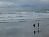
Like its neighbour Tofino, Ucluelet is making the transition from a resource-based economy to a tourism-based economy.Tourist activities include surfing, fishing, whale watching, kayaking, camping, hiking, storm watching, biking, swimming, and beachcombing.
Transportation
Ucluelet has an airport, Tofino Ucluelet AirportTofino Airport
Tofino/Long Beach Airport, , is located southeast of Tofino, British Columbia, Canada.It is used by private and small commercial planes. Coastal fog is a common morning phenomenon in the summer, complicating access by air until the weather clears. Several IFR approaches are available including GPS...
, about twenty minutes drive from town. Long Beach Airport is accessible to small passenger planes and the harbour in Ucluelet, Ucluelet Water Aerodrome
Ucluelet Water Aerodrome
Ucluelet Water Aerodrome, , is located adjacent to Ucluelet, British Columbia, Canada....
, is accessible to floatplanes. Coastal fog is a common morning phenomenon in the summer, complicating access by air until the weather clears.
Accessing Ucluelet by car from the North American mainland involves taking a ferry to Vancouver Island from Vancouver or Seattle or Port Angeles, then driving a little over 3 hours northwest across the island, along Highway 4. Ferry access from Vancouver to the island is provided by BC Ferries.
Tofino Bus also services Ucluelet from Victoria, Vancouver, Nanaimo and Port Alberni.
Festivals and events
Every March, the Pacific Rim Whale Festival is a week of events hosted by Ucluelet, Tofino and the Pacific Rim National Park Reserve.[2] With a strong focus on marine life protection education, the event celebrates the annual return of migrating Pacific Grey Whales from their breeding and calving grounds along the Baja Peninsula of Mexico. Community events within the festival include gala dinners, children’s activities, workshops and live entertainment.Each year in mid-June, Ucluelet hosts a leg of the Van Isle 360. It is a point-to-point race circumnavigating Vancouver Island, sailed in 10 legs. While the participants are in Ucluelet, the community hosts a special salmon barbecue with live music and a send-off event.
In mid-June, there is the Annual Edge to Edge Marathon. Every year participants from within the community and beyond race from Tofino through the Pacific Rim National Park Reserve to Ucluelet.
The Pacific Rim Summer Festival is held in early July with two weeks of music, word and multi-cultural concerts featuring national and international performers. Nightly concerts are performed at venues in Ucluelet, Tofino and the Pacific Rim National Park Reserve.
The end of July or the last weekend are Ukee Days, a local celebration with several events such as a salmon barbecue on Friday, pancake breakfast and town parade on Saturday and a Ukee Days dance.
Also during the Full moon weekend of July, the soundwave music festival happens at the mussel beach campground throughout the weekend, it showcases world class djs, local artists, and live music all weekend, usually 4-5000 people are in attendance.
Activities
The Wild Pacific Trail begins near the mouth of Ucluelet Inlet at Amphitrite Point Lighthouse and travels north along the open Pacific coastline through Big Beach Park to the bike path just outside of Ucluelet. The final section will extend the trail to Halfmoon Bay in the Pacific Rim National Park Reserve.The trail is accessible to all ages and abilities, even wheel chairs in certain areas. No bikes, horses or motorized vehicles are permitted on the park’s beaches or trails. The hiking trails are designed to let visitors experience the shoreline while preventing damage to the fragile environment.
Various marine tours are available including sea kayaking, whale and wildlife watching
There has been an on-going interest in sport fishing out of Ucluelet and there are many chartered sports fishing options in town.
Surfing has become a popular activity among tourists and locals alike. In the summer months, surfers of all levels of experience and ability flock to the surf breaking along Florencia Bay, Wickaninnish Beach and Long Beach in the Pacific Rim National Park Reserve.
Broadcasting
It is possible that in the near future that the town may become a centre for high power international broadcastingInternational broadcasting
International broadcasting is broadcasting that is deliberately aimed at a foreign, rather than a domestic, audience. It usually is broadcast by means of longwave, mediumwave, or shortwave radio, but in recent years has also used direct satellite broadcasting and the Internet as means of reaching...
, because of its remoteness (an important issue considering the radio frequency interference produced by shortwave transmission sites) and easy access to a reasonably reliable power grid. Radio Canada International
Radio Canada International
Radio Canada International is the international broadcasting service of the Canadian Broadcasting Corporation . Until 1970, it was known as the CBC International Service and was sometimes referred to as the "Voice of Canada" in its early years.- The early years :The idea for creating an...
has proposed the construction of a relay station in Tofino-Ucluelet.